Transcription
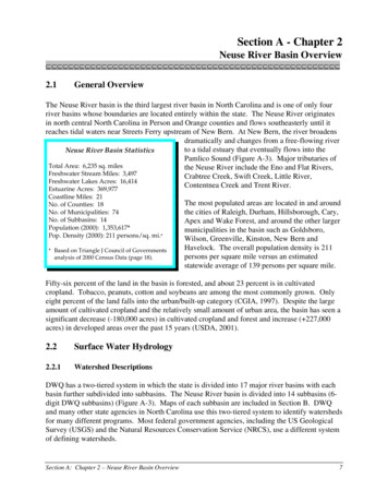
Division of FisheriesRegion II Streams Program5931 Fox River DrivePlano, IL 60548Current Status of Fish Assemblages and theSport Fishery in the Des Plaines River Watershed –Changes over 44 years of Basin SurveysekMill AI YPLSDER#YDuPage River#YWILL#YT # Brandon Lock and DamY#YStephen Pescitelli and Tristan WidloeDivision of FisheriesStephen5931PescitelliandDriveTristan WidloeFox RiverPlano, IL 60545steve.pescitelli@illinois.gov
2 D e s P l a i n e s R i v e r B a s i n S u r v e yExecutive SummaryThis report summarizes the fish sampling portion of the 2018 IDNR/IEPA basin survey in the Des PlainesRiver Watershed, with descriptions of current species composition, distribution, stream quality, and sport fisherystatus, including comparisons to six previous basin surveys over the past 44 years. We also discuss recentimprovements and future threats to ongoing restoration efforts, including the Brandon Road Lock and Dam(BRLD) fish barrier.Ten thousand six hundred sixty-seven fish were collected at 32 stations throughout the Des Plaines Riverand its tributaries in 2018, representing 15 families and 70 species. Three State Threatened fish species werecollected: Blackchin Shiner, Banded Killifish and Iowa Darter. Non-native fish species included Common Carp,Goldfish, and Round Goby. No Asian Carp species were collected or observed.Sixteen Des Plaines River mainstem stations yielded 3,763 fish, including 54 native species and three nonnative species: Common Carp, Goldfish, and Round Goby. Two State Listed species were collected from themainstem: Iowa Darter and Blackchin Shiner. Species richness at individual station ranged from 13 species at I-55Bridge (G-01) to 31 at Riverside (G-39). Bluegill, Largemouth Bass, Bluntnose Minnow, Gizzard Shad, and GreenSunfish were the most abundant species in 2018. The number of fish species collected on the mainstem in 2018(n 54) were similar to the last survey in 2013 (n 57). However, species richness on the mainstem has improvedsubstantially since 1974 when only 20 species were collected at fourteen stations. In five basin surveys from1983 to 2013, 44 fish species have been collected upstream of BRLD which were not present in 1974. Reducedfish species richness in earlier surveys in 1974 and 1983 was due to poor water quality conditions. Many of thefish species collected since 1974 appear to have migrated upstream through the Brandon Lock from the lowerDes Plaines/Illinois Rivers and were able to persist due to improved water quality conditions. Evidence ofmigration through the Brandon Lock was recently documented by chemical analysis of the fin rays from sevenspecies collected upstream of the Lock. Despite significant increases in species richness, Index of Biotic Integrity(IBI) scores remain in low to moderate range 25 to 39 (total range 0 to 60); below the IEPA threshold for “GoodResource Quality/Full Support of Aquatic Life” (IBI 41). Improvement in IBI scores will rely on recruitment ofintolerant and specialist species from sources downstream of the BRLD. This migration route will be closed whenthe Brandon Road fish barrier is installed precluding continued natural restoration of fish assemblages. Based onIEPA macroinvertebrate data and appearance of intolerant fish species like Rosyface Shiner, current water qualityis adequate to support additional intolerant and specialist species upstream of BRLD. In fact, in 2017 the McCookReservoir came on line adding 3.5 billion gallons of capacity to the Des Plaines River Tunnel and Reservoir System.This additional capacity reduced combined sewer overflow events resulting in improved IBIs and sportfishabundance in 2018 at the stations downstream of Salt Creek. Catch rate of sportfish increased from 57 in 2013 to121 in 2018, owing in large part to increases in abundance in the lower river resulting from the addition of theMcCook Reservoir. The increase in Smallmouth Bass, an intolerant species, was particularly notable. Differencesin size distribution between 2013 and 2018 suggest that many of the larger Smallmouth Bass captured in 2018migrated from below BRLD, suggesting that populations upstream of BRLD rely on recruitment from downstream.We collected 5,628 fish of 47 native species at 10 Des Plaines River tributary sites. Species richnessranged from 12 to 26. State Listed species included Blackchin Shiner, Banded Killifish, and Iowa Darter. Fivespecies accounted for 67% of the total abundance for the tributary stations: Central Stoneroller, BluntnoseMinnow, Creek Chub, Blackstripe Topminnow and Striped Shiner. Eight species occurred only at tributarylocations downstream of BRLD: Suckermouth Minnow, Redfin Shiner, Rosyface Shiner, Golden Redhorse, RockBass, Smallmouth Bass, Longear Sunfish, and Orangethroat Darter. Tributary IBI scores ranged from 27 to 49.Jackson and Bull Creeks were only locations which met or exceeded IEPA IBI threshold for “Full Support ofAquatic Life” (IBI 41). Similar to the Des Plaines River mainstem, macroinvertebrate sampling results for thetributary locations generally indicated better quality conditions compared to fish IBI, with six of the 11 locationsrating “Good Resource Quality/Fully Supporting” based on the mIBI. From 1983 to 2018, improvements in IBIwere observed at sites on urbanized streams, whereas agricultural streams, located lower in the watershed,showed little change. Larger sportfish were low in abundance at the tributary locations.
3 D e s P l a i n e s R i v e r B a s i n S u r v e yA total of 1,282 individuals were collected at six stations in the DuPage River Basin, representing 33 fishspecies. No threatened or endangered fishes were collected. Round Goby, a non-native species was collected inthe East Branch upstream of the Channahon Dam. Species richness at each station ranged from 9 to 26. StationGB-01, located downstream of the Channahon Dam, had both the greatest total abundance (n 355) and highestnumber of species (n 28) in the DuPage River system. Species richness decreased at the upstream sites due tothe presence of dams and poor habitat (East Branch). The five most numerous species collected at all six stationson the DuPage River were Bluegill, Smallmouth Bass, White Sucker, Largemouth Bass and Northern Hogsucker. IBIscores ranged from 23 to 52. Higher scores were found on the mainstem, decreasing in upstream segments of theEast and West Branches. GB-01 and GB-11 on the mainstem were the only stations which rated as “GoodResource Quality/Full Support for Aquatic Life Use”. Macroinvertebrate-based ratings were generally highercompared to fish IBI, with five out of six stations receiving a rating of “Good Resource Quality/Fully Supporting”.Similar to other areas of the Des Plaines River Basin, fish species richness was diminished in DuPage River systemby past water quality degradation. Dams at Channahon and Shorewood on the DuPage River and at Naperville onthe West Branch are limiting, or prohibiting, the recruitment of fishes back into areas where water qualityconditions have improved, precluding full restoration in many stream segments. Bluegill was the most numeroussportfish in the DuPage River, but few larger fish were present. Smallmouth Bass were collected at all stationswith a catch rate of 34 fish per hour. A wide range of sizes were present, including fish up to 20 inches in length.Young-of-the-year (Y-O-Y) Smallmouth Bass were relatively low in abundance. Other sportfish species collectedin 2018 included, in order of abundance, Largemouth Bass, Rock Bass, and Channel Catfish. All sportfish specieswere more abundant and larger in size at DuPage River mainstem stations GB-11 and GB-01. Catch rate ofsportfish in 2018 was similar to previous surveys.Conditions in the Des Plaines River Basin have improved markedly since the first IDNR basin survey in1974. Fish species richness and IBI’s have increased and sportfish populations have recovered to provideopportunities for urban anglers. Despite improvements, stream ratings based on the fish IBI remain primarily inthe “Fair/Non-supportive” range for aquatic life use. Although species richness is increasing, there are still lownumbers of sucker species, intolerant species and specialist fishes. The decreased abundance of tolerant fishspecies in recent years and the appearance of intolerant species, such as the Rosyface Shiner, suggest thatcurrent water quality conditions could support additional sensitive and specialist fishes. For the mainstem of theDes Plaines River, passage through the Brandon Lock remains the primary pathway for the fish and musselrecruitment needed for continued restoration and removal from the IEPA impaired waters list. Installation of abarrier at BRLD to block Asian Carp would severely limit restoration of the upper Des Plaines River System.AcknowledgementsThese studies were supported by U. S. Fish and Wildlife Sportfish Restoration Program F-190-R. Thanks goout to Robert Rung, retired Region II Streams Specialist, for all of his contributions and efforts over the years ofthese surveys. This work could not be completed without the assistance of Region II Fisheries Staff, Rob Miller,Frank Jakubicek, Andy Plauck, and Scott Bartell. Illinois EPA staff helped with the coordination, site recon, andselection of sampling sites. A local volunteer, John Mach, assisted with some of the fish collections, and has beena tireless and enthusiastic steward of the Des Plaines River for many years. We also extend gratitude to formerIDNR biologists, Bill Bertrand, Greg Tichacek, Paul Vidal, Bruce Muench, Jim Langbein, Harvey Brown, JoeFerencek and others who, under very poor working conditions, performed many of the earlier fish surveys.
4 D e s P l a i n e s R i v e r B a s i n S u r v e yContentsIntroduction .5Study Area .5Methods .8Results and Discussion . 10Des Plaines River – Mainstem . 11Distribution and Abundance . 11Current Conditions. . 11Stream Quality/Index of Biotic Integrity (IBI). . 14Sportfish . 17Des Plaines River – Tributaries. 18Distribution and Abundance . 18Stream Quality/Index of Biotic Integrity (IBI). 20Sportfish . 21DuPage River . 22Distribution and Abundance . 22Stream Quality/Index of Biotic Integrity (IBI). 25Sportfish . 26Summary . 27References . 28Appendix . 30
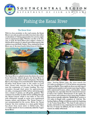
5 D e s P l a i n e s R i v e r B a s i n S u r v e yIntroductionThe Des Plaines River Basin provides a valuable and accessible resource for urban residents inNortheastern Illinois. These once highly degraded streams now support areas of diverse and sustainable fisheriesand have seen extensive restoration efforts including dam removals, channel restoration, as well as watershedbased planning and remediation efforts. As part of the Illinois Department of Natural Resources (IDNR) DamRemoval Initiative, nine of the 11 dams on the mainstem of the Des Plaines River have been removed to date.The remaining two dams upstream of the Brandon Road Lock and Dam (BRLD) are slated for removal in 2019,which will create over 96 miles of free flowing river, one of the longest in Northern Illinois. Three dams havebeen removed on the DuPage River system with additional dam removals and fish passage projects planned.Although water quality conditions have improved over the past 50 years, most of the Des Plaines Riverremains impaired for Aquatic Life, Recreation, and Fish Consumption (IEPA 2016). Recently, the Upper and LowerDes Plaines River Watershed Groups were formed to address water quality impairments. Watershed planning andresources monitoring are ongoing with financial support for the groups coming from Illinois EnvironmentalProtection Agency (IEPA).IDNR Division of Fisheries conducts fish surveys in the Des Plaines River Basin every five years as part of aStatewide Monitoring Program. In collaboration with the IEPA, the surveys also include macroinvertebrates,water quality, and habitat evaluation. Since 1983, five cooperative basin surveys with IEPA have been completedin the Des Plaines River Watershed. In addition, IDNR conducted fish surveys in 1974 (Langbein and Wright 1976)prior to initiation of the formal Basin Survey program in 1994. Other fish collections at select sites includedMuench (1968), Smith (1971), Heidinger (1989) and Day (1991). McClelland et al. (2004) reported on results oflong term fish monitoring on the lower Des Plaines River below BRLD. A recent publication from the IllinoisNatural History Survey also discussed historic condition of fish assemblages in the lower Des Plaines and IllinoisRiver Waterways, documenting improvements resulting from the Clean Water Act (Gibson-Reinemer et al. 2017).This report summarizes the fish sampling portion of the most recent Des Plaines River Basin Surveyconducted in 2018. In addition to describing current species composition, distribution and stream quality, resultswere compared to previous basin surveys over the past 44 years. We also examine sportfish populations anddiscuss potential factors influencing fish assemblages at mainstem and tributary locations.Study AreaThe Des Plaines River originates near Racine, Wisconsin in Kenosha County, entering Illinois two milesnorth of Rosecrans in Lake County. The river runs primarily south for 110 miles in Illinois where it joins theKankakee River to form the Illinois River, near Channahon (Figure 1). Total watershed area includesapproximately 2,110 square miles, 1,231 of which are in Illinois (Healy 1979). The drainage area was increased by673 square miles after diversion of Lake Michigan water through the Chicago Sanitary and Ship Canal (CSSC) andthe Cal Sag Channel in the early 1900's (MWRD 2018). The CSSC joins the Des Plaines River at river mile 17, justnorth of Joliet. A 16 mile section of the Des Plaines River, from approximately Romeoville to 47th Street, waschannelized as part of the CSSC Construction.The Des Plaines River is a low gradient stream falling 120 feet in elevation over its 110 mile length inIllinois, with an average slope of 1.2 feet/mile. Higher gradient areas are found in a short segment near Riversideand from Romeoville to the CSSC, where the gradient increases to nearly seven feet/mile.The DuPage River is the largest tributary to the Des Plaines River, with a watershed covering 353 squaremiles (Healy 1979), including urbanized areas of DuPage County. Other larger tributaries include Salt Creek, (150square miles), Hickory Creek (107 square miles), Jackson Creek (52 square miles) and Mill Creek (31 square miles).
6 D e s P l a i n e s R i v e r B a s i n S u r v e yThe Des Plaines River Watershed is very narrow, especially in the upper part of the basin, reaching less than eightmiles across at its narrowest point. Therefore, many of the upper tributaries are very short in length with smallwatershed areas ( 30 square miles).The watershed includes parts of Lake, Cook, DuPage, Grundy, and Will counties in Northeastern Illinois(Figure 2). With over 6 million people residing in the watershed, land use is 58.7% urban development with anadditional 33.2% in agriculture. By comparison, urban land use in the Fox River Basin is 17.5% and 3.5%statewide. Parts of the Des Plaines River Watershed, including Salt Creek, have very high density developmentand extensive urban land cover. Tributaries in the lower Des Plaines River Basin (Jackson and Hickory Creek) stillretain substantial agricultural land use.Figure 1. Map of the Des Plaines River Watershed including streams sampled in the 2018 Basin Survey and connection to the ChicagoSanitary and Ship Canal and Cal Sag Channel.The Des Plaines/DuPage River Watershed has a large number of wastewater treatment (n 85) and otherindustrial treatment facilities (n 66), which discharge 1,221 million gallons of wastewater per day into the streamsystem (IEPA 2016). Much of that flows into the lower watershed through the CSSC as municipal wastewater,
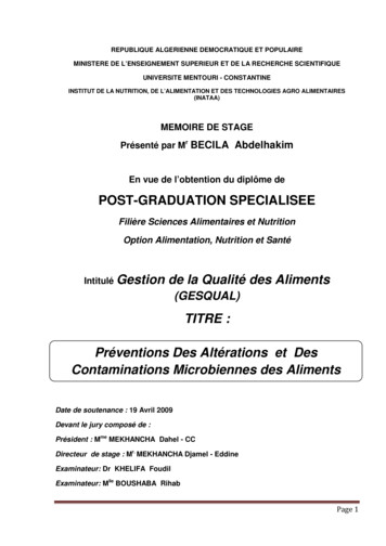
7 D e s P l a i n e s R i v e r B a s i n S u r v e yoriginating from Lake Michigan. Mean discharge at Romeoville, downstream of the CSSC, is 3,536 cubic feet persecond (cfs) for 739 square miles of watershed area, compared to mean discharge at Riverside of 535 cfs for 630square miles (USGS 2018). There are 51 combined sewer overflow (CSO) outlets along the Des Plaines Riverbetween O’Hare Airport and I-294 Bridge (MWRD 2018). The Tunnel and Reservoir Program (TARP) designed tocapture CSOs for subsequent treatment includes a 27 mile tunnel system under the Des Plaines River, completedin 1999 with a capacity of 405 million gallons. CSO events decreased after completion of the tunnel but were stillcommon until 2017 when McCook Reservoir came on line with additional capacity of 3.7 billion gallons whichreduced CSO events substantially.T NTT WT EST DEMPSTER ST. DAM (to be removed)T T TT T ##T TT T T TT TT T TT TT ISHR&TESNIINAASPLOSAGDEICHC#DuPage RiverT CHANNAHON DAM TT T 53óô#FAWELL DAMSHOREWOOD DAM (to be removed)TOUHY AVENUE DAM (to be removed)T T TTT PCMORTON ARBORETUM DAMLOCKPORT LOCK AND DAM (on CSSC)#T #T T T #T #0BRANDON ROAD LOCK & DAM50 MilesT T Brandon Road Lock and DamLowhead DamsDes Plaines River MainstemTributary StreamsChicago Sanitary and Ship CanalCountiesFigure 2. Dam locations in the Des Plaines River Basin. Lockport Lock and Dam is located on the Chicago Sanitary andShip Canal (CSSC).A total of 44 dams are listed for the Des Plaines River Watershed (Figure 2, USACE 2013). BRLD inRockdale is 2,391 wide and 35 feet tall, located 13 miles upstream from the Illinois River confluence (Figure 2). Aproposal to install an invasive fish barrier within the lock chamber has recently been approved to keep Asian Carpfrom swimming upstream to the Great Lakes (USACE 2019). The barrier will also block native fish migration.Upstream of Brandon Road, there were 11 low head dams, nine of which have been removed. Two additionaldams at Touhy and Devon Avenues are slated for removal in 2019. In the DuPage River Basin, three dams have
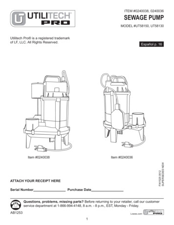
8 D e s P l a i n e s R i v e r B a s i n S u r v e ybeen removed in recent years, including two on the West Branch at McDowell Grove and Warrenville, and one onthe East Branch at Churchill Woods.The Des Plaines River Watershed includes 24 state nature preserves covering 5,850 acres, natural areastotaling over 13,000 acre and the Des Plaines State Conservation Area (4,600 acres), located near the confluencewith the Kankakee River. Forest Preserve Districts in Lake, Cook, DuPage, and Will Counties own over 300properties, many of which are in the Des Plaines River Watershed, including extensive areas along the mainstemof the Des Plaines and DuPage Rivers.Table 1. Location and collection information for 2018 Des Plaines River Basin Survey sampling stations; listed from upstream to downstream. BE Boat Electrofishing; ES ElectricSeine; PE Backpack Electrofishing.IEPA 8DES PLAINES RIVERDNS RUSSELL ROAD LAKE CO FPLAKEG-25*DES PLAINES RIVERWADSWORTH RD 90-87.9304207/17/2018BEG-07*DES PLAINES RIVERRT 120 /BELVIDERE RD BR W OF GURNEELAKE5042.343710-87.9409007/18/2018BEG-35*DES PLAINES RIVERDAN WRIGHT FOREST S PLAINES RIVER50DAM #2 WOODS COOK COUNTY FOREST PRSRVECOOK42.079842-87.8897817/19/2018BEG-3850DES PLAINES RIVERTOUHY AV PK RIDGECOOK42.010330-87.8613207/24/2018BE50G-15DES PLAINES RIVERIRVING PK RD IN SCHILLER PARKCOOK41.953060-87.8542007/24/2018BE60G-30DES PLAINES RIVERGRAND AV FRANKLIN PARKCOOK41.929580-87.8454707/24/2018BE60G-44DES PLAINES RIVERBETWEEN FOREST AVE AND 26TH STCOOK41.835989-87.8275009/26/2018BE45G-39*DES PLAINES RIVERRIVERSIDE/ LYONSCOOK41.825426-87.8184927/25/2018BE60G-18*DES PLAINES RIVERWILLOW SPRINGS RD COLUMBIA WOODSCOOK41.735450-87.8816607/19/2018BE50G-03DES PLAINES RIVERUS LEMONT RDCOOK41.681560-88.0022007/27/2018BE60G-02DES PLAINES RIVER135 ST AT ROMEOVILLE ISLE LA CACHE FPWILL41.640380-88.0715007/19/2018BE60G-11*DES PLAINES RIVERDIVISION ST BR AT S PLAINES RIVERDOWNSTREAM OF BRANDON RD LOCK AND DAMWILL41.500390-88.1037107/17/2018BE60G-01DES PLAINES RIVERI-55 BRIDGE 2 MI E MILL CREEKROLLINS SAVANAH FOREST ULL CREEKRT 21 MILWAUKEE AV LIBERTYVL LAKE CO FPLAKE42.313826-87.9621809/19/2018PE34GU-06INDIAN CREEK0.8 MILE N PRAIRIE VIEW AT VERNON TWP PKLAKE42.206722-87.9602289/19/2018ES53GL-01SALT CREEKYORK RD, 0.3 MI N OF OGDEN AVE 3FLAGG CREEKWALKER PK WOLF RD LA GRANGE 0.5 M S LL CREEKBLUFF RD WATRFAL GLEN FP DS RR ICKORY CREEK1 MI NE NEW LENOX DS MARLEY RDWILL41.523150-87.9428308/28/2018ES40GG-04HICKORY CREEKGAUGES RD 3 MI E JOLIET in PILCHER ON CREEKROWEL RD, 3.5MI NE NHATTAN CREEKDS W MANHATTAN RD BR, E RT 53WILL41.430000-88.0772229/21/2018PE40GBK-02W BR DUPAGE RIVER2 MI S 07W BR DUPAGE RIVERGARYS MILL RD WEST 7E BR DUPAGE RIVERSR 56 BR, HIDDEN LAKES FP DOWNERS GROVEDUPAGE41.831630-88.0476507/26/2018BE36GBL-19E BR DUPAGE RIVERROYCE RD, 0.1 MI W OF SR 53 -11DUPAGE RIVERRT 52 BRIDGE DUPAGE RIVEROLD RT 6 S MPLEMETHOD TIME (min)*Stations common to all Basin Surveys 1983 - 2018MethodsFish were sampled at 32 stations in 2018, including 16 stations on the Des Plaines River mainstem, 10 onDes Plaines River tributaries and six stations in the DuPage River watershed (Figure 3, Table 1). At wider, nonwadeable stations, fish were sampled using pulsed DC boat electrofishing. Seine hauls were also performed atboat sites where depth and structure allowed, using a 30-ft. long, 0.25-in. mesh minnow seine. Three hauls weremade in an upstream direction along the shoreline. Each haul was approximately 50-ft. in length. Seine data wasused only for species presence absence and was not include in other quantitative analyses. Wadeable tributarysites were sampled using a 30-ft. long electric seine powered by a single-phase, 2,000 watt AC generator (Bayley
9 D e s P l a i n e s R i v e r B a s i n S u r v e yet al. 1989). Collection dates and methods for each station are shown in Table 1. At all stations, larger fish andreadily identifiable specimens were identified, weighed (g), measured (mm) and returned to the stream alive.Smaller fish that were difficult to identify in the field were preserved in a 10% formalin solution for laboratoryanalysis. Sampling time for each station is shown in Table 1 and varied based stream width and habitatcomplexity. Stream width on the mainstem of the Des Plaines River ranged from 40 ft. at Wadsworth Road to300 ft. at I-55 Bridge. Tributary stations ranged from 10 to 70 ft. in width.ekMill Y##Y#LAK GBL-13#YA INP#LS YDE# YY#E BRDU PA GE#AGEUPAGEUPRDWB#YGBL-07RDWBE BRDU PA S#A IN YPL#SDE#YG-18#GK-03GJ-01G-02G-03#Y##WILL uPage RiverDuPage River#GB-11Hick ory CreekT # Brandon Lock and DamY##Y##GG-04GC-03GCA-01reekon CJacksG-01050 Miles50 MilesNN#Y#YDes Plaines River Mainstem2018 Des Plaines River Tributary Stations2018 Dupage River StationsTributary StreamsCountiesT #YWESBrandon road lock and dam.shp2018 Mainstem Sampling StationsDes Plaines River MainstemTributary StreamsCountiesWESFigure 3. Sampling station locations for Des Plaines River mainstem (A), Des Plaines River tributaries and DuPage River (B).Stream flows were near median daily levels during boat electrofishing sampling in July for the mainstemDes Plaines and DuPage River sites and were slightly elevated during tributary samples in late August andSeptember (based on the USGS gage at Riverside https://waterdata.usgs.gov/il/nwis/current/?type flow).We examined fish species composition, distribution and abundance of mainstem and tributary fishcollections. Non-metric multidimensional scaling (NMDS) was used to compare fish species composition amongsampling stations using Bray-Curtis (1957) similarity of square root transformed catch per unit effort (Kwak andPeterson 2007) using Primer 5 software. Separate analyses were run for mainstem and tributary stations. Analysisof sportfish populations included comparison of catch per unit effort (CPUE) and length frequency. Index of BioticIntegrity (IBI) scores were calculated for each station using protocols described by Smogor (2004). IBI evaluatesfish community attributes using 10 different metrics, each with a possible score of 0-6, with the grand totalranging from 0-60. Higher scores indicate better stream quality. Differences in IBI of 10 points are considered“biologically meaningful” (Smogor 2004).Results from the 2018 survey were compared to previous surveys in 1974, 1983, 1997, 2003, 2008 and2013. All stations were included for fish species presence/absence comparisons. For quantitative analyses ofcatch rates and IBI, only the six stations common to surveys from 1983 to 2018 were used (Table 1). IBI resultsamong years were compared for the six mainstem Des Plaines River locations common to all basin surveys using
10 D e s P l a i n e s R i v e r B a s i n S u r v e yANOVA (α 0.05) and t-test with Bonferroni Correction (α 0.008). NMDS was used to evaluate speciescomposition among all 2018 and prior years sampling stations using Bray-Curtis Similarity on square roottransformed CPUE. Scientific names for all fish species collected can be found in Table 2 and are not repeated inthe text or in other tables.Results and DiscussionWe collected 10,667 fish representing 15 families and 70 species at 32 stations in the Des Plaines RiverBasin in 2018 (Table 2). Hybrid taxa included Bluegill x Green Sunfish and Common Carp x Goldfish. Three Statelisted fish species were collected; the Threatened Banded Killifish and Iowa Darter and Endangered BlackchinShiner. Three non-native fish species were also collected: Common Carp, Goldfish and Round Goby. No AsianCarp species were collected or observed in 2018 or in any previous surveys. A total of 86 native species havebeen collected for all basin surveys combined from 1974 to 2018 (IDNR Database, 2018).Table 2. Family name, common name, scientific name, and total number of individuals for each fish species collected in the 2018 Des Plaines River Basin Survey; all 32 stations combined.FamilyCommon NameScientific NameLepisosteidaeLongnose GarLepisosteus osseus16AmiidaeBowfinAmia calva25ClupeidaeGizzard ShadDorosoma cepedianumCentral mudminnowUmbra limiGrass PickerelEsocidaeCyprinidaeCatostomidaeTotal No.FamilyCommon NameScientific NameIctaluridaeChannel CatfishIctalurus punctatus129Yellow BullheadAmeiurus natalis152Black BullheadAmeiurus melas165Brown BullheadAmeiurus nebulosusEsox americanus44Flathead CatfishPylodictis olivarisNorthern PikeEsox lucius44StonecatNoturus flavus12MuskellungeEs
Removal Initiative, nine of the 11 dams on the mainstem of the Des Plaines River have been removed to date. The remaining two dams upstream of the Brandon Road Lock and Dam (BRLD) are slated for removal in 2019, which will create over 96 miles of free flowing river, one of the longest in Northern Illinois. Three dams have