Transcription
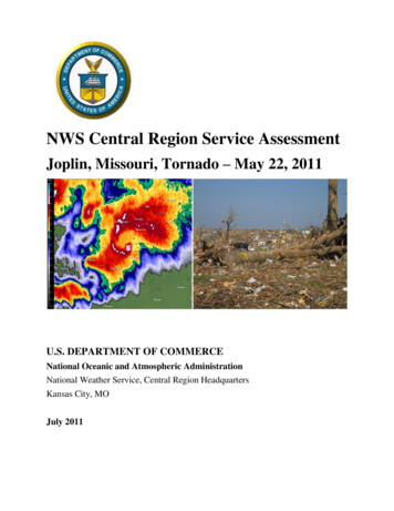
NWS Central Region Service AssessmentJoplin, Missouri, Tornado – May 22, 2011U.S. DEPARTMENT OF COMMERCENational Oceanic and Atmospheric AdministrationNational Weather Service, Central Region HeadquartersKansas City, MOJuly 2011
Cover PhotographsLeft: NOAA Radar image of Joplin Tornado. Right: Aftermath of Joplin, MO, tornado courtesyof Jennifer Spinney, Research Associate, University of Oklahoma, Social Science Woven intoMeteorology.
PrefaceOn May 22, 2011, one of the deadliest tornadoes in United States history struck Joplin,Missouri, directly killing 158 people and injuring over 1,000. The tornado, rated EF-5 on theEnhanced Fujita Scale, with maximum winds over 200 mph, affected a significant part of a citywith a population of more than 50,000 and a population density near 1,500 people per squaremile. As a result, the Joplin tornado was the first single tornado in the United States to result inover 100 fatalities since the Flint, Michigan, tornado of June 8, 1953.Because of the rarity and historical significance of this event, a regional Service Assessmentteam was formed to examine warning and forecast services provided by the National WeatherService. Furthermore, because of the large number of fatalities that resulted from a warnedtornado event, this Service Assessment will provide additional focus on dissemination,preparedness, and warning response within the community as they relate to NWS services.Service Assessments provide a valuable contribution to ongoing efforts by the National WeatherService to improve the quality, timeliness, and value of our products and services. Findings andrecommendations from this assessment will improve techniques, products, services, andinformation provided to our partners and the American public.Lynn P. MaximukDirector, Central RegionNational Weather ServiceJuly 2011ii
Executive SummaryOn May 22, 2011, one of the most devastating tornadoes in the nation’s history directly killed158 people and injured over 1,000 in Joplin, Missouri. From a National Weather Service (NWS)perspective, this was essentially a “warned” event in that advance notice of the tornado wasgiven, critical information was communicated and received, and most people sought the bestshelter available to them. The timely actions of the ”weather enterprise” (NWS, media,emergency management), and the eventual response of local businesses, churches, schools, andthe general public undoubtedly saved many lives.The NWS Springfield Weather Forecast Office was well prepared and performed in anexemplary manner in both its provision of services and its application of scientific expertise.The professionalism and dedication of the staff members is clearly a credit to the communitiesthey serve.Still, to learn what more can be done to help reduce fatalities from strong and violent tornadoes,the assessment team examined relevant issues ranging from internal NWS warning operations todissemination strategies to public warning response. To help accomplish this, nearly 100interviews were conducted in Joplin with tornado survivors, local businesses, media, emergencymanagement, NWS staff, city officials, and others.Many of the key findings within this report involved societal aspects of warning response andrisk perception. Responding to warnings is not a simple act of stimulus-response, rather it is anon-linear, multi-step, complex process. Relationships between false alarms, publiccomplacency, and warning credibility are highly complex as well.The majority of Joplin residents did not immediately take protective action upon receiving a firstindication of risk (usually via the local siren system), regardless of the source of the warning.Most first chose to further assess their risk by waiting for, actively seeking, and filteringadditional information before taking protective actions.The reasons for doing so were quite varied, but largely depended on an individual’s “worldview”formed mostly by previous experience with severe weather. Most importantly, the perceivedfrequency of siren activation in Joplin led the majority of survey participants to becomedesensitized or complacent to this method of warning. This suggests that initial siren activationsin Joplin (and severe weather warnings in general) have lost a degree of credibility for mostresidents – one of the most valued characteristics for successful risk communication.Instead, the majority of Joplin residents did not take protective action until processing additionalcredible confirmation of the threat and its magnitude from a non-routine, extraordinary risktrigger. This was generally achieved in different ways, including physical observation of theiii
tornado, seeing or hearing confirmation, and urgency of the threat on radio or television, and/orhearing a second, non-routine siren alert.This report suggests that in order to improve warning response and mitigate user complacency,the NWS should explore evolving the warning system to better support effective decisionmaking. This evolution should utilize a simple, impact-based, tiered information structure thatpromotes warning credibility and empowers individuals to quickly make appropriate decisions inthe face of adverse conditions. Such a system should:a. provide a non-routine warning mechanism that prompts people to take immediate life-savingaction in extreme events like strong and violent tornadoesb. be impact-based more than phenomenon-based for clarity on risk assessmentc. be compatible with NWS technological, scientific, and operational capabilitiesd. be compatible with external local warning systems and emerging mobile communicationstechnologye. be easily understood and calibrated by the public to facilitate decision makingf. maintain existing “probability of detection” for severe weather eventsg. diminish the perception of false alarms and their impacts on credibilityWhile the weather enterprise was generally successful in communicating the Joplin tornadothreat in a timely manner, current communication and delivery mechanisms are not seamless andare somewhat antiquated. Specifically, many warning dissemination systems are not fullycompatible with specific warning information provided by storm-based warning polygons—occasionally resulting in untimely gaps and confusion during dissemination. To improve thewarning dissemination system and provide a more coordinated warning message, the NWSshould continue to advance the development and cultivate the use of GPS-based mobilecommunications technologies and Emergency Alert System/NOAA Weather Radio upgrades.Last, an important impediment to heightening the urgency of the severe weather message fromthe Weather Forecast Office was the WSR-88D Volume Coverage Pattern strategies available toforecasters. Low level rotational intensification and tornado genesis occurred very rapidly as thestorm approached Joplin. Limited scans (every 5 minutes) at the lowest elevations slices likelyimpacted the WFO ability to quickly ascertain the magnitude of the event. To enhance theability to monitor rapid tornado genesis, the NWS should develop and implement additionalVolume Coverage Pattern strategies that allow for more continuous sampling near the surface(e.g., 1-minute lowest elevation sampling).iv
Table of ContentsIntroduction and Background .1Societal Aspects of Risk Perception and Warning Response .3Methodology .4Risk Signals: Receiving and Understanding the Warning .4Perception, Processing and Personalizing the Threat .6Triggers for Decisions to Act .7Taking Protective Actions .9Conclusions .10Warning Communications, Dissemination, and Community Preparedness .11Storm-Based Warnings and Local Warning Dissemination Systems .11NWSChat as a Coordination Tool .14Community Preparedness .14WFO Springfield Products and Services .15Storm Prediction Center (SPC) Products and Services .18WFO Springfield Warning Operations .20AppendicesAppendix A: Radar Imagery .24Appendix B: Upper Air Observations .27Appendix C: Operational Enhanced Fujita (EF) Scale .28Appendix D: Findings, Recommendations, and Best Practices .29Appendix E: Acronyms .33Appendix F: Assessment Team Members .34Appendix G: Errata .35v
1. Introduction and BackgroundOn May 22, 2011, one of the most devastating tornadoes in the nation’s history directly killed1581 people and injured over 1,000 in Joplin, Missouri. The Joplin tornado was the first singletornado to result in over 100 fatalities since the June 8, 1953, Flint, Michigan tornado.The tornado was rated EF-5 on the Enhanced-Fujita Scale, with its maximum winds estimated atmore than 200 mph. The path of the entire tornado was 22.1 miles long and was up to 1 mile inwidth. The EF-4/EF-5 damage path was roughly 6 miles long from near Schifferdecker Avenuealong the western portions of Joplin to near Interstate 44 east of Joplin, and generally ½ to ¾ of amile wide along the path (Figure 1).Figure 1: Storm Track and Intensities for May 22, 2011, Joplin TornadoBecause this was a warned event with an unusually high number of fatalities, this ServiceAssessment was initiated for the primary purpose of learning what more could be done to furtherlimit fatalities and injuries from EF-4/EF-5 tornadoes. To this end, the assessment focus was oncommunication, dissemination, community preparedness, and the public warning responseleading into and during the event. The assessment team interviewed over 60 survivors; localemergency management for Joplin and surrounding areas; local print, radio, and televisionmedia; NWS employees; Joplin city officials; fire and law enforcement dispatchers; andemployees and patrons from area businesses, schools, and hospitals. In total, this was nearly 1001As of the date of this report, there were 158 direct fatalities and 4 indirect fatalities.
interviews. This report attempts to synthesize the most common responses, and occasionallyhighlight other responses that offer important insights.Not surprisingly, there was a full spectrum of responses on most key interview points, especiallyon issues concerning how people perceived and responded to warnings. For example, somepeople took shelter in appropriate locations, but did not survive. Others mistakenly drove theirvehicles into the tornado path, but somehow lived to tell of it.Also, while these interviews and the assessment efforts sought insights on how to reduce violenttornado fatalities, it is worth noting that the actions of the “weather enterprise”2, local businesses,churches, schools, and the general public undoubtedly saved many lives on May 22, 2011.Generally speaking, advance warning of the tornado was given, information was communicatedand received, and most people sought the best shelter available to them. It is difficult to quantifythese impacts and place them in historical context with other comparable tornadoes.Several key decision points along the warning and response timeline are referred to throughoutthis report. As background, these are listed below in Table 1, Figure 2 (tornado warningpolygons) and Appendix A (radar observations).130 pm CDT – NWS/SPC Tornado Watch issued for Southwest Missouri in effect until 900pm CDT509 pm CDT - WFO Springfield Tornado Warning Polygon #30 issued for Western JasperCounty MO (including northeastern Joplin) in effect until 600 pm CDT511 pm CDT – Initial 3 minute siren alert sounded for Jasper County and Joplin517 pm CDT – WFO Springfield Tornado Warning Polygon #31 issued for southwestJasper County MO (and Joplin), northwest Newton County MO and southeast CherokeeCounty (KS) in effect until 600 pm CDT534 pm CDT – Approximate initial Tornado touchdown ½ mile southwest of JJ Highwayand Newton Road (southwest of Joplin City limits)538 pm CDT – Second 3 minute siren alert sounded for Jasper County and Joplin. EF-4Damage begins as tornado approaches Schifferdecker Avenue in western Joplin548 pm CDT – WFO Springfield Tornado Warning Polygon #32 issued for southern JasperCounty MO (including Joplin), northern Newton County MO and western LawrenceCounty MO in effect until 630 pm CDT2Throughout this report, “weather enterprise-’” refers collectively to NWS, media, and emergency management.2
Table 1: Key Timeline of Events for Joplin Tornado EventFigure 2: Tornado Warning polygons prior to and during the Joplin tornado and thetornado damage path2. Societal Aspects of Risk Perception andWarning ResponseA major portion of the Joplin Tornado Service Assessment was dedicated to understanding thesocietal response to NWS warnings and external local warning systems. The ServiceAssessment team went to Joplin, Missouri, between June 7-9, 2011, to interview residents abouthow they received, processed, and responded to the warnings leading up to the May 22 tornado.Finding #1: Recent NWS Assessments have addressed societal impacts of warnings, mostnotably the “Super Tuesday Tornado Outbreak of Feb. 5-6, 2008” and the “Mother’s DayWeekend Tornado Outbreak of 2008.” Many of the societal impacts uncovered in previousService Assessments were also evident in Joplin, suggesting the NWS should take a moreaggressive stance in addressing warning response.Recommendation #1: For future Service Assessments, NWS should plan a more structuredapproach to collecting information on societal aspects of warning response. This should includedeveloping sub-teams well-versed in social science and NWS warning operations that can be3
quickly deployed to the field following any given severe weather disaster.a. METHODOLOGYIn order to meet the Assessment objectives, the team utilized ethnographic methods ortechniques commonly used by social scientists to scientifically describe cultures and the peoplewithin these cultures3. In particular, the team strove to understand residents’ points of viewsregarding the process of warning reception to warning response, and how decisions were made.The team carried out a series4 of semi-structured interviews with residents and local businesses:in-person, over the phone, or in group settings. Semi-structured interviewing is a method ofinquiry based on the use of an interview guide to provide consistency between interviewers,providing a menu of questions or topics that need to be covered in a particular order. Thismethod is useful in situations where interviewers have only one opportunity to conduct aninterview. Questions for this Assessment were formulated in such a way as to minimize theinfluence of the interviewer and, perhaps most importantly, to allow each person to define thecontent of the discussion they felt was important.The findings in this Service Assessment represent a local case study, meaning that the societalresponses to warnings that are described in this Assessment are meant to reflect the trendspresent in this particular sample. Because of limited sample size and distribution, interviewresponses are largely characterized in general terms, and occasionally in specific terms tohighlight useful insights.b. RISK SIGNALS: RECEIVING AND UNDERSTANDING THE WARNINGResponse to severe weather warnings is a complex, non-linear process depending on perceptionof risk. Perception of risk is influenced first and foremost by the method in which the risk iscommunicated. The warnings, or risk signals5, that aroused Joplin residents’ attention, promptedtheir belief in the threat of the tornado and informed their decisions to act included, in noparticular order: Broadcasts made on television and radio; NWS watches and warnings obtainedvia commercial and government web pages; the activation and deactivation of the 1st siren; theactivation of the 2nd siren; text messages; posts to social media networking sites; informationtransmitted over NOAA Weather Radio (NWR); observations of the physical environment;3Spradley, James P. (1979) The ethnographic interview. New York: Holt, Rinehart and Winston (17)4The results shared in this section of the report are based on the perspectives of 54 residents of Joplin. Nine of the63 interviews were not included because they were either second-hand accounts, wind interfered with the audiorecording, or the interview did not contain relevant data.5Kasperson, Jeanne X., Roger E. Kasperson, Nick Pidgeon, and Paul Slovic (2003). The social amplification of risk:assessing fifteen years of research and theory. In The Social Amplification of Risk. N. Pidgeon, R. E. Kasperson andP. Slovic. (eds). Cambridge, UK: Cambridge University Press. Pp. 13-46.4
messages from family, friends, neighbors, and coworkers. Each of these signals, independentlyor in combination, were processed in varying ways over differing amounts of time, heighteningor diminishing perceptions of threat.Finding #2a: For the majority of surveyed Joplin residents, the first risk signal for an imminentsevere weather threat came via the local community siren system. As a result, there was asignificant degree of ambiguity associated with the first alert regarding the magnitude of therisk, the seriousness of the warning, and its potential impact.This did not necessarily mean that residents exclusively relied on these systems for their weatherinformation, only that the sirens were their first indication of a risk.In Joplin, it is community policy to sound sirens when either a tornado is reported to be movingtoward Joplin or severe thunderstorm winds are expected to exceed 75 mph. These triggers mayor may not be associated with an NWS warning, and the Jasper County/Joplin EmergencyManager has discretion and uses professional judgment on when to activate sirens. These typesof local warning system policies are by no means unique to Joplin.Once the decision is made to activate sirens, they are sounded in one 3-minute burst and thenshut off. For those that used the sirens as the initial alert tool, there was no way to immediatelydiscern the magnitude and nature of the threat nor its potential impact. This lack of informationmakes it difficult for warning recipients to calibrate the severity of the situation, thus delayingtheir response. Also, several of those interviewed expressed confusion associated with thesingle 3-minute siren alert, thinking the threat was over once the sirens had ceased.Conceptually, warnings could be defined broadly as the number and combination of risk signalseach person received and processed prior to their decision to take protective action.The interviews indicated that individuals received anywhere between two and nine risk signalsfrom the time they were aware of the possibility of severe weather to the time they engaged inprotective action. This drastic difference is explained by a) the differing lengths of time thatpassed from first indication of threat to taking protective action, b) the differing ways individualsreceived risk signals and interpreted the situation as threatening, and c) the effect of conflictingrisk signals.The number of signals between first indication of severe weather and protective action markedlyincreased as information became conflicted or unclear. In the most extreme example, oneresident’s interview indicated nine risk signals identified before taking protective action:1.2.3.4.5.Aware that thunderstorms were probably going to happenNoticed the weather changing outsideHeard the 1st siren while driving to restaurant (approximately 30-minute lead time)Restaurant shut doors and disallowed entryDrove to a 2nd restaurant where business was carrying on as usual5
6.7.8.9.Noticed the weather changingReports came from TV and radioPatron indicated tornado in JoplinManagement instructed protective actionIn this example, signals 4 and 5 are significant in that they heightened and diminished thisresident’s perception of risk, respectively. Once the restaurant shut its doors and refused entry,this resident perceived the threat of severe weather as real and commented during the interviewthat he did not want to be in his car. Upon arriving at another restaurant close by, however, hisperception of threat was diminished because business at this second establishment was carryingon as normal. He was escorted to a table and ordered a meal.c. PERCEPTION, PROCESSING AND PERSONALIZING THE THREATFinding #2b: The majority of surveyed Joplin residents did not immediately go to shelter uponhearing the initial warning, whether from local warning sirens, television, NWR, or othersources. Instead, most chose to further clarify and assess their risk by waiting for, activelyseeking, and filtering additional information.In order to gain a sense for how social models of understanding influenced perceptions of riskand warning response, particular attention was paid to the “worldviews” held by residents.Worldview6 is defined as an overall perspective of how people interpret their environment or theworld around them – and is generally informed by things like one’s experience, education, andcultural values.Interviews showed aspects of worldview that influenced risk perception and warning responseincluded: Previous experiences with tornadoes; apathy; familiarity with seasonal weatherpatterns in southwest Missouri; optimism bias; perceived frequency of siren activation in Joplin;social networks as mechanisms for warning dissemination; avid fear of tornadoes, and thenumber of deadly tornadoes earlier in the year.Previous experiences with tornadoes were shown to have an influence in the way residentsperceived their risk and responded to the warnings. As one resident indicated, the tornado heexperienced prepared him mentally for appropriate response action during this event. Anotherresident commented that time spent in Oklahoma City made him complacent to the possibility ofa tornado in Joplin.Similarly, familiarity with seasonal weather in southwest Missouri played a major role in risk6Roncoli, Carla, Keith Ingram, Christine Jost and Paul Kirshen (2003) “Meteorological Meanings: Farmer’sinterpretation of seasonal rainfall forecasts in Burkina, Faso.” In Weather, climate, culture. S. Strauss and B. Orlove(eds). Oxford; New York: Berghahn Books. Pp. 181-200.6
perception and warning response. Most individuals commented that severe weather in southwestMissouri during spring is common; however, tornadoes never affect Joplin or themselvespersonally. It was common in the interviews to hear residents refer to “storms always blowingover and missing Joplin,” or that there seemed like there was a “protective bubble” aroundJoplin, or “there is rotation all the time, but never in Joplin”. One city employee stated, “ don’t think it can’t happen in your community, because that’s what I thought”. This sense inwhich people believe their personal risk from a hazard is less than the risk faced by others isreferred to as optimism bias and can lead to diminished perceptions of threat and influenceresponse.Although not as common, social networks as mechanisms for warning dissemination were foundto generally amplify perceptions of risk and lead to warning response. For example, one womanreported eating dinner with family, receiving a text message about the tornado, and thenreceiving a phone call shortly after informing her of a storm travelling through Joplin. Thisheightened the woman’s belief that a threat existed and prompted her and her family members totake shelter at the restaurant.Similar to seasonal weather patterns, the perceived frequency of siren activation (false alarms)led a large number of participants to become desensitized or complacent to this method ofwarning. Many noted that they “hear sirens all the time and [sirens] go off for dark clouds,” theyare “bombarded with [sirens] so often that we don’t pay attention”, “the sirens have gone off somany times before,” “sirens are sounded even for thunderstorms,” and “all sirens mean is there isa little more water in the gutter”.The diminished severity or absence of a threat (complacency) held by Joplin residents can beunderstood as resulting from their normalization of the threat. Normalized responses towardsevere impacts are likely to occur in groups frequently exposed to hazardous weather7. The samecould be said for residents in Joplin who, based on their perceived frequent exposure to localwarning systems (and NWS warnings) during spring, normalized their reactions to the activationof the first siren and characterized it as just another aspect of springtime in Joplin.Finding #2c: Familiarity with severe weather and the perceived frequency of siren activationnot only reflect normalization of threat and/or desensitization to sirens and warnings, but theyalso establish that initial siren activation has lost a degree of credibility for many residents.Credibility is considered to be one of the most valued characteristics for effective riskcommunication8.7Bankoff, Greg (2007) ‘Living with risk; coping with disasters: hazard as frequent life experience in thePhilippines’. Education about Asia. 12(2): 26-298Trumbo, Craig W., and Katherine A. McComas (2003) “The functionality of credibility in information processingfor risk perception.” Risk Analysis 23(2): 343-353.7
It should be noted that stakeholders in the warning process, such as media or EmergencyManagers, were less likely to think over-warning or desensitization to NWS warnings was anissue. During interviews, Emergency Managers in particular felt the frequency of warnings wasappropriate, while media staff were split with some saying “most warnings were ‘cry wolf,’”,while others emphasized the importance of advance warning for all tornadoes regardless of falsealarms. In general, these groups have a sense of obligation for the safety of their constituentswhich influences their worldview of the warning process and risk perception.TRIGGERS FOR DECISIONS TO ACTThough risk signals tended to elevate awareness, there were certain signals that stood out, addedimportant credibility to the warning, and acted as triggers in prompting a belief in the threat andtaking protective action.Finding #2d: The majority of surveyed Joplin residents did not take protective action untilreceiving and processing additional, credible confirmation of the threat and its magnitude froma non-routine trigger.While searching for additional information concerning the severe weather threat constitutes“taking an action,” the actions many residents described taking were not the immediate lifesaving measures desired with the issuance of a tornado warning. In most cases, these life-savingactions, or the decision to find shelter, were associated with additional extraordinary risk signals.This was generally achieved in different ways, including:a. Physical observation of the environment (seeing the tornado approach).While significant numbers of people actually did this, the approach was complicated byhaving a “rain-wrapped” tornado that made the tornado more difficult to recognize until itwas very close. There were numerous accounts of people running to shelter in theirhomes just as the tornado struck, despite significant advance warning of the risk.b. Seeing or hearing confirmation of the threat on radio or television, seeing the largetornado on the air, or hearing on-air instructions to “take cover now.”When the tornado began moving into Joplin most local electronic media switched to“wall-to-wall” coverage of the event, including live video from tower-cams. As coveragequickly evolved, and the magnitude of the event became clear, on-air commentatorsimplored those in the path to take cover immediately. This kind of media coveragehelped convey the seriousness and urgency of the situation, and prompted many listeners8
and viewers to find shelter.c. Hearing a second, non-routine, siren alert at approximately 538 pm CDT.It is the Joplin emergency management policy to sound the sirens one time for a severeweather alert. Because of the length of time that had elapsed since the initial siren alert,and as reports came into central dispatch of a tornado moving into Joplin, the EmergencyManager made the decision to activate the local warning sirens a second time. Thissecond siren activation came about 20 minutes after WFO Springfield issued the TornadoWarning (TO.31) for southwestern Jasper County, including Joplin (issu
the NWS should explore evolving the warning system to better support effective decision making. This evolution should utilize a simple, impact-based, tiered information structure that promotes warning credibility and empowers individuals to quickly make appropriate decisions in the face of adverse conditions. Such a system should: