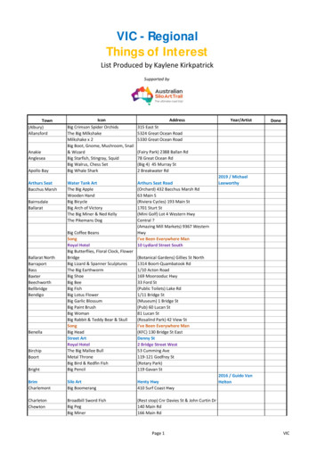
Transcription
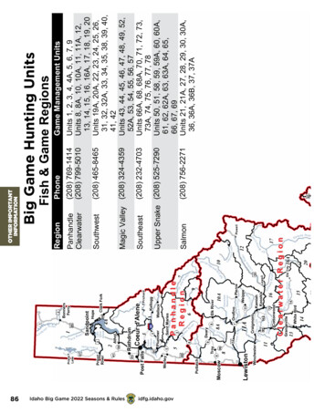
k Forkarie3St Joeve8DearyrtlPoo C reiSelwR i verLowellayeCl12NFLosa16AcheRi vCa10Units 1, 2, 3, 4, 4A, 5, 6, 7, 9Units 8, 8A, 10, 10A, 11, 11A, 12,13, 14, 15, 16, 16A, 17, 18, 19, 20Units 19A, 20A, 22, 23, 24, 25, 26,31, 32, 32A, 33, 34, 35, 38, 39, 40,41, 42Units 43, 44, 45, 46, 47, 48, 49, 52,52A, 53, 54, 55, 56, 57Units 66A, 68, 68A, 70, 71, 72, 73,73A, 74, 75, 76, 77, 78Units 50, 51, 58, 59, 59A, 60, 60A,61, 62, 62A, 63, 63A, 64, 65,66, 67, 69Units 21, 21A, 27, 28, 29, 30, 30A,36, 36A, 36B, 37, 37A(208) 769-1414(208) 799-5010(208) 41915le arw a ter R iv er14Salmo n R iveWhite BirdGrangevilleElk City20(208) 232-4703oo s12re17eCe21PowellSalmon93NorthFork(208) 756-2271Upper Snake (208) 525-7290SoutheastMagic Valley (208) 324-4359Game Management UnitsPhoneRegionFish & Game RegionsOTHER IMPORTANTINFORMATIONBigBigGameHuntingUnitsGame Hunting Unitsyus e C ree kerC l e a r Fw a t e r R e g i o nCCottonwood16KamiahKooskia95162Cre e kC o tt on w oo d13wy er Cre ekPierce9WeippeCre ek11LolO ro finoOrofinoDworshakReservoir10AElk RiverCraigmont11A78A6PanhandleR e g i o n R v7MerSt90Saint MariesPlummer33a r w a t erR iv erC le99HopeCoeur endOreilleAthol2Potlatch P a l o use R iv95Worley542Pries t RiverRathdrumPost verch RiatPriestLakeiiekidfg.idaho.govRR ivIdaho Big Game 2022 Seasons & RulessterPa c kerR iva rwaRi v e rM86akKnteooEFerSelw ay River
deCascadeReservoir24McCallE953284PaMurphyran C e425245LakeLowellowWarm Lake78reep eau84reCreloolPoisCtHC am a sCPa Shoup2829Tendoy2830Salmon21ANorthForker Crek26W48o odFairfieldR7552RstL it75tleWo2437Aekn46Cree k30ru R iveekSFek47BuhlA50pe52Ae lont54273025582822Oakleyve rRi5577Albion86AmericanFallsReservoir845739di cne59AMedg22LoeCr5915Cr60AasDuboisSpencerr3770fo oSn a k e RiveBlackfoot91r tnell lackfootReservoir66AGrays LakePalisadesReservoir663165VictorSwan Valley67Tetonia3362Ashton32RTe t on i ve64 33RexburgwC62A47Saint AnthonyeRigbyBe d20akSnR ivIsland Park2073A38MaladCity7315369174kR o ck C r eekonid ga rbOwyh outheast Regionru f Inkom60Island ParkReservoir6187Idaho Falls63ADryShelley483371PocatelloFo rk2030 PoRo s s68A2663Mud LakeAmerican ley53 RupertTwin FallsreekRogerson93FilerJerome935130A29U p p e r S n a k e R e g i o nk93Mackayive rPicaboBellevue49HaileygLo37Sun Valley36A75imChallisGooding Shoshone46C a m a s C r ee k444375Stanley3636B93LeadoreMagic Vall ey Regi onHagermani lo27BlissC l ov eon2193Salmon RegionAtlantark45Mountain Home20isRivereRoiseFolmSaekCe da r C reekC J StrikeReservoir67onBoiseBi greCeeBkGrandView38kIdaho City39CrBNFle26Bi g C r e20A2135re eyhMeridians34rRi veS F P a y etteLowmanee33Horseshoe Bend55Nampa16Silver City40wS qu aEmmettt t e R iv er55yelBig W ilCaldwell203095WeiserFruitlanddJ orkCre eeeCrDetleIdaho Big Game 2022 Seasons & RulesB luatekCr eJ ac k20Yellow PineF S F Sa lm o n2519Ar1915Salmo n R iveriveeR18RiverLittle Sa lm onWhite BirdJo hn s on Cre ekSouthwest Region3122BrownleeReservoireisWrveR ive rn earCvekCMLoP a y et tRive rRireekConNFMFP ayet teeorMnyCaSuga r CreekrveCkreeoca rysCSaRCadmrkpBiid dMaDeFoeeCreSou thMars heRShEriv el moFSave rerSF Sa lmonreekBr uerreekR ivDee p Cre ekrs e Cr eekrR iv ereeknRrRiviv etIveBkla cRareRR afRrBeDee pSFiseBoGetee kB igaktl eCriveeekOBanno ckivrrCre ektRveodroserRiGo oLLit t l erSalm o n Falls C re e kiveidfg.idaho.govOTHER IMPORTANTINFORMATIONC re e kMa n nvekR iverRichCamB irekC reFolw ay RiverreekhsoiikryskPaereeeer Cre eka veBeH enre evererrChi RiWarmSeent hL emerkDevil C ree kC re ekriv eJOwr87
UNIT BOUNDARY DESCRIPTIONSUnit 1— All of BOUNDARY COUNTY and that portion ofBONNER COUNTY north of the Pend Oreille River, Pend OreilleLake and Clark Fork River.Unit 2—Those portions of BONNER and KOOTENAICOUNTIES within the following boundary: beginning at theintersection of the Idaho-Washington State line and the north bankof the Pend Oreille River, then east along the Pend Oreille River toPend Oreille Lake at the railroad trestle in the southeast corner of theCity of Sandpoint, then south across the railroad trestle, then east andsouth along the western shoreline of Pend Oreille Lake to the southboundary of Farragut State Park, then west along the boundary toState Highway 54 at Farragut State Park west entrance, then west onState Highway 54 to U.S. 95, then south on U.S. 95 to Lake Coeurd'Alene at the Spokane River source, then west along the southernbank of the Spokane River to the Idaho-Washington State line, thennorth along the state line to the point of beginning.Unit 3—Those portions of KOOTENAI, SHOSHONE, andBENEWAH COUNTIES within the following boundary: beginningat Mission Point on the St. Joe River and State Highway 3, thennortheast on State Highway 3 to Interstate 90, then east on Interstate90 to Kingston, then north on Forest Highway 9 (North Fork of theCoeur d'Alene River Road) to Forest Service Road 209 (Little NorthFork of the Coeur d'Alene River Road), then northwest along ForestService Road 209 then north along Forest Road 385 to the watersheddivide between the Coeur d'Alene River and Pend Oreille Lake, thennorthwest along the divide to Bernard Peak, then north to SteamboatRock on Pend Oreille Lake, then west along the lake shore to thesouth boundary of Farragut State Park, then west along the boundaryto State Highway 54 at the west entrance of Farragut State Park, thenwest on State Highway 54 to U.S. 95, then south on U.S. 95 to Coeurd'Alene Lake, then southeast along the eastern shoreline of Coeurd'Alene and Round Lakes to the point of beginning.Unit 4—Those portions of BONNER, KOOTENAI, andSHOSHONE COUNTIES within the following boundary: beginningon the Idaho-Montana State line at the watershed divide betweenPend Oreille Lake and the Coeur d'Alene River, then southeast alongthe state line to the watershed divide between the Coeur d'Alene andSt. Joe Rivers, then west along the divide to State Highway 3, thennortheast on State Highway 3 to Interstate 90, then east on Interstate90 to Kingston, then north on Forest Highway 9 (North Fork of theCoeur d'Alene River Road) to Forest Service Road 209 (Little NorthFork of the Coeur d'Alene River Road), then northwest along ForestService Road 209 then north along Forest Road 385 to the watersheddivide between the Coeur d'Alene River and Pend Oreille Lake, thennortheast along the divide to the point of beginning.Unit 4A— Those portions of BONNER and KOOTENAICOUNTIES within the following boundary: beginning on the IdahoMontana State line at the watershed divide between Pend OreilleLake and the Coeur d'Alene River, then southwest along the divide toBernard Peak, then north to Steamboat Rock on Pend Oreille Lake,then northwest along the western shoreline of Pend Oreille Lake tothe railroad trestle approximately one (1) mile south of Sandpoint,then north on the railroad trestle to Sandpoint, then east along thenorth banks of Pend Oreille Lake and the Clark Fork River to theIdaho-Montana State line, then south on the state line to the point ofbeginning.88Idaho Big Game 2022 Seasons & RulesUnit 5—Those portions of BENEWAH and KOOTENAICOUNTIES within the following boundary: beginning at theintersection of the Idaho-Washington State line and the SpokaneRiver, then east along the southern bank of the Spokane River toU.S. 95 at Coeur d'Alene Lake, then southeast along the easternshoreline of Coeur d'Alene and Round Lakes to Mission Point, thenupstream along the northern bank of the St. Joe River to the mouthof St. Maries River, then upstream along the St. Maries River tothe intersection of the St. Maries River and State Highway 3 nearMashburn, then south on State Highway 3 to the intersection of StateHighway 6, then southwest on State Highway 6 to the watersheddivide between the St. Maries and Palouse Rivers, then northwestalong the divide to West Dennis Peak, then west along the watersheddivide between Hangman Creek and Palouse River to the IdahoWashington State line, then north along the state line to the point ofbeginning.Unit 6—Those portions of KOOTENAI, SHOSHONE,BENEWAH, CLEARWATER, and LATAH COUNTIES withinthe following boundary: beginning at St. Maries, then downstreamalong the northern bank of the St. Joe River to Mission Point onState Highway 3, then north on State Highway 3 to the watersheddivide between the St. Joe and Coeur d'Alene Rivers, then east alongthe divide to Moon Pass Road, then south on Moon Pass Road toMilwaukee Road in Avery, then west on Milwaukee Road and SibertsOld River Road to Fishhook Creek Road (Forest Service Road 301),then south on Fishhook Creek Road to Breezy Saddle, then southweston Forest Service Road 301 to White Rock Springs, then south alongthe watershed divide between the St. Maries River and Little NorthFork of the Clearwater River over Stony Butte to Hemlock Butte,then northwest along the St. Maries River-Potlatch River watersheddivide across Bald Mountain to State Highway 6, then northeast onState Highway 6 to the intersection of State Highway 3, then northon State Highway 3 to the St. Maries River, then downstream to thepoint of beginning.Unit 7—That portion of SHOSHONE COUNTY within thefollowing boundary: beginning on the Idaho-Montana State line atthe watershed divide between the St. Joe and Coeur d'Alene Rivers,then west along the divide to Moon Pass Road, then south on MoonPass Road to Milwaukee Road in Avery, then west on MilwaukeeRoad and Siberts Old River Road to Fishhook Creek Road (ForestService Road 301), then south on Fishhook Creek Road to ForestService Road 201, then east on Forest Service Road 201 to BluffCreek Saddle (Dismal Saddle), then southeast past Dismal Lake andBathtub Springs to the watershed divide between the St. Joe andNorth Fork of the Clearwater Rivers, then east along the divide to theIdaho-Montana State line, then north along the state line to the pointof beginning.Unit 8—Those portions of LATAH, NEZ PERCE, andCLEARWATER COUNTIES within the following boundary:Beginning on the Idaho-Washington state line at the watersheddivide between Hangman Creek and Palouse River, south alongthe divide to U.S. 95, then south along U.S. 95 to State Highway 6,then east along State Highway 6 to State Highway 9, then southeastalong State Highway 9 to Deary, then south on State Highway 3 toKendrick, then southeast along County Road P-1 through Southwickand Cavendish to the North Fork of the Clearwater River at Ahsahka,then downstream along the North Fork of the Clearwater River to itsidfg.idaho.gov
junction with the main Clearwater River including islands, then downthe main Clearwater River to the Idaho-Washington state line, thennorth along the state line to the point of beginning.Unit 8A—Those portions of BENEWAH, LATAH,CLEARWATER, and NEZ PERCE COUNTIES within the followingboundary: Beginning at Ahsahka on County Road P-1, thennorthwest along County Road P-1 through Southwick and Cavendishto State Highway 3, then northeast along State Highway 3 to Deary,then northwest along State Highway 9 to State Highway 6, then westalong State Highway 6 to U.S. 95, then north along U.S. 95 to thewatershed divide between Hangman Creek and Palouse River, thensoutheast along the divide to West Dennis Mountain, then southeastalong the St. Maries watershed divide to Hemlock Butte, then southon Elk Creek Road (Forest Service Road 382) to Elk River, thensouth on the Dent Bridge-Elk River Road to the south shoreline ofDworshak Reservoir, then along the southern shoreline to DworshakDam, then downstream along the North Fork of the Clearwater River(excluding islands) to the point of beginning.Unit 10—Those portions of SHOSHONE, CLEARWATER, andIDAHO COUNTIES within the following boundary: beginning atthe confluence of the Little North Fork and the North Fork of theClearwater Rivers at the upstream end of Dworshak Reservoir, thenup the east shoreline of the reservoir and the Little North Fork of theClearwater River to the watershed divide between Bear and DevilsClub Creeks, then east along the divide to the watershed dividebetween the Little North Fork and the North Fork of the ClearwaterRivers, then east along the divide to the watershed divide betweenthe North Fork of the Clearwater and the St. Joe Rivers, then eastalong the divide to the Idaho-Montana State line, then south along thestate line to the divide between the North Fork of the Clearwater andthe Lochsa Rivers, then west along the divide over Williams Peak toits intersection with the Lolo Motorway (Forest Service Road 500),then west on Lolo Motorway to its intersection with Hemlock ButteRoad (Forest Service Road 104), then northwest on Hemlock ButteRoad to Hemlock Butte and the watershed divide between Weitas andOrogrande Creeks, then north along the divide to Cabin Point thennorthwest along Forest Service Trail 17 to the North Fork ClearwaterRiver then downstream along the North Fork of the ClearwaterRiver and the north shoreline of Dworshak Reservoir to the point ofbeginning.Unit 10A—Those portions of SHOSHONE, IDAHO andCLEARWATER COUNTIES within the following boundary:beginning at the mouth of the North Fork of the Clearwater Riveralong the southern shoreline, upstream to Dworshak Dam, then upDworshak Reservoir along the southern shoreline to Dent Bridge,then north on Elk River Road to Elk River, then north on Elk CreekUnit 11—Those portions of NEZ PERCE, LEWIS, and IDAHOCOUNTIES within the following boundary: beginning at the mouthof the Clearwater River, upstream to U.S. 95 bridge near Spalding,then southeast on U.S. 95 to Graves Creek Road at Cottonwood,then south on Graves Creek Road to the Salmon River, thendownstream to the Snake River, then downstream to the point ofbeginning.Unit 11A—Those portions of CLEARWATER, NEZ PERCE,LEWIS, and IDAHO COUNTIES within the following boundary:beginning on the Clearwater River at the U.S. 95 bridge nearSpalding, upstream (excluding islands) to the South Fork of theClearwater River, then up the South Fork to Harpster Grade Bridge,then southwest on State Highway 13 to U.S. 95 at Grangeville, thennorthwest on U.S. 95 to the point of beginning.Unit 12—Those portions of IDAHO and CLEARWATERCOUNTIES within the following boundary: beginning at thejunction of Smith Creek Road (Forest Service Road 101) and theMiddle Fork of the Clearwater River, then northeast on Smith CreekRoad to Lolo Motorway (Forest Service Road 500), then northalong Lolo Motorway to the point where it leaves the watersheddivide between the North Fork of the Clearwater and Lochsa Riversat the heads of Papoose Creek and Cayuse Creek, then north alongthe divide over Williams Peak to the Idaho-Montana State line,then southeast along the state line to the watershed divide betweenthe Lochsa and Selway Rivers, then west along the divide overDiablo Mountain, McConnell Mountain and Fenn Mountain to theconfluence of the Lochsa and Selway Rivers, then down the MiddleFork of the Clearwater River to the point of beginning.OTHER IMPORTANTINFORMATIONUnit 9—Those portions of SHOSHONE and CLEARWATERCOUNTIES within the following boundary: beginning at GetawayPoint, then due south to the Little North Fork of the ClearwaterRiver, then upstream to the watershed divide between Bear andDevils Club Creeks, then east along the divide to Larkins Peak,then northeast along the watershed divide between the Little NorthFork of the Clearwater River and the North Fork of the ClearwaterRiver to Surveyors Ridge-Bathtub Springs Road (Forest ServiceRoad 201), then northwest on Surveyors Ridge-Bathtub SpringsRoad past Bathtub Springs and Bluff Creek Saddle (Dismal Saddle),to Fishhook Creek Road (Forest Service Road 301), then south onFishhook Creek Road to Breezy Saddle, then southwest on FishhookCreek Road to Goat Mountain-Getaway Point Road, then southeaston Goat Mountain-Getaway Point Road to the point of beginning.Road (Forest Service Road 382) to Hemlock Butte, then north alongthe watershed divide between the St. Maries and Little North Forkof the Clearwater Rivers over Stony Butte to White Rock Springs,then east on Gold Center-Roundtop Road (Forest Service Road 301)to Goat Mountain-Getaway Point Road (Forest Service Roads 457and 220), then south along Goat Mountain-Getaway Point Roadto Getaway Point, then due south to the Little North Fork of theClearwater River, then downstream to Dworshak Reservoir, thenalong the east shoreline of the reservoir to the North Fork of theClearwater River, then east along the north shoreline of the reservoirand the North Fork of the Clearwater River, to Forest Service Trail17, then south along Forest Service Trail 17 to Cabin Point andthe watershed divide between Orogrande and Weitas Creeks, thensouth along the divide to Hemlock Butte and its intersection withForest Service Road 104, then southeast on Forest Service Road104 to Lolo Motorway (Forest Service Road 500), then south alongLolo Motorway to Smith Creek Road (Forest Service Road 101),then southwest along Smith Creek Road to the Middle Fork of theClearwater River, then northwest along the Middle Fork of theClearwater River to the point of beginning.Unit 13—That portion of IDAHO COUNTY bounded by theSnake River on the west, the Salmon River on the east and north andthe White Bird-Pittsburg Landing Road on the south.Unit 14—That portion of IDAHO COUNTY within thefollowing boundary: beginning at Riggins on the Salmon River,then upstream to Wind River, then up Wind River to Anchor Creek,then up Anchor Creek to Anchor Meadows, then northeast alongForest Service Trail 313 (old wagon road) to the divide between theSalmon River and South Fork Clearwater River, then west on thedivide to Square Mountain, then west on Square Mountain-GospelHill Road (Forest Service Road 444) to Grangeville-Salmon RiverIdaho Big Game 2022 Seasons & Rulesidfg.idaho.gov89
Road (Forest Service Road 221), then north on Grangeville-SalmonRiver Road to State Highway 13 at Grangeville, then west onHighway 13 to U.S. 95, then northwest on U.S. 95 to Cottonwood,then south on Graves Creek Road to the Salmon River, thenupstream to the point of beginning.Unit 15—That portion of IDAHO COUNTY within thefollowing boundary: beginning at Grangeville on State Highway13, then northeast on State Highway 13 to the South Fork of theClearwater River, then downstream to the road along Sally AnnCreek, then along the road to the town of Clearwater, then southeastalong Forest Service Road 284 to Forest Service Road 464, theneast along Forest Service Road 464 to the watershed divide betweenthe South Fork Clearwater and Selway Rivers, then southeast alongthe divide over Forest Service Trail 835 to Anderson Butte, thensouth over Forest Service Trail 505 to Black Hawk Mountain andSoda Creek Point to Montana Road (Forest Service Road 468),then west on Montana Road to the Red River Ranger StationMackay Bar Road (Forest Service Road 222) then southwest onRed River Ranger Station-Mackay Bar Road to Dixie Summit,then west along the watershed divide between the South ForkClearwater and Salmon Rivers over the Crooked River-Big CreekDivide, Orogrande Summit and Square Mountain to Moores GuardStation-Adams Ranger Station Road (Forest Service Road 444),then west on Moores Guard Station-Adams Ranger Station Roadto Grangeville-Salmon River Road (Forest Service Road 221), thennorth on Grangeville-Salmon River Road to the point of beginning.OTHER IMPORTANTINFORMATIONUnit 16—That portion of IDAHO COUNTY within thefollowing boundary: beginning at the mouth of the Middle Fork ofthe Clearwater River, then upstream to the confluence of the Lochsaand Selway Rivers, then east along the watershed divide betweenthe Lochsa and Selway Rivers to the watershed divide betweenGedney and Three Links Creeks, then south along the divide toBig Fog Mountain, then along Forest Service Trail 343 to Big FogSaddle, then south along Fog Mountain Road (Forest Service Road319) to the Selway River, then upstream to Meadow Creek, thenup Meadow Creek-Falls Point Road (Forest Service Road 443) toForest Service Road 464, then west along Forest Service Road 464to Forest Service Road 284, then along Forest Service Road 284 tothe town of Clearwater, then west along the road down Sally AnnCreek to State Highway 13, then downstream on the South Fork ofthe Clearwater River to the point of beginning.Unit 16A—That portion of IDAHO COUNTY within thefollowing boundary: beginning at the mouth of Meadow Creekon the Selway River, up the Selway River to Mink Creek, thenup the divide between Mink Creek and the drainages of Coyote,Wolf, Jims, and Otter Creeks, over Wolf Point and Highline Ridgeto the divide between Meadow Creek and the Selway River, thensoutheast along the divide over Bilk Mountain and Elk Mountainto Elk Mountain Road (Forest Service 285), then southwest on ElkMountain-Green Mountain-Montana Road to the watershed dividebetween the South Fork of the Clearwater River and the SelwayRiver (near Mountain Meadows), then northeast along the divideover Soda Creek Point and around the head of Red River, thennorthwest along the divide over Black Hawk Mountain to AndersonButte, then from Anderson Butte northwest on Forest Service Trail835 to Falls Point Road (Forest Service Road 443), then northeaston Falls Point Road to the point of beginning.Unit 17—That portion of IDAHO COUNTY within thefollowing boundary: beginning at Fog Mountain Road (ForestService Road 319) on the Selway River, then north along Fog90Idaho Big Game 2022 Seasons & RulesMountain Road to Big Fog Saddle, then north along Forest ServiceTrail 343 to Big Fog Mountain, then north along the watershed dividebetween Gedney and Three Links Creeks to the watershed dividebetween the Lochsa and Selway Rivers, then northeast along thedivide over McConnell Mountain and Diablo Mountain to the IdahoMontana State line, then south along the state line to the watersheddivide between the Selway and Salmon Rivers, then west along thedivide over Square Top, Waugh Mountain, Salmon Mountain, BurntKnob and Three Prong Mountain to Green Mountain-Elk MountainRoad (Forest Service 285), then north along Green Mountain-ElkMountain Road to Elk Mountain, then along the watershed dividebetween the Selway River and Meadow Creek over Elk Mountainand Bilk Mountain to the head of Mink Creek, then down the dividebetween Mink Creek and the drainages of Otter, Jims, Wolf andCoyote Creeks over Highline Ridge and Wolf Point to the confluenceof Mink Creek with the Selway River, then down the Selway River tothe point of beginning.Unit 18—Those portions of IDAHO and ADAMS COUNTIESwithin the following boundary: beginning at Riggins, up the LittleSalmon River to Rapid River, then up Rapid River to and includingthe Shingle Creek drainage to the Snake River divide, then south alongthe divide to Purgatory Saddle at the head of Granite Creek, thendown Granite Creek to the Snake River, then downstream to PittsburgLanding, then east on Pittsburg Landing-White Bird Road to the SalmonRiver, then upstream to the point of beginning.Unit 19—That portion of IDAHO COUNTY within the followingboundary: beginning on the Salmon River at the mouth of WindRiver, then up Wind River to Anchor Creek, then up Anchor Creek toAnchor Meadows, then northeast along Forest Service Trail 313 (oldwagon road) to the divide between the Salmon River and South ForkClearwater River, then east on the divide over Orogrande Summit andthe Crooked River-Big Creek divide to Dixie Summit on Red RiverRanger Station-Dixie-Mackay Bar Road (Forest Service Road 222),then south on Red River Ranger Station-Dixie-Mackay Bar Road toMackay Bar, then down the Salmon River to the point of beginning.Unit 19A—Those portions of IDAHO and VALLEY COUNTIESwithin the drainage of the south side of the Salmon River fromFrench Creek-Burgdorf-Summit Creek Road upstream to the SouthFork of the Salmon River, the drainage of the west side of the SouthFork of the Salmon River from its mouth upstream to and includingthe Bear Creek watershed, and the drainage of the Secesh Riverupstream from the mouth of Paradise Creek (including the ParadiseCreek watershed), except those portions of the French Creek, LakeCreek and Summit Creek drainages west of French Creek-BurgdorfSummit Creek Road.Unit 20—That portion of IDAHO COUNTY within thefollowing boundary: beginning at the mouth of the South Fork ofthe Salmon River, then north along Mackay Bar-Red River RangerStation Road (Forest Service Road 222) to the Montana Road, theneast along Montana Road to Green Mountain-Elk Mountain Road(Forest Service 285), then northeast along Green Mountain-ElkMountain Road to the watershed divide between the Selway andSalmon Rivers around the head of Bargamin Creek, then southeastalong the divide over Three Prong Mountain, Burnt Knob, SalmonMountain and Waugh Mountain, then south down Waugh Ridge tothe Salmon River, then downstream to the point of beginning.Unit 20A—Those portions of IDAHO and VALLEYCOUNTIES within the drainage of the south side of the SalmonRiver from the mouth of the South Fork of the Salmon Riveridfg.idaho.gov
upstream to the mouth of the Middle Fork of the Salmon River; thedrainage of the east side of the South Fork of the Salmon River fromits mouth upstream to and including Hall Creek drainage, and thedrainage of the west side of the Middle Fork of the Salmon Riverfrom its mouth upstream to but excluding the Big Creek drainage.Unit 21—That portion of LEMHI COUNTY within the followingboundary: beginning at the Idaho-Montana State line on U.S. 93,then west along the state line to the Idaho-Lemhi County line, thensouthwest along the Idaho-Lemhi County line to the Salmon River,then upstream to the town of North Fork, then north on U.S. 93 to thepoint of beginning.Unit 21A—That portion of LEMHI COUNTY within thedrainage of the east side of the Salmon River downstream from andincluding the Carmen Creek drainage to the town of North Fork, andthat portion of the North Fork of the Salmon River drainage east ofU.S. 93 between the town of North Fork and the Idaho-Montana Stateline.Unit 23—Those portions of IDAHO, ADAMS, and VALLEYCOUNTIES within the drainage of the south side of the SalmonRiver from its confluence with the Little Salmon River upstreamto French Creek-Burgdorf-Summit Creek Road; those portions ofthe French Creek, Lake Creek and Summit Creek drainages west ofFrench Creek-Burgdorf-Summit Creek Road; and within the LittleSalmon River drainage, except that portion on the north side of RapidRiver from the mouth upstream to and including Shingle Creekdrainage.Unit 24—That portion of VALLEY COUNTY within thedrainage of the North Fork of the Payette River, except that portionsouth of Smiths Ferry Bridge-Packer John Road (Forest Service Road689) up to Murray Saddle, and on the east side of the river and southof Smith Ferry-High Valley Road on the west side of the river.Unit 25—That portion of VALLEY COUNTY within thedrainage of the South Fork of the Salmon River south of the HallCreek drainage on the east side of the river, and south of the BearCreek drainage on the west side of the river, except that portion of theSecesh River drainage upstream from and including Paradise Creekdrainage.Unit 26—Those portions of IDAHO and VALLEY COUNTIESwithin the drainage of Big Creek (tributary to the Middle Fork of theSalmon River).Unit 27—Those portions of LEMHI, VALLEY, and CUSTERCOUNTIES within the drainage of the Middle Fork of the SalmonRiver as follows: the drainages on the east side of the MiddleFork Salmon River from its mouth upstream to Camas Creek; thedrainages on the north side of Camas Creek from its mouth upstreamto, but excluding, the Yellowjacket Creek drainage; the drainagesUnit 28—That portion of LEMHI COUNTY within the drainageof the Salmon River south and west of the river from the mouth ofthe Middle Fork of the Salmon River upstream to, but excluding,the Ellis Creek and Morgan Creek drainages to the Custer Countyline, and that portion of the north side of Camas Creek and north ofCamas Creek Trail (Forest Service Trail 134) upstream from andincluding the Yellowjacket Creek drainage.Unit 29—That portion of LEMHI COUNTY within the LemhiRiver drainage south and west of State Highway 28 and that portionof the Salmon River drainage east of the Salmon River fromthe Salmon River bridge in the City of Salmon upstream to andincluding the Poison Creek drainage.Unit 30—That portion of LEMHI COUNTY within the LemhiRiver drainage north and east of State Highway 28 and north andwest of State Highway 29 and that portion of the Salmon Riverdrainage east of the Salmon River from the U.S. 93 bridge in theCity of Salmon downstream to, but excluding, the Carmen Creekdrainage.Unit 30A—That portion of LEMHI COUNTY within theLemhi River Drainage north and east of State Highway 28 and eastof State Highway 29.Unit 31—That portion of WASHINGTON COUNTY withinthe following boundary: beginning at Brownlee Dam on theSnake River, then southeast on State Highway 71 to U.S. 95, thensouthwest on U.S. 95 to the Snake River at Weiser, then down theSnake River to the point of beginning.Unit 32—Those portions of ADA, ADAMS, BOISE, GEM,OTHER IMPORTANTINFORMATIONUnit 22—Those portions of IDAHO, ADAMS, andWASHINGTON COUNTIES within the following boundary:beginning at the mouth of Granite Creek on the Snake River, then upGranite Creek to Purgatory Saddle located on the watershed dividebetween Rapid River and Snake River, then south along the divideto Lick Creek Lookout, then along the watershed divide betweenBoulder Creek and the Weiser River to the watershed divide betweenMud Creek and the Weiser River, then south along the divide to U
86 Idaho Big Game 2022 Seasons & Rules idfg.idaho.gov 5 95 95 95 S t J o e R i v e r C a y u s e C r e e k N F C l e a r w a t e r R i v e r Winchester 11A E F M o o s e C r e e k S e l w a y River S a l m o n R iv e r N F P a y e t t e R i v e r E F S F S a l m o n . Clearwater Region Clearwater Region Magic Valley Region Upper Snake Region .