Transcription
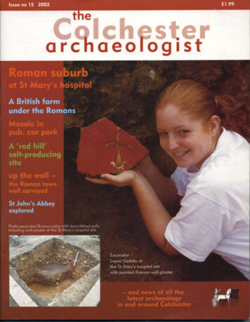
W i t h thanks to all t h e contributors to this issue of t h e m a g a z i n e Pat Brown of Colchester Y o u n g Archaeologists' ClubM i k e Corbishley of English Heritage EducationEssex County Council Heritage ConservationJames FawnA n d r e w PhillipsFront cover: Trust excavator LauraGadsby holding a piece of paintedR o m a n wall-plaster in t h e R o m a n cellarwhere it was excavated.Friendsof the Colchester A r c h a e o l o g i c a l T r u s tdesigned by Gillian Adamsunattributed text by Howard Brookswith additional material by Carl CrossanPrinted by PrintWright Ltd, IpswichIf y o u a r e interested in f o l l o w i n g a r c h a e o l o g i c a ldiscoveries i n Colchester, t h e n w h y n o t c o n s i d e r j o i n i n gt h e Friends o f t h e Colchester A r c h a e o l o g i c a l Trust?M e m b e r s h i p c o n t i n u e s t o rise a n d n o w stands a t a b o u t4 5 0 individuals a n d f a m i l i e s . T h e s u b s c r i p t i o n rates a r em o d e s t , a n d i n c l u d e a n a n n u a l c o p y o f t h e Colchesterarchaeologist m a g a z i n e delivered to y o u as s o o n as it isp u b l i s h e d . Y o u c a n also j o i n t o u r s o f c u r r e n t sites a n do r g a n i s e d trips t o places o f historical a n d a r c h a e o l o g i c a linterest i n t h e r e g i o n . Colchester Archaeological Trust 2 0 0 2ISSN 0 9 5 2 - 0 9 8 8T h e a n n u a l s u b s c r i p t i o n rates:A d u l t s a n d institutions 3.50Family m e m b e r s h i p 4.50C h i l d r e n a n d students 2.50All images copyrightColchester Archaeological Trustunless stated otherwiseFurther d e t a i l s c a n b e o b t a i n e d f r o m M a u r e e n Jones,Friends of C o l c h e s t e r A r c h a e o l o g i c a l T r u s t , 5 A s h w i nA v e n u e , C o p f o r d , Colchester, Essex C 0 6 1BS o rwww.friends-of-cat.ndo.co.ukThe Colchester archaeologist m a g a z i n e is largely f u n d e d by t h eFriends of Colchester A r c h a e o l o g i c a l Trust - see page 3 2 .T h e Trust is grateful to Colchester Borough Council for placing anadvertisement on page 33 a n d for its support of the m a g a z i n e .T h e Colchester A r c h a e o l o g i c a l Trust is a f u l l - t i m e professional unit, providing developers a n d others with a fullrange of a r c h a e o l o g i c a l services, f r o m consultancies a n d siteevaluations to full excavation. We have over 25 years'experience of working in partnership with constructionindustry professionals a n d local g o v e r n m e n t p l a n n i n gd e p a r t m e n t s . T h e Trust is a registered charity a n d a c o m p a n ylimited by g u a r a n t e e .We design a n d publish our o w n reports, books a n dmagazines in-house.Colchester Archaeological Trust12 Lexden R o a d ,Colchester,Essex C 0 3 3 N FPicture on opposite page: view of t h eSt Mary's hospital site f r o m t h e HillyFields; the tower of t h e T o w n Hall isvisible in the b a c k g r o u n d haeologists@colchester-arch-trust.co.ukweb site: www.colchester-arch-trust.co.uk
contentsIn brief.2A British f a r m under t h e Romansfinal excavations at the Abbotstone site near Colchester Zoo4Salt of t h e e a r t h !ancient salt-making at Great Wigborough7New light on Colchester Castleheavy smokers at the castleR o m a n Colchester's western suburbmajor excavations begin at the f o r m e r St Mary's hospitalT h e Victorian workhouseA n d r e w Phillips explains how it became an NHS hospital891016Water supply in R o m a n Colchesternot equalled in the town for 1,200 yearsBritain's first t o w n wallRoman public buildings recycled(with reconstruction by Scout Design)St John's Abbey exploredT h e Y o u n g Archaeologists' Clubfor budding archaeologists in the Colchester area1819202327by Pat Brown' W i s for.the bell-maker's mark by James FawnAerial archaeology of 'Constable country'mapping the past from the airby Essex County Council Heritage Conservation2829T h e left l u g g a g e g a m earchaeology for young peopleby M i k e Corbishley of English Heritage EducationFriends of t h e Colchester A r c h a e o l o g i c a l TrustMosaic f o u n d at t h e Victoria Innpart of a large Roman house north of the River Colnea n d earlier discoveries at the Victoria Inn303233-34
O p e n day at St Botolph's priory andslide show of the St Mary's hospitalsite on a monitor, using a laptop.In brief.Web siteT h e Colchester A r c h a e ological Trust has aweb-site. It features t h elatest news a b o u t sites a n dpublications in Colchester,as well as clickable m a p sw h i c h allow visitors toexplore interactively someColchester archaeologicalsites. Visit us at www.colchester-arch-trust.co.uk.Mr Currey's gardenA few years a g o , Mr RalphCurrey generously permittedpart of his g a r d e n wall to betaken d o w n so t h a t an a r c h a e ological excavation could bec o n t i n u e d into his g a r d e n by afew feet. T h e purpose of t h e digwas to find t h e c r e m a t e dremains of a R o m a n cavalryofficer called Longinus. T h eexcavation was a c o n t i n u a t i o nof t h e o n e w h e n James Fawn oft h e Colchester A r c h a e o l o g i c a lG r o u p had famously f o u n d themissing face f r o m Longinus'tombstone.Offering to a god?C o m p l e t e R o m a n pots characterise cemetery sites - they arerelatively rare inside t h e t o w nwalls, where burial was not generally allowed in R o m a n times.Pottery f r o m t h e t o w n centre isalmost always broken discardedrubbish. However, an almost c o m plete white-slipped pot was f o u n din 2 0 0 1 , on a building site atSt Peter's Vicarage on North Hill.Because it was probably deposited c o m p l e t e , it is likely to be partof a votive deposit c o n t a i n i n gf o o d or drink offered to a g o d .Examples of such 'votive' offeringshave been found occasionally inthe past in Colchester; they includea pot on the Lion Walk site whichwas buried with the remains ofthree puppies.T h e work was f u n d e d by t h e Colchester Borough Council.In t h e event, Longinus' m o r t a lremains were nowhere to bef o u n d , a n d the wall had t o b ereplaced. Tendring Construction Ltd verykindly c a m e to t h e rescue a n d sent masterbricklayer Phil ' S w a m p y ' Baker a l o n g torebuild the wall (see picture).Phil was keen to do t h e work because thewall had been built in t h e rare ' r a t - t r a p 'b o n d , a n d he felt t h a t there was littlec h a n c e of his being able to work on a wall ofthis kind a g a i n . He explained t h a t rat-trapbond was developed in the 1800s for t w oreasons. It was designed to stop rats gettinginto roof spaces, a n d , being semi-hollowwith cross bricks, rat-trap b o n d saved onbricks.Later in t h e s a m e year, after t h e g a r d e n a n dwall had been restored, we were verysaddened to learn of the d e a t h of MrCurrey. He was a f o r m e r English a n d Historyteacher a t t h e G r a m m a r School, a n d a nestablished poet with a national r e p u t a t i o n .The Trust a n d the Colchester A r c h a e ological Group are m u c h indebted to PhilBaker and Tendring Construction for theirhelp with the wall, a n d to the late Mr Curreyfor his forbearance in m a k i n g it all possible.2Friends' donationsM a n y thanks t o t h e Friends o fC A T for their generosity overthis year. T h e Friends f u n d e d :t h e purchase of software for t h egeophysics surveys, they paidfor t h e hire of a g r o u n d - r a d a rm a c h i n e for the t o w n gatessurvey (page 2 2 ) , a n d theypurchased a seat for t h e R o m a nc h u r c h (page 32). T h e Friendsalso contributed m o r e t h a nusual for last year's m a g a z i n eso t h a t some of t h e pages insidecould be in full colour.Volunteer David Sims helps toprocess finds from the excavations. Thanks to all our volunteers for their help over the year.
A cautionary taleBirch airfield was constructed by the United States Air Force in 1 9 4 3 . In M a y2 0 0 1 , w h e n exploratory trenches were d u g a t t h e edge o f t h e airfield, o n e o fthe more unusual finds was a large pit c o n t a i n i n g e q u i p m e n t d u m p e d by theUS 9 t h Air Force before returning h o m e at t h e end of World W a r 2. No GlennMiller g r a m o p h o n e records or jeeps c a m e to light, but instead a stove,electrical items a n d broken plates were d u g o u t of t h e upper levels of t h e pit.T h e plates are British a n d include o n e s t a m p e d ' R A F 1 9 4 1 ' (see picture),w h i c h seems o d d because Birch airfield was never used by t h e Royal AirForce. There is an archaeological lesson to be learnt here: w i t h o u t thew a r t i m e d o c u m e n t a r y record, it w o u l d be easy to assume wrongly f r o m t h epottery evidence a l o n e t h a t Birch airfield had been a RAF base. We c a n onlyhope t h a t the R o m a n military did not exchange e q u i p m e n t in this m a n n e r .T h e work was f u n d e d by H a n s o n Aggregates.Careful where you stand!Footprints sometimes occur on Roman bricks. T h e culprits a r e usuallya n i m a l s t h a t have been allowed tow a n d e r a m o n g t h e unfired bricks(laid o u t d u r i n g t h e m a n u f a c t u r i n gprocess). But a f r a g m e n t recentlyf o u n d on a site in West Lodge Road,Lexden bears t h e i m p r i n t of a h o b nailed boot a n d pointsthe finger, so to speak,a t t h e brick-makerhimself.The workwasf u n d e d byCrowdel IAssociates.T h e Trust's book onthe archaeology ofColchester up tocirca 1 2 0 0 AD hasbeen reprinted. Thereprint was madepossible with thegenerous support ofthe Hervey BenhamCharitable Trust.City of Victory isavailable inbookshops for 12.50.Trenching by the kilometreThe route of t h e new Northern A p p r o a c h e s Road where it passes t h r o u g h Severalls a n dCuckoo Farm had to be checked for a r c h a e o l o g i c a l remains, a n d so t o o did s o m ed e v e l o p m e n t land a l o n g part of the new road in an area to t h e west of the General Hospital.Accordingly the Trust excavated over three kilometres of trenches by m a c h i n e within t h espace of a b o u t t w o m o n t h s . This is t h e t e c h n i q u e normally employed on d e v e l o p m e n t sitesto ensure t h a t significant archaeological remains are not d a m a g e d or destroyed w i t h o u ta d e q u a t e record. In the event, various ditches a n d gullies of Iron A g e a n d R o m a n d a t e weref o u n d on the site west of t h e hospital, whereas t h e route of the road t h r o u g h Severalls a n dCuckoo Farm was p r o n o u n c e d clear. M o r e a r c h a e o l o g i c a l investigations seem likely in bothplaces.The works were commissioned by Cofton Land and Property (the land west of the General Hospital)and by AERC on behalf of the Secretary of State for Health (Cuckoo Farm and Severalls).Pictures - right: a trench with the hospital in t h e b a c k g r o u n d ; below: view of part of t h e site,looking towards Colchester t o w n centre.3
A British f a r munder the Romans2 0 0 1 saw t h e f i n a l season o f e x c a v a t i o n a t t h e A b b o t s t o n ec r o p m a r k site, w h i c h is q u i t e close to C o l c h e s t e r Z o o .W h a t w a s t h e n a t u r e o f t h e site?W a s it a R o m a n f a r m , a n d how is it c o n n e c t e d w i t hCamulodunum?Where was Camulodunum?' N o m a n is an island', a n d neither isany a r c h a e o l o g i c a l site. T h e A b b o t s t o n esite is part of a wider archaeologicallandscape of international i m p o r t a n c e .O t h e r archaeological sites in the vicinityare: t h e Stanway burial site ( 1 4 0 0 meast); Grymes Dyke ( 1 6 0 0 m east); a n dt h e late Iron A g e a n d R o m a n site atGosbecks, with its classical R o m a nt e m p l e a n d t h e a t r e (east of GrymesDyke). C a m u l o d u n u m had t w o centresof activity: Gosbecks, w h i c h was probably t h e site of king Cunobelin's f a r m stead, a n d Sheepen (near the presentday Colchester Institute), w h i c h wasp r e d o m i n a n t l y concerned with t r a d e a n dmanufacturing.C a m u l o d u n u m was d e f e n d e d by asystem of earthworks or dykes (see plan).T h e burial site at Stanway was actuallyoutside t h e defences o f C a m u l o d u n u m ,t h o u g h it was unquestionably linked to itsocially (and chronologically). Like Stanway, t h e A b b o t s t o n e site is also outsidet h e d e f e n d e d parts of C a m u l o d u n u m .T h e question t h e n is, to w h a t extent wast h e A b b o t s t o n e site actually part ofC a m u l o d u n u m ? A n o t h e r question is thed y n a m i c between native a n d R o m a nsettlement. Stanway was a native burialsite, a n d Gosbecks was a native sitew h i c h b e c a m e R o m a n i s e d . H o w doesthe A b b o t s t o n e site fit into this picture?Was it a native f a r m s t e a d w h i c h coexisted with Gosbecks a n d t h e n o u t lived it, or was it t a k e n over by R o m a nsettlers?4
Previous excavationsLike Stanway a n d Gosbecks, A b b o t s t o n ehas been k n o w n for s o m e t i m e as ac r o p m a r k site. Fieldwalking surveys (surface collections of objects) by t h e Trustin 1997 a n d 1 9 9 8 scanned areasbeyond the c r o p m a r k s , to check for previously u n k n o w n archaeological remains.We identified t h i n spreads of prehistoricflints a n d R o m a n brick a n d tile, with at h i n c o n c e n t r a t i o n of R o m a n brick a n dtile directly north of t h e c r o p m a r k site.Surprisingly there was no surface material over the c r o p m a r k itself. T h e Trustundertook a geophysical survey overthe cropmarks in 1998 w h i c h failed toestablish the location of a r c h a e o l o g i c a lfeatures below the ploughsoil, possiblybecause t h e g r o u n d was t o o wet. T h ec r o p m a r k site was extensively trialtrenched by t h e Trust in early 1 9 9 9 . Thisat last pinpointed t h e surviving subsoilfeatures, thereby identifying t h e areaswhere full-scale archaeological excavation should be carried out.The Trust's excavation in 1 9 9 9 showedt h a t t h e earliest activity here is represented by a few worked flints of probablelate Neolithic or Bronze A g e date. T h eearliest i m p o r t a n t f e a t u r e was a ditchdefining a roughly circular enclosure - apotential prehistoric house site. Therewas no sign of t h e post-holes w h i c hm i g h t show the position of a roundhouse, but the excavation of t h e ditchproduced M i d d l e Iron A g e pottery w h i c hconfirmed its prehistoric d a t e (see m a g azine no 1 3).The Trust excavation t e a m returned toexcavate the rest of the site late in 2 0 0 0 ,but the very wet ground conditions prevented m u c h digging, and the season hadto be c a n c e l l e d .2 0 0 1 excavationThis year's task was to c o m p l e t e t h eexcavation of t h e r e m a i n d e r of t h e largeR o m a n enclosure. This was no m e a ntask - standing water had to be p u m p e do u t of all the features, a n d the site had tobe scraped clean by m a c h i n e to removet h e silts w h i c h had washed o n t o t h e siteover t h e winter. T h e m a i n results havebeen the discovery of m a n y m o r e ditchlines t h a n were visible on t h e airp h o t o g r a p h s or were expected after theprevious season of d i g g i n g . A h u m a nskull was f o u n d , with s o m e brokenpottery, in a Late Iron A g e d i t c h near t h eM i d d l e Iron A g e enclosure (see picture).T h e lower jaw was missing, suggestingt h a t t h e skull had been placed herew h e n already d e c o m p o s e d . T h e skullm a y be t h e remains of a burial orperhaps a ritual deposit.FarmingIt w o u l d appear t h a t there was a g a p inactivity on the site until the late Iron A g e ,w h e n ditches were cut to define a largeenclosure. In f a c t the majority of thefeatures on the site were ditches definingthree large enclosures - first the IronA g e o n e m e n t i o n e d above, a n d thent w o separate R o m a n enclosures (northa n d south). T h e joint life-time of theenclosures spanned the later Iron Age tot h e m i d 3rd century A D . The north (andlarger) R o m a n enclosure had smallerditches or gullies splitting it into smallerpaddocks or fields, a n d other parallelditches m a r k i n g o u t road lines whichwere originally m e t a l l e d . There wereseveral c r e m a t i o n burials, o n e of t h e man interesting post-burial (where ac r e m a t i o n had been placed in a deeppost-hole w h i c h presumably held a largepost to m a r k t h e spot). W h a t was mostintriguing a b o u t t h e first season's workwas t h e c o m p l e t e absence of buildings.T h e r e m a i n i n g part of the ditch a r o u n dt h e house site was excavated, a n d(gratifyingly) a ring of post-holes wasdiscovered. These define t h e site of aprehistoric structure (presumably a house)on this spot. T h e internal d i a m e t e r of t h epost-hole ring was a p p r o x i m a t e l y 1 0 m ,so w i t h a c o n v e n t i o n a l t h a t c h e d roofo v e r - h a n g i n g this post-hole ring, t h estructure m i g h t have been closer toa p p r o x i m a t e l y 1 4 m external d i a m e t e r by no m e a n s a small building (seepictures).A b o v e : Ben Holloway uncoveringthe h u m a n skull.Left: plan of C a m u l o d u n u m .Opposite page T o p : sketch of a M i d d l e Iron A g eround-house.B o t t o m : the t e a m m a r k i n g thepositions of the eleven post-holesof t h e M i d d l e Iron A g e roundhouse.5
There was a short stretch of possiblebeam-slot associated with the postburial, but no other structural features ata l l . T h e southern (and smaller) R o m a nenclosure was equally i n t r i g u i n g . It hadopposed entrances, t h e northern o n ehaving a pair of gate-posts set back f r o mt h e d i t c h line, w h i c h w o u l d imply theexistence of an internal bank with t h eg a t e between t h e ends of t h e bank.Still describing t h e site as a series ofenclosures, it is now possible to suggesta sequence of d e v e l o p m e n t . T h e earliestenclosure seems to have developed o u tof t h e circular Iron A g e house site, a n dto have been a d d e d to progressively,until the enclosure was regularised bybeing recut in t h e R o m a n period as o u rnorth enclosure. T h e south enclosurewas a d d e d later o n , also in t h e R o m a nperiod. Some of t h e ditch lines areboundaries f r o m a n a d j a c e n t fieldsystem w h i c h join up with the enclosureditches, a n d r e m i n d us t h a t the site waspart of a wider f a r m e d landscape.Above: lines were paint-sprayed on t h eg r o u n d t o outline t h e archaeologicalfeatures as they were uncovered bym a c h i n e . Parts of t h e features were t h e nh a n d - d u g so t h a t we could d a t e t h e m ,explore their physical characteristics,a n d recover environmental m a t e r i a l .Given t h a t t h e site was o c c u p i e d f r o mthe late Iron A g e to the mid 3rd century,the question of t h e location of the livingareas t h e n arises. T h e Iron A g e r o u n d house is an obvious focus for o c c u p a t i o n a t t h a t t i m e , but w h a t a b o u t theR o m a n period? It seems clear f r o m t h equantitiesofpotterydebris a n d occasionalcremation burials, t h echeese presses a n d t h elarge n u m b e r o f f r a g ments of querns (usedfor g r i n d i n g cereals intoflour), t h a t there was agreat deal of activityhere in R o m a n times,mostly agricultural activity. But where were t h ebuildings? W i t h smallAbove: Sam Deeprose hard at work.Right: a n excavation t h r o u g h t w o intercuttingditches, with Philip Lomas in the b a c k g r o u n d .6quantities of R o m a n w i n d o w glass,roof-tile f r a g m e n t s a n d even flue-tiles(normally associated with hypocaustsystems) c o m i n g f r o m this site, there isan obvious m i s - m a t c h between the findsevidence a n d the site evidence. Perhapst h e R o m a n structures were surface-builtw i t h o u t rubble f o u n d a t i o n s , a n d haveleft no trace. Perhaps these finds occurhere as d u m p e d rubbish, having beentransported f r o m somewhere else.A b b o t s t o n e is a" site where we c a n n o tc o m e up with all the answers. However,t h e enclosures are part of a late Iron A g ea n d mainly R o m a n rural site concernedprincipally with f a r m i n g . If R o m a n buildings were erected here, they have notsurvived.W h a t a b o u t t h e inhabitants? It is difficultto see a radical c h a n g e between the IronA g e enclosure a n d t h e R o m a n enclosures, so there is no basis for a r g u i n g forR o m a n settlers c o m i n g in to live on anIron A g e site (there is a lack of highstatus finds like coins a n d evidence ofbuildings). In fact, t h e lack of rich findsa n d the a l m o s t total absence of metalfinds m i g h t indicate t h a t it c o n t i n u e das a native (British) site w h i c h neverb e c a m e a R o m a n villa, a n d was neverlived in by well-to-do Romano-Britons.To take a different a n g l e , perhaps thelack of buildings is a reflection of the factt h a t the people w h o f a r m e d here did notnecessarily live here. Perhaps t h e sitewas o w n e d by absentee landlords, w h oused a t e a m of locals to w o r k t h e landhere, a n d perhaps even those workerslived off site.The excavations at Abbotstone werefunded by T a r m a c Quarry ProductsLtd.
Salt of the earth!Salt is o n e of life's necessities. Before thediscovery of the inland sources of salt inCheshire a n d Warwickshire w h i c h stillsupply us today, salt was producedmainly by distillation of sea water atcoastal sites. There is evidence for prehistoric salt-production at M u c k i n g a n dFenn Creek ( W o o d h a m Ferrers) in Essex,but the best evidence is f r o m t h e lateIron A g e a n d R o m a n period w h e n over3 0 0 salt-making sites are k n o w n f r o mEssex alone. These sites are called 'redhills', because they survive to this day aslow red m o u n d s at approximately highwater mark.These curious sites have attracteda n t i q u a r i a n a n d archaeological interestfor some t i m e . In days g o n e by, theywere t h o u g h t to be Saxon or Danishpotteries, R o m a n brickyards, or c a m p sites used by q u e e n Boudica or Alfredthe Great w h e n he was hiding f r o m theDanes. Organised research dates backto 1 8 7 9 , but t o o k on fresh impetus in1906 with t h e f o r m a t i o n of t h e Red HillsExploration C o m m i t t e e w h i c h d u g a tvarious red hill sites in L a n g e n h o e a n dHullbridge. In recent years, Kay deBrisay was t h e m a i n motivating force inred hill research, d i g g i n g sites in M a l d o nand Peldon.W h e n the Essex Wildlife Trust applied forconsent to create a wildlife sanctuaryby breaking t h e sea wall at GreatW i g b o r o u g h t o allow m a n a g e d retreatof the coastline by t h e sea, this affectedseveral red hill sites. T h e Trust wasGreat Wigboroughcontracted by the Wildlife Trust to fieldwalk the site a n d then test-trench anyconcentrations of material. The fieldwalk revealed several surface c o n c e n t rations (see chart) of R o m a n pottery a n d' b r i q u e t a g e ' , t h e debris f r o m salt m a n u facture. W h e r e briquetage survives inidentifiable f r a g m e n t s , it appears to beof large vessels in w h i c h salt was driedo u t or various pieces of clay rods, propsa n d bars w h i c h m i g h t have supportedthe clay vessels over the fire. O n e suchf r a g m e n t f r o m W i g b o r o u g h was t h e 'firebar' illustrated above.Several test-trenches were t h e n cut overt h e area of surface finds (see picture).T h e removal of t h e ploughsoil revealedthe tell-tale red-coloured earth of t w oseparate red hills, a n d t h e o u t l i n e ofw h a t m a y have been clay-lined 'settlingt a n k s ' o n c e used in t h e salt-makingprocess. A geophysical survey by A l i n ea n d David Black for t h e Trust locateddistinct a r c h a e o l o g i c a l ' h o t spots' overt h e area of o n e of t h e red hills. Fired claystructures like hearths are particularlysusceptible to detection by m a g n e t ometry, a n d it m a y be t h a t t h e g e o physical survey has located a n u m b e r ofsalt-drying hearths on this particular redhill. W h e n the sea wall is b r e a c h e d , thesite will be f l o o d e d , as it was f r o mR o m a n times until t h e construction ofthe sea w a l l .Key R o m a n potteryR o m a n tilebriquetageT h e fieldwalkingwas d o n e withthe help of theStoke-byNayland WEAFieldwalkingGroup.T h e work at Abbotts Hall Farm wasfunded by the Essex Wildlife Trust.T o p left: briquetage f r a g m e n t a n d reconstruction.T o p right: fieldwalking chart.A b o v e : t r e n c h i n g in field.Left: the water feature - elsewhere at Abbotts H a l l ,excavations for a freshwater lake uncovered wooden postsstretching across an infilled c h a n n e l w h i c h o n c e d r a i n e dtowards t h e estuary. The posts are oak, with sharpened points.Almost a h u n d r e d were finally exposed, f o r m i n g t w o parallellines about three metres apart. M o s t were left in place a n dcovered with a protective layer of clay to help preserve t h e mw h e n t h e lake is filled. T h e few finds suggest t h a t t h e structure- perhaps a jetty or small bridge across the creek - m i g h t beR o m a n , but as this is not certain, we are eagerly a w a i t i n g t h eresults of tree-ring analysis w h i c h will be carried o u t by t h eD e n d r o c h r o n o l o g y D e p a r t m e n t at Sheffield University.7
New light onColchesterCastleT h e installation of newfloodlights for the Castlem e a n t t h a t over 2 0 0 metres oftrenches had to be dug for theunderground cabling. Being animportant archaeological site,the trenches needed to be dugby archaeologists and theloose soil checked with ametal detector.A surprising discovery was t h e largea m o u n t of rubble a n d broken tile inm a n y of t h e trenches. T h e material mustlargely relate to t h e late 17th centuryw h e n John Wheeley was knocking d o w nm u c h of t h e Castle. It conjures up apicture of a ruined a n d half-demolishedCastle surrounded by great heaps ofrubble.A n o t h e r striking feature of t h e w o r k wasthe large n u m b e r of clay-pipe f r a g m e n t sf o u n d in the trenches. T h e shaft for t h elift d u g inside t h e Castle in 1 9 9 2 was justthe s a m e , a n d produced large n u m b e r sof bits of broken clay t o b a c c o pipes.Clearly there must have been a lotof smoking in a n d a r o u n d the castlei n t h e past. T h e m e n working o n thed e m o l i t i o n of t h e castle must havesmoked incessantly as they broke up thewalls a n d cleaned t h e stone a n d brick forreuse by c h i p p i n g off the old mortar.However, the most useful o u t c o m e ofthe excavation was t h e realisation t h a tthe f a c i n g stones on t h e batter at t h ebase of t h e keep wall were removed inthe late 17th century as part of t h ed e m o l i t i o n works for t h e castle. We c a ntell this because we f o u n d t h a t they arestill intact below t h e ground-level ofT o p : t h e castleceremony.atthefloodlightingLeft: view of t w o parts of the site, f r o mt h e t o p o f t h e castle a n d o n t h e g r o u n d .Right: excavators w o r k i n g by t h e castlewall.8circa 1 7 0 0 . This s a m e level correspondst o t h e t o p o f t h e f o u n d a t i o n s o f thechapel a n d other buildings on the southside of t h e castle, showing t h a t thesemust have been d e m o l i s h e d to g r o u n d level at t h e s a m e t i m e . N o n e of this canbe c l a i m e d to be especially interesting,but it all helps us to understand how thecastle c a m e to be in the state t h a t it istoday, a n d thus w h a t it m i g h t havelooked like originally.PCT h e excavation was commissioned byColchester Museums.
RomanColchester'swestern suburbT h e planned redevelopment of theSt Mary's hospital site presents achance to explore part of a largeRoman suburb outside the BalkerneG a t e . T h e nature of the archaeologicalremains can be predicted to a degree,because of the major excavation of the1 9 7 0 s on the Balkerne Lane siteimmediately to the south. And there isan old, undocumented plan showingw h a t appears to be the remains of aRoman temple on the St Mary'shospital site itself.Like t h e m o d e r n t o w n , the R o m a n t o w nof Colchester had suburbs outside t h et o w n wall. A large part of the westernsuburbs were excavated by t h e Trust inthe 1970s before t h e construction ofSt Mary's multi-storey car park onBalkerne Hill. As a result, it was possibleto trace the d e v e l o p m e n t of the areaimmediately south of t h e site of t h eformer St Mary's hospital f r o m t h e mid1st century o n w a r d s .The g r o w t h of t h e suburb reflects t h eg r o w t h of the R o m a n fortress a n d t o w nlying to the west. W i t h i n a few years ofthe R o m a n conquest o f A D 4 3 , a g r o u pof flimsy buildings, perhaps workshops,had been erected outside t h e westgate of the R o m a n fort. By the t i m e ofthe Boudican revolt o f A D 6 0 / 1 , m o r esturdy-looking buildings had t a k e n theirplace, lining each side of the L o n d o nroad w h i c h now passed t h r o u g h t h e freestanding t r i u m p h a l arch (on the site ofBalkerne Gate). These were presumablyshops a n d workshops providing serviceindustries to the t o w n . After the revolt, inthe period A D 8 0 - 1 0 0 , the inhabitantsand shop-keepers in the western suburbmust have felt they d i d n ' t fit in in t h equite the same way as before, becausethe R o m a n t o w n wall had now beenerected - a physical barrier between t h esuburbs a n d t h e t o w n , w h i c h incorporated the previous free-standing archwayand converted it into t h e west g a t e of thet o w n . A Romano-Celtic t e m p l e was alsobuilt
With thanks to all the contributors to this issue of the magazine - Pat Brown of Colchester Young Archaeologists' Club . Britain's first town wall Roman public buildings recycled 19 (with reconstruction by Scout Design) 20 . which is quite close to Colchester Zoo. What was the nature of t