Transcription
Regional Guidance forHydrologic and Hydraulic StudiesIn support of the Model Ordinance forFloodplain Management and the Endangered Species Act2010Region 10
Regional Guidance forHydrologic and Hydraulic Studiesin support of theModel Ordinance for Floodplain Managementunder the National Flood Insurance Programand theEndangered Species ActProduced by FEMA - Region 10January 2010FEMARegion 10For additional information or copies of this guidance:Federal Emergency Management AgencyAttn: Mitigation DivisionFederal Regional Center, Region 10130 228th St. SWBothell, WA 98021-9796(425) 487-4600www.fema.gov/regionx/nfipesa.shtm
NFIP-ESA H&H Guidance ii January 2010
ContentsIntroduction . 1Background . 1Hydrologic and Hydraulic Study Guidance . 1Future Conditions Floodplain Studies . 3Background . 3Types of Future Conditions . 4When to Analyze Future Conditions . 6Future Conditions Hydrologic Analysis . 7Future Conditions Hydraulic Analysis . 7Future Conditions Summary . 8CRS Credit for Future Conditions Mapping . 8Hydraulic Models. 10Current Models . 10Regional Guidance . 11CRS Credit for Hydraulic Modeling . 12Channel Migration Zones . 13Background . 13Biological Opinion Requirements . 13Regional Guidance . 14CRS Credit for Mapping Channel Migration Zones . 16Appendix A. References . A 1Appendix B. Flow Control-Exempt Surface Waters . B 1NFIP-ESA H&H Guidance iii January 2010
AcknowledgementsThis guidance document was developed by Region X of the Federal EmergencyManagement Agency, as part of its continuing effort to improve floodplainmanagement practices and assist communities in meeting the requirements of theEndangered Species Act.It was prepared with the advice and assistance of a special advisory committeethat included representatives from: City of Auburn City of Carnation City of Everett Island County Jefferson County King County City of Lacey Lummi Nation City of Monroe Pierce County San Juan County Snohomish County City of Tukwila Washington State Department of Ecology Whatcom County The National Marine fisheries ServiceWhile some comments were not incorporated, the reviews of each agency in acommon endeavor to make this a useful guidance tool are appreciated.This document was drafted by French & Associates, Ltd., Steilacoom, ESAAdolfson, Seattle, and PBS&J, Seattle, through an arrangement with the InsuranceServices Office and the Community Rating System.NFIP-ESA H&H Guidance iv January 2010
IntroductionBackgroundThis Regional Guidance is written for communities in the Puget Sound Basin to assist them inmeeting the requirements and criteria of the Endangered Species Act (ESA) as clarified in theBiological Opinion issued by the National Marine Fisheries Service on September 22, 2008. Theprimary audience for this guidance is engineers and other technical staff involved with mappingflood hazards.This guidance was prepared with input from local officials, engineers, natural resourcesscientists, and planners. It will assist local officials and developers determine the mostappropriate ways to prepare flood hazard data that meet the requirements of the National FloodInsurance Program (NFIP) and the ESA.This document is designed to support the NFIP-ESA Model Ordinance, which was also preparedby FEMA Region X.Hydrologic and Hydraulic Study GuidanceFEMA develops flood data and publishes flood hazard maps to support the NFIP. The data aresummarized in Flood Insurance Studies and the maps are known as Flood Insurance Rate Maps(FIRMs). These products define the Special Flood Hazard Area (SFHA), which is the areapredicted to be inundated by a flood having a 1-percent probability of being equaled or exceededin any given year (also referred to as the 100-year flood or base flood). The SFHA designates theminimum area that a community in the NFIP must regulate. The “Regulatory Floodplain,” asdefined in the model ordinance, is the SFHA plus those areas of riparian habitat and channelmigration areas that extend beyond the SFHA.There are normally three major phases to a FEMA flood study of a stream or river:1. Assess the flows (usually involving a hydrologic study)2. Determine flood elevations and the floodway (via a hydraulic analysis)3. Map the floodplain (SFHA) and floodwayFlood studies conducted for the NFIP are prepared by mapping partners, including state andregional agencies and local governments. FEMA’s mapping criteria are spelled out in Guidelinesand Specifications for Flood Hazard Mapping Partners (called Guidelines and Specifications inthis document), which are available at http://www.fema.gov/plan/prevent/fhm/gs main.shtm.Guidelines and Specifications includes technical appendices which are updated as necessary. Theprimary technical appendix that relates to the issues discussed in this Regional Guidance isAppendix C: Guidance for Riverine Flooding Analyses and Mapping (FEMA, 2002).NFIP-ESA H&H Guidance 1 January 2010
This Regional Guidance is intended to supplement existing guidance for communities who wishto prepare studies in consideration of special ESA provisions for Washington State as explainedin the Biological Opinion. The Biological Opinion identified three specific areas where studytechniques need to be adjusted to provide better hazard data: Use foreseeable future land use changes to establish future base flood elevations, Use unsteady one-dimensional or two-dimensional hydraulic models to analyze complexriverine systems when applicable, and Include the channel migration area as part of the regulatory floodplain.These three subjects are covered in the following three sections. Communities are not required touse this guidance and it does not define the only approaches to follow. However, communitiesthat do follow this guidance will meet the ESA requirements as spelled out in the BiologicalOpinion, and have a more effective program to reduce the dangers and damage caused by floodsand migrating stream channels.Each section also includes a discussion of how each of the three major elements ofthis guidance relate to potential Community Rating System (CRS) credits. Moreinformation on the CRS can be found in Appendix D of the NFIP-ESA ModelOrdinance and at A H&H Guidance 2 January 2010
Future Conditions Floodplain StudiesBackgroundFlood Insurance Rate Maps serve several purposes: They guide local floodplain management programs, They establish insurance premium rates, and They are used to determine when a flood insurance policy is required under themandatory purchase requirement.After a review of the legal issues, FEMA’s counsel concluded that FIRMs used for the last twopurposes need to be based on the current conditions on the ground. In 2001, FEMA issued areport, Modernizing FEMA’s Flood Hazard Mapping Program: Recommendations for UsingFuture-Conditions Hydrology for the National Flood Insurance Program. That report noted:As discussed in Flood Insurance Study Guidelines and Specifications for Study Contractors” (FEMA37, January 1995), flood hazard determinations should be based on conditions that are planned toexist in the community within 12 months following completion of the draft Flood Insurance Study(FIS) report. Examples of future conditions to be considered in the context of FEMA 37 are publicworks projects in progress, including channel modifications, hydraulic control structures, stormdrainage systems, and other flood protection projects. These are changes that will be completed in thenear future for which completion can be predicted with a reasonable degree of certainty and theircompletion can be confirmed prior to the NFIP map becoming effective .The current procedure for flood insurance rating is that structures shown within the existingconditions 1-percent-annual-chance (100-year) floodplain are subject to a mandatory purchaserequirement. Due to statutory constraints at this time, FEMA can not use future-conditions data forflood insurance purposes. Therefore, there will be no change in the use of existing conditions data forestablishing flood insurance rates. Through community participation in the CRS, reduced floodinsurance rates are available for those communities that enforce more stringent regulatory standardsthan required by the NFIP. [pages 2 – 3, 5]While the SFHA on a FIRM cannot be based on future conditions, local floodplain managementprograms are welcome to use future conditions maps, as long as the regulatory floodplain is atleast as large as the currently effective SFHA. In fact, Recommendations for Using FutureConditions Hydrology concludes with a recommendation that FIRMs display the futureconditions floodplain for informational purposes. This has been done where requested by thecommunity.The 2008 Biological Opinion stated:The FEMA will also revise map modeling methods to consider future conditions and the cumulativeeffects from future land-use change, to the degree that such information is available (e.g. zoning,urban growth plans, USGS Climate study information). Future conditions considered should includechanges in the watershed, its floodplain, and its hydrology; climate change, and other conditions thataffect future flood risk. The FEMA shall ensure that jurisdictions use anticipated future land usechanges when conducting hydrologic and hydraulic calculations to determine flood elevations. [page158]NFIP-ESA H&H Guidance 3 January 2010
This section shows how the Biological Opinion requirements can be met within FEMA’s currentmapping guidance.Types of Future ConditionsThe term “future conditions” has a number of possible meanings in the context of mapping floodhazards. From a flood study perspective, there are two general types of changes that can beexpected to occur in the future: Changes in the amount of rain and snow that feed floods (climate change), and Changes in the watersheds that absorb the rain and snowmelt (land-use changes).Changes in precipitation: Changes in precipitation due to climate change are possible. Climatevaries at many timescales, from daily cycles to the glacial-interglacial patterns that occur overmany thousands of years. Changing climate patterns can be difficult to discern because ofsignificant year to year variation and the short observational record.Flood studies are necessarily dependent on pastprecipitation and flow records, which do not provideinformation on flows generated under different climaticconditions. Therefore, existing information is not clear as tohow to alter peak flow predictions to account for a changingclimate (see for example Brekke et al., 2009, Elsner et al.,2009, Rosenberg et al., 2009). Further, the magnitude ofchanges in peak flows due to changing climatic conditionsis expected to be much smaller than changes resulting fromalterations to land use, described below. Therefore, nospecific consideration of changes in peak flow due toclimate change is included in this guidance.FEMA is currently developing a report that will assess howa changing climate will affect the NFIP. The report willinclude estimates of how climate change could impactinland floodplains and coastlands. The report’s findings willbe incorporated into future versions of this guidance.These graphics show the relativeincrease in runoff from a watershedas it is urbanized and the amount ofimpervious surfaces increase.Changes in the watershed: Changes in land use and landcover (e.g., conversion of forest or agricultural land to urban NAI Toolkit, ASFPM, 2003land uses) can have significant impacts on the volume ofsurface water runoff resulting from a given precipitationevent. Changes in land cover typically increase peak flowsby greater than 50 percent in small Puget Sound watersheds, and change the timing of peak flows(see the graphic, Booth et al., 2002, Grant et al., 2008).NFIP-ESA H&H Guidance 4 January 2010
Forest harvest patterns in managed forest land can also influence runoff patterns. Harvestpatterns include re-growth, so it is assumed that future change from these processes is limited,since the bulk of these impacts are already accounted for in past flow measurements.Land-use and land-cover changes in the watershed are anticipated to have the most significantimpacts on peak flows. Therefore, the technical aspects of this guidance are focused onanticipating and planning for flows generated from a more developed landscape.Other physical changes in the floodplain include infrastructure changes, such as bridgereplacement, or land use conversion. If such changes are happening or scheduled within 12months of a flood insurance study being undertaken, FEMA already requires their inclusion in anew flood study.Development in the floodplain also has the potential to result in cumulative affects on floodstorage. For example, if the fringe is filled, the base flood elevation could rise by up to one foot.To comply with the Biological Opinion, communities will need to prevent filling of thefloodplain or include mitigation measures such as compensatory storage so that man-madechanges in the floodplain do not affect future flows. In addition low impact developmenttechniques are required for any development allowed within the floodplain. Therefore,development within the floodplain should not have an impact on downstream flood peaks.On the other hand, there could be natural changes in the floodplain that are not necessarilyaddressed in Guidelines and Specifications. Local critical area regulations encourage preservingthe natural and beneficial functions of the floodplain. As riparian plant communities develop,they may provide greater roughness along the channel banks and overbank areas, increasingflood elevations in those areas.Restoration projects, including levee setback projects, have the potential to change floodingpatterns. If an analysis finds that they do affect base flood elevations or the floodway or SFHAboundaries, a CLOMR from FEMA is required. As more projects are completed, they may havea cumulative impact on flood elevations. However, due to their expense, the few restorationprojects that have been completed cover relatively short reaches. The distribution and effects ofsuch future projects are difficult to predict. This Regional Guidance does not provide amechanism to capture this type of future condition.Conclusion: Development in the watershed has a predictable and measurable impact on theflow regime. This guidance recommends that communities evaluate changes to the base floodfrom expected future watershed development based on the development patterns laid out in theirlocal long range land use plans. At the request of the community, FEMA will reflect the resultsof the community-initiated future conditions study on FIRMs when they are revised. Theflooding extent determined by future conditions analysis and mapping can be depicted as ashaded X Zone on the FIRM, instead of the 500-year floodplain.NFIP-ESA H&H Guidance 5 January 2010
When to Analyze Future ConditionsThere are two situations where it is not necessary to analyze and map future conditions:1. Larger rivers: In general terms, the larger the river system, the less potential impact therewill be from changing land cover (see for example Grant et al., 2008, Herrera, 2004).These larger systems where future conditions analysis is not required are the “flowcontrol-exempt” water bodies listed in the Washington State Department of Ecology’sStormwater Management Manual for Western Washington. The list of these waters is inAppendix I-E of the Ecology manual and Appendix B of this Regional Guidance. The listshould be updated in future versions of the Ecology manual.2. No change expected: Future conditions do not need to be investigated in areas where thecontributing basin has already been developed and these conditions are reflected inexisting floodplain mapping. For instance, if the contributing watershed is in, and isexpected to remain in agriculture or managed forest, these basins do not need to beanalyzed for future conditions.It is most important to capture future conditions for smaller streams that are located in or nearareas that are likely to urbanize, such as in or near a city or its urban growth area. For smallerwatersheds that are currently undeveloped or only partially developed, it is important toinvestigate potential changes in peak flows when more than four percent of the overall watershedwill become effective impervious surface (Booth et al., 2002). As a general rule, futureconditions hydrology should be determined for all cases where over ten percent of a stream’scontributing basin is converted from existing forest lands or has an increase in impervioussurface.These criteria are summarized in Table 1.Analyze futureconditionshydrology?SituationStudy is for a large, flow control-exempt, water bodyNoThe watershed is developed up to the levels shown in the landuse or comprehensive planNoThe watershed is managed forest or agriculture with no potentialfor conversionNo 4% of the watershed will become effective impervious surface,or a 10 % increase is likely if existing condition is 4%YesAll other situationsYesTable 1. When to analyze for future conditionsNFIP-ESA H&H Guidance 6 January 2010
Future Conditions Hydrologic AnalysisTo develop a reasonable estimate of the future conditions 1 percent annual chance flow, it isnecessary to rely on rainfall runoff simulations with altered land use conditions. Gauge analysishas the benefit of using measured data, but the data only reflect past land use, not the future.All of the currently accepted hydrology models for peak flow determination (available athttp://www.fema.gov/plan/prevent/fhm/en hydro.shtm) can be used to estimate future conditionsby changing land cover/use parameters. Some models, such as HSPF and SWMM, will be moreamenable to this type of analysis than others. All runoff models should be calibrated to past floodevents before they are used for base flood determination.Future land use conditions can be developed using comprehensive plans developed bycommunities to comply with the Washington Growth Management Act. These plans specify thetype of land uses and, sometimes, percentage of lot coverage allowed during a foreseeableplanning horizon, such as 20 years.It is recommended that a conservative assumption be used that all of the areas in the watershedwill be developed as planned. This information can be used in the hydrologic model’s land useto-land cover relationships to describe a build-out condition within the watershed.Stormwater management regulations usually require stormwater management facilities that willminimize the impact of development on runoff. The 2005 Ecology manual requires that postdevelopment flow quantities be managed using flow frequencies ranging from 50 percent of the2-year recurrence interval flow to the 50-year recurrence interval flow.The influence of stormwater management facilities on the 1 percent annual chance flood isconsidered to be negligible for the following reasons: They are required to have overflows sufficient to pass the post-development 100-yearflow, They can fail due to extreme flood conditions or deficiencies in design, installation, ormaintenance, Basic retention and detention regulations don’t address timing, so there’s no assurancethat future flooding will not be increased by the facilities, and The basic analytical technique is to ignore all private facilities because of long-termmaintenance issues.Future Conditions Hydraulic AnalysisNo changes to the existing hydraulic analyses techniques are necessary to develop futureconditions floodplain mapping based on land use changes as described above. The same modelsand approach used for existing conditions can continue to be used with different flows developedin the hydrologic analysis, with the exception of anticipating development of vegetation.NFIP-ESA H&H Guidance 7 January 2010
Future conditions discharges are input into the hydraulic model to determine the futureconditions flood hazards. Certain hydraulic parameters may also need to be adjusted based onexpected land-use and land-cover changes, as determined by the community.Vegetation: It is a good floodplain management practice to consider the continuingestablishment of riparian vegetation along channel banks and in the floodplain. Thisdevelopment could have significant influence on the study’s roughness coefficient. For example,using values from Chow, 1959, a central roughness coefficient (Manning’s n) for cultivated landwith no crops is 0.030, and a central value for medium to dense brush in winter is 0.070 (inSturm, 2001). The influence of the roughness coefficient on velocity calculations is linear, sodoubling this value will certainly influence the hydraulic calculations, the resulting base floodelevation, and the extent of flooding.Future conditions hydraulic modeling should consider the potential for riparian and floodplainvegetation to establish and continue to develop. Therefore, future conditions can assume a fullriparian forest community (e.g., 50 years old). Agricultural areas can be considered to remain inproduction and do not require adjustments.Not all areas will be allowed to develop to full riparian forest. If a community has an operationsand maintenance plan (or similar) that includes vegetation maintenance (e.g., to comply withPL84-99), then future vegetation development needs to be as prescribed in the plan.Future Conditions SummaryCommunities should analyze the future conditions flood hazards by using the rainfall runoffmodels and hydraulic models described in Guidelines and Specifications. Future conditions aregenerally impacted by changes to the land cover conditions. These estimates should be predictedby local land use or comprehensive plans. In summary; The use of standard rainfall runoff models with changed land cover conditions tosimulate future watershed development should be encouraged to predict future peakflows and base flood elevations. These estimates should assume full build out aspredicted by local land use plans. Modelers should also consider increasing roughness coefficients within the hydraulicanalysis to simulate the continued growth of vegetation within the study area.CRS Credit for Future Conditions MappingThe Community Rating System (CRS) is summarized in the separate publication,CRS Credit for Habitat Protection and explained in more detail in the CRS Coordinator’sManual. Credit toward reducing flood insurance premiums is provided in communities thatimplement floodplain management measures that are above and beyond the minimum requirements of the National Flood Insurance Program.NFIP-ESA H&H Guidance 8 January 2010
As discussed above, floodplain management regulations using a floodplain map based on futureconditions is above and beyond the guidance in FEMA’s Guidelines and Specifications for FloodHazard Mapping Partners. This can be credited by the CRS, provided: The hydrologic and hydraulic study techniques used are recognized in Guidelines andSpecifications. A technique that is not discussed there may be submitted to the FEMARegional Office for consideration for CRS credit. The study and floodplain map is adopted for use in the community’s developmentregulations. New buildings constructed in the regulatory floodplain must be protected tothe future condition’s base flood elevation. A community may submit the study to FEMA for incorporation into the next scheduledDFIRM update for that community. At each CRS cycle verification visit (generally every five years), the community mustdocument whether its regulatory floodplain data still reflect future conditions. Forexample, a study based on a 20-year land use plan prepared in 1995 will no longer reflectfuture conditions in 2015.Regulatory floodplain maps based on future conditions hydrology are credited under Section411.c. “Future conditions hydrology” is defined in the CRS Coordinator’s Manual as changes inwatershed land use as discussed in the previous pages. If another technique is used to reflectfuture conditions, an appropriate explanation can be submitted for consideration.The amount of credit is based on the type of FIRM zone and the amount of the Special FloodHazard Area shown on the FIRM that is affected by the new study.NFIP-ESA H&H Guidance 9 January 2010
Hydraulic ModelsSeveral elements of the Biological Opinion address the selection of appropriate hydraulicanalysis techniques. This section reviews how this can be done.Current ModelsFEMA maintains a list of currently accepted hydraulic models for use in floodplain delineationon its website at: http://www.fema.gov/plan/prevent/fhm/en hydra.shtm. The currently acceptedhydraulic models for floodplain mapping fall into one of three general categories: steady onedimensional (1D), unsteady 1D, or unsteady two-dimensional (2D). Key features of each type ofmodel are shown in Table 2.The importance of proper engineering judgment in determining the most appropriate hydraulicmodel is underscored throughout Appendix C to Guidelines and Specifications. This judgmentshould continue to be the primary factor driving model sadvantagesSteady 1DUnchanging flowassumed to travelentirely in thedownstream directionCross section Easiest to set up and run Efficient mapping tool Simplifies flow processesto 1D unchanging in time Does not capturecomplex overbank flowprocesses Does not addressoverbank storageUnsteady1DChanging flow (e.g.,inflow hydrograph)assumed to travelentirely in the downstream directionCross section More accurate timing ofpeak, especially wheremultiple sources of waterconverge Overbank and structureflows can be simulatedusing approximations atlocations entered by theuser Takes floodplain storageinto account Simplified flow processesto 1D Requires specific datainput to representsignificant water flux intoand out of overbankstorage areas Less stable than steadymodels Requires additional datadevelopment,hydrographsUnsteadyand steady2DChanging flowassumed to travelboth downstream andlaterally across thechannel/floodplain3D Digitalelevationmodel (DEM) More realistic simulation ofcomplex flow patterns(e.g., strongly meanderingstreams, overbank flows,flow compression at bridgepiers) More data intensive tobuild DEM More prone to instability Needs hydrograph for allmajor tributariesTable 2. General characteristics of the three common types of hydraulic modelsNFIP-ESA H&H Guidance 10 January 2010
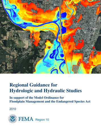
Another consideration for the selection of models is the level of precision that is required for theresults. In many instances, a less precise hydraulic method will still provide sufficient detail formapping floodplains, especially if appropriately conservative assumptions are made during themodeling and mapping steps.Regional GuidanceGuidelines and Specifications suggests the use of steady 1D models, except when conditions aretoo complex for these models to provide satisfactory answers. More complex hydraulicapproaches are used when there is reason to believe that a steady 1D model will not produce areasonable estimate of the base flood elevation. This guidance can be found in Section C.3.4 ofGuidelines and Specifications.This Regional Guidance provides more specific advice for applying different models, but is notintended to supersede the technical requirements for applying a specific model provided in therevised Appendix C to Guidelines and Specifications.An unsteady 1D model was used by the Corps of Engineers to develop flood mapping for the UpperChehalis River. The Chehalis valley near Chehalis and Centralia is a hydraulically complex area thatincludes the confluences of several major tributaries and significant floodplain storage volume. Oneproduct is this map showing flood depths. The use of an unsteady 1D approach in this location hasadditional benefits in terms of supporting the design and analysis of potential flood mitigationmeasures. NHCNFIP-ESA H&H Guidance 11 January 2010
Assessing the hydraulic aspects of the channel and floodplain: Several elements of theBiological Opinion focus on requiring that the NFIP include measures to avoid, minimize, andmitigate potential impacts to floodpla
There are normally three major phases to a FEMA flood study of a stream or river: 1. Assess the flows (usually involving a hydrologic study) 2. Determine flood elevations and the floodway (via a hydraulic analysis) 3. Map the floodplain (SFHA) and floodway Flood studies conducted for the N