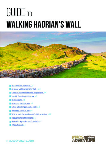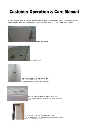
Transcription
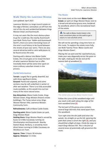
Mike’s Bristol WalksWalk Thirty-Six: Lawrence WestonThe RouteWalk Thirty-Six: Lawrence WestonOur route starts at the main Blaise CastleEstate car park on Kings Weston Road, next toa broad and attractive grassy area, borderedby woodland, which is the recreational heartof the estate.Last updated: April 2021Lawrence Weston is a large council estate onthe edge of Bristol, somewhat cut off from therest of the city and sandwiched between KingsWeston Down and Avonmouth.The café at Blaise Castle Estate is themost convenient place on this walk to get asnack or a non-alcoholic drink.It may not seem like the most obvious placeto go for a walk but, like nearby Avonmouth(see Walk Thirty-Four ‘Hallen and AvonmouthNorth’), there are some interesting traces ofthe area’s rural history to be found betweenthe streets of post-war semis. There are alsoseveral attractive wild or semi-wild places tobe found across the area.We will not be spending a long time here onthis route. To explore the estate more fully,see Walk Twenty-Three ‘Blaise Castle andKings Weston Down’.Placing the car park and the road behind you,make your way diagonally across the grass tothe right, making for the far end of thenearest belt of woodland (1).Starting with a detour into Blaise CastleEstate, this circuit goes on to reveal the bestof what Lawrence Weston has to offer.Inevitably there will be some time spent onmore ordinary suburban streets in theprocess.Useful InformationTerrain: Largely flat or gently downhill, butwith three significant climbs.Ground: Paved and unpaved, and somesections may be soft underfoot in winter orafter wet weather. There is no fully accessibleroute available, as this would miss out toomany of the more natural areas.The initial view across Blaise Castle EstateKey Attractions: Blaise Castle Estate, KingsWeston Down, Kings Weston (historic estatebuildings), The Tump nature area, KingsWeston Roman Villa, Lawrence WestonCommunity Farm.Follow the curve of the woodland edge untilyou reach a dirt path along the edge of thenext woodland area (2).The last part of the grassy area containsseveral large old trees that stand apart fromthe woodland.Refreshments: Café at Blaise Castle Estate.Starting point: Blaise Castle Estate car park,Kings Weston RoadGetting there: Kings Weston Road is served bybuses to Cribbs Causeway running viaShirehampton and Avonmouth. NearbyStation Road, Henbury, is served by moredirect buses running to Cribbs Causeway viaWestbury-on-Trym.Turn right onto the dirt path and enter thewoods. Go straight on up the hill, ignoring thepath that comes in from the right (3), and youshould find a flight of steps. Climb the steps toreach Kings Weston Hill. This is the first ofseveral areas of potentially soft ground on thisroute.Approx. Time: 2 hours 30 minutesApprox. Distance: 5.5 miles1
Mike’s Bristol WalksWalk Thirty-Six: Lawrence WestonThe steps to Kings Weston HillThe path down into the woods from KingsWeston DownThe open area at Kings Weston Hill was anIron Age hill fort. The remains of theearthworks are visible ahead of you. The hill ispart of a prominent landscape ridge that issometimes known as Kings Weston Down.The path turns into a pleasant woodlandtrack, which is home to a few bluebells in thespring. This is another area where the groundmay be soft at certain times of year.The track descends through the woodstowards Kings Weston Road, eventuallypassing a horse paddock on the right (5).Kings Weston HillMake your way along the open area of thedown.Horse paddock at Kings Weston RoadWalk Twenty-Three ‘Blaise Castle and KingsWeston Down’ explores this area more fully,but we are just using it to avoid a section ofthe main road and will soon be heading downinto Lawrence Weston.Reaching the main road, Kings Weston Road,cross over and go straight on down FernhillLane.Fernhill Lane is the pleasant route by whichwe will penetrate the Lawrence Westonhousing estate for the first time. One of theold country lanes that still survive within thedevelopment, this one retains most of itshistoric character, with fields, woodlands andstone walls.As you leave the hillfort, there are two smallclumps of native scrub in the middle of thegrassy area. A public footpath crosses the topof the hill just beyond the second clump ofscrub, before you get to a line of freestandingtrees.Turn right onto this footpath, heading downinto the woods next to a wooden bench (4).2
Mike’s Bristol WalksWalk Thirty-Six: Lawrence WestonAt the end of the level section of OakhangerDrive, bear left onto the cul-de-sac MeereBank (8).Meere Bank continues the grass-edged designof the estate.At the end of the cul-de-sac, take the paththat leads down into a small green space atthe right-hand corner. Bear left past a largetree to enter an area of woodland via a smallpedestrian gate (9).Fernhill Lane, Lawrence WestonYou will eventually reach a junction next to afew pretty old houses (6). Ahead, FernhillLane ends at a dead end next to BroadlandsDrive.Turn left before the dead end section, ontoCommonfield Road.The hidden gate into the woods at MeereBankEntering an area of bluebell woods, you willreach a footpath crossing from left to right. Amarker post identifies it as the ‘Severn WayBristol Link’ (10).Turn right onto the Severn Way Bristol Link,climbing very steeply uphill. Once again, theground may be soft here.Entering the estate: Commonfield RoadCommonfield Road is typical of the upperpart of Lawrence Weston. The houses areextremely ordinary, but they are separated byan attractive grassy bank. This will be arecurring feature of the next part of the walk.Reaching a crossroads, turn left to climbOakhanger Drive.There are gaps in the townscape aroundOakhanger Drive where properties have beendemolished. The gaps are due to be filled withnew houses in the near future.Turn right up the Severn Way Bristol LinkFor now, enjoy the view back up towards thewoods of Kings Weston Down as the climblevels off and you make your way along theupper edge of the estate (7).The winding path will eventually bring you outin a large field below Napier Miles Road.Make your way along the right-hand edge ofthe field.3
Mike’s Bristol WalksWalk Thirty-Six: Lawrence WestonAs you walk along the field, you will get aninteresting view out towards the SevernEstuary, including Royal Portbury Dock andPortishead beyond.The footpath through the woods on the edgeof the Kings Weston House estate makes apleasant alternative to the busy anddangerous road below. You will rejoin a moreconventional pavement after you cross theend of Mancroft Avenue.Kings Weston Lane is another of the oldcountry roads through this area, but it has notretained all its character, extensively widenedand redeveloped more than once since itsrural origins. However, on the left you will stillfind the imposing stone buildings of HomeFarm (13).View to the Severn Estuary from Kings WestonBefore you reach the far end of the field, crossto the left-hand corner to exit via a gate ontoNapier Miles Road (11). Turn right.Napier Miles Road is home to a collection ofunique historic buildings. You are close toKings Weston House here (see Walk ThirtyTwo ‘Shirehampton and Kings WestonHouse’), but any historic connection with theestate is now unclear.Home Farm, Kings Weston LaneAt the lower corner of Home Farm, turn leftonto Barrowmead Drive and immediately rightonto Moor Grove.On the left, a walled pond flanked by derelictlodges conceals a Georgian house that is nowused by Kings Weston School. On the right,you will find a particularly fine stable blockwhich has been converted to homes.Moor Grove is another typical LawrenceWeston street, but it is elevated from thetotally mundane by the attractive belt of treesthat winds down the right-hand side. As youdescend the hill, you may catch a distantglimpse of an old mill at Avonmouth docks.Turn left onto a footpath just after No.36Moor Grove, which runs to the rear of a row ofhouses that sits at right angles to the street(14).The footpath leads to The Tump, a naturearea lined with trees and scrub. Keep an eyeout for butterflies and birds.Stable block, Napier Miles RoadContinue to the end of Napier Miles Road,reaching Kings Weston Lane. Carefully crossthe road and turn right, following the raisedfootpath above the carriageway (12).4
Mike’s Bristol WalksWalk Thirty-Six: Lawrence WestonCross, turn left across a grassy area towards afenced compound (17).This part of Long Cross is not an attractivestreet, but it is home to a unique historicfeature: the fenced compound contains theremains of Kings Weston Roman Villa. Theoutlines of several rooms can be seen, as wellas the remains of a hypocaust (a Romanunderfloor heating system).The Tump, Lawrence WestonFollow the path through the Tump until youemerge on Badenham Grove. Bear lefttowards a sloping grassy square (15).The steep grassy square at Barrowmead Driveand Moorend Gardens provides a pleasantfocal point to this part of the housing estate.Turn right along Barrowmead Drive and thenleft up Moorend Gardens. At the first corner,take a pedestrian gate leading to MancroftPark.Kings Weston Roman VillaMake your way past the red brick houses atthe back of the villa, then join the main road.Cross over at the traffic island and then turnright down a scruffy lane that runs between ablock of flats and the Longcross Garage (18).The lane itself is rather unpleasant, but it willconnect you to the next part of our route: awalk along the edge of the wilderness areajust outside Lawrence Weston.You will connect with a cycle path that headsoff in two directions (19).Turn right along the cycle path.Mancroft Park, Lawrence WestonMancroft Park is a decent children’splayground that benefits from an attractiveposition below Penpole Wood (see WalkThirty-Two ‘Shirehampton and Kings WestonHouse’).Take the path to the left of the children’s playarea and then bear right across the unfencedarea to join Mancroft Avenue (16).Make your way down Mancroft Avenue andtake the first right, Windcliff Crescent. Justbefore you come out on the main road, LongThe path along the edge of Lawrence Weston5
Mike’s Bristol WalksWalk Thirty-Six: Lawrence WestonThe cycle path is a greenway of sorts that runsalong the edge of the Lawrence Westonestate. This first section is bounded by agrassy area on the right and Lawrence WestonSkate Park on the left, a popular local facility.When you reach the back of the flats onHenacre Road, the path is (at time of writing)blocked by a construction site.Bear left and walk on the grass along thewoodland edge (20).The construction site is not especiallyattractive, so turn your attention to thewoodland and scrub on the left in search ofwildlife.The footpath next to Lawrence WestonCommunity FarmThe pleasant path will give you a glimpse ofsome of the community farm’s inhabitantsbefore taking you out into an area of wildscrub to the rear of St. Bede’s Catholic College(23).After a while, you will come back out on KingsWeston Lane.Cross Kings Weston Lane. Turn right and thenleft onto Campbell Farm Drive. Immediatelyturn left onto a gated service road, whichprovides access to the next section of the cyclepath (21).Follow the path, going generally straight on,but bearing right at any junctions, so that youcircle St. Bede’s’ extensive grounds.This patch of wasteland serves as a sort ofinformal wildlife area. Before long you willfind yourself walking next to the M5Motorway beside a row of tall poplar trees.The cycle path beyond Campbell Farm DriveThe next section of the cycle path runsthrough a slightly wilder area at the back ofSaltmarsh Drive. After a while you will reach afootpath leading into Lawrence WestonCommunity Farm on the left, which you maywish to visit.The wildlife area next to the M5When a bridge over the M5 rises ahead ofyou, blocking your way, follow the path roundto the right so that you head away from theMotorway. You will eventually come out on aclosed section of Lawrence Weston Road (24).Facing the entrance to Lawrence WestonCommunity Farm, bear right onto a footpaththat leads between some of the animalpaddocks (22).Lawrence Weston Road is another of the oldcountry roads across this area. It runs all theway from Blaise Castle Estate (almost), downthrough Lawrence Weston itself and out intothe modern trading estates of Avonmouth.6
Mike’s Bristol WalksWalk Thirty-Six: Lawrence WestonHowever, large sections of it are closed tothrough traffic. This particular sectionprovides a pedestrian and cycle link over theM5. We explore the Avonmouth section inWalk Thirty-Four ‘Hallen and AvonmouthNorth’.Spring colours in Long CrossThe next section of Lawrence Weston Roadhas lost all of its original buildings, but castyour eyes to the right at the junction of KnovillClose for a glimpse of another historicremnant, Aust Farm House (26).After the left-hand bend onto BeverstonGardens, go through the gates into a smallpocket park (27).The closed section of Lawrence Weston Road,looking towards Avonmouth.Turn right along the closed section ofLawrence Weston Road until you come out ona much wider section lined with houses (25).Continue along Lawrence Weston Roadtowards the main road.Pocket park at Beverston GardensWe will be following the fragments ofLawrence Weston Road for a while, lookingfor historic interest. This stretch is home toone large older property, Willow TreeCottage.Make your way across the green space toreach a short, closed section of LawrenceWeston Road. Turn left, then right onto yetanother section of Lawrence Weston Road,climbing up the hill (28).Reaching the main road, Long Cross, turn leftbriefly and then turn right into the nextsection of Lawrence Weston Road.This final section of Lawrence Weston Roadclimbs up towards an area of woodland calledthe Greenhill Plantation. You may wish totake the raised footpath above the grassybank on the left.About halfway up the hill, you will find UpperTerrace, an odd historic survivor. It once had alower counterpart, now long gone.7
Mike’s Bristol WalksWalk Thirty-Six: Lawrence WestonUpper Terrace, Lawrence Weston RoadAt the top of the main climb, LawrenceWeston Road turns to the left at the corner ofQuarry Lane (29).Alternative routeThe next part of the main route involves asteep and slightly treacherous path with anunfenced drop-off at one point. The path isbest avoided in wet conditions.The unsigned path up from Quarry LaneBeware, as the unsurfaced path is very steepand could be dangerous when wet.To avoid the hazard, continue up LawrenceWeston Road, passing another old stonecottage. Continue straight on until you gothrough a barrier onto De Clifford Road.After climbing steeply for a while, you willpass an unfenced drop-off down to thegardens on the right. The path heads up thehill for a short while longer, allowing you toclamber out onto Greenhill Lane (31).Turn right along De Clifford Road and, at theend of the road, go straight on along afootpath to come out on the main road, KingsWeston Road, opposite the entrance to BlaiseNursery. Carefully cross the busy road torejoin the main route at the corner of BlaiseCastle Estate (32).To continue along the main route, turn rightonto Quarry Lane. Just after the first block offlats, take the steep, unsigned footpath to theleft of two driveways (30).Greenhill LaneA rustic backwater with a few scatteredhouses, Greenhill Lane winds around the backof the Greenhill Plantation, giving you a closerview of the trees, until it eventually comes outon Kings Weston Road.Carefully cross the busy road and turn left.Follow the pavement until you reach the8
Mike’s Bristol WalksWalk Thirty-Six: Lawrence Westonentrance to Blaise Nursery (32). Thealternative route rejoins the main route here.Next to the entrance to Blaise Nursery, youcan re-enter the main grassy area of BlaiseCastle Estate.Returning to Blaise Castle EstateEnter the grassy area, skirting the trees thatfollow the road and, finally, make your wayalong the lower edge of the grassy area toreturn to the Blaise Castle Estate car park andcomplete Walk Thirty-Six.9
Mike’s Bristol WalksWalk Thirty-Six: Lawrence WestonMap: Walk Thirty-Six: Lawrence Weston10
The path down into the woods from Kings Weston Down The path turns into a pleasant woodland track, which is home to a few bluebells in the spring. This is another area where the ground may be soft at certain times of year. The track descends through the woods towards Kings Weston R