Transcription
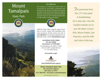
MountTamalpaisState ParkOur MissionThe mission of California State Parks isto provide for the health, inspiration andeducation of the people of California by helpingto preserve the state’s extraordinary biologicaldiversity, protecting its most valued natural andcultural resources, and creating opportunitiesfor high-quality outdoor recreation.The panorama fromthe 2,571-foot peakis breathtaking.On a clear day, view theFarallon Islands out toCalifornia State Parks supports equal access.Prior to arrival, visitors with disabilities whoneed assistance should contact the park at(415) 388-2070. If you need this publication in analternate format, contact interp@parks.ca.gov.CALIFORNIA STATE PARKSP.O. Box 942896Sacramento, CA 94296-0001For information call: (800) 777-0369(916) 653-6995, outside the U.S.711, TTY relay servicewww.parks.ca.gov SaveTheRedwoods.org/cspMount Tamalpais State Park801 Panoramic HighwayMill Valley, CA 94941(415) 388-2070 · www.parks.ca.gov/mttamalpais 2007 California State Parks (Rev. 2016)sea, the Marin Countyhills, Mount Diablo, SanFrancisco, and the hillsand cities of the bay.
This was later changed to the Miwok wordtamalpais (tam-al-pie-us), which, roughlytranslated, means “bay mountain” or“coast mountain.”CULTURAL HISTORYNative PeopleThe Coast Miwok lived on or near MountTamalpais, staying near water sourcesthroughout present-day Marin County. TheseNative Californians hunted small animalsand deer, collected acorns, and gatheredflora, marsh plants, and shellfish. They madebaskets and clamshell disk beads, tradingthem for locally unobtainable resources,such as high-grade obsidian from LakeCounty tribes. The Coast Miwok had a richculture and a complex and intricate language.However, their way of life changed soon afterthe arrival of Europeans.In 1770 two explorers, Captain Pedro Fagesand Father Juan Crespí, named the mountainLa Sierra de Nuestro Padre de San Francisco.Mount Tamalpais Scenic RailwayResidents of San Francisco, whose populationexploded after the 1848 gold discovery, usedMount Tamalpais for recreational purposes.Trails were developed, and a wagon road wasbuilt to the top of the mountain in 1884.The Mount Tamalpais Scenic Railway,completed in 1896, carried visitors to themountaintop and the Summit Tavern, ahotel and restaurant. The slope from MillValley to the summit was so steep thatthe railroad had to negotiate 281 curves,equivalent to 42 complete circles, billingitself as the “Crookedest Railroad in theWorld.” In the section known as the“Double Bow Knot,” the track paralleleditself five times within 200 yards. In1907 the “gravity car” was designed totransport visitors from the top of themountain to the redwood-filled canyonof Muir Woods. Requiring only gravityand a brake, open-air rail cars carriedpassengers down the mountain toMuir Woods at an exhilarating 12 mph.The railroad and gravity cars allowedsightseers to travel from Mill Valley tothe summit, down to the Woods, andback to Mill Valley.The Scenic Railway’s famous gravitycars were popular until the advent ofthe automobile and the construction ofRidgecrest Boulevard in 1925. A gravitycar replica is displayed at the GravityCar Barn on East Peak.Conservation EffortsOver the years, millions have flocked tothe mountain, affectionately called “MountTam,” to relish the spectacular views andhike its trails. Generations of Mount Tamenthusiasts have worked hard to protectthe mountain and keep it open to thepublic. The oldest of these citizen groupsis the Tamalpais Conservation Club,organized in 1912. In 1928 William Kent, anardent Marin County conservationist, andhis wife donated 200 acres of land in SteepRavine to help create Mount TamalpaisState Park. The park was later enlargedthrough the efforts of several hikingclubs, led by the Tamalpais ConservationClub. These organizations orchestrated agrassroots campaign to purchase additionalland for the state park.Gravity car on Mount Tam’sScenic Railway, ca. 1900
THE STATE PARK TODAYNow one of the oldest and most popularunits of the California State Park System,the park has grown to 6,300 acres.Completely surrounding Muir WoodsNational Monument, the park is borderedby Marin Municipal Water District land onthe north and by the Golden Gate NationalRecreation Area on the northwest and south.NATURAL HISTORYGeologyMany people think the 2,571-foot peak isthe remnant of an extinct volcano. However,geologists believe that Mount Tamalpaiswas created due to its location near theSan Andreas Fault, one of the world’s mostactive faults. Over time, the mountain hasrisen from the earth’s crust, while erosionhas left only solid rock exposed in thehighest peaks and ridges.Common rock types here are graywacke(sandstone), shale, greenstone, chert, quartztourmaline, and the easily identified greenserpentine, California’s official state rock.Plant LifeThe varied topography and soils of thepark support a tremendous diversity ofplant life. More than 750 plant species canbe found in the park. Hikers pass throughopen grassland, chaparral, and oak-coveredknolls, or they descend through densestands of Douglas-fir and California laurelinto deep, fern- and redwood-filled canyons.In spring the slopes of Mount Tamcome alive with the vibrant colors ofwildflowers. Hillsides are sprinkled withCalifornia poppies, lupines, Douglas irises,goldfields, and shooting stars. Spottedcoralroot, fetid adder’s tongue, and Pacifictrillium are among the plants that hide in thedeep shade of the forest.The Redwood ForestMount Tam’s legendary Steep Ravine Trailleads hikers along Webb Creek througha stand of tall redwood trees. The soundof rushing water prepares visitors for thefragrance of damp earth and the sight offerns along the creek’s banks. The redwoodsform a canopy above the water cascadingover the rocks. Alongside the cascade, hikersmust climb a steep ladder to return to thebeginning of this beautiful trail.Although the park can be foggy year round,some scientists are concerned that increasedtemperatures and decreased fog due toclimate change may threaten the survival ofthe coast redwoods environment.Animal LifeRaccoons, gray foxes, squirrels, bobcats,coyotes, black-tailed deer, and mountainlions sometimes roam the slopes. Bearsand elk once wandered the land, but theyvanished as a result of hunting and ranchingbefore the park was established.Birdwatchers can view more than 150species of birds within or very near thepark. Red-tailed hawks, northern harriers,and turkey vultures soar over the opengrasslands by day, while the sounds of greathorned, spotted, barnand screech owls fill thenight. The hollow drillingof pileated, acorn, andhairy woodpeckers addsto the forest sounds. Alongthe coastline, there arenumerous oceanic andintertidal birds to identify.Red-tailed hawkRECREATIONHiking — Hikers enjoy more than 60 milesof park trails, connecting to a 200-mile trailsystem over land managed by the MarinMunicipal Water District and the GoldenGate National Recreation Area.Cycling — Road bikers are challenged bythe infamous Seven Sisters climb and thetwisting road to the top. Mountain bikers canenjoy the Coast View and Dias Ridge multiuse trails as well as park fire roads.Day Use — Bootjack, on Panoramic Highwayeast of Pantoll, has picnic tables for up to 50people, stoves, water, and flush toilets.East Peak summit has picnic tables, anaccessible restroom, and a visitor centerstaffed on weekends.
a small wood stove, picnictable, sleeping platforms, andan outdoor barbecue, butno running water. Restroomsand water faucets are nearby.Reservations are required.The Alice EastwoodGroup Camp, located on thePanoramic Highway near theMountain Home Inn, has twosites for organized groups of25 to 50 people. Both sitesSpectacular views of the San Francisco Bay area canhave tables, grills, and abe seen from the Verna Dunshee Trail near East Peak.large tent spot.Frank Valley Group HorseMountain Theater — The 3,750-seatCamp, on Muir Woods Road about one milenorth of Hwy. 1 at Muir Beach, has tables,Mountain Theater, officially named thefire rings, drinking water, pit toilets, horseCushing Memorial Amphitheatre, was builttroughs, and corrals for up to 12 horses.of natural stone in the 1930s by the CivilianVisit www.parks.ca.gov/mttamalpais orConservation Corps at Steep Ravine.call (800) 444-7275 for campground and cabinEach spring since 1913, the Mountainreservation information. Reservations may bePlay Association theatrical company hasmade seven months in advance.presented outdoor productions of Broadwaymusicals. For dates and reservations ofINTERPRETIVE PROGRAMSMountain Theater performances, contact theAt East Peak, a visitor center and recreatedMountain Play Association at (415) 383-1100.Gravity Car Barn are open as volunteerTo hold special events in the park, see thestaffing allows. At the Mountain Theater,park event application at www.parks.ca.gov.free astronomy programs with telescopeCamping — Bootjack and Pantollviewings take place on select Saturdaycampgrounds, on Panoramic Highway, eachnights April through October. Elsewhere onhave 15 first-come, first-served sites about 100the mountain, guided hikes are offered yearyards from the parking area. Both campsitesround. Visit www.parks.ca.gov/mttamalpaisoffer drinking water, firewood, and restroomsor www.friendsofmttam.org for details andwith flush toilets. There are no showers.links to interpretive programs and events,Rocky Point /Steep Ravine Environmentalsuch as free guided weekend and moonlightCampground, on a marine terrace one milehikes. Inquire at the Pantoll Ranger Kiosksouth of Stinson Beach, has seven primitiveabout self-guided hikes and ranger-ledsites and nine rustic cabins. Each cabin hasprograms for schools and other groups.ACCESSIBLE FEATURES The accessible half-mile Verna DunsheeTrail at East Peak has fantastic bay views.Accessible tables, restrooms, and drinkingfountains are nearby. Spectacular vistas may also be seen froman accessible .4-mile portion of the OldMine Trail from Pantoll Station and .25miles of the McKennan Trail. Pantoll and Bootjack each have accessiblecamping, restrooms, and parking. Cabin #1 and environmental campsite #7at Steep Ravine are accessible. The Mountain Theater has a wheelchairplatform on the right side of the theater. The Mountain Play Association offerssigned performances and descriptiveservices during the first three playperformances each season. For moreinformation, call the Mountain PlayAssociation at (415) 383-1100.
RoadFireFFianIndR o ad800oo–KFireTrailde400raoKo1600Viceko Go ra dE-o inaCamp Ave800TrailTouristClubaynu eSunTraaFourCornersPaM iruilSFBay400DipseaTraildhwOAKLANDEdgewoodAvenueto DowntownMill Valleyoia Valley RoaSe q udHig2480101yBerkeleyAngelIsland SPSAN FRANCISCOOceandooTiburon1Golden GateNRARo400raile l ine TWoodsTrailEl dlkTra iCreen o r am i cTrail800dDipseaHomesteadHill TrailHomestead HillFire Road400800nto Hwy. 1011LoneD ias04000Spur TrailkayeeH ig h wCr40S TAT E40TaPu verm dleUpper Ferna ilE a st Ri0024Mi des idrt hNoBlstcreriRidg eSpRo c kTrailR &HRaTrailringSpC o li e rWestitasgunLaTrailin gSprRock-asL a gu ni tuntain Top TrailMotE asevinRapeeFireit aL ag u nForkckRoTrailStCanopyCr e e kkinocisD avPTrailasDi800MR o adGOLDEN0Fire400ne40GGNRA800el iorok400Re dG AT E1woodPPacificWay1KaasiFire Road GreenMUIR BEACHPto Coastal TrailGreen GulchFarm andZen CenterR E C R E AT I O NMiddle GreenGulch Trail(bikes uphill only)RidgeayMuir BeachOverlookDiaslchHighwSouth EntranceN AT I O N A LAREACoyo teekGuneGGNRATraileCr0irel40Sh oraill TSamuel P. Taylor State Park15 miles west of San Rafael on Sir Francis Drake Boulevard(415) 488-9897800ShiwPA R K400offTrailHighwaykeeCreRidgdooSlideRanchChina Camp State ParkFour miles east of San Rafael on San Pedro Road(415) 456-0766iladwdstCuNEARBY STATE PARKSAngel Island State ParkIn San Francisco BayFerries from Tiburon / Vallejo/San Francisco(415) 435-5390RoHeatherGullRockOwPLEASE REMEMBER The park is open from 7 a.m. to sunset. All natural and cultural park resources are protected by lawand must not be disturbed or removed. Camping and fires are permitted only in designated areas. Except for service animals, leashed dogs are allowed only onpaved roads in developed areas, family campgrounds, andpicnic areas. Dogs must be confined to a vehicle or tent at night. Horses and bicycles are allowed only on fire roads andposted hiking trails. Be alert for poison oak, rattlesnakes, mountain lions, and ticks. Bus transit serves the park. Visit www.marintransit.org or call511 or (415) 526-3239 for schedules and stops.ooWMuirTraildSt1 Mile1.5 Kilometers0Tra40Frank ValleyGroup HorseCampgroundViewldCoRem400C o as tRockyPoint TrailR idge1Rocky Point-Steep RavineEnvironmental CampgroundEast EntrancelTraiRocky Pointey)Vall800400(FrankPM iw okSteep Ravine Cabinsre ailStTrailHelen00pTrail12NovatoRidg eH ig wh a400lchad2915 Kilometers10PiGuRoNapa121580icke5Samuel P.Taylor SPEdgewoodAvenuedwdth0ePanoramicTrailReoaBlivD ri2911610 Miles5Mt Tamalpais SPmainMFire RdtCascaderailHill 640sWe12SonomaPa800Fireed0400ReR101Monument HQRo800800dramitnoeeedumwCrthroadSRailroanointR i d geilFireBl iRailaTrRoadMuir WoodsVisitor CenterntledalPalRdalchOlTrelpGudmTedayoeeTrOl dTrailHillsideTrailBohemianGroveFireko-DoubleBow KnotKentMemorialParCaere00800TraFern CreekwerLotn Cut woodSpur TraikWhiteGate0dPleviEa sTrailKeHoFireTrail0GRoadRBohemianGrove Trailer200TrailRack Firegbd loodAv enu ePooTraileLostMUIR WOODSN AT I O N A iacHillHaThrockmortonFire StationilTraBen Johnson TrailDipr F irCFernTrailedtraJoh nsonBenlveldTrenkMcKCr e e400R oadTrau n i t asneLageTrailC remBenchLadderpeoa di ra80p400Roa12r eek TrestleeTrail800BuLone TreeSpringadderksideike00ooTrAlicSpoCr e e kBon ake16taG 0ireD un shee2400Fire LookoutEast Peak00DaMattt t le sdw tja ckoodPantollCampgroundTCCP20iTraie wThis park is supported in part through theFriends of Mt. TamP.O. Box 7064, Corte Madera, CA 94976(415) 258-2410 www.friendsofmttam.orgramaisSt a t e Pa r kePOlsth 2010 California State Parks (Rev. 2016)NolerPanoRaCTCGravityCar BarndeTrailRoadacViewpointGr a16001200c kyBeSpringilroad012ReilTraaddgR o adeRadvisRanger StationRestroomsRoMilDaVan WyckMeadowPrCoacRoaCRoRo001600InspirationPointGr a dVisitorCenterR oadPantoll RangerStation Park HQ800daMiddle Peakr ai lra TNoWest PointInnilRekPicnic AreanParkingaLocked GateeExhibitPTrailuSpaTrcPe1200irelpTamaBle stcrFiredMSRed RockTraildek00ktk Fi ra ilitjacaBootjackCampgroundandDay UseTCCwer O l d Min eLooDe er P a r k F i r e RifTrailaTrR rie wke vLa TrailTrail20ila16Moun2400aTrPselilTrath s i d eColierSpringedgWest Peak0eDipeicra mcCampground: HorseoPan8001OCampground: GroupPMattWestEntrancenBGraMinoBooOldslOld AirForceStationtOld SyhCampground: EnvironmentalUpp e rForbesBench2000MountainTheater Fire TrPan tollTrail0TA M A L PA I SaTraior2000er nInt lcDrinking undUSGS BM2040ft622mdock Table RockleaAccessible FeatureBlvRidgecrestStinson BeachFire StationTrail: Hike & HorseAccessible Trail (Hiking Only)00STrail: HikeTrail: Hike, Bike & HorsebTaMaevd20Fire Road: Hike, Bike & HorseAveHwyMajor RoadPaved RoadereSTINSONBEACHsi ddGraRock SpringPC r ee ktHang GliderRi Site #2adLa g uni ta sacedrr a lo n eLegendo400a FaroyTrailtarBel vAr2000Hang Glider Site #1niddeeekWestTrailrt hMount TamalpaisE l d r i dg ekt00NoRifle ARoFireTrojan eAvRoplowdriftadCaaDTra001600L o w dFlatsmasseanBallou PointB o li ayMurphy’sBridge8001lnasilRdAREACreekke1200to Bolinas andPoint ReyesL a u reDeSimmonsHang GliderTr Site #3anBolinaMicileFir R ontstein1925ft587mRidTraWAT E RBarth’sTwin tFallsts1600R E C R E AT I O N40cresKeTrailStrkilro TrartuMcKennanGulch TraillchnaGuliBo800geLaurelDell1800ft548mil40adM i d dl eMarshOldRoilTraidBenchBare KnollFonttesRrsMoTratWesN AT I O N A Lchsttr y00HighlGuCrossra161600unForkM U N I C I PA LcG AT EKeCoCat TraFo120BsnaoliMidMARINardgidAU D U B O NCANYONRANCHleveBou1600eF tge8000edeesRidrf ax RoadSwBoli nasFa iW12TrailELakeKentgMarktri nAlpineekE as tCre800North EntranceBo800it a sSpLa g u nTra il800
La Sierra de Nuestro Padre de San Francisco. This was later changed to the Miwok word tamalpais (tam-al-pie-us), which, roughly translated, means “bay mountain” or “coast mountain.” Mount Tamalpais Scenic Railway. Residents of San Francisco, whos