Transcription
U.S. Department ofHomeland SecurityUnited StatesCoast GuardLIGHT LISTVolume VIPACIFIC COAST AND PACIFIC ISLANDSPacific Coast and outlying Pacific IslandsThis publication contains a list of lights, soundsignals, buoys, daybeacons, and other aids to navigation.IMPORTANTTHIS SHOULD BE CORRECTEDEACH WEEK FROM THE LOCAL NOTICES TO MARINERSOR NOTICES TO MARINERS AS APPROPRIATE.2019COMDTPUB P16502.6
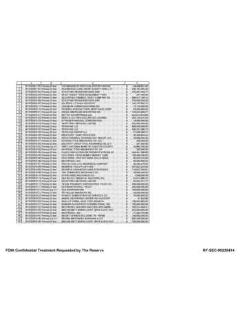
20O40OHAWAIIAN ISLANDS180O160O140OAIDS TO NAVIGATION MAINTAINED BY UNITED STATES AT OTHERPACIFIC ISLANDS ARE INCLUDED ON THE PACIFIC LISTMIDWAY ISLANDSVOL. VIPACIFIC COASTAND PACIFIC ISLANDS120O100O(Econfina River, FL to Rio Grande, TX)VOL. IVGULF COASTVOL. VMISSISSIPPIRIVER SYSTEM100O80OVOL. VIIGREAT LAKES80OVOL. I60OAids maintained atPuerto Rico, Virgin Islands,and Guantanamo Bayincluded in Volume III.(Little River, SC to Econfina River, FL)ATLANTIC COASTVOL. III(Shrewsbury River, NJ to Little River, SC)VOL. IIATLANTIC COAST(St. Croix River, ME to Shrewsbury River, NJ)ATLANTIC COAST60O20O40O50O120O50O140O60O160O60O180OU.S. COAST GUARDLIMITS OF LIGHT LISTS PUBLISHED BY
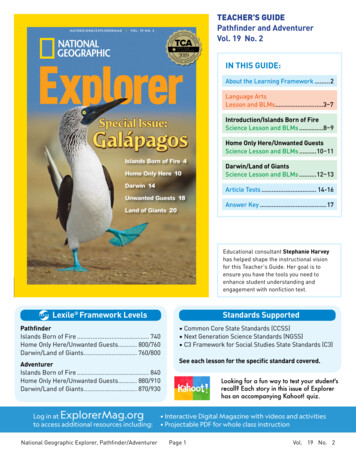
U.S. AIDS TO NAVIGATION SYSTEMTED STNID1790GUARSTES COAATon navigable waters except Western RiversULATERAL SYSTEM AS SEEN ENTERING FROM SEAWARDPORT SIDEODD NUMBERED AIDSPREFERRED CHANNELNO NUMBERS - MAY BE LETTEREDPREFERRED CHANNELNO NUMBERS - MAY BE LETTEREDPREFERREDGREEN LIGHT ONLYCHANNEL TOFLASHING (2)RED LIGHT ONLYFLASHING (2)ISOOCCULTINGREDGREENQUICK FLASHINGFLASHINGTOPMOST BANDTOPMOST BANDOCCULTINGPREFERREDCHANNEL TOPORTSTARBOARDFLASHINGSTARBOARD SIDEEVEN NUMBERED AIDSGREEN LIGHT ONLYQUICK FLASHINGISORED LIGHT ONLYCOMPOSITE GROUP FLASHING (2 1)COMPOSITE GROUP FLASHING (2 1)9"1"FI G 6sG "9"FI G 4sLIGHTGR "A"FI (2 1) G 6sLIGHTED BUOY"2"FI R 6sLIGHTRG "B"FI (2 1) R 6sR "8"FI R 4sLIGHTED BUOY9G"5"GC "9"CANGR"U"RGN "C"GRC "S"DAYBEACONRN "6"RG"G"NUNNUNCANR"2"DAYBEACONAIDS TO NAVIGATION HAVING NO LATERAL SIGNIFICANCEISOLATED DANGERNO NUMBERS - MAY BE LETTEREDSAFE WATERNO NUMBERS - MAY BE LETTEREDWHITE LIGHT ONLYWHITE LIGHT ONLYFI (2) 5sMORSE CODEMo (A)RW "N"Mo (A)LIGHTEDAND/OR SOUNDCBR "A"FI (2) 5sRW"A"MRBR "C"UNLIGHTEDAND/OR SOUNDRANGE DAYBOARDS MAY BE LETTEREDKGWLIGHTEDRW "N"RWSP HTEDDAYBOARDS - MAY BE LETTEREDWHITE LIGHT ONLYNRNGSPECIAL MARKS - MAY BE LETTEREDNBYELLOW LIGHT ONLYFIXEDFLASHINGRWBnGWBnBWBnYC "A"YN "C"Y "A"BnUNLIGHTEDAids to Navigation marking theIntracoastal Waterway (ICW) displayunique yellow symbols to distinguishthem from aids marking other waters.Yellow triangles indicate aidsshould be passed by keeping them onthe starboard (right) hand of thevessel. Yellow squaresindicate aidsshould be passed by keeping them onthe port (left) hand of the vessel. Aprovidesyellow horizontal bandno lateral information, but simplyidentifies aids as marking the ICW.SHAPE OPTIONAL--BUT SELECTED TO BE APPROPRIATEFOR THE POSITION OF THE MARK IN RELATION TO THENAVIGABLE WATERWAY AND THE DIRECTIONOF BUOYAGE.Y "B"FILIGHTEDTYPICAL INFORMATION AND REGULATORY MARKSNWINFORMATION AND REGULATORY MARKERSWBnWHEN LIGHTED, INFORMATION AND REGULATORYMARKS MAY DISPLAY ANY WHITE LIGHT RHYTHMEXCEPT QUICK FLASHING, Mo(A), AND FLASHING (2)BOATEXCLUSIONAREASWIMMOORINGBUOYWHITE WITH BLUE BANDMAY SHOW WHITEREFLECTOR OR LIGHTDANGERROCKSLOWAREANOEXPLAINATION MAY BE PLACEDOUTSIDE THE CROSSED DIAMONDSHAPE, SUCH AS DAM, RAPIDS,SWIM AREA, ETC.MULLET LAKETHE NATURE OF DANGER MAYBE INDICATED INSIDE THEDIAMOND SHAPE, SUCH AS ROCK,WRECK, SHOAL, DAM, ETC.INFORMATIONCONTROLLEDAREAWAKETYPE OF CONTROL IS INDICATEDIN THE CIRCLE, SUCH AS SLOW,NO WAKE, ANCHORING, ETC.BUOY USED TO DISPLAYREGULATORY MARKERSMAY SHOW WHITE LIGHTMAY BE LETTEREDBLACK RIVERFOR DISPLAYING INFORMATIONSUCH AS DIRECTIONS, DISTANCES,LOCATIONS, ETC.PLATE 1
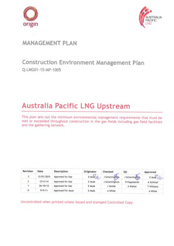
1227282133564323122VISUAL BUOYAGE GUIDEREGION B - by dayPreferred ChannelSecondary Channel3REGION-B - by nightPreferred ChannelSecondary ChannelPLATE 2
FICTITIOUS NAUTICAL CHARTIT ET G UAD STES COASATRDUN1790"1"FI (2) G 6sR "2"ING "3""2"FI R 4s"2"Iso R 6sG "7"FI G 4sAL WATERWAYT R A C O ASTG "5"FI (2) G 6sRN "2"R "8"FI R 4s"1"Iso G 4sGC "3"R "6"FI (2) R 6sR "4"Oc R 6sIso R 6sG "3"BRFI (2) 5sR "2"QRG "3"FI G 6sRGFI (2 1) R 6sRWBnG "1"Iso G 4sR "2"FI R 6sRN "2"RWMo (A)GC "3"PLATE 3
NID179 0G UA RTE D S TU.S. AIDS TO NAVIGATION SYSTEMES COASTATon the Western River SystemUAS SEEN ENTERING FROM SEAWARDPORT SIDEOR R IG HT DE S C E NDING B A NKGREEN ORWHITE LIGHTSFLASHINGISOLIGHTSTARBOARD SIDEOR L E F T DE S C E NDING B A NKPR E FE RR E D C HANNE LMARK JUNCTIONS AND OBSTRUCTIONSCOMPOSITE GROUP FLASHING (2 1)P R E F E R R E D C HA NNE LTO S TA R B OA R DTOPMOST BAND GREENP R E F E R R E D C HA NNE LTO P OR TTOPMOST BAND REDFI (2 1) GFI (2 1) RRED ORFLASHING (2)ISOLIGHTED BUOYLIGHTCANLIGHTED BUOYJGWHITE LIGHTSNUNJRMAY BELIGHTEDCNGCNRTRSGPASSING DAYBEACONDAYBOARDS HAVING NO LATERAL SIGNIFICANCECROSSING DAYBEACONMAY BE LETTEREDPASSING DAYBEACONCROSSING DAYBEACONWHITE LIGHT ONLYNBA176.9123.5MILE BOARDMILE BOARDSPECIAL MARKS--MAY BE LETTEREDNYASHAPE: OPTIONAL--BUT SELECTED TO BE APPROPRIATEFOR THE POSITION OF THE MARK IN RELA TION TO THENAVIGABLE WATERWAY AND THE DIRECTIONOF BUOYAGE.BACUNLIGHTEDMAY SHOW WHITEREFLECTOR OR LIGHTNWWHITE LIGHT ONLYSTATE WATERSINFORMATION AND REGULATORY MARKERSWHEN LIGHTED, INFORMATION AND REGULATORY MARKSMAY DISPLAY ANY LIGHT RHYTHM EXCEPT QUICK FLASHING, Mo(a)AND FLASHING (2)BOATEXCLUSIONAREADANG E RAR E ATHE NATURE OF DANGER MAYBE INDICATED INSIDE THEDIAMOND SHAPE, SUCH AS ROCK,WRECK, SHOAL, DAM, ETC.S L OWINL A ND (S TAT E ) WAT E R S OB S T R UC T ION MA R KMAY SHOW WHITEREFLECTOR OR QUICK FLASHING WHITE LIGHTWAK ETYPE OF CONTROL IS INDICATEDIN THE CIRCLE, SUCH AS SLOW,NO WAKE, ANCHORING, ETC.BLACK-STRIPEDWHITE BUOYINFORMATIONB L A C K R IV E RFOR DISPLAYING INFORMATIONSUCH AS DIRECTIONS, DISTANCES,LOCATIONS, ETC.2CONTROLLEDAREANOEXPLAINATION MAY BE PLACEDOUTSIDE THE CROSSED DIAMONDSHAPE, SUCH AS DAM, RAPIDS,SWIM AREA, ETC.3DANGERR OC KMUL L E T L A K EMOORINGBUOYWHITE WITH BLUE BANDLIGHTEDTYPICAL INFORMATION AND REGULATORY MARKSS WIMYELLOW LIGHT ONLYFIXEDFLASHINGBUOY USED TO DISPLAYREGULATORY MARKERSMAY SHOW WHITE LIGHTMAY BE LETTEREDUsed to indicate an obstruction to navigation,extends from the nearest shore to the buoy. Thismeans "do not pass between the buoy and thenearest shore." This aid is replacing the red andwhite striped buoy within the USWMS, but cannotbe used until all red and white striped buoys on awaterway have been replaced.PLATE 4
LUMINOUS RANGE DIAGRAM3sl mileutica2 naileical m1 naut54Coderds1,000 ya4s0 yard2503120.801less than 50 meters50-200 metersless than 50 yards50-200 yards234200-500 meters500-1,000 meters1-2 kilometers567892-4 kilometers4-10 kilometers10-20 kilometers20-50 kilometersgreater than 50 km200-500 yards500-1,000 yards1,000-2,000 yards1-2 nautical milesrds200 ya0.610.40.3METEORLOGICAL VISIBILITY1.2.rds50 ya(From International Visibility Code)0.203.0.1123 4 5 68 101520253035NOMINAL RANGE404.Nautical atomkil850ilesemtutsterstame13oililesk20te 64104 kilmiletute1 starsmete2 kilo8ileute m0.5 stateters1 kilom452-5.5 nautical miles5.5-11 nautical miles11-27 nautical milesgreater than 27 nmCAUTIONWhen using this diagram it must beremembered that:The ranges obtained are approximate.The transparency of the atmospheremay vary between observer and light.Glare from background lighting willreduce the range that lights are sighted.The rolling motion of a vessel and/orof a lighted aid may reduce the distancethat lights can be detected or identified.rseet63rds500 yaeters500 m321rds2200 yas0 meter200.80.61LUMINOUS RANGE statute miles6esl milticaau.5 n5(From International Visibility Code)ibilna68METEOROLOGICAL VISIBILITYvisibilvisinfiLUMINOUS RANGE Nautical miles11710(This range may be reduced by the glare of other 40infi50This diagram enables the mariner to determine the approximateluminous range of a light when the nominal range and the prevailingmeteorological visibility are known. The diagram is entered from thebottom border using the nominal range listed in column 6 of this book.The intersection of the nominal range with the appropriate visibilitycurve (or, more often, a point between two curves) yields, by movinghorizontally to the left border, the luminous range.(This range may be reduced by the glare of other lights)The nominal range given in this Light List is the maximum distance agiven light can be seen when the meteorological visibility is 10 nauticalmiles. If the existing visibility is less than 10 NM, the range at whichthe light can be seen will be reduced below its nominal range. And, ifthe visibility is greater than 10 NM, the light can be seen at greaterdistances. The distance at which a light may be expected to be seenin the prevailing visibility is called its luminous range.0.40.3METEORLOGICAL VISIBILITYrds50 ya(From International Visibility Code)ters50 me0.20123 4 5 6 810152025303540450.1NOMINAL RANGEStatute MilesGEOGRAPHIC RANGE TABLEThe following table gives the approximate geographic range of visibility for an object which may be seen by an observer at sea level. It isnecessary to add to the distance for the height of any object the distance corresponding to the height of the observer's eye above sea level.HeightFeet / MetersDistanceNautical Miles (NM)HeightFeet / 9.6140/42.7150/45.7200/61.0Example: Determine the geographic visibility of an object, with a heightabove water of 65 feet, for an observer with a height of eye of 35 feet.DistanceNautical Miles 316.5HeightFeet / MetersDistanceNautical Miles .729.831.033.135.137.0Enter above table;Height of object 65 feet 9.4 NMHeight of observer 35 feet 6.9 NMComputed geographic visibility 16.3 NM
This Page Intentionally Left Blank
TABLE OF CONTENTSLight List Regions .Inside Front CoverU.S. DGPS Sites . iUSCG Contact Information . iiPreface . vIntroduction .viSEACOASTCalifornia . 1Oregon .7Washington . 9British Columbia .10Pacific Ocean . 11Alaska. 12BAYS, RIVERS, AND HARBORSSan Diego. . 16Los Angeles and Long Beach Harbor . 26San Francisco Bay . 37Humboldt Bay. 67Coos Bay . 73Columbia River . 85Snake River. 113Grays Harbor. 136Strait of Juan de Fuca – Puget Sound . 145Strait of Georgia . 181Dixon Entrance. 187Stephens Passage . 199Prince William Sound . 221Cook Inlet . 227Alaska Peninsula . 236Hawaii. . 246Pacific Islands . 267INDEX . Index1CROSS REFERENCE.Cross Reference 1
NationwideDGPS CoverageWhidbey Island Wisconsin PointFort Stevens AppletonUpper Keweenaw Cheboygan Mequon Cape Mendocino Youngstown DetroitXXHudson FallsPenobscotAcushnetXMorichesSandy HookXXLincoln Driver KensingtonPoint Loma XAngletonXEnglish TurnTampa Cape CanaveralCard Sound KenaiXKodiakXXPotato PointGustavusXXAnnetteX IslandXBiorka Island Level IslandKokole Point Upolu Point LegendX Decomm Sites 2020Decomm Sites 2019Multiple CoverageSingle Coverage
COAST GUARD DISTRICT COMMANDERSDISTRICTADDRESSWATERS OF JURISDICTIONFIRST408 Atlantic AvenueBoston, MA 02110-3350Tel: 617-223-8356http://www.uscg.mil/d1Maine, New Hampshire, Massachusetts, Vermont(Lake Champlain), Rhode Island, Connecticut, NewYork, to Shrewsbury River, New Jersey.FIFTHFederal Building431 Crawford StreetPortsmouth, VA 23704-5004Tel: (757) 398-6486(757) 398-6552http://www.uscg.mil/d5Shrewsbury River, New Jersey to Delaware, Maryland,Virginia, District of Columbia, and North Carolina.SEVENTHBrickell Plaza Federal Building909 SE 1st Avenue; Rm:406Miami, FL 33131-3050Tel: (305) 415-6752(305) 415-6800http://www.uscg.mil/d7South Carolina, Georgia, Florida to 83 50'W, andPuerto Rico and adjacent islands of the United States.EIGHTHHale Boggs Federal Building500 Poydras StreetNew Orleans, LA 70130-3310Tel: (504) 671-2327(504) 671-2137http://www.uscg.mil/d8Florida westward from 83 50'W, Alabama, Mississippi,Louisiana, Texas, the Mississippi River System exceptthat portion of the Illinois River north of Joliet, Illinois.NINTH1240 East 9th StreetCleveland, OH 44199-2060Tel: (216) 902-6060(216) 902-6117http://www.uscg.mil/d9Great Lakes and St. Lawrence River above St. RegisRiver.ELEVENTHCoast Guard Island Building 50-2Alameda, CA 94501-5100Tel: (510) 437-2975http://www.uscg.mil/d11THIRTEENTHFederal Building915 Second Avenue 35th Floor, Rm 3510Seattle, WA 98174-1067Tel: (206) 220-7270(206) 220-7004http://www.uscg.mil/d13FOURTEENTHPrince Kalanianaole Federal Bldg.300 Ala Moana Blvd9th Floor, Room 9-220Honolulu, HI 96850-4982Tel: (808) 535-3409(808) 535-3414http://www.uscg.mil/d14Hawaiian, American Samoa, Marshall, Marianas, andCaroline Islands.SEVENTEENTHPO Box 25517Juneau, AK 99802-5517Tel: (907) 463-2029(907) 463-2269http://www.uscg.mil/d17Alaska.California, Nevada, Utah, Arizona.iiOregon, Washington, Idaho, and Montana.
U. S. COAST GUARDELEVENTH DISTRICT UNIT LISTINGAIDS TO NAVIGATION TEAMSANT Humboldt Bay200 New Navy Base Rd Bldg 8Samoa, CA 95564-9999Tel: (707) 269-2550ANT Los Angeles/Long Beach1001 South Seaside AvenueBldg 22San Pedro, CA 90731Tel: (310) 521-3890ANT San Diego2710 Harbor Drive NorthSan Diego, CA 92101-1079Tel: (619) 683-6358ANT San FranciscoYerba Buena IslandSan Francisco, CA 94130-5013Tel: (415) 399-3515BUOY TENDERSUSCGC GEORGE COBB (WLM 564)1001 South Seaside AvenueSan Pedro, CA 90731Tel: (310) 521-4580USCGC ASPEN (WLB 208)c/o Coast Guard BaseYerba Buena IslandSan Francisco, CA 94130-5013Tel:(415) 399-3590/91/92U. S. COAST GUARDTHIRTEENTH DISTRICT UNIT LISTINGAIDS TO NAVIGATION TEAMSANT COOS BAYPO Box 5650Charleston, OR 97420-0627Tel: (541) 888-3441ANT ASTORIATongue Point FacilityAstoria, OR 97103-2099Tel: (503) 325-3301ANT KENNEWICK434 Clover IslandKennewick, WA 99336-3784Tel: (509) 586-1110ANT PUGET SOUND1519 Alaskan Way SouthSeattle, WA 98134-1192Tel: (206) 217-6918BUOY TENDERSUSCGC ELM (WLB-204)c/o CG Base Tongue PointAstoria, OR 97103-7200Tel: (503) 325-1601USCGC BLUEBELL (WLI-313)6767 North Basin AvenuePortland, OR 97217-3992Tel: (503) 240-9362USCGC HENRY BLAKE(WLM-563)Naval Station Everett2000 West Marine View DriveEverett, WA 98207Tel: (425) 304-5740U. S. COAST GUARDFOURTEENTH DISTRICT UNIT LISTINGAIDS TO NAVIGATION TEAMANT Honolulu400 Sand Island Access RoadHonolulu,HI 96819-4398Tel: (808) 842-2851BUOY TENDERSUSCGC SEQUOIA(WLB 215)FPO AP 96678-3922Tel: (671) 355-4885USCGC WALNUT (WLB 205)400 Sand Island Access RoadHonolulu, HI 96819-4398Tel: (808) 842-2865iii
U. S. COAST GUARDSEVENTEENTH DISTRICT UNIT LISTINGAIDS TO NAVIGATION TEAMSANT KODIAKP.O. BOX 195098Kodiak, AK 99619-5098Tel: (907) 487-5181ANT SITKA613 Airport RoadSitka, AK 99835Tel: (907) 966-5410BUOY TENDERSUSCGC ANTHONY PETIT (WLM 558)1340 Stedman StreetKetchikan, AK 99901Tel: (907) 228-0356USCGCELDERBERRY (WLI 65401)PO Box 550Petersburg, AK 99833-0550Tel: (907) 772-4225USCGC HICKORY (WLB 212)4688 Homer Spit Rd.Homer, AK 99603-8001Tel: (907) 235-5233USCGC KUKUI (WLB 203)1480 Seward AvenueSitka, AK 99835-9454Tel: (907) 966-5470USCGC SPAR (WLB 206)PO Box 190651c/o CG ISCKodiak, AK 99169-0651Tel: (907) 487-5344USCGC SYCAMORE (WLB 209)PO Box 300Cordova, AK 99574Tel: (907) 424-3434iv
USCG NAVIGATION CENTERNavigation Information Service (NIS)The U.S. Coast Guard Navigation Center (NAVCEN) is the official government source of information for civil users of theGlobal Positioning System (GPS). The Navigation Information Service (NIS) is available 24 hours a day, seven days a week,for all Radio Navigation and maritime related needs via phone, fax or e-mail. The NIS provides users the ability to accessreal time or archived GPS, NDGPS, DGPS, and LNM information at https://www.navcen.uscg.gov, as well as subscribe toan automated list service which enables users to receive GPS status messages and Notice to NAVSTAR User (NANU)messages via direct Internet e-mail.The NAVCEN also disseminates GPS and DGPS safety advisory broadcast messages through USCG broadcast stations utilizing VHF-FM voice, HF-SSB voice, and NAVTEX broadcasts. The broadcasts provide the GPS and DGPS user in the marineenvironment with the current status of the navigation systems, as well as any planned/unplanned system outages that couldaffect GPS and DGPS navigational accuracy.To comment on any of these services or ask questions about the service offered, contact the NAVCEN at:Commanding OfficerU.S. Coast Guard NAVCEN (NIS) MS73107323 Telegraph RoadAlexandria, VA 20598-7310 Phone:(703) 313-5900FAX: (703) 313-5920Internet: https://www.navcen.uscg.govThis Light List is corrected through:Eleventh Coast Guard District Local Notice to Mariners No. 01/19Thirteenth Coast Guard District Local Notice to Mariners No. 01/19Fourteenth Coast Guard District Local Notice to Mariners No. 01/19Seventeenth Coast Guard District Local Notice to Mariners No. 01/19 and throughNational Geospatial-Intelligence Agency (NGA) Notice to Mariners No.01/19The 2019 edition supersedes the 2018 edition.RECORD OF CORRECTIONSYEAR 2019YEAR .47.48.49.50.46.47.48.49.50.51.52.51.52.v2.3.4.5.
PREFACELights and other marine aids to navigation, maintained by or under authority of the U.S. Coast Guard and located on watersused by general navigation, are described in the Light List. This volume includes aids located on the PacificCoast, Pacific Islands, and the Coast of Alaska.Included are all Coast Guard aids to navigation used for general navigation such as lights, sound signals, buoys, daybeacons,and other aids to navigation. Not included are some buoys having no lateral significance, such as special purpose, anchorage,fish net, and dredging.Aids to Navigation Link: http://www.uscgboating.org/ATON/index.htmlCAUTION: Mariners attempting to pass a buoy close aboard risk collision with a yawing buoy or with the obstruction, which thebuoy marks. Mariners must not rely on buoys alone for determining their positions due to factors limiting buoy reliability.PRIVATE AIDS TO NAVIGATIONIncluded: Class I aids to navigation on marine structures or other works which the owners are legally obligated to establish,maintain, and operate as prescribed by the Coast Guard.Included: Class II aids to navigation exclusive of Class I, located in waters used by general navigation.Not included: Class III aids to navigation exclusive of Class I and Class II, located in waters not ordinarily used by general navigation.LIGHT LIST AVAILABLITYThis Light List is published electronically annually and is intended to furnish more complete information concerning aids to navigation than can be conveniently shown on charts. This Light List is not intended to be used in place of charts or Coast Pilots.Charts should be consulted for the location of all aids to navigation. It may be dangerous to use aids to navigation without reference to charts.This list is corrected to the date of the notices to mariners shown on the title page. Changes to aids to navigation during theyear are advertised in U.S. Coast Guard Local Notices to Mariners and National Geospatial-Intelligence Agency (NGA) Noticesto Mariners. Important changes to aids to navigation are also broadcast through Coast Guard or Naval radio stations andNAVTEX. Mariners should keep their Light Lists, charts and other nautical publications corrected from these notices and shouldconsult all notices issued after the date of publication of this Light List.The electronic version of this publication is available at: https://www.navcen.uscg.gov/index.php?pageName lightListsA weekly-updated electronic copy of this publication is also available at:https://www.navcen.uscg.gov/index.php?pageName lightListWeeklyUpdatesReporting Aids to Navigation Discrepanies: https://www.navcen.uscg.gov/?pageName atonOutageReportIMPORTANT: A summary of corrections for this publication, which includes corrections from the dates shown on the titlepage to the date of availability, is advertised in the Local Notice to Mariners and the Notice to Mariners. These correctionsmust be applied in order to bring the Light List up-to-date. Additionally, this publication should be corrected weekly from theLocal No-tices to Mariners or the Notices to Mariners, as appropriate.Mariners and others are requested to bring any apparent errors or omissions in these lists to the attention of:Commander (dpw)Eleventh Coast Guard DistrictBuilding 50-2Coast Guard IslandAlameda, CA 94501-5100Commander (dpw)Thirteenth Coast Guard District915 2nd Avenue 35th Floor, Rm 3510Seattle, WA 98174-1067Commander (dpw)Fourteenth Coast Guard District300 Ala Moana Blvd.Room 9-220Honolulu, Hi 96850-4982Commander (dpw)Seventeenth Coast Guard DistrictPO Box 25517Juneau, AK 99802-5517viorUSCG Navigation CenterCharting BranchMS 73107323 Telegraph RoadAlexandria, VA 20598-7310Email: TIS-PF-NISWS@USCG.MIL
INTRODUCTIONLight List ArrangementIn the context of the Light List, aids to navigation on the coasts are arranged in geographic orderclockwise from north to south along to Atlantic coast, east to west along the Gulf of Mexico, andsouth to north along the Pacific coast. On the Great Lakes, aids to navigation are arranged fromeast to west and from south to north, except on Lake Michigan, which is arranged from northto south. Seacoast aids to navigation are listed first, followed by entrance and harbor aids tonavigation, arranged from seaward to the head of navigation.Names of aids to navigation are printed as follows to help distinguish at a glance the type of aidto navigation.Seacoast/Lake coast Lights and Secondary LightsRACONSSound SignalsRIVER, HARBOR, OTHER LIGHTS, AND VIRTUAL AISLighted BuoysDaybeacons, Unlighted Buoys, and Virtual Automatic Identification System (V-AIS) ATONLight List numbers are assigned to all Federal aids to navigation and many private aids tonavigation for reference in the Light List. Aids to navigation are numbered by fives inaccordance with their order of appearance in each volume of the Light List. Other numbers anddecimal fractions are assigned where newly established aids to navigation are listed betweenpreviously numbered aids to navigation. The Light Lists are renumbered periodically to assignwhole numbers to all aids to navigation.International numbers are assigned to certain aids to navigation in cooperation with theInternational Hydrographic Organization. They consist of an alphabetic character followed bythree or four numeric characters. A cross reference listing appears after the index.Description of ColumnsColumn (1): Light List Number.Column (2): Name and location of the aid to navigation.Note: A dash (-) is used to indicate the bold heading is part of the name of the aidto navigation. When reporting discrepancies or making references to such an aidto navigation in correspondence, the full name of the aid including the geographicheading, should be given.Bearings are in degrees true, read clockwise from 000 through 359 .Bearings on range lines are given in degrees and tenths or hundredths whereapplicable.(C) indicates Canadian aid to navigation.Column (3): Geographic position of the aid to navigation in latitude and longitude.Column (4): Light characteristic for lighted aids to navigation.vii
Column (5): Height above water from the focal plane of the fixed light to mean high water, listedin feet.For Volume 6 (Pacific Coast and Pacific Islands), for the Columbia and SnakeRivers height above water from the focal plane of the fixed to the applicable riverdatum, listed in feet.Column (6): Nominal range of lighted aids to navigation, in nautical miles, listed by color forsector and passing lights. Not listed for ranges, directional lights, or private aids tonavigation.Column (7): The structural characteristic of the aid to navigation, including: dayboard (if any),description of fixed structure, color and type of buoy, height of structure aboveground for major lights.Column (8): Aid remarks, sound signal characteristics, including: VHF-FM channel if remotelyactivated, RACON characteristic, light sector arc of visibility,
the light can be seen will be reduced below its nominal range. And, if the visibility is greater than 10 NM, the light can be seen at greater . bottom border using the nominal range listed in column 6 of this book. The intersection of the nominal range with the appropriate visibility curv
