Transcription
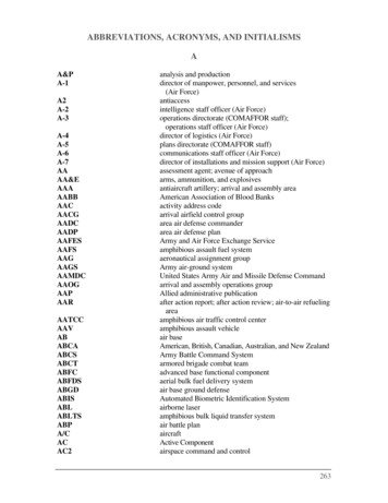
ACRONYMS AND ABBREVIATIONSAGL - Above Ground LevelAP - Anomalous PropagationARL -Above Radar LevelAVSET - Automated Volume Scan Evaluation and TerminationAWIPS - Advanced Weather Interactive Processing SystemBE – Book End as in Book End VortexBWER - Bounded Weak Echo RegionCAPE - Conditional Available Potential EnergyCIN – Convective InhibitionCC – Correlation Coefficient Dual Pol ProductCR -Composite Reflectivity ProductCWA -County Warning AreaDP – Dual PoldBZ - Radar Reflectivity FactorDCAPE - Downdraft Conditional Available Potential EnergyDCZ - Deep Convergence ZoneEL – Equilibrium LevelET -Echo Tops ProductETC - Extratropical CycloneFAR - False Alarm RatioFFD – Forward Flank DowndraftFFG – Flash Flood GuidanceGTG – Gate-To-GateHP - High Precipitation supercell (storm)HDA -Hail Detection AlgorithmLCL -Lifting Condensation LevelLEWP -Line Echo Wave PatternLP - Low Precipitation Supercell (storm)MARC - Mid Altitude Radial ConvergenceMCC - Mesoscale Convective ComplexMCS - Mesoscale Convective SystemMCV – Mesoscale Convective VortexMESO -MesocycloneMEHS -Maximum Expected Hail SizeOHP -One-Hour Rainfall Accumulation ProductPOSH -Probability of Severe HailQLCS - Quasi Linear Convective SystemsR - Rainfall Rate in Z-R relationshipRF – Range FoldingRFD - Rear Flank Downdraft
RIJ - Rear Inflow JetRIN – Rear Inflow NotchSAILS - Supplemental Adaptive Intra-Volume Low-Level ScanSCP – Supercell Composite ParameterSRH – Storm Relative HelicitySRM -Storm Relative Mean Radial VelocitySTP –Significant Tornado ParameterSTD – Storm Top DivergenceTBSS -Three-Body Scatter SpikeTDA -Tornado Detection AlgorithmTDS – Tornado Debris SignatureTDWR -Terminal Doppler Weather RadarTHP -Three-Hour Rainfall Accumulation ProductTVS - Tornadic Vortex Signature (in velocity data) and in the WSR -88D ProductV – Radial Velocity dataVCP - Volume Coverage PatternVIL - Vertically Integrated Liquid ProductVWP - Velocity Azimuth Display Wind Profile ProductVR – Rotational VelocityW - Spectrum Width DataWER - Weak Echo RegionWSR-88D - Weather Surveillance Radar - 1988 DopplerZ - Radar Reflectivity DataZDR – Differential Reflectivity Dual Pol ProductZR – Reflectivity/Rainfall Rate RelationshipGLOSSARYAnomalous Propagation (AP): When non-standard index-of-refraction distributions prevail, “abnormal”or “anomalous” propagation occurs. When abnormal downward bending occurs, it is called“superrefraction.” The term “subrefraction” is applied when there is abnormal upward bending.Attenuation: Any process in which the flux density (power) of a beam of energy is dissipated.Automated Volume Scan Evaluation and Termination (AVSET): An algorithm that terminates a radarvolume scan after the WSR-88D has scanned all of the elevations with significant reflectivity returns.Base Data: Reflectivity, mean radial velocity, and spectrum width data.Book-End Vortices: (Also called “line-end vortices.”) With time, MCSs tend to develop vortex pairs withopposite sense rotation at the ends of the convective line.
Bounded Weak Echo Region (BWER): A core of weak reflectivity in a thunderstorm that identifies thelocation of an intense updraft. The updraft is so strong that large precipitation particles do not havetime to form in the lower and mid-levels of the storm and are prevented from falling back into theupdraft core from above.Bow Echo: A bow-shaped line of convective cells that is often associated with swaths of damagingstraight-line winds and short-lived tornadoes. Key structural features include an intense rear inflow jetimpinging on the core of the bow, with bookend or line-end vortices on both sides of the rear-inflow jet,behind the ends of the bowed convective segment.Bright Band: The enhanced radar echo caused by the difference in radar reflectivity of ice and waterparticles. This echo is interpreted as the delineation on a radar display between frozen and liquidprecipitation.Cap: (as in capping inversion) A layer of relatively warm air aloft (usually several thousand feet abovethe ground) which suppresses or delays the development of thunderstorms.Centroid: The center of mass of a storm.Clutter: Echoes that interfere with observations of desired signals on a radar display. Usually applied toground targets.Comma Head: (Sometimes known as “rotating comma head.”) The northern, rounded portion of aconvective line of storms called a bow echo and often associated with a mesocyclone or mesovortex.Convective Available Potential Energy (CAPE): A measure of instability. The maximum energy availableto an ascending parcel, according to parcel theory. On a thermodynamic diagram this is called positivearea, and can be seen as the region between the lifted parcel process curve and the environmentalsounding, from the parcel's level of free convection to its level of neutral buoyancy.Convective Inhibition (CIN): A measure of the amount of energy needed in order to initiate convectionreflecting the strength of the cap.Couplet: Adjacent maxima of radial velocities of opposite signs.Cyclic: As in cyclic storm; a thunderstorm that undergoes cycles of intensification and weakening(pulses) while maintaining its individuality. Cyclic supercells are capable of producing multiple tornadoes(i.e., a tornado family) and/or several bursts of severe weather.Dealiasing: Process of correcting for aliases in the velocity measurement.Debris Ball: An area of high radar reflectivity, typically located within a hook or appendage, caused bylarge debris being lofted into the air and usually associated with a tornado or tornado vortex signature.
Deep Convergence Zone (DCZ): A narrow and deep velocity signature characterized by strongconvergence along a nearly vertical interface extending from the radar horizon upward to altitudes ashigh as 50,000 ft. often associated with very damaging surface winds and related to the Mid AltitudeRadial Convergence.Delta-V: The quantity of maximum inbound and outbound radial velocity (Vin Vout); a measure of thestrength of convergence, divergence, or rotation.Derecho: A widespread convectively induced straight-line windstorm event. Specifically, the term isdefined as any family of downburst event clusters produced by an extratropical mesoscale convectivesystem. Derechos may or may not be accompanied by tornadoes.Downburst: A strong downdraft that induces an outburst of damaging winds on or near the ground.Downdraft: Current(s) of air with marked vertical downward motion.Downdraft Convective Available Potential Energy (DCAPE): Downdraft CAPE. DCAPE can be used toestimate the potential strength of rain-cooled downdrafts with thunderstorms, and is similar to CAPE.Larger DCAPE values are associated with stronger downdrafts.Dual-Polarization Radar: A radar capable of transmitting and receiving two orthogonal polarizations.Dual Polarization Variables: The three radar variables (Differential Reflectivity, Correlation Coefficient,and Differential Phase) derived by comparing the attributes of the returned Horizontal and Verticalpulses.Ducting: The phenomenon by which the radar signal propagates along the boundary of two dissimilar airmasses. Ducting occurs when the upper air is exceptionally warm and dry in comparison with the air atthe surface.Echoes: Areas of radar reflectivity visible in the WSR-88D products that may represent meteorological ornon-meteorological phenomena.Echo Tops: The height of the greatest (in altitude) non-zero reflectivity above the surface of the Earth.Echo Training: Thunderstorm (or shower) cells following one after another over the same location.Elevation Angle: The angle of the radar beam. This value varies from 0.5º to 19.5º on the WSR-88D.Elevation Scan: The process of the radar completing a full 360 rotation in azimuth for a specificelevation angle.
Equilibrium Level (EL): The level above the level of free convection (LFC) at which the temperature of arising air parcel again equals the temperature of the environment.Forward Flank Downdraft (FFD): The main region of downdraft in the forward, or leading, part of asupercell, where most of the heavy precipitation (rain, hail) is located.Gate-to-Gate (GTG): A term used to describe when the maximum inbound and maximum outboundradar velocity is immediately adjacent to each other (side by side).Ground Clutter: The pattern of radar echoes from fixed ground targets.Gust Front: The boundary or leading edge of the downdraft (propagating cold air outflow) from athunderstorm.Helicity: One-half the scalar product of the velocity and vorticity vectors. The concept is useful inunderstanding severe convective storms and tornadoes, since in strong updrafts the velocity andvorticity vectors tend to be aligned, yielding high helicity.Hook Echo: A pendant or hook on the right side of a radar reflectivity echo that often identifiesmesocyclones on the radar display. The hook is caused by precipitation drawn into a cyclonic spiral bythe winds, and the associated notch in the echo is caused by precipitation-free, warm, moist air flowinginto the storm.Isodop: Contour of constant Doppler velocity values.Isolated Storm: An individual cell or group of cells that are identifiable and separate from other cells in agiven geographic area.Lapse Rate: The decrease of an atmospheric variable with height, the variable being temperature, unlessotherwise specified.Lifting Condensation Level (LCL): The level at which a parcel of moist air lifted dry-adiabatically wouldbecome saturated.Line Echo Wave Pattern (LEWP): A special configuration in a line of convective storms configured like awave which may indicate the presence of a low pressure area and the possibility of damaging winds andtornadoes. In response to very strong outflow winds behind it, a portion of the line may bulge outwardforming a bow echo.Low-topped Supercells: A convective storm that contains similar radar characteristics to those of asupercell (e.g., mesocyclone, hook echo, WER, BWER), but is significantly smaller in height.
Macroburst: Large downburst with 4 km (2.2 nmi) or larger outflow size with damaging wind lasting 5 to20 minutes.Maximum Expected Hail Size (MEHS): A radar algorithm that computes the maximum expected hailsize. MESH usually overestimates the maximum size of hail that will reach the earth's surface. MESH isdesigned such that approximately 75% of hail will be smaller than the MESH.Mean Doppler Velocity: Reflectivity-weighted average velocity of targets in a given volume sample. Alsocalled mean radial velocityMesocyclone or Mesovortex (meso): A 3-dimensional storm scale region of cyclonic rotation in a stormand is closely correlated with severe weather.Mesoscale: Pertaining to atmospheric phenomena having horizontal scales ranging from a few toseveral hundred kilometers, including thunderstorms, squall lines, fronts, precipitation bands.Mesoscale Convective Complex (MCC): A subset of mesoscale convective systems (MCS) that exhibit alarge, circular (as observed by satellite), long-lived, cold cloud shield having a cloud-top area larger than100,000 km2 (29,000 n mi2) and persisting for more than 6 hours.Mesoscale Convective System (MCS): A cloud system that occurs in connection with an ensemble ofthunderstorms and produces a contiguous precipitation area on the order of 100 km or more inhorizontal scale in at least one direction.Mesoscale Convective Vortex (MCV): A warm core mid-altitude mesoscale vortex often produced as anMCC or MCS decays; often associated with a recurrence of convection.Mean Radial Velocity: The component of motion of the target toward or away from the radar.Microburst: Small downburst, 1 to 4 km (0.54 to 2.2 nmi) in outflow size, with peak winds lasting 2 to 15minutes.Mid-Altitude Radial Convergence Signature (MARC): Persistent areas of radial convergence within midlevels ( 3 to 7 km AGL)and within the larger zone of convergence along the forward flank of theconvective line or storm and appears to be linked to the greatest degree of wind damage. Similar to theDeep Convergence Zone but generally confined to the mid-levels.Mini-Supercell: A convective storm that contains similar radar characteristics to those of a supercell(e.g., mesocyclone, hook echo, WER, BWER), but is significantly smaller in height and width.Overhang: A storm has overhang if the edge of the storm component at a given height range (midlevels) extends outward beyond the edge of the storm component at the lowest elevation by a specifieddistance.
Probability of Severe Hail (POSH): A radar algorithm that computes the probability that a cell willproduce severe size hail.Pulse: A single short duration transmission of electromagnetic energy.Pulse Severe Storm: A convective storm characterized by a single, strong, updraft pulse producing ashort-lived period of large hail or damaging winds at the surface; lifespan typically 60 minutes.Quasi-linear Convective System (QLCS): A linear configuration of organized thunderstorms such as asquall line or bow echo.Radial Velocity: The component of motion of the target toward or away from the radar.Radome: A dome used to cover the antenna assembly of a radar to protect it from the effects ofweather.Range Folding (RF): Range Folding is basically when the radar is unable to determine the wind's velocity.This is due to the speed at which the radar transmits signals, called the pulse repetition frequency (PRF).The faster the pulses are sent by the radar the less time it has to listen for any returned signals. It occurswhen the return from a prior pulse is detected during the listening period for the current pulse. Bothreflectivity and velocity data are affected by this. The occurrence of range folding can usually bedetected by radar software and reflectivity data can be "unfolded" using special programs. However,velocity data cannot be accurately unfolded and therefore the effective range with which Doppler radarscan detect velocity data is limited by the frequency of the radar pulses; the higher the pulse rate, theshorter the range within which the velocity field can be determined.Rear Flank Downdraft (RFD): A downdraft almost exclusively associated with supercell storms foundalong the rear portion (facing in the direction of storm motion) of the storm and associated with themesocyclone and often, tornadoes. Sometimes responsible for damaging surface winds.Rear Inflow Jet (RIJ): A mesoscale circulation feature in which a system-relative current of air enters andflows through the stratiform precipitation region of an MCS from the rear. The rear inflow jet forms inresponse to the upshear-tilting of the convective circulation, as the horizontal buoyancy gradients alongthe back edge of the system create a circulation that draws mid-level air in from the rear. The rearinflow jet supplies potentially cold and dry mid-level air that aids in the production of convective andsystem-scale downdrafts.Rear Inflow Notch (RIN): A channel of weak echo extending from the rear into a convective storm line.Often associated with the rear inflow jet.
Reflectivity: The measure of the efficiency of a target in intercepting and returning electromagneticradar energy. With hydrometeors, it is a function of the drop size distribution, number of particles.Refraction: Changes in the direction of energy propagation (due to changes in speed) as a result ofdensity changes within the propagating medium.Rotational Velocity (Vr): A quantity used to evaluate the strength of rotation depicted in doppler radarvelocity data; Vr (Vmax Vmin )/2 where Vmax is the maximum outbound velocity ( ) and Vmin is themaximum inbound velocity (-).Scatterer: Any object capable of reflecting the radar signal.Shear: The rate of change of the vector wind in a specified direction normal to the wind direction.Vertical shear is the variation of the horizontal wind in the vertical direction.Shelf Cloud: A type of arcus (or roll) cloud. It is a low-level horizontal accessory cloud that appears to bea wedge shape as it approaches as seen along the leading edge of approaching thunderstorms. It isaccompanied by gusty straight-line winds and is followed by precipitation.Significant Tornado Parameter (STP): A multiple ingredient, composite index that includes effective bulkwind difference (EBWD), effective storm-relative helicity (ESRH), 100 mb mean parcel CAPE (mlCAPE),100 mb mean parcel LCL height (mlLCL), and 100 mb mean parcel CIN (mlCIN). A majority of significanttornadoes (EF2/F2 or greater damage) have been associated with STP values greater than 1.Spearhead Echo: A radar echo associated with a downburst with a pointed appendage extending towardthe direction of the echo motion. The appendage moves much faster than the parent echo, which isdrawn into the appendage. During the mature stage, the appendage turns into a major echo and theparent echo loses its identity.Spectrum Width: A measure of dispersion of velocities within the radar sample volume.Squall Line: A line of active thunderstorms, either continuous or with breaks, including contiguousprecipitation areas resulting from the existence of the thunderstorms. The squall line is a type ofmesoscale convective system distinguished from other types by a larger length-to-width ratio.Storm Relative Helicity (SRH): A measure of the potential for cyclonic updraft rotation in right-movingsupercells. Larger values of 0-3 km SRH ( 250 m2s-2) and 0-1 km SRH ( 100 m2s-2) suggest an increasedthreat of tornadoes with supercells and also QLCSs.Storm Top Divergence (STD): A measure of the divergence at the top of a thunderstorm, used toquantify updraft strength.
Stratiform: Descriptive of clouds or precipitation of extensive horizontal development, as contrasted tothe vertically developed convective clouds or precipitation types.Supercell: An often dangerous convective storm that contains radar characteristics such as the hookecho, WER, and BWER but also contains a deep, persistent mesocyclone characterized most often bycyclonic vorticity and closely associated with the dominant storm updraft and RFD. Variations includethe “Low Precipitation” (LP), Classic, and “High Precipitation” (HP) Supercells.Supercell Composite Parameter (SCP): A multiple ingredient, composite index that includes effectivestorm-relative helicity (ESRH, based on Bunkers right supercell motion), most unstable parcel CAPE(muCAPE), and effective bulk wind difference (EBWD). Each ingredient is normalized to supercell"threshold" values, and larger values of SCP denote greater "overlap" in the three supercell ingredients.Only positive values of SCP are displayed, which correspond to environments favoring right-moving(cyclonic) supercells.Supplemental Adaptive Intra-Volume Low-Level Scan (SAILS): A dynamic scanning technique thatinserts a new low-level split cut scan into severe weather VCPs 12 and 212. The effect of this scanningtechnique is to decrease the time interval between lowest angle split cut scans by half.Three-body Scatter Spike (TBSS): (Also called a “flare echo.”) A long, narrow, weak reflectivity echoartifact sometimes found extending down radial from highly reflective echo cores. Indicative of large hailand caused by forward Mie scattering or radar signals, reflecting from the hail core, to the ground, backto the hail core, and back to the radar.Tilt: A storm is said to have tilt if a line connecting the centroid of a mid-level storm component to thecentroid of the lowest storm component is to the right or rear of the direction of movement of thestorm.Tornado Debris Signature (TDS): Sometimes also referred to as Dual Pol TDS (DPTDS), the co-location oflow correlation coefficient (CC) values 0.8; low differential reflectivity (ZDR) values 0.5 dB; highreflectivity values 45 dBz, and a strong doppler velocity couplet in dual polarization radar data.Tornado Vortex Signature (TVS): The Doppler velocity signature of a vortex that is indicative of atornado or tornadic circulation, which is a gate-to-gate velocity couplet within a mesovortex observed atclose range, generally within 54nm.VAD Wind Profiler (VWP): A time-height display of horizontal winds above a doppler radar, derivedfrom WSR-88D data. It depicts the change in wind with time at various heights. This display is useful forobserving local changes in vertical wind shear, such as backing of low-level winds, increases in speedshear, and development or evolution of nearby jet streams (including low-level jets).Velocity Aliasing: Ambiguous detection of radial velocities outside the Nyquist co-interval.
Vertically Integrated Liquid (VIL): A parameter that takes into account the three dimensional reflectivityof an echo. The maximum VIL of a storm is useful in determining its potential severity, especially interms of maximum hail size.Volume Coverage Pattern: The automatic radar scanning sequence control as it scans the atmosphericvolume (from the surface to 70,000 ft and from the radar to 248 nm radius) surrounding the radar.Vortex: A region of rotation similar to a mesocyclone that possesses vorticity.Vorticity: A vector measure of local rotation in a fluid flow.Wall Cloud: A local, abrupt lowering of a rain-free cumulonimbus base into a low-hanging accessorycloud and typically signifies the base of the thunderstorm updraft. The wall cloud is usually located inthe southwestern part of a severe thunderstorm to the southwest of the main precipitation region.Rapid upward motion and visible rotation may be seen in wall clouds from several km away.Weak Echo Region (WER): A region of weak radar echo that is bounded on one side and above bystrong echo. It is located on the low-altitude inflow side of the storm and is produced by a strongupdraft.Wind Shear: The local variation of the wind in a given direction (horizontal and vertical).
ACRONYMS AND ABBREVIATIONS AGL - Above Ground Level AP - Anomalous Propagation . Base Data: Reflectivity, mean radial velocity, and spectrum width data. Book-End Vortices: (Also called "line-end vortices.") With time, MCSs tend to develop vortex pairs with . The center of mass of a storm. Clutter: .
