Transcription
resourcesReviewBiomass Resources of Phragmites australisin Kazakhstan: Historical Developments,Utilization, and ProspectsAzim Baibagyssov 1,2,3, *, Niels Thevs 2,4 , Sabir Nurtazin 1 , Rainer Waldhardt 3 ,Volker Beckmann 2 and Ruslan Salmurzauly 11234*Faculty of Biology and Biotechnology, Al-Farabi Kazakh National University, Almaty 050010, Kazakhstan;nurtazin.sabir@gmail.com (S.N.); ruslaan.200587@gmail.com (R.S.)Faculty of Law and Economics & Institute of Botany and Landscape Ecology, University of Greifswald,17489 Greifswald, Germany; n.thevs@cgiar.org (N.T.); volker.beckmann@uni-greifswald.de (V.B.)Division of Landscape Ecology and Landscape Planning, Institute of Landscape Ecology andResources Management, Center for International Development and Environmental Research (ZEU),Justus Liebig University Giessen, 35390 Giessen, Germany; rainer.waldhardt@umwelt.uni-giessen.deCentral Asia Office, World Agroforestry Center, Bishkek 720001, KyrgyzstanCorrespondence: azim.baibagyssov@agrar.uni-giessen.de or azim.baibagysov@gmail.comReceived: 5 April 2020; Accepted: 12 June 2020; Published: 16 June 2020 Abstract: Common reed (Phragmites australis (Cav.) Trin. Ex Steud.) is a highly productive wetlandplant and a potentially valuable source of renewable biomass worldwide. There is more than10 million ha of reed area globally, distributed mainly across Eurasia followed by America and Africa.The literature analysis in this paper revealed that Kazakhstan alone harbored ca. 1,600,000–3,000,000 haof reed area, mostly distributed in the deltas and along the rivers of the country. Herein, we exploredthe total reed biomass stock of 17 million t year 1 which is potentially available for harvestingin the context of wise use of wetlands. The aim of this paper is to reveal the distribution of reedresource potential in wetland areas of 13 provinces of Kazakhstan and the prospects for its sustainableutilization. Reed can be used as feedstock as an energy source for the production of pellets andbiofuels, as lignocellulosic biomass for the production of high strength fibers for novel constructionand packaging materials, and innovative polymers for lightweight engineering plastics and adhesivecoatings. Thereby, it is unlikely that reed competes for land that otherwise is used for food production.Keywords: reed beds; wetlands; bioeconomy; feedstock; Central Asia; utilization; SovietSocialist Republics1. IntroductionOil, gas, and coal deposits are limited fossil resources, and their combustion contributes to climatechange by releasing large amounts of carbon dioxide into the atmosphere. Finiteness of those resourcesand necessity to reduce the CO2 burden of the atmosphere significantly increase the importance ofbiomass as a resource for energy production or as a chemical feedstock for innovative utilizationpathways within knowledge-based production [1,2]. This shift is often called bioeconomy, and itsgrowth augments the use of biomass as a primary renewable feedstock for material and energyuse [3–5]. Increasing the supply of biomass, however, often results in competition with food and feedproduction, and leads, in the short or long term, to food-feed-fuel conflicts, for example, in the case ofincreased utilization of corn or other food crops as feedstock for biogas or biofuels [6–8]. To minimizethese aforesaid food-feed-fuel conflicts, sites unsuitable for regular farming can be utilized for biomassproduction. Significant potential against this background is seen in the conservation and wise use ofResources 2020, 9, 74; esources
Resources 2020, 9, 742 of 25wetlands and reed bed areas [9–11]. While their sustainable management for benefits of the exploitationof reed has become increasingly attractive from the economic perspective [12,13], the growing demandfor sustainable biomass portrays wetlands and reed bed areas as increasingly interesting for a circularbioeconomy. In this context, widespread wetland plant common reed (Phragmites australis) has becomean increasingly attractive source of renewable biomass from its monotonous reed beds. Next to theirhigh productivity, they also provide a broad range of ecosystem services (e.g., resources provision,recreation, flood mitigation, and aesthetics) and a habitat of wildlife [14–17].Globally, there are more than 10 million ha of reed bed area, as calculated by [18] and summarizedin a review study [19], mostly spread across Eurasia followed by America [20]. About half of the totalarea exists in the former Soviet Union [21–23], shared mainly by Kazakhstan and other Central Asiancountries [24,25].For a couple of decades, reed beds have been neglected in the research, regardless of this fact,Kazakhstan harbors about two million ha and, more importantly, it is the country with one of the mostsubstantial reed bed areas worldwide according to [26] cited in [27]. While the spatial distribution andassessed area of wetlands and reed biomass resources have been previously demonstrated for the IliDelta in southeast Kazakhstan [28], to date, a limited attempt has been made to conduct any assessmentacross the country. Against this background, this study focused on the type of information that isavailable about the number of reed resources, its development, and spatial distribution. The purposeof this study was to determine the resource potential and biomass perspectives of common reed(Phragmites australis) in Kazakhstan. The research looks at the driving forces of past, current, and futuredevelopments of reed resources and how they influence the utilization of reed resources.The study was motivated by three main questions as follows: What is the current development and state of reed resources in Kazakhstan?What are the driving forces of wetlands and reed bed areas change in Kazakhstan?What past, current, and future utilization of reed resources are documented and possiblein the future?In addressing these research questions, detailed data on reed bed areas and visual illustrationof their spatial distribution in the 13 provinces of the country are provided. Moreover, the driversaffecting the development of wetland areas across Kazakhstan and a showcase of the largest in CentralAsia, the Ili Delta, as a wetland complex lying downstream in a transboundary river basin is providedwith retrospective analyses in the changes of wetlands and reed bed areas in the course of the last50 years. The research was conducted using the narrative literature review method based on theinternational and, in particular, the Russian and Kazakh literature. The authors used archive materialsand reports available for the period of study, publications, dissertations, several internationally fundedproject reports, and their findings from investigations on the experience of projects fulfilled in IliDelta, Balkhash Lake, Kazakhstan. This publication improves our knowledge about wetlands andreed bed areas in dryland regions and their importance as a core from which a bioeconomy canobtain its feedstock. Given the limited information on reed biomass resources in a drylans countrysuch as a Kazakhstan, this paper also contributes towards advancing the knowledge on the currentassessment of reed biomass resources and their potential as a valuable source of renewable biomass fora bioeconomy in Kazakhstan and beyond.In an attempt to present the resource potential and biomass perspectives of Phragmites australis inKazakhstan, we developed a structure for the review, based on literature related to reed, its resources,and distribution in wetland areas of Kazakhstan. The review consists of four sections. In Section 1,we highlight the distribution of common reed and its biomass potential globally with the share ofKazakhstan. In Section 2, we identify the current reed resources based on the most recent available dataon reed bed distribution in wetland areas of Kazakhstan with an emphasis on a historical overview ofreed resources in the largest wetland complex in the region, i.e., Ili Delta. In Section 3, we specify thedriving forces of change in the wetlands and reed bed areas in Kazakhstan. In Section 4, the review
Resources 2020, 9, 743 of 25discerns past, current, and prospect developments of reed resources and their utilization in Kazakhstan.Lastly, in the Discussion and Conclusion section we identify the limitation of the study and summarizethe outcome information referred to research questions.2. Reed Ecology and Share of Kazakhstan in the Global Reed Biomass Potential2.1. Ecology and Distribution of the Common ReedCommon reed (Phragmites australis (Cav.) Trin. Ex Steud.) is one of the widespread wetlandplants worldwide. Europe, the Middle East, and America are the core distribution areas, accordingto Haslam [20]. It grows mostly in wetlands on the shores of lakes and gulfs, along riverbanks, andon nutrient-rich peatlands. Usually, it forms large monospecies stands in virtue of the monoculturalnature and it has a tendency to propagate vegetatively. The preferred water level ranges from slightlybelow the soil surface to one meter above ground level. However, on the one hand, it can also growin deep water, with some cases up to about four meters in highly transparent oligotrophic waters.On the other hand, reed also grows in soils with groundwater levels of one to two meters below thesurface [29,30]. It forms small stands at desert margins with water tables of around four meters belowthe ground surface. Although reed mainly grows in fresh water, it can also grow in up to 16% saltwater, which exhibits its tolerance or adaptability potential to these scenarios [31,32].Only reed rhizomes are perennial and, in colder climates, the aboveground part of the plant diesafter the growing season [33]. Nutrients are relocated from the stem and leaves down to the rhizomesand stored there for the next growing season [34]. Although reed can germinate from seeds, sexualreproduction takes place to a limited extent [35]. In contrast, its reproduction in a vegetative way is muchmore prevalent [36]. Having a strong ability to propagate from rhizomes, it forms a dense, impenetrablelayer where very few other species can compete. Therefore, in areas where reed settles as a pioneerplant, it forms a stable monospecific stand with its absolute predominance [36,37]. As P. australis canspread very rapidly into new areas and persist there, it is seen as an invasive species harmful toboth species diversity and wildlife habitat in some areas around the world (e.g., North America andOceania) [38–40].2.2. Global Reed Biomass Potential and Share of KazakhstanReed is a tall, highly productive perennial sweet grass according to [13,19]. Although abovegroundnet primary production varies from less than three t ha 1 year 1 to as much as 30 t ha 1 year 1 [41],the highest yields of 60 t ha 1 year 1 has been observed on the coast of the Red Sea [13]. As a cosmopolitanvegetation, it occurs all over the world (except in Antarctica) with the global area more than 10 millionha, as summarized in Table 1 by [19]. Having a minimal annual harvested yield of three t ha 1 of drybiomass, reed has a theoretical global biomass potential of at least 30 million t year 1 .Table 1. Reed bed areas and aboveground biomass in different countries, updated with the most recentavailable data on reed beds area after [19].Site/Region/CountryReed Beds Area (ha)Average Productivity(t ha 1 year 1 )Total Biomass(t year 1 )Former USSR 1(Union of Soviet Socialist Republics)EstoniaOnly lakes, LatviaCuronian Lagoon, LithuaniaKaliningrad Oblast, RussiaDanube Delta, UkraineRegions and provinces of RussiaKazakhstanUzbekistanTurkmenistan27,899 (12,970 harvestable)13,400 (10,826 harvestable)4995200–300105,055 1,715,0001,600,000–3,000,0001,560,000 (372,630 0017,000,0005,961,960-
Resources 2020, 9, 744 of 25Table 1. Cont.Reed Beds Area (ha)Average Productivity(t ha 1 year 1 )Total Biomass(t year 1 )60,00030,000 (15,000 harvestable)230,000105150,0001,150,0009000 (2850 harvested)60,000 (36,000 harvestable)7700 managed for conservation200,000 (125,000 aNW, N, NE, and coastal east China 2North and South KoreaIraq1,005,000 (484,000 harvested)30,000 and 20,00017,3005.5-5,527,500-Globally 10,000,000- 30,000,000Site/Region/CountryEuropean CountriesPolandSouth FinlandSouth SwedenMecklenburg-Vorpommern,GermanyThe NetherlandsLake Neusiedl, AustriaUnited KingdomDanube Delta, RomaniaHungaryAmericaBrackish, salt and tidal marshes,USA115002The total area of the former USSR was 5,500,000 ha. Reed covered an area of 1 million ha (484,000 ha ofplanted reed) outside of protected areas in China, in 2004.3. Wetlands and Reed Bed Areas Distribution in Kazakhstan3.1. Wetlands, Reed Beds, and the Transboundary Water Situation in KazakhstanKazakhstan with a total area of just over 2.72 million km2 is the world’s largest landlocked country.Located in Central Asia, it is covered mainly by drylands. Due to its geographical location, Kazakhstanhas a sharp continental arid to semiarid climate, which is characterized by a strong north-southgradient in temperature and precipitation and a gradient from lowlands to high mountain areas [42].More than 80% of the total country’s area account as steppes and temperate (or winter-cold) desertswith precipitation of 150–200 mm year 1 in the center and the south; only in the northern part ofKazakhstan precipitation exceeds 300 mm year 1 [43,44]. Average annual rainfall in mountain areascan reach 880 mm.The region of Central Asia is home to many large rivers surrounded by endorheic (i.e., missingan outlet to the ocean) basins with several thousand lakes. As the main lifeline in drylands, they formessential habitats such as wetlands with the vast areas of reed beds. Kazakhstan alone has more than3000 natural lakes with a surface area larger than 1 km2 and more than 200 water reservoirs [45].The major rivers in Kazakhstan, i.e., Syr Darya, Ili, Irtysh, Chu, and the Ural, all originate in mountainareas of one or more neighboring countries but have their middle and lower reaches in Kazakhstan andeventually drain into inland deltas or end lakes also in Kazakhstan. Many of the small lakes are part ofsmall river basins that are not shared with other countries. Many of those small lakes are not perennial,as they depend on the autumn and spring precipitation and dry out during the hot and dry summers.Under the semiarid and arid conditions in most parts of Kazakhstan, those major andtransboundary rivers are of high economic importance. As in neighboring Central Asian countries,a significant part of the population inhabits the basins of those rivers and is engaged in irrigated farming,which practically produces the total agricultural output [46,47]. However, there is a competitive demandfor water among countries and regions in the country due to the existing uneven distribution of waterresources, which has been resulting in the current upstream-downstream conflicts over the past threedecades [48].Consequently, today these conflicts over water pose a high risk to the economies of the region,to regional cooperation, and security [49,50]. In this regard, Kazakhstan, being downstream, is more
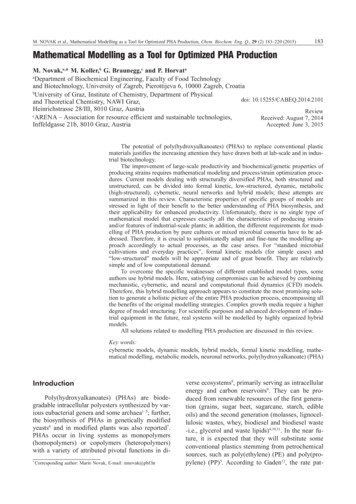
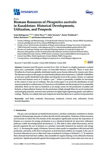
Resources 2020, 9, 745 of 25vulnerable to future water shortages than neighboring upstream countries. In addition to the competitionbetween upstream and downstream countries and regions, there is also competition for water betweenvarious water users within the country, such as natural ecosystems and irrigated agriculture [51,52].This is amplified against the background of ever-increasing water consumption due to a reasonablyhigh population growth rate. The depletion of water sources and their pollution, along with climatechange, contribute to further deterioration of sanitary and environmental conditions.3.2. Historical Distribution of Reed Bed Areas in KazakhstanOne of the first to publish data on areas under reed beds was the Institute of Economics of theAcademy of Sciences of the Kazakh SSR (Soviet Socialistic Republic), in 1962. Reed beds in the countryaccounted for about 1,042,000 ha (Table 2).Table 2. Reed bed areas distribution in different provinces of Kazakh SSR (source [53], 1958 citedin [54], 1964).Province Names *Reed BedsArea (ha)AverageProductivity(t ha 1 year 1 )Total Biomass(t year 1 latinskEast th 014,679,000Largest Reed Bed SitesIli River and tributaries of Lake BalkhashThe northern coast of the Caspian Sea, Rivers Embaand the UralSyr Darya River, Lake AschikulRivers Chu, Talas and Kuragaty, Lake BalkhashRivers Syr Darya and ChuIli River, Lakes Alakul and SasykkulTurgai River and Lakes Sarymoni, Zharkul, Sarykopa,and KamyshlykulRivers Temir, Emba and Big HobdaIrtysh River, Lakes Alakul and SasykkulIrtysh River and Lake ZaysanLake Tengiz, Ishim River and its tributariesIrtysh RiverTaldy RiverIshim River* The names of the provinces are given for the administrative-territorial division of Kazakh SSR until 1962.However, this area was corrected by [55] specifying it as the main reed beds of industrialimportance and recorded according to the data of the Institute of Economics, as well as the LandManagement Department of Regional Agricultural Administrations, the temporary scientific andtechnical commission of the State Scientific and Technical Committee of the Council of Ministers of theUSSR, and the Institute of Botany of the Academy of Sciences of the Republic of Kazakhstan in 1964.Moreover, according to [54] the Institute of Economics underestimated the reed bed area,since reed beds were taken into account only in 66 out of 192 administrative districts and onlyhigh-yielding reed beds available for industrial use were considered (See Appendix A for more detailedinformation). Hereupon, [54] included all provinces, as well as reed beds beyond the high yieldingones. Areas, productivity, and biomass stocks are given in Table 3. The estimated dry biomass stockfor the whole Kazakh SSR was nearly 17 million t.Figure 1 shows the reed bed distribution across Kazakhstan, as of 1964. Two-thirds of all reedbeds are located in the southern part as follows: in the basins of the Syr Darya, Shu, and Ili Rivers,and on the coast of the Caspian Sea, including the Ural Delta.
Resources 2020, 9, 746 of 25Table 3. Reed bed areas, productivity, and reed biomass stocks in various provinces of Kazakh SSR(source [54], 1964).Province NamesAlma-Ata okchetavSemipalatinskTselinogradEast KazakhstanNorth KazakhstanUralskPavlodarKaragandaTotalReed Beds Area ,0001,800,000Biomass Stocks (t)Including AccountedAverage Productivity(t ha 1 year 1 )TotalIncluding ,000* Due to territorial rearranges the Alma-Ata Province unites the so-called Alma-Ata and Taldy-Kurgan Provinces.Resources 2020, 9, x FOR PEER REVIEW7 of 28Figure 1.1. MapMap ofreed resourcesresources withinwithin thethe provincesprovinces ofof KazakhstanKazakhstan inin whitewhite (no(no data)data) andand gradientgradientFigureof (75,000t)andintensegreen(5.5milliongreen color for reed biomass range between light green (75,000 t) and intense green (5.5 million t).t).(Authors, DecemberDecember 20192019 basedbased onon [54],[54], 1964).1964).(Authors,Studies, conducted in 1979–1993, showed that the area occupied by high-yielding reed beds ofindustrial significance decreased by 70–95% in the Kzyl-Orda, Dzhambyl, Chimkent, and Alma-AtaProvinces as compared with the data of 1960 (Table 4), which are the provinces where the Syr Darya,Shu, and Ili River Basins are located. Reed beds in other provinces shrunk by 20–45% in areas and bycompared toto 1960.1960.40–50% in terms of yields as comparedTable 4. Changes in high-yielding reed beds of industrial significance in Kazakhstan from 1960 to1990/1993 (source [55]).ProvinceNamesAlma-AtaGuryevKzyl-OrdaReedBeds Area(ha)250,000170,000126,000Until 1960AverageProductivity(t ha 1 year 1)151515ProductionStock (t)3,750,0002,550,0001,890,000ReedBeds tivity(t ha 1 year 1)8.08.58.6ProductionStock (t)180,000433,50086,600
Resources 2020, 9, 747 of 25Table 4. Changes in high-yielding reed beds of industrial significance in Kazakhstan from 1960 to1990/1993 (source [55]).Until 19601990–1993Province NamesReed BedsArea (ha)Average Productivity(t ha 1 year 1 )ProductionStock (t)Reed BedsArea (ha)Average Productivity(t ha 1 year 1 )ProductionStock ganKustanaiAktyubinskUralskSemipalatinskEast th 0042,00024,50021,0002,352,7003.3. A Showcase of a Historical Overview of Reed Resources in the Ili DeltaThe Ili Delta is the only reed bed area, where the size and distribution of wetlands and reed bedareas were studied several times between the 1960s and today. These studies were done in the contextof construction and filling of the Kapchagay Reservoir in the 1970s and 1980s, which is upstream ofthe Ili Delta. Later, studies were done, as the Ili Delta became one of the largest rather undisturbedwetland complexes after the Aral Sea had desiccated and adjacent deltas had shrunk substantially [56].These studies tracked the changes of reed bed areas and related them to external factors, such asclimate and anthropogenic impacts, which eventually informed how other reed beds across Kazakhstancould have changed from the 1960s until today.Table 5 shows that the reed bed area in the Ili Delta dropped sharply from the 1960s until thebeginning of the 1990s, but has grown substantially until today. The former is clearly attributed tothe construction and filling of the Kapchagay Reservoir (see [56] and further literature there) and thecreation of the Akdala irrigation unit. After the Kapchagay Reservoir was not further filled, more waterwas released downstream into the Ili Delta, which caused reed beds to increase again. This processwas presumably supported by enhanced glacier melt in the headwaters and increased river runoffsas a result, which would be in line with a general trend of enhanced glacier melt in the course ofclimate change [57].Table 5. Changes in high-yielding reed beds of industrial significance in the Ili Delta from 1960to 2014/2015.YearsTotal ReedBeds Area (ha)Area ofProductionReed Beds (ha)AverageProductivity(t ha 1 year 1 )Total Biomass(t year 1 )ReferenceUntil idovskaya [54]Isambaev [55]Thevs et al. [28]The numbers in Table 5 are in line with a change detection of vegetation indices from Landsatsatellite images spanning from 1973 to 2013 [58]. The change detection revealed large areas of decreasingvegetation index from 1973–1990 and large areas of increasing vegetation index after 1990.The time period after 2000, with regard to wetland distribution in the Ili Delta and other RamsarSites in Kazakhstan, was covered by Tesch and Thevs [59]. From 2000 to 2018, the reed bed area hadnot changed or slightly increased in most Ramsar Sites, also in the Ili Delta. Despite this general
Resources 2020, 9, 748 of 25trend, there were fluctuations in reed bed areas within this time span. In the Ili Delta, after a period ofincreasing reed bed area until 2010, the area decreased from 2010 to 2015 but increased again after 2015.After Kazakhstan’s independence, agriculture and irrigation receded, and therefore more waterbecame available for natural riparian ecosystems in many river basins. Extrapolating these findingsfrom the Ili Delta to other wetlands and reed bed areas of Kazakhstan, it can be concluded that reedbed areas shrank from the 1960s until the 1990s, but afterwards increased their areas again, althoughnot reaching the sizes of the 1960s.4. Driving Forces of Wetlands and Reed Bed Areas Change in Kazakhstan4.1. Drivers of Wetlands and Reed Bed Areas Loss and DegradationThe most significant drivers of wetlands’ change in Kazakhstan are mainly anthropogenicactivities linked to the forms and scale of land use and water allocation in the basins of major rivers.Due to arid and semiarid climatic conditions, agriculture development in Kazakhstan and other CentralAsian countries largely depends on water supply from mostly big transboundary rivers. Deliberatediversion of their water from its ordinary course with further stream diversions and withdrawals isthe most pervasive way for irrigation. Although it contributes to the crop irrigation and land-useintensification, however, it often alters water regimes of wetlands and reed beds causing water levelsto recede drastically.According to Isambaev [55], regulation of the runoff of the Syr Darya, Talas, Chu, Ili, and KaratalRivers after 1960 with the expansion of irrigated agriculture contributed to the absence of spring-summerfloods along the rivers and lead to dramatic shrinking of reed bed areas (see Table 4). Thus, intensificationof land use along major rivers and mainly in their upper catchment area resulted in water scarcity inthe dry areas at the lower reaches, which are especially sensitive to water fluctuations. Furthermore,it resulted in ecological problems, such as land and vegetation degradation and biodiversity loss,as recent studies have revealed dramatic environmental, morphological, and areal changes of differentCentral Asian inland water bodies and lakes in the past decades [45,60–62]. Under these circumstances,terminal lakes and wetlands with reed bed areas in the semi-desert zone of Kazakhstan are regardedthreatened due to an intensification of water use.Fire is another significant threat for the reed beds that are located on non-submerged sites, meadowvegetation, parts of the Tugai forests, and shrub vegetation and their associated fauna. Fires are ignitedby local people mainly in reed beds and partly other vegetation types to remove dead biomass,and thus enhance the productivity of reed to use it as pasture or hay meadow. Traditionally, such fireswere most often ignited in winter or early spring, and usually with control for the least threat tofauna. However, today some fires are also ignited in summer and often get out of control [63,64].Such uncontrolled fires destroy the habitat of wildlife (mainly mammals and birds) and decrease theproductivity of the vegetation.4.2. Drivers of Wetlands and Reed Beds Area Protection and Wise UseWetlands across Central Asia have been experiencing long-term degradation and are amongthe regions which are most severely affected by land degradation [59]. In particular, during the20th and early 21st centuries, the rate of wetlands degradation dramatically increased due to humanintervention. The most prominent example is the Aral Sea with the deltas of its main tributaries, theAmu Darya in Uzbekistan and the Syr Darya in Kazakhstan. Their desiccation has resulted fromincreased water diversion further upstream for irrigated agriculture. Environmental changes areobserved in all-natural climatic zones, gradually intensifying downstream in the rivers and mostsignificantly in the zone of runoff consumption. Subsequently, the Tengiz-Korgalzhyn Lakes Systemand Lakes in the Lower Irgiz and Turgai Rivers were the first sites located on the territory of the formerKazakh SSR that have been simultaneously listed on the Ramsar list by the Soviet Union Government,when it joined that convention in 1975 [65]. Both wetlands were relisted after the ratification of the
Resources 2020, 9, 749 of 25Convention by Kazakhstan as an independent state. The first site was confirmed in 2007 and the secondseparately in September 2011. Currently, the list of Ramsar sites in Kazakhstan has been increased toten sites (Table 6) that have been declared as wetlands of international importance, with a total area of3,281,398 ha [66].Table 6. Wetland and reed bed sites of Kazakhstan recorded into the Ramsar list (source [66]). NameDate of RecordProvinceArea of theRamsar Site (ha)Protected Areas1Tengiz-KorgalzhynLake System11 October 1976Akmola Province353,341Korgalzhyn StateNature Reserve2Lakes of the lowerTurgay and Irgiz11 October 1976Aktobe Province348,000Irgiz-Turgai Reserve,Turgai NatureSanctuary ofRepublicanImportance3Ural River Delta andthe adjacent CaspianSea coast10 March 2009Atyrau Province111,500“Akzhayik” NatureReserve4Koibagar-TyuntyugurLake System7 May 2009Qostanai Province58,000-5Kulykol-TaldykolLake System7 May 2009Qostanai Province8300-6Zharsor-UrkashLake System12 July 2009Qostan
resources Review Biomass Resources of Phragmites australis in Kazakhstan: Historical Developments, Utilization, and Prospects Azim Baibagyssov 1,2,3,*, Niels Thevs 2,4, Sabir Nurtazin 1, Rainer Waldhardt 3, Volker Beckmann 2 and Ruslan Salmurzauly 1 1 Faculty of Biology and Biotechnology, Al-Farabi