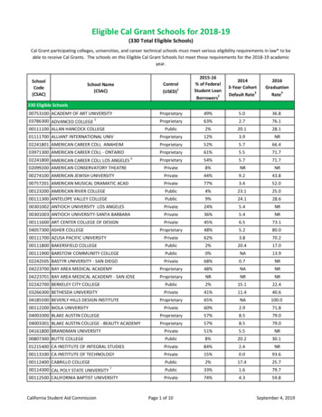
Transcription
Arlington Public SchoolsSocial Studies Curriculum 2016GRADE 8: World GeographyACKNOWLEDGEMENTSThe Social Studies Office acknowledges the contributions made to the development of these materials byall social studies staff and especially the following people:Kindergarten: Our CommunityMary Cantwell, Anna Maria Lechleitner, Juanita WadeGrade 1: Our StateMarijoy Cordero, Gina Samara, Jaclyn ScottGrade 2: Our CountryJennifer Burgin, Anna Kanter, Maryellen Meden, Eric SokoloveGrade 3: Ancient World CulturesKim Dinardo, Tara Mitchell, Christine Williams, Tricia ZipfelGrade 4: Virginia StudiesMercedes Dean, Lauren Elkins, Karen Magestad, Kristen WollaGrade 5: Ancient WorldGreg Chapuis, Casey Dolan, Nicholas Fernandez, Michelle JaeckelGrade 6: U.S. History, Civics and Economics to 1865Patricia Carlson, Breonna McClain, Anne Miller, Tiffany Mitchell, Sara WinterGrade 7: U.S. History, Civics and Economics 1865 to PresentJesse Homburg, Rachel Payne, Lilo Stephens, Patty Tuttle-NewbyGrade 8: World GeographyAllie Bakaj, Christine Joy, Maureen Nolan, Sarah StewartGrade 9: World History II from 1500 A.D.Jen Dean, Jeana Norton, Anne StewartGrade 10: World History I to 1500 A.D.Julie Bell, Kathleen Claassen, Caitlin DoddsGrade 11: U.S. and Virginia HistoryKevin Bridwell, Greg Cabana, Erica Drummond, Kevin PhillipsGrade 12: U.S. and Virginia GovernmentDiane Boudalis, Michelle Cottrell-Williams, Patricia HuntDiana JordanBarbara Ann LavelleCathy Bonneville HixSocial Studies Supervisor
Arlington Public SchoolsSocial Studies Curriculum 2016GRADE 8: World GeographyCOURSE DESCRIPTION: The course of study for grade eight is World Geography. The focus of this course is the study of the world’s peoples,places, and environments, with an emphasis on world regions. The knowledge, skills, and perspectives of the course are centered on the world’speoples and their cultural characteristics, landforms and climates, economic development, and migration and settlement patterns. Spatialconcepts of geography will be used as a framework for studying interactions between humans and their environments. Using geographicresources, students will employ inquiry, research, and technology skills to ask and answer geographic questions. Particular emphasis will beplaced on students understanding and applying geographic concepts and skills to their daily lives.THEME: The organizing theme for grade eight is INTERACTION.KEY CONCEPTS: Students will learn that INTERACTION defines the network of the language, themes and tools of geography used to study both the past and present world (GeographicSkills). describes the intersection of positions on the earth’s surface, including the major physical and cultural features of each region (PlaceGeography). describes the climate, topography, biogeography, natural resources, and processes that shape patterns on the earth’s surface(Physical Geography). connects the features of a society as a way of life and the variance of these over time and place (Cultural Geography). links the ways people make a living with the ways they trade with each other (Economic Geography). relates politics and territory with the development of political structures over place and time (Political Geography). conveys the impact of location and development on urban, suburban, and rural areas over time and place (Urban Geography). explains society is interplay with the natural environment on local, regional, and global scales (Environmental Geography). illustrates the geography of the past and how geographic patterns have changed over time (Historical Geography).UNITS and UNIT SECTIONS:I.Introduction to GeographyThis unit introduces the student to basic geography. the five themes of geography the different types of geography geographic vocabulary global place geography the use of the textbook and a variety of resources
Arlington Public SchoolsSocial Studies Curriculum 2016GRADE 8: World GeographyII.Physical Geography and Geographic SkillsIn this unit, students will demonstrate skills for historical thinking, geographical analysis, economic decision making, and responsible citizenshipby: synthesizing evidence from artifacts and primary and secondary sources to obtain information about the world’s countries, cities,and environments; using geographic information to determine patterns and trends to understand world regions; creating, comparing, and interpreting maps, charts, graphs, and pictures to determine characteristics of world regions; evaluating sources for accuracy, credibility, bias, and propaganda; using maps and other visual images to compare and contrast historical, cultural, economic, and political perspectives; explaining indirect cause-and-effect relationships to understand geospatial connections; analyzing multiple connections across time and place; and investigating and researching to develop student-produced productsorally and in writing.In this unit students will analyze how physical and ecological processes shape Earth’s surface by: explaining regional climatic patterns and weather phenomena and their effects on people and places; describing how humans influence the environment and are influenced by it; and explaining how technology affects one’s ability to modify the environment and adapt to it.III.Cultural GeographyIn this unit students will apply the concept of a region by: explaining how characteristics of regions have led to regional labels; describing how regional landscapes reflect the physical environment and cultural characteristics of their inhabitants; analyzing how cultural characteristics, including the world’s major languages, ethnicities, and religions, link or divide regions; explaining how different cultures use maps and place names to reflect their regional perspectives; and developing and refining mental maps of world regions.In this unit students will apply social science skills to analyze past and present trends in human migration and cultural interaction diffusion by: determining how they are influenced by social, economic, political, and environmentalfactors.; and determining how they influence the current human characteristics of places and regions.In this unit students will apply social science skills to analyze how forces of conflict and cooperation affect the division and control of Earth’ssurface by: explaining and evaluating reasons for the creation of different political divisions; and describing ways cooperation among political jurisdictions is used to solve problems and settle disputes.
Arlington Public SchoolsSocial Studies Curriculum 2016GRADE 8: World GeographyIV. Demographics, Economics & Political GeographyIn this unit students will apply social science skills to evaluate the significance of natural, human, and capital resources by: comparing the distribution of major natural resources throughout world regions; showing their influence on patterns of economic activity and land use; and evaluating perspectives regarding the use of resources.In this unit students will apply social science skills to compare and contrast the distribution, growth rates, and characteristics of humanpopulation by: examining demographic data to determine the relative level of development; distinguishing between developed and developing countries; and comparing and contrasting the level of economic development to the standard of living and quality of life.In this unit students will apply social science skills to analyze the patterns of urban development by: applying the concepts of site and situation to major cities in each region; explaining how the functions of towns and cities have changed over time; and describing the unique influence of urban areas and challenges they face.In this unit students will apply social science skills to analyze the impact of globalization by: identifying factors, including comparative advantage, that influence the distribution of economic activities and trade; describing ways that economic and social interactions change over time; and mapping, describing, and evaluating economic unions.V. United States and CanadaIn this unit students will analyze the characteristics of the United States and Canada by: identifying and analyzing the location of major geographic regions and major cities on maps and globes; describing major physical and environmental features; explaining important economic characteristics; and recognizing cultural influences and landscapes.VI.Latin America and the CaribbeanIn this unit students will analyze the characteristics of the Latin America and the Caribbean region by: identifying and analyzing the location of major geographic regions and major cities on maps and globes; describing major physical and environmental features; explaining important economic characteristics; and recognizing cultural influences and landscapes.
Arlington Public SchoolsSocial Studies Curriculum 2016GRADE 8: World GeographyVII.EuropeIn this unit students will analyze the characteristics of the European region by: identifying and analyzing the location of major geographic regions and major cities on maps and globes; describing major physical and environmental features; explaining important economic characteristics; and recognizing cultural influences and landscapes.VIII.Russia and Central AsiaIn this unit students will analyze the characteristics of the Russian and Central Asian regions by: identifying and analyzing the location of major geographic regions and major cities on maps and globes; describing major physical and environmental features; explaining important economic characteristics; and recognizing cultural influences and landscapes.IX.Sub-Saharan AfricaIn this unit students will analyze the characteristics of the Sub-Saharan Africa region by: identifying and analyzing the location of major geographic regions and major cities on maps and globes; describing major physical and environmental features; explaining important economic characteristics; and recognizing cultural influences and landscapes.X.North Africa and Southwest AsiaIn this unit students will analyze the characteristics of the North African and Southwest Asian regions by: identifying and analyzing the location of major geographic regions and major cities on maps and globes; describing major physical and environmental features; explaining important economic characteristics; and recognizing cultural influences and landscapes.XI.South and Southeast AsiaIn this unit students will analyze the characteristics of the South and Southeast Asian regions by: identifying and analyzing the location of major geographic regions and major cities on maps and globes; describing major physical and environmental features; explaining important economic characteristics; and recognizing cultural influences and landscapes.
Arlington Public SchoolsSocial Studies Curriculum 2016GRADE 8: World GeographyXII. East AsiaIn this unit students will analyze the characteristics of the East Asian region by: identifying and analyzing the location of major geographic regions and major cities on maps and globes; describing major physical and environmental features; explaining important economic characteristics; and recognizing cultural influences and landscapes.XIII. Australia and the Pacific IslandsIn this unit students will analyze the characteristics of the Australian and Pacific Island regions by: identifying and analyzing the location of major geographic regions and major cities on maps and globes; describing major physical and environmental features; explaining important economic characteristics; and recognizing cultural influences and landscapes.
Arlington Public SchoolsSocial Studies Curriculum 2016GRADE 8: World GeographyUNIT I: Introduction to GeographySTANDARDS OF LEARNING: This unit will address the following objectives:Note: Power Standards below are indicated in bold.SOL WG.1The student will demonstrate skills for historical thinking, geographical analysis, economic decision making, and responsible citizenship by:a) synthesizing evidence from artifacts and primary and secondary sources to obtain information about the world’s countries, cities,and environments;b) using geographic information to determine patterns and trends to understand world regions;c) creating, comparing, and interpreting maps, charts, graphs, and pictures to determine characteristics of world regions;d) evaluating sources for accuracy, credibility, bias, and propaganda;e) using maps and other visual images to compare and contrast historical, cultural, economic, and political perspectives;f) explaining indirect cause-and-effect relationships to understand geospatial connections;g) analyzing multiple connections across time and place;h) using a decision-making model to analyze and explain the incentives for and consequences of a specific choice made;i) identifying the rights and responsibilities of citizenship and the ethical use of material or intellectual property; andj) investigating and researching to develop products orally and in writing.ENDURING UNDERSTANDING: The interaction of humans with their environment affects the development of a region.CONCEPTUAL UNIT QUESTIONS (Essential Questions): What is geography? What are the essential terms needed to study geography?PREVIEW ACTIVITY: Students are asked to draw a map of the world using only their own mental map of the world. Students are encouraged tostart with what they know and work out from that point. Praise and encouragement are offered for placing items in the correct hemisphere orregion, not necessarily artistic skill.These maps are stored until the end of the year. At that point, students will repeat the activity to visualize their progress.Each student should get a blank sheet of paper and a copy of the student directions, which can be found in the Introduction to Geography folderfrom this link: https://drive.google.com/open?id 0BySl24GaKHVdMDlCc19rWVNzRFkTEXTBOOK ALIGNMENT: SEE FILES
Arlington Public SchoolsSocial Studies Curriculum 2016GRADE 8: World GeographyPACING GUIDE:UNITTIME FRAMEDATESI.Introduction to Geography4-5 daysSeptemberII.Physical Geography and Geographic Skills20 daysSeptemberIII.Cultural Geography10-15 daysOctoberIV.Demographics, Economics and Political Geography25 daysNovember/DecemberV.United States and Canada3 daysThe remaining units follow a regionalapproach. The sequence of regions variesVI.Latin America and the Caribbean15 daysdepending on factors such as availableVII.Europe10 daysresources within your school, current events,VIII.Russia and Central Asia4 daysand integration with core subjects.IX.Sub-Saharan Africa15 daysX.North Africa and Southwest Asia10 daysXI.South and Southeast Asia15 daysXII.East Asia15 daysXIII.Australia and Pacific Islands1 dayLITERATURE AND OTHER RESOURCES:LITERATUREScholastic New York Times UPFRONT News Magazine. This is a magazine, which can be ordered using textbook money or a PTA Grant. Ithas great current event articles, editorial cartoons, and debate features. Useful for all units.WEBSITESNewsELAhttps://newsela.com/This site is great for current event articles that can be matched to students according to lexile level. It is a very good resource and useful for allunits.Sheppard Softwarehttp://www.sheppardsoftware.com/European Geography.htmThis website allows students to quiz themselves on maps of the world.Sporclewww.sporcle.comThis is a quiz site for practically everything including history and geography.Geoguessrwww.geoguessr.comThis is a web based geography game using images. Students must carefully analyze an image and then determine where the image was taken.Also uses Google Earth.Kahoothttps://kahoot.it/#/
Arlington Public SchoolsSocial Studies Curriculum 2016GRADE 8: World GeographyThis allows teachers to build interactive quizzes that can be used for review. Students can play using their smart phone and teachers are able todownload the results in a spreadsheet at the end of each class to see what students know and where they are struggling. All students participate!Quizlethttps://quizlet.comOnline flashcards for vocabulary practice. Students can create their own or the teacher can create them and give the link to students. Appavailable for iPhones and iPads.CIA he-world-factbook/This site is great for researching demographics, economics and politics of all countries.Gapminderhttp://www.gapminder.org/This site contains graphs of demographics.The following databases are provided by APS library s databaseWorld History in Context databaseOpposing Viewpoints in Context databaseTapQuiz Maps (app for studying country locations)SUMMARY OF KEY TERMS/PEOPLE: The following list of terms reflects some of the important vocabulary and individuals students shouldknow to successfully understand course content and pass the SOL exams.BOLDED terms are “must have” words or those most essential. Plain Font terms are “good to know” for a deeper sInhabitantsLocationPrime rctic OceanSatellite imagesDiagramsDiversityIncentivesPrimary SourcesData basesField WorkConsequencesPerspectiveMovementHuman EnvironmentInteractionHuman GeographyPhysical GeographyLatitudeLongitudeAsiaAtlantic OceanAbsolute LocationAustraliaRelative LocationEuropePacific OceanIndian OceanSouthern OceanSouth AmericaNorth AmericaSAMPLE LESSONS: https://drive.google.com/a/apsva.us/folderview?id 0BySl24GaKHVdVnFhdFUtdlliREE&usp sharingSOL ESSENTIAL UNDERSTANDINGS, QUESTIONS, CONTENT and SKILLS: The following pages, from the State’s Curriculum Framework,outline the essential understandings, questions, knowledge and skills related to the SOLs. They provide the base from which the content in thisunit is studies.
Arlington Public SchoolsSocial Studies Curriculum 2016GRADE 8: World GeographySTANDARD WG.1aThe student will demonstrate skills for historical thinking, geographical analysis, economic decision making, and responsiblecitizenship bya) synthesizing evidence from artifacts and primary and secondary sources to obtain information about the world’s countries, cities,and environments;Essential UnderstandingsSynthesizing involves combiningprocessed information with otherknowledge to logically reach anew interpretation andunderstanding of content.Primary and secondary sourcesenable us to examine evidenceclosely and to place it in abroader context.An artifact is an object or tool thattells us about the people from thepast.A primary source is an artifact,document, image, or other sourceof information that was createdduring the time under study.A secondary source is adocument, image, or other sourceof information that relates ordiscusses information originallypresented elsewhere.Experiences may include but are not limited to the following: Use a variety of sources to collect information about a location. Describe the impact of the location’sgeography on its social and cultural development. Tools and sources to consider for data collectionmay include the following:o GIS (Geographic Information Systems)o Field worko Satellite imageso Photographso Maps, globeso Databaseso Primary sourceso Diagrams Examine and analyze information about cities, countries, regions, and environments. Use theinformation gathered to gain a new and deeper understanding of inhabitants, resources, land and waterusage, transportation methods, and communications. Examine and analyze geographic information and demographic data. Use the information gathered togain a new and deeper understanding of economic development.
Arlington Public SchoolsSocial Studies Curriculum 2016GRADE 8: World GeographySTANDARD WG.1bThe student will demonstrate skills for historical thinking, geographical analysis, economic decision making, and responsiblecitizenship byb) using geographic information to determine patterns and trends to understand world regions;Essential UnderstandingsExperiences may include but are not limited to the following:Analyzing and interpreting involves Use a variety of sources to collect information about a location. Describe how people haveidentifying the important elements ofadapted to the earth’s features. Tools and sources to consider for data collection may include thegeographic sources in order to makefollowing:inferences and generalizations ando GIS (Geographic Information Systems)draw conclusions.o Field worko Satellite imagesKnowledge of geography ando Photographsapplication of geographic skills enableo Maps, globesus to understand relationships betweeno Charts and graphspeople, their behavior, places, and theo Databasesenvironment for problem solving ando Primary sourceshistorical understanding.o Diagrams Analyze the relationship between physical and human geography.The physical geography of a location Analyze geographic information related to the movement of people, products, resources, ideas,had a direct impact on the lives ofand language to determine patterns and trends.people in world regions and how they Examine maps of a location before and after a major conflict to discuss how the conflictadapted to their environment.influenced the social, political, and economic landscapes of the region. Use maps to explain how the location of resources influences the patterns, trends, and migrationFive Themes of Geographyof the population. Location: Defined according to itsposition on the earth’s surface; where isit?Place: Locations having distinctivefeatures that give them meaning andcharacter that differ from otherlocations; what is it like?Region: A unit on the earth's surfacethat has unifying characteristics; howare places similar or different?Movement: The way people, products,and information move from one place toanother; how do people, goods, andideas move from one location toanother?Human-Environment Interaction: Therelationship between people and theirenvironment; how do people relate tothe physical world?
Arlington Public SchoolsSocial Studies Curriculum 2016GRADE 8: World GeographySTANDARD WG.1cThe student will demonstrate skills for historical thinking, geographical analysis, economic decision making, and responsiblecitizenship byc) creating, comparing, and interpreting maps, charts, graphs, and pictures to determine characteristics of world regions;Essential UnderstandingsInterpreting involves the processof explaining or translatinginformation.Interpreting begins withobservation of data and thenrequires students to extractsignificant information embeddedwithin data in order to drawconclusions.Experiences may include but are not limited to the following: Interpret a variety of thematic maps to draw conclusions about a region or country. Gather information from a variety of sources to create a chart or graph depicting characteristics of aworld region. Gather information about the push and pull factors of a region. Create a chart differentiating betweeneconomic, political, and social factors.
Arlington Public SchoolsSocial Studies Curriculum 2016GRADE 8: World GeographySTANDARD WG.1dThe student will demonstrate skills for historical thinking, geographical analysis, economic decision making, and responsiblecitizenship byd) evaluating sources for accuracy, credibility, bias, and propaganda;Essential UnderstandingsIt is critical to determine theaccuracy and validity ofinformation and recognize bias todraw informed conclusions, solveproblems, and make informeddecisions.The context from the time periodof a primary or secondary sourcecan influence the informationincluded.Facts can be verified withevidence while opinions cannot.Bias is partiality in favor of oragainst one thing, person, orgroup compared with another.Experiences may include but are not limited to the following: Develop criteria or questions to evaluate a source. Consider the following when evaluating a source:o Timeliness of the informationo Importance of the informationo Source of the informationo Reliability, truthfulness, and correctness of the contento Reason the information exists Select a current issue or regional concern. Explore multiple sources that report the same event, issue,or concern. Examine the information to determine the accuracy and validity of the sources. Events,issues, or concerns may include the following:o War conflicto Immigrationo Environmental issueso Geographic boundaries
Arlington Public SchoolsSocial Studies Curriculum 2016GRADE 8: World GeographySTANDARD WG.1eThe student will demonstrate skills for historical thinking, geographical analysis, economic decision making, and responsiblecitizenship bye) using maps and other visual images to compare and contrast historical, cultural, economic, and political perspectives;Essential UnderstandingsThe skill of comparing andcontrasting perspectives involvesbreaking down information andthen categorizing it into similarand dissimilar pieces.Experiences may include but are not limited to the following: Select an environmental issue (e.g., recycling, air pollution, water scarcity). Gather information from avariety of sources (e.g., executive orders; foreign policy outlines; political, business, or environmentalWeb sites; social or political blogs with an environmental focus). Compare and contrast varyingperspectives on the issue to gain an understanding of historical, cultural, political, and regionalperspectives, including the following:o The impact on the inhabitants of the regiono Policies to regulate, encourage, or discontinue activities Create a post for a social media platform highlighting an issue of environmental concern or benefit.
Arlington Public SchoolsSocial Studies Curriculum 2016GRADE 8: World GeographySTANDARD WG.1fThe student will demonstrate skills for historical thinking, geographical analysis, economic decision making, and responsiblecitizenship byf) explaining indirect cause-and-effect relationships to understand geospatial connections;Essential UnderstandingsA cause-and-effect relationship isa relationship in which one event(the cause) makes another event(the effect) happen. There can bemultiple causes and effects.An indirect cause-and-effectrelationship usually takes time toestablish. Such relationships areoften unforeseen, unplanned, orconnected to the main causesand effects.Explaining includes justifying whythe evidence credibly supportsthe claim.Diversity creates a variety ofperspectives, contributions, andchallenges.Experiences may include but are not limited to the following: Apply a process for explaining indirect cause-and-effect relationships, such as the following:o Choose an established effect and brainstorm causes.o Categorize the causes into direct or indirect causes.o Describe direct and indirect items separately.o Compare and contrast direct and indirect causes.o Identify the most important difference between the direct and indirect causes.o Draw conclusions about the impact on people, places, and events.o Discuss, defend, and refine conclusions. Compare charts, graphs, and/or maps to determine the role diversity played in affecting the social,economic, and political structures ofo a regiono standard of living/quality of lifeo developing/developed countries. Create flow charts, storyboards, and timelines to explore multiple causes and effects. Determine how the choices of selected people/groups influenceo a regiono standard of living/quality of lifeo developing/developed countries. Examine both intended and unintended consequences of an event, including the following questions:o What was the context for the event to take place?o What actions were taken?o What was the result of these actions?
Arlington Public SchoolsSocial Studies Curriculum 2016GRADE 8: World GeographySTANDARD WG.1gThe student will demonstrate skills for historical thinking, geographical analysis, economic decision making, and responsiblecitizenship byg) analyzing multiple connections across time and place;Essential UnderstandingsAnalyzing includes identifying theimportant elements of a topic.Analytical thinking is furtherstrengthened when connectionsare made between two or moretopics.Experiences may include but are not limited to the following: Research a regional issue. Create a timeline or graphic organizer to illustrate how that issue haschanged over time. Organize significant historical events and people that have influenced the issue.Issues may include the following:o Movemento Regiono Human-environment interactionso Location and place Identify how cultures change to reflect the following:o Advancementso Conflictso Diversityo Movements and migrationso Human-environment interactions
Arlington Public SchoolsSocial Studies Curriculum 2016GRADE 8: World GeographySTANDARD WG.1hThe student will demonstrate skills for historical thinking, geographical analysis, economic decision making, and responsiblecitizenship byh) using a decision-making model to analyze and explain the incentives for and consequences of a specific choice made;Essential UnderstandingsDecision-making models serveseveral purposes. They can helpus make decisions for the future better understand the choicespeople faced in the past analyze the outcomes of thedecisions that people alreadymade.Decision making involvesdetermining relevant andirrelevant information.Effective decision-making models compare the expected costsand benefits of alternativechoices identify the costs and benefitsof specific choices made.Incentives are actions or rewardsthat encourage people to act.When incentives change,behavior changes in predictableways.Experiences may include but are not limited to the following: Use a PACED (Problem, Alternatives, Criteria, Evaluate, Decision) decision grid:Problem: Rural Brazilian residents making a choice to migrateCriteriaIncomeFamily impactTransportationAlternativesR
GRADE 8: World Geography COURSE DESCRIPTION: The course of study for grade eight is World Geography. The focus of this course is the study of the world’s peoples, places, and environments, with an emphasis on world regions. The knowledge, skills, and perspectives o