Transcription
Preliminary Assessment/Site InspectionBarite Hill/Nevada GoldfieldsMcCormick CountySCD 987 597 903December 15, 2006Prepared By: Timothy Kadar Reviewed By: Jonathan MclnnisSite Assessment SectionBureau of Land & Waste ManagementSouth Carolina Department of Health & Environmental Control2600 Bull StreetColumbia, SC 29201
Barite Hill/Nevada GoldfieldsSCD 987 597 903Page 1I.SCOPE OF WORKUnder authority of the Comprehensive Environmental Response, Compensation, and Liability Act of1980 (CERCLA) and the Superftind Amendments and Reauthorization Act of 1986 (SARA), the SiteAssessment Section of the South Carolina Department of Health and Environmental Control(SCDHEC) conducted a Preliminary Assessment/Site Inspection of the Barite Hill/NevadaGoldfields site in McCormick County, South Carolina. The scope of the investigation included areview of available file information, a site reconnaissance, a sampling trip, and a target survey. Aspart of this investigation, 12 surface water samples and 17 soil/sediment samples were collected fromonsite and off-site surface waters, soils, and sediments. The primary objective of this investigationwas to determine the site's potential impact to the surface water pathways associated with the site.II.INTRODUCTIONThe Barite Hill/Nevada Goldfields site is located approximately 3 miles south of McCormick, SouthCarolina between US 378 and US 221 on the northern side of Road 30 in McCormick County, SouthCarolina. The mine site is relatively remote; there are no buildings, homes, or commercial buildingswithin 0.5 miles of the boundary. The site actively mined gold from 1991 to 1995. From 1995 untilNevada Goldfields filed for Chapter 7 Bankruptcy in 1999, the reclamation of the site was beingaddressed by Nevada Goldfields. On July 7, 1999 Nevada Goldfields handed the facility's keys toSCDHEC and abandoned the site.The site is located along a topographic high ridge area forming the headwaters of an unnamedtributary to Hawes Creek. The topography of the area consists of rolling hills with ridgelines at anelevation of about 500 feet. Within the site, the ridgeline comprising the site has a high point ofabout 510 feet and an average elevation of approximately 480 feet.The permitted mine site totals 795.2 acres. Of this total, 659.7 acres are designated as buffer area(areas not disturbed beyond the pre-mine natural state); therefore the maximum disturbance area is135.5 acres.The facility used a cyanide solution in a heap leach process to extract gold from ore. There are 7processing ponds onsite containing an unknown amount of free-liquids. Three large, multi-acre,waste rock piles contaminated with cyanide are left onsite. Each waste rock pile has the potential forproducing acid. Storm water run on and runoff are not controlled at the site. The Main Pit from themining operations remains. The pit contains approximately 100 million gallons of water with a pHof 2 2.2 and a high dissolved metal content. Seeps from the main pit containing acidic water withhigh dissolved metal content is being released to the northern unnamed tributaries of Hawes Creekwhich borders the pit.A SI was conducted on December 8, 2003, which included surface water and sediment samples.Instrumentation interference caused by high concentrations of metals in the samples adversely
Barite Hill/Nevada GoldfieldsSCD 987 597 903Page 2affected the data quality of the results. The site was re-sampled as an ESI on the week of September26,2004. ESI sample results for surface water, sediments, and soils detected several elevated metals(arsenic, cobalt, copper, cyanide, iron, lead, manganese, selenium, and zinc) both on-site and offsite.In addition to the surface water, sediment, and on-site soil samples, portions of the site were screenedutilizing a field portable InnovX XL440 XRF. XRF screening results for the on-site soils samplesdetected several elevated metals (arsenic, cobalt, copper, lead, selenium, and zinc) in the formerasphalt leach pad area.The main pit contains approximately 100 million gallons of water with a high metal loading contentand a pH of 2 to 2.2 standard units.III.SITE BACKGROUND AND HISTORYOwnership HistoryThe Barite Hill/Nevada Goldfields site mined gold from 1991 to 1994 and silver from 1991 to 1992.Nevada Goldfields filed Chapter 7 Liquidation with the United States Bankruptcy Court, District ofDelaware on June 25, 1999. They abandoned the site on July 7, 1999 (Ref. 5, 6, 7).The disturbed area of the Barite Hill/Nevada Goldfields site is currently divided into three parcels ofland (Ref. 3, 8).Property Description:McCormick County Tax Maps128-000-00-005, 148.1 acres128-000-00-004, 55.7 acres128-000-00-003, 43.59 acresCurrent Owner of site:Tax Map 128-000-00-005Gwalia (USA) Ltd.PO Box 1530McCormick, SC 29835Pete K. Lalor - Gwalia in 1998 (no longer on the Board38-40 Parliament PlaceWest PerthWestern Australia 6005Represented by:CT Corp System (last known Registered Agent - 1998)75 Beattie Place, Two Shelter CentreGreenville, SC 29602
Barite Hill/Nevada GoldfieldsSCD 987 597 903Page 3Corporation Information:(Currently Active)Gwalia Resources (International) Limited38-40 Parliament PlaceWest Perth, PO Box 669West PerthWestern Australia 6005History:Gwalia (USA) Ltd acquired this parcel via sale and land swapwith Bo water (Catawba Timber).Current Owner of site:Tax Map 128-000 00-004Gwalia (USA) Ltd.PO Box 1530McCormick, SC 29835Pete K. Lalor - Gwalia in 1998 (no longer on the Board38-40 Parliament PlaceWest PerthWestern Australia 6005Represented by:CT Corp System (last known Registered Agent - 1998)75 Beattie Place, Two Shelter CentreGreenville, SC 29602Corporation Information:(Currently Active)Gwalia Resources (International) Limited38-40 Parliament PlaceWest Perth, PO Box 669West PerthWestern Australia 6005History:Gwalia (USA) Ltd acquired this parcel from the U.S. ForestService via Exchange Deed.Current Owner of site:Tax Map 128-000-00-004Rainsford & Sons, A General Partnership, c/o Benjamin Rainsford25 Cantelou RoadEdgefield, SC 29824History:The property has been owned by Rainsford & Sons since 1975.
Barite Hill/Nevada GoldfieldsSCD 987 597 903Page 4Pertinent Regulatory ActivitySCDHEC Permits - Permit to Construct (No. 17,334-IW), 7-24-92; Permit to Operate, 9-281992; Permit to Operate, 3-1-1993; NPDES (No. SC0043401), 10-12-1989, Air Quality Permit(No. 1600-0006-CA, CB, CC, CD, and CE, 6-12-1990.SCRLRCC Permit - Permit for Mining Operation (No. 0852), 8-14-1990.SCDHEC Notice of Violation (NOV), (each date is a separate notice) 8-25-95, 6-27-96, 10-301996, and 3-11-1997.SCDHEC Consent Order 98-049-W, 6-11-1998Description and SettingThe Barite Hill/Nevada Goldfields site is located approximately 3 miles south of McCormick, inMcCormick County, South Carolina. Strom Thurmond Lake on the Savannah River isapproximately 3 miles west of the site. The mine site is relatively remote; there are no buildings,homes, or commercial buildings within 0.5 miles of the boundary (Ref. 3, 9, 10).The site is located along on a topographic high ridge area forming the headwaters of an unnamedtributary to Hawes Creek. The topography of the area consists of rolling hills with ridgelines at anelevation of 500 about feet. Within the site, the ridgeline comprising the site has a high point ofabout 510 feet and an average elevation of approximately 480 feet (Ref. 3, 9, 10).The permitted mine site totals 795.2 acres. Of this total, 659.7 acres are designated as buffer area(areas not disturbed beyond the pre-mine natural state); therefore the maximum disturbance area is135.5 acres (Ref. 3,9).The facility used a cyanide solution in a heap leach process to extract gold from ore. There are 7processing ponds onsite containing an unknown amount offree-liquidspotentially contaminated withcyanide. Three large, multi-acre, waste rock piles contaminated with cyanide are left onsite. Eachwaste rock pile has the potential for producing acid. Storm water run on and runoff are notcontrolled at the site. The Main Pit from the mining operations remains. The pit containsapproximately 100 million gallons of water with a pH of 2 2.2 and the probability of a highdissolved metal content. Runoff from the site could contain a cyanide bearing solution or acidicwater with high dissolved metal content. This runoff could be impacting wetlands and the unnamedtributaries of Hawes Creek that surround the site (Ref. 3, 9, 10, 11, 12).
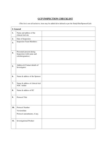
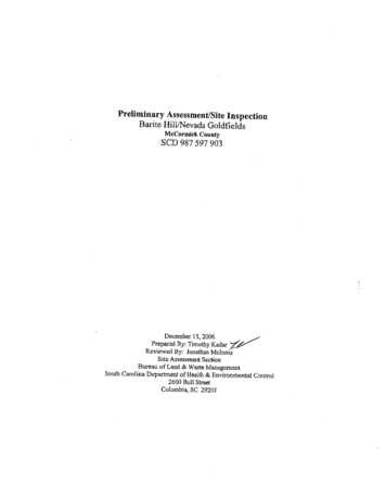
Barite Hill/Nevada GoldfieldsSCD 987 597 903Page 5Figure 1 - General Site Layout
Barite Hill/Nevada GoldfieldsSCO 987 597 903Page 6Process and Waste Disposal HistoryThe ore was mined using conventional open pit methods. Rock was first fractured using drilling andblasting, and then loaded into haul trucks by diesel-powered front-end loaders. Waste rock was thenhauled and used as fill for facility construction or hauled and dumped in the waste rock disposalareas. Ore was hauled to the crushing area where processing for the cyanide heap-leach methodbegan. The ore was crushed to minus 3/4-inch and agglomerated with cyanide and cement. Thecrushed and agglomerated ore was then placed on pads using a conveyor and radial stacker system.A dilute cyanide solution was then sprayed over the heaps and allowed to percolate through the ore,thereby dissolving the gold into solution (Ref. 9, 10, 14).The gold bearing (or pregnant) solution from the pads drained from the bottom of the heaps and wasrouted either to the process plant, or returned to the heaps to increase the solution's gold content. Atthe process plant, gold recovery from the process solution began by the adsorption of the dissolvedgold onto activated carbon. The loaded carbon was then stripped by an electro winning process.Electro-deposited gold was then melted to from dore' bars which were shipped offsite for furtherrefining (Ref. 9, 10, 14).The solution, once stripped of it's gold content, was termed 'barren' solution. This solution wasrecharged to the proper cyanide concentration and recycled back into the leaching circuit. Barrensolutions not recycled (waste solutions) were initially treated with calcium hypochlorite followed bysecondary treatments to reduce cyanide and copper concentrations before being discharged into theLittle Fork Creek. After the completion of an expanded wastewater treatment facility, the primarytreatment for waste solutions was changed to hydrogen peroxide (Ref. 9, 10, 12, 13, 14).Before Nevada Goldfields ceased reclamation activities at the site on July 7 1999, the pH of thewater in the Main Pit was raised to 11 standard units through the addition of lime. During aSCDHEC site visit on November 13,2003, the water in the Main Pit was determined to have a pH ofbetween 2 to 2.2 standard units. The condition of the Main Pit at the Barite Hill/Nevada Goldfieldssite is of the utmost concern. Because of sulfide waste rock, the water quality of the pit is adverselyimpacting the groundwater and the surface waters around the site (Ref. 6, 7, 15).The Main Pit represents the greatest potential for adverse impacts to the environment surroundingthe Barite Hill/Nevada Goldfields site. However, there are other areas of concern: 1) process watershave not been treated to acceptable qualities for discharge; 2) construction of wetlands to act aspassive treatment for leachate drainage from the capped leach pads and industrial waste landfills wasnot implemented allowing untreated leachate to reach surface water bodies; 3) concrete buildingsthat formerly housed the gold processing plant and associated process ponds have not been properlyclosed out; 4) proper maintenance of clay caps, grasslands, run on and runoff controls have beendiscontinued; 6) no monitoring of groundwater quality at the site; and 7) no monitoring of processwater being discharged to the surface water bodies surrounding the site (Ref. 6, 7, 15).
Barite Hill/Nevada GoldfieldsSCD 987 597 903Page 7IV.SOURCE CHARACTERIZATIONMain PitThe majority of the ore mined at the Barite Hill/Nevada Goldfields site was extracted from theMain Pit between the years of 1990 and 1995. Active mining ceased onsite in 1995 andreclamation activities began onsite. To date, no reclamation of the Main Pit has occurred (Ref. 5,6, 7,).The Main Pit is located in the northeast portion of the site. The pit was excavated to the 340»footbench (natural surface grade is at the 480-foot bench) with a total volume of approximately1,390,000 cubic yards. The pit contains approximately 100,000,000 gallons of water with thewater table being located at the 410-foot bench. The pit water's pH is less than 2.0 standard units(Ref, 5, 11,15, 16, 17).Both oxidized rock and sulfide rich rock remains in place along the pit walls. Several fractures,minor faults, and apparent zones of permeable rock are present along the pit high walls. Wasterock, containing as much as 30-40 percent sulfide, is stored along the southern and southwesternedges of the pit (Ref 15, 16, 17, 18).Table 1: Barite Hill/Nevada GoldfieldsMain Pit Water SampleTable 2: Barite Hill/Nevada GoldfieldsMain Pit Water SampleAnalyzed for TAL Metals.All results in ug/kg (Ref. 19)Analyzed for TAL Metals.All results in mg/kg (Ref. mTinStrontiumBH-004-SW50 U27050 U30 U9307305216000050 U200415.0 U150190200"U" indicates anaiyte not detected at orabove reporting niumTinStrontiumBH-004-SE1.4662100.25 U0.522.26.91804.81.42401.5130.99 U11"J" indicates identification of anaiyte isacceptable, reported value is an estimate;"U" indicates anaiyte not detected at orabove reporting limit; "UJ" indicatesanaiyte not detected at or above reportinglimit, reporting limit is an estimate.
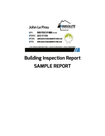
Barite Hill/Nevada GoldfieldsSCD 987 597 903Page 8Table 1: ContinuedTable 2: ContinuedAll results in ug/kgAll results in mg/kgAnalyteBH-004-SWTitanium50 UThallium5.0 UVanadium50 UYttrium190Zinc22000Total Mercury0.20 -SE47TitaniumThallium0.25 UVanadium26Yttrium0.74Zinc61Total sium35038000IronSodium200 UPotassium190Cyanide0.29 UJ"U" indicates analyte not detected at orabove reporting limit"J" indicates identification of analyte isacceptable, reported value is an estimate;"U" indicates analyte not detected at orabove reporting limit; "UJ" indicatesanalyte not detected at or above reportinglimit, reporting limit is an estimate.Plant Site and Process Area PondsThe plant area includes one metal building used to process water, a cinder block building usedfor offices and final gold extraction, a wood storage shed, 4 lined ponds, and 1 unlined pond.Leach/rinse solutions were routed from the leach pad by collection ditches to the pregnant pond.Water from the pregnant pond was fed to the processing plant. The gold and silver wereextracted from the water and the solution was emptied into the barren pond. Barren pond waterwas 'refreshed' with added cyanide and applied to the heap leach pile (Ref. 3, 9, 10, 14, 16, 17,20).Excess heap leach water from heavy rain events, etc., was collected in the rinse ponds. Thediluted water in the rinse ponds was moved to the barren pond. From the barren pond, the waterwould be 'refreshed' and once again applied to the heap leach pile (Ref. 9, 10, 14, 16, 17).
Barite Hill/Nevada GoldfieldsSCD 987 597 903Page 9
Barite Hill/Nevada GoldfieldsSCD 987 597 903Page 10Table 3Process Area Pond CapacitiesPondMaximum Pond Level (gallons)1.73 x lO67.11 x 1051.55 x 1057.22 xlO 5Pregnant PondRinse Pond 1Rinse Pond 2Barren PondFour surface water and two sediment samples were collected from the ponds in the Plant andProcess area. Sample BH-013 -SW/SE was collected from the larger of the two rinse ponds.Sample BH-014-SW was collected from the smaller, northern most rinse pond. Sample BH-015SW/SE was collected from the pregnant pond. Sample BH-016-SW was collected from thebarren pond (Ref. 21, 22).Table 4: Barite Hill/Nevada GoldfieldsProcess Pond Water SamplesAnalyzed for TAL Metals.All results in ug/kg (Ref. mTinStrontiumBH-013-SW10U15226.0 U1.2 U1410U4204801902.5 U2.5 U160SOU130BH-014-SW5.0 U2.5 U383.0 U1.2 U5.0 U5.0 U109.3162.5 U2.5 U5.0 U15U39BH-015-SW10U18246.0 U1.2 U1510U1004502402.5 U2.5 U20030 U110BH-016-SW10U12A206.0 U1.2 U10U10U943802002.5 U2.5 U90 A30 U110"J" indicates identification of analyte is acceptable, reported value is an estimate; "U" indicates analyte notdetected at or above reporting limit; "UJ" indicates analyte not detected at or above reporting limit, reportinglimit is an estimate.
Barite Hill/Nevada GoldfieldsSCD 987 597 903Page 11Table 4: ContinuedAll results in ug/kgBH-013-SW BH-014-SW BH-015-SW BH-016-SWAnalyteTitanium10U10U10U5.0 UThallium2.5 U2.5 U2.5 U2.5 UVanadium10U10U10 U5.0 UYttrium6.0 U3.0 U6.0 U6.0 UZinc20 U10U20 U20 UTotal Mercury0.20 U0.20 U0.20 U0.20 U100 U100 U100 UAluminium50 0.451.3Iron0.20 U0.20 U0.20 U0.3Sodium760 J77830 J760 JPotassium2.1171515Cyanide10 U9110U10U"J" indicates identification of analyte is acceptable, reported value is an estimate; "U" indicates analyte notdetected at or above reporting limit; "UJ" indicates analyte not detected at or above reporting limit, reportinglimit is an estimate.Table 5: Barite Hill/Nevada GoldfieldsProcess Pond Sediment SamplesAnalyzed for TAL Metals.All results in mg/kg (Ref. mTinStrontiumBH-013-SE I3H-015-SE77 AJ77 A140 A7.5 U2.3 U15 U15 U24000 A15U220 A100 A1.8 AJ280 A170A490 A2.8305100.25 U0.496.5175002.741201.161.0 U30"A" indicates analyte analyzed in replicate. Reported value is"average" of replicates; "J" indicates identification of analyte isacceptable, reported value is an estimate; "U" indicatesanalyte not detected at or above reporting limit; "UJ" indicatesanalyte not detected at or above reporting limit, reporting limitis an estimate.
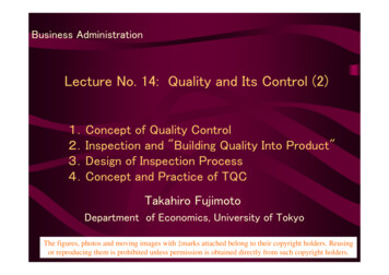
Barite Hill/Nevada GoldfieldsSCD 987 597 903Page 12Table 5: ContinuedAll results in mg/kgAnalyteBH-013-SE BH-015-SETitanium6248 AJThallium0.25 UJ0.25 UVanadium30 U27Yttrium3.215UZinc460 A52Total Mercury0.0671.86000 A4400AluminiumManganese110 AJ120220000 AJ5300 JCalciumMagnesium750 U38010000 AJ26000IronSodium6000 U200 UPotassium3000 U240Cyanide170010"A" indicates analyte analyzed in replicate. Reported value is"average" of replicates; "J" indicates identification of analyte isacceptable, reported value is an estimate; "U" indicatesanalyte not detected at or above reporting limit; "UJ" indicatesanalyte not detected at or above reporting limit, reporting limitis an estimate.Permanent Leach Pad PondsThe permanent leach pad area contains the permanent leach pad and three lined ponds.Leach/rinse solutions were routed from the permanent leach pad by collection ditches to thepregnant pond. Water from the pregnant pond was fed to the processing plant. The gold andsilver were extracted from the water and the solution was emptied into the barren pond. Barrenpond water was 'refreshed' with added cyanide and applied to the heap leach pile (Ref. 3, 9, 10,14,16,17,20).Excess heap leach water from heavy rain events, etc., was collected in the rinse ponds. Thediluted water in the rinse ponds was moved to the barren pond. From the barren pond, the waterwould be 'refreshed' and once again applied to the heap leach pile (Ref. 9, 10, 14, 16, 17).Table 6Permanent Leach Pad Area Pond CapacitiesPondPregnant PondRinse PondBarren PondMaximum Pond Level (gallons)1.50 xlO 61.00 xlO 66.86 xlO 6
Barite Hill/Nevada GoldfieldsSCD 987 597 903Page 13Three surface water samples and one sediment sample were collected from the ponds in the Plantand Process area. Sample BH-006-SW/SE was collected from the rinse pond. Sample BH-007SW was collected from the pregnant pond. Sample BH-008-SW was collected from the barrenpond (Ref. 21, 22).Table 7: Barite Hill/Nevada GoldfieldsPermanent Leach Pad Area Water SamplesAnalyzed for TAL Metals.All results in ug/kg Ref. 19AnalyteBH-006-SW BH-007-SW 5UBeryllium9.0 U9.0 U9.0 U2.7Cadmium2.81.2 0210026002100Molybdenum37Nickel40405.0 ULead2.5 U2.5 ntium400390420Titanium15U15U15UThallium2.5 U5.0 U2.5 UVanadium15U15U15UYttrium9.0 U9.0 U9.0 U32Zinc120130Total Mercury0.240.20 U0.20 U300 U150U300 ium5.65.760.420.30 UIron0.30 USodium1200 J1200 J1100 JPotassium302728Cyanide13004860 j "J" indicates identification of analyte is acceptable, reported value is an estimate; "Windicates analyte not detected at or above reporting limit; "UJ" indicates analyte notdetected at or above reporting limit, reporting limit is an estimate.
Table 8: Barite Hill/Nevada GoldfieldsPermanent Leach Pad Area Sediment SampleAnalyzed for TAL Metals.All results in cTotal mPotassiumCyanideBH-007-SE60160325.0 U6.819021 U20000290765.92.2170020 U289.9 U0.25 U20 U246202.8 A3600835400 J500 U850061002000 U260"A" indicates analyte analyzed in replicate.Reported value is "average" of replicates; "J"indicates identification of analyte is acceptable,reported value is an estimate; "U" indicates analytenot detected at or above reporting limit; "UJ"indicates analyte not detected at or above reportinglimit, reporting limit is an estimate.
Barite Hill/Nevada GoldfieldsSCD 987 597 903Page 15Mineralized ZoneThe Mineralized Zone refers to a 22-acre crusher/reusable pad area located roughly in the centerof the site to the southeast of the Process Area. The crusher/reusable pad area was reclaimed inmid 1995. Periodic monitoring of stormwater runoff at NPDES Outfall 1 between 1995 and1998 exhibited a depressed pH and elevated metal concentrations due to contact with sulfidebearing soil and rock material (Ref 3, 14, 23, 24).The crusher area consisted of a crusher and agglomeration system that processed both oxide andsulfide ores mined from the Main and Rainsford Pits. Run-of-mine ore from a nearby stockpilewas fed into the crasher where it was reduced to a minus one-inch size and then mixed withcement to produce a product suitable for leaching. The agglomerated ore was stacked on theleach pad using a rubber-tired conveyor system (Ref. 10, 12, 16, 17, 23).The reusable leach pad covered approximately 7-acres and consisted of an asphalt-lined padsurrounded by asphalt berms. Agglomerated ore was stacked on the pad to a height ofapproximately 30 feet and was leached with a cyanide solution in a closed-circuit process torecover gold and silver values. After leaching, the ore was rinsed with water and transported tothe clay-lined Area C Landfill for disposal (Ref. 3, 10, 12, 16, 17, 23).Reclamation included the excavation of the asphalt liner, which was placed in the permanentleach pad. The area was harrowed and reseeded (Ref. 23).During SCDHEC's visits to the site on December 8, 2003 and September 26, 2004 sulfidebearing soils and rock material were visibly exposed in the Mineralized Zone. Vegetative coverwas poor to nonexistent (Ref. 22).The Mineralized Zone was screened with an Innov-X Systems XL-440 portable XRF during theSeptember 26, 2004 Sampling event. Based on the screening results the locations of three soilsamples were determined (Ref. 21, 22).
Barite Hill/Nevada GoldfieldsSCD 987 597 903Page 16Table 9: Barite Hill/Nevada Goldfields Mineralized Zone SoilSamples. Analyzed for TAL Metals. All results in mg/kg (Ref. 19)AnalyteBH-019-SO I3H-020-SO BH-021-SOSilver1.5A0.681.356Arsenic39 AJ5.3Barium8601100870 AJBeryllium0.60 U0.30 U0.30 UCadmium0.12 U0.430.12 U1.0 UCobalt2.6 AJ1.3Chromium8.9 A5.76.6Copper96 AJ782300.80 AJ1.0 U0.50 UMolybdenumNickel2.0 U1.0 U2.0 ULead200 A28801Antimony1.4 AJ0.25 U11.3AJ1.3SeleniumTin3.0 U1.5 U1.5UStrontium9.38.3 A9.7Titanium55 A3755Thallium0.25 U0.25 U0.25 U24Vanadium33 A31Yttrium0.46 A0.780.6712A23Zinc16Total Mercury0.140.098 U0.098 U24003300 A3100Aluminium27 U92 AJ32ManganeseCalcium530 AJ180J59 JMagnesium490 AJ50 U20031000 AJ23000 J3200 JIronSodium200 U100 U220Potassium180 A200 U1500.43UJCyanide0.16 UJ43"A" indicates analyte analyzed in replicate. Reported value is "average" of replicates; "J"indicates identification of analyte is acceptable, reported value is an estimate; "U" indicatesanalyte not detected at or above reporting limit; "UJ" indicates analyte not detected at orabove reporting limit, reporting limit is an estimate.
Barite Hill/Nevada GoldfieldsSCD 987 597 903Page 17VI.GROUNDWATERThe Barite Hill/Nevada Goldfields site is located approximately 3 miles south of McCormick inMcCormick County. The majority of the population within a 4-mile radius of the site is providedpotable water by McCormick County Water and Sewer. McCormick County Water and Sewerobtains water from Strom Thurmond Lake near the Hawes Creek discharge point. McCormickCounty Water and Sewer serves approximately 4,000 taps (Ref. 3, 9, 25).Three zones of groundwater have been identified underlying the site. The zones are hydraulicallyconnected; therefore, no isolated or perched water table conditions are expected to exist below thesite. The first and upper zone exists within the saprolitic materials (extremely degraded andweathered bedrock and colluvial soils with bedrock-like structures and fractures. The second zone iswithin the fracture system of the underlying weathered bedrock. The third zone is within thecompetent bedrock designated as the Igneous and Metamorphic Bedrock Aquifer System (Ref. 25,26).All three zones exhibit similar horizontal gradients in a southerly direction consistent with the reliefof the topographic expression. The hydraulic conductivity from one zone to the next is relativelydifferent and is a function of the material. The average hydraulic conductivity as measured in thefield within the saprolitic material is about 0.05 ft/day (Ref. 25, 26).Based on field observations (DP Engineering et al. 1990), the hydraulic conductivity of the upperportion of the saprolitic material and colluvial clay soil covering the site maybe as much as one ortwo orders of magnitude lower. This is because the secondary features of the lower saproliticmaterial (i.e., fractures, joints and bedding planes) that control hydraulic conductivity are lessprominent or nonexistent near surface materials. Therefore, hydraulic conductivity is controlledprimarily flow patterns (i.e., through the pore structure of the material) rather then the 'open'structures. Due to fine-grained particle size and clayey consistency of the surface materials, thehydraulic conductivity would be lower in areas where the material has been compacted (Ref. 12,25,26).The middle zone (weathered rock) has an average hydraulic conductivity of 0.18 ft/day. Thisincreased value is probably a result of more open fracture and joint patterns in the bedrock. Themore 'open' secondary fractures are likely the result of oxidation and leaching out of joint andfracture fillers and relief of confining pressures in the near surface rock (Ref. 12, 25, 26).The lower zone of competent bedrock exhibited a conductivity of 0.019 ft/day and 0.09 ft/day in thetwo boreholes used in the field tests (Ref. 12, 25, 26).The vertical gradient in the lower groundwater zone is upward to the intermediate zone. The upperbedrock zone or intermediate groundwater zone exhibits a higher hydraulic conductivity than thesaprolitic material, thus acting as a receptor and interrupting the upward gradient to the surface. In
Barite Hill/Nevada GoldfieldsSCD 987 597 903Page 18turn, the gradient from the saprolitic material to the upper bedrock is downward (Ref. 12, 25, 26).There has been previous environmental sampling and groundwater monitoring at the site. Nosignificant detections of elevated metals or hazardous substances have been reported. Because ofthe remoteness of the site, and the lack of wells used for drinking water, no groundwater sampleswere taken for the SI investigation (Ref. 3, 21, 24).VI.SURFACE WATER PATHWAYA. Regional CharacteristicsStrom Thurmond Lake on the Savannah River is approximately 3 miles down gradient of the site.The most significant surface drainages at the mine site are two tributaries to Hawe Creek. Oneperennial tributary runs approximately 4,000 feet along the north side of the mine site. The secondtributary, which appears to be ephemeral, starts on the south side of the site and drains to the west forapproximately 2,000 feet before turning northward and flowing another 3,000 feet along the westside the mine site. The confluence of the two tributaries is about 200 feet northwest of the overallproperty boundaries. From here, the unnamed tributary flows about 800 feet into Hawe Creek.Hawe Creek runs about 3 river-miles before emptying into Strom Thurmond Lake on the SavannahRiver. The Savannah River completes the 15-mile Target Distance Limit (TDL) (Ref. 3, 9, 12,14).The Barite Hill/Nevada Goldfields site operated two outfalls to nearby surface water under NPDESPermit No. SC0043401. The primary effluent was surface water runoff from the site, including minedrainage from rinsed ore bodies. The Barite Hill/Nevada Goldfields site exceeded the water qualitystandards set in NPDES Permit No. SC0043401 numerous times as detailed in SCDHEC NOV 8-2595,6-27-96, 10-30-1996, and 3-11-1997 (Ref. 14, 24).The site was abandoned in the summer of 1999. No surface water run-on o
Nevada Goldfields filed for Chapter 7 Bankruptcy in 1999, the reclamation of the site was being addressed by Nevada Goldfields. On July 7, 1999 Nevada Goldfields handed the facility's keys to SCDHEC and abandoned the site. The site is located along a topographic high ridge area forming the headwaters of an unnamed tributary to Hawes Creek.