Transcription
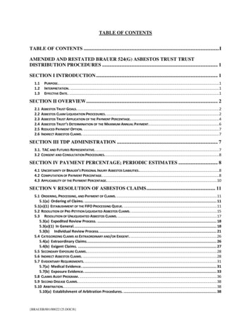
Electronic Files – Table of ContentsDescription of file contents . Volunteer Remediation Program Progress Report 31. Certification .Conyers VRP Project GeologistGeorgia Environmental Protection Division Document Submittal Form2. Main Document .Volunteer Remediation Program Progress Report 33. Tables .Groundwater Level Measurements . Table 1Summary of Groundwater Analytical Results . Table 24. Figures.Site Location Map . Figure 1Site Map Groundwater Well Locations . Figure 2Groundwater Elevation Potentiometric Surface Map March 2017 . Figure 3Groundwater TCE/PCE Analytical Results March 2017 with TCE ConcentrationIsopleths . Figure 4Groundwater Lead Analytical Results March 2017 with Approximate Lead ConcentrationIsopleths . Figure 5Apparent Top of Shallow Bedrock Elevations Contour Map . Figure 6Concentrations Cross Section A-A’ . Figure 7Concentrations Cross Section B-B’ . Figure 85. Appendices .Groundwater Sample Collection Field Sheets .Appendix ALaboratory Analytical Reports and Chain-of-Custody Documentation. Appendix BData Review and Validation Report . Appendix CGantt Chart .Appendix D
Submitted toC&D Technologies1400 Union Meeting RoadBlue Bell, Pennsylvania 19422Submitted byAECOM1000 CorporateCentre Dr., Ste. 250Franklin, TN 37067October 2017Volunteer Remediation ProgramProgress Report 3C&D Technologies, Inc.Conyers, Rockdale County, GeorgiaC&D Technologies, Inc.1835 Rockdale Industrial Blvd.Conyers, GeorgiaFooterDate/Year
iAbout AECContents1.0 Introduction. 1-12.0 Site Background . 2-22.1Historic Activities . 2-22.2Site Geology and Hydrogeology . 2-33.0 Semiannual Groundwater Monitoring . 3-13.1March 2017 Semiannual Groundwater Monitoring Event . 3-13.1.1Groundwater Gauging and Sampling Protocol . 3-13.1.2Groundwater Sample Handling . 3-23.1.3Ancillary Field Activities . 3-23.2Groundwater Flow Direction . 3-23.3Analytical Results. 3-24.0 Summary and Future Groundwater Monitoring . 4-4October 201760530734
iiList of TablesTable 1 – Groundwater Elevation DataTable 2 – Summary of Groundwater Analytical ResultsList of FiguresFigure 1 – Site Location MapFigure 2 – Site Map Groundwater Well LocationsFigure 3 – Groundwater Elevation Potentiometric Surface Map March 2017Figure 4 – Groundwater TCE/PCE Analytical Results September with TCE Concentration IsoplethsFigure 5 – Groundwater TCE/PCE Analytical Results September with Lead Concentration IsoplethsFigure 6 – Apparent Top of Shallow Bedrock Elevations Contour MapFigure 7 – Concentrations Cross Section A-A’Figure 8 – Concentrations Cross Section B-B’List of AppendicesAppendix A – Groundwater Sample Collection Field SheetsAppendix B – Laboratory Analytical Reports and Chain-of-Custody DocumentationAppendix C – Data Review and Validation ReportAppendix D – Gantt ChartOctober 201760530734
iiiCERTIFICATIONVolunteer Remediation Program Progress Report 3C&D Technologies, 1835 Rockdale Industrial Blvd, Conyers, GeorgiaOctober 2017HSI#10734PREPARED FORC&D Technologies1400 Union Meeting RoadBlue Bell, Pennsylvania 19422-0858I certify that I am a qualified groundwater scientist who has received a baccalaureate or post-graduatedegree in the natural sciences or engineering, and have sufficient training and experience ingroundwater hydrogeology and related fields, as demonstrated by state registration and completion ofaccredited university courses, that enabled me to make sound professional judgments regardinggroundwater monitoring and contaminant fate and transport. I further certify that this report wasprepared by myself or by a subordinate working under my direction.State of Georgia Professional Geologist No. 1966SignatureDateCraig A. Bernhoft, P.G.AECOMOctober 201760530734
AECOM1.0Environment1-1IntroductionThe C&D Technologies, Inc. (C&D) site is located at 1835 Rockdale Industrial Boulevard in Conyers,Rockdale County, Georgia (the site) (see Figure 1). The C&D Facility has been listed on the GeorgiaHazardous Site Inventory (HSI) Number 10734 as a facility that has a known release in groundwaterat levels exceeding the reportable quantity. Chlorinated volatile organic compounds (VOCs)trichloroethene (TCE), tetrachloroethene (PCE), cis-1,2-dichloroethene (cis-DCE), and lead havebeen detected in groundwater samples at concentrations exceeding the Georgia Hazardous SiteResponse Act (HSRA) Type 1/3 Risk Reduction Standards (RRS). C&D has performed groundwaterremediation activities at the Facility since 2006.C&D submitted a Voluntary Remediation Program (VRP) application in September 2015 to theGeorgia Environmental Protection Division (GA EPD) that was approved by the GA EPD letter datedDecember 23, 2015. The first semi-annual progress report was submitted to the GA EPD in June2016. This report summarizes the field activities and findings of the third semi-annual groundwatermonitoring event conducted in March 2017.October 201760530734
AECOM2.0Environment2-2Site BackgroundC&D previously manufactured lead-acid batteries for over 35 years at the site. Manufacturingoperations ceased in 2007. Located on 8.27acres in a commercial/industrial area, the C&D Facility isno longer active and the former manufacturing buildings have been razed. A site map of the Facilityand nearby properties is presented on Figure 2.2.1Historic ActivitiesC&D has conducted several assessments of impacted groundwater at the site. Previous groundwatersampling data indicate that TCE and PCE concentrations exceeding the Georgia HSRA Type 1/3RRS (5 µg/L) extend north and northeast in the apparent direction of the groundwater flow from thehigh concentration area (MW-5) located on the C&D Facility onto the central portions of the Pattilloand Latex Properties. Analytical data of groundwater samples collected from monitoring wellsinstalled along the east and northeastern Pattillo Property boundary indicate TCE and PCEconcentrations below the Type 1/3 RRS. TCE concentrations in groundwater samples collected fromthe northernmost monitoring well installed on the Pattillo Property were slightly above the Type 1/3RRS. PCE concentrations from this same location are below the Type 1/3 RRS.Based upon a groundwater remediation design prepared by RMT (2006), chemical additives wereinjected into groundwater to elevate pH, promote lead precipitation, and support reductivedechlorination within the source area as well as support enhanced natural degradation processeswithin the downgradient plume. Results of the pilot testing indicated that while the bioremediationand/or enhanced natural degradation processes could be accelerated in the downgradient plume(INJ-2), subsurface distribution challenges in the source area required additional testing.In 2007, monitoring wells were installed on the Robert Pattillo Property by Dobbs Environmental thatindicated groundwater beneath the Pattillo Property may have been impacted by TCE and PCE.Additional groundwater investigation sampling in October 2008 indicate PCE-, TCE-, and/or cis-DCEimpacted groundwater is present in the overburden and the shallow bedrock, but not present in thedeep monitoring well (MW-14, 100 feet bgs) located within the plume.Groundwater delineation activities completed in 2009 and 2010 included installing and samplingadditional monitoring wells on the C&D property, and the Pattillo, Pittman Construction, Latex, andFrey-Moss Structures (FMS) Properties (Figure 2). These investigation activities focused primarily onthe source area, currently defined as MW-5 and MW-5D.A Phase I in-situ chemical reduction (ISCR) field-scale injection event on the source area wasconducted in late January 2012. Performance monitoring events were conducted and the findingsindicated the ISCR influenced some portions of the treatment zone although full scale application bydirect injection in the source zone would not be effective due to geochemical complexities and difficultlithology. The difficulty of injecting via rotary drilling and/or direct push drilling suggests source-zonetreatment similar to the ISCR injection is not a technically feasible approach.The status was further discussed in a project status review meeting held at GAEPD on June 29,2015. During the meeting it was agreed that the application should be submitted based on thesubsurface conditions and potential technical impracticability of achieving the HSRA Type 1/3October 201760530734
AECOMEnvironment2-3RRS. The C&D facility was accepted into the Georgia VRP in December 2015. The initial semiannual groundwater event was completed in February and March 2016. Results of the semiannual groundwater event indicated: TCE concentrations detected in some of the groundwater samples collected from the C&DFacility and Pattillo and Latex Properties were above the Georgia HSRA Type 1/3 RRS of 5µg/L; PCE exceeded the Type 1/3 RRS of 5 ug/L on the C&D Facility, Pittman, and Frey-Mossproperties; Lead concentrations exceeding the Type 1/3 RRS (0.015 mg/L) were detected in 5 of thewells sampled (CD-01, MW-5, MW-5D, MW-19, MW-20); TCE and PCE concentrations decreased in the source area (MW-5 and MW-5D) sincesampling events conducted prior to 2016; however, concentrations of TCE and PCEincreased slightly in down gradient monitoring wells on the Latex property; and The concentration isopleth boundary decreased along the eastern perimeter wells on thePattillo Property.AECOM proposed collecting groundwater samples from select wells for the 2017 semi-annualsampling event. Wells located within the highest TCE concentration area (CD-01, MW-2, MW-3, MW5, MW-5D, MW-8 SBR, MW-17, MW-19, MW-20, MW-24 SBR, MW-29 SBR, MW-30 SBR, MW-36,MW-37, MW-38 SBR, OBS-8) and off-site wells (MW-11, MW-11D, MW-16 and MW-27 SBR) wereselected for sampling. The semi-annual event was completed in March 2017.2.2Site Geology and HydrogeologyThe site is located in the Piedmont physiographic province. The Facility is underlain by granite plutonsand other metamorphic and igneous rocks that have been subject to geologic erosion and generallyare deeply weathered. The weathering has resulted in a relatively thick layer of saprolite(unconsolidated, weathered rock) and soil beneath the ground surface. The area around the subjectproperty is underlain by undifferentiated granitic gneiss. The depth to competent bedrock varies fromless than one foot near the main former manufacturing building to greater than 90 feet to the north ofthe Facility.Groundwater beneath the Facility is shallow, ranging from approximately 10 to 40 feet below groundsurface (bgs) (Table 1), and predominantly flows to the north-northeast (Figure 3). Shallowgroundwater occurs in an unconfined aquifer made up of potentially interconnected water bearingzones: a shallow zone of soil and weathered rock, and a deeper zone of fractured bedrock. Thesefractures contribute to the complexities of groundwater flow in the area.Slug tests indicate that the hydraulic conductivity of the shallow water bearing unit varies between10-3 and 10-5 cm/sec. The groundwater flow direction from the impacted suspected source area isgenerally to the north and northeast with a hydraulic gradient of 0.025 ft/ft (S&ME, 2008). A mapshowing the groundwater potentiometric surface contours and flow direction based upongroundwater elevations for the shallow aquifer during the March 2017 groundwater samplingevent is included as Figure 3.October 201760530734
AECOMEnvironment2-4Aquifer tests have indicated that the shallow regolith and bedrock zones are hydraulicallyseparated in the Conyers area based on the lack of interconnectivity of the deep bedrock systemto the shallow water-table zone in the weathered regolith.October 201760530734
AECOM3.0Environment3-1Semiannual Groundwater MonitoringFor the groundwater monitoring event 20 of the existing site-wide wells were targeted forgroundwater sample collection. The sampling methodology and results for the sampling event arepresented in the following subsections.3.1March 2017 Semiannual Groundwater Monitoring EventGroundwater samples were collected on March 28 through March 30, 2017 from the groundwaterwells located on the C&D property and surrounding properties (C&D-01, MW-2, MW-3, MW-5, MW5D, MW-8 SBR, MW-11, MW-11D, MW-16, MW-17, MW-19, MW-20, MW-24 SBR, MW-27 SBR,MW-29 SBR, MW-30 SBR, MW-36 SBR, MW-37 SBR, MW-38 SBR, and OBS-8). The groundwatermonitoring well locations are depicted on Figure 2. The collected groundwater samples from thewells were analyzed for VOCs using United States Environmental Protection Agency (US EPA)Method 8260B and/or lead using US EPA Method 6020A. One duplicate sample was collected forquality assurance and quality control (QA/QC). Two matrix spike/matrix spike duplicates were alsocollected for QA/QC purposes. A trip blank was provided by the laboratory.3.1.1 Groundwater Gauging and Sampling ProtocolMonitoring wells were gauged and sampled in general accordance with the US EPA Region 4 FieldBranches Quality System and Technical (FBQST) Procedures. Each monitoring well was openedand allowed to equilibrate. Groundwater level measurements were recorded using an electronicwater level indicator. Groundwater levels were recorded to the nearest 0.01 ft as measured from thewater table to the well’s top of casing (TOC). The depth to water was subtracted from the knownTOC elevation (ft mean sea level) to calculate the groundwater elevation at each well location forpotentiometric purposes.AECOM was not able to collect groundwater level measurements from monitoring wells MW-1, MW13, and C&D-02. Monitoring well MW-1 could not be located. It is believed MW-1 may have beendamaged during construction work that has been completed in the area. Monitoring well MW-13 islocated off site on property owned by a private resident. No one was available at the residenceduring the sampling to allow access. Consistent with the September 2016 groundwater samplingevent, monitoring well C&D-02 could not be located.With the exception of MW-17, groundwater samples were collected from monitoring wells C&D-01,MW-2, MW-3, MW-5, MW-5D, MW-8 SBR, MW-11, MW-11D, MW-16, MW-19, MW-20, MW-24,MW-27 SBR, MW-29 SBR, MW-30, MW-36 SBR, MW-37 SBR, MW-38 SBR, and observation wellOBS-8 using a peristaltic pump equipped with dedicated Teflon-line tubing. A stainless steel bladderpump equipped with a disposable Teflon bladder and dedicated Teflon-lined low density polyethylenetubing was used to collect groundwater samples from MW-17. During purging and sampling, thebladder pump was placed in the middle of the screened interval. Each monitoring well was purgedand sampled using the low flow/low purge method as outlined in Section 3.2.1 of the US EPA Region4 Science and Ecosystem Support Division (SESD) Groundwater Sampling Operating Proceduredated April 26, 2017. For locations where the peristaltic pump was used for collection of groundwatersamples for VOC analysis, a reverse-flow technique was used for sample collection. For welllocations with slow recharge (i.e., 3 to 5 volume purge method and the low flow/low purge methodOctober 201760530734
AECOMEnvironment3-2cannot be completed), the well was purged dry and a groundwater sample was collected as soon asthere was enough recharge water to collect a sample.Water quality parameters including temperature, pH, conductivity, oxidation-reduction potential(ORP), dissolved oxygen (DO), and turbidity were recorded during groundwater purging activities.The water quality parameters were recorded in the field using a YSI Pro water quality meter equippedwith a flow through cell and recorded on the groundwater sampling logs at each monitoring welllocation. Water quality measurements were recorded at 5-minute intervals until the parametersstabilized. Samples were collected in accordance with USEPA SESD parameter stabilization criteria,when, for at least three consecutive measurements, the pH remained constant within 0.1 StandardUnit (SU), specific conductance varied no more than 5 percent, dissolved oxygen (DO) was below0.2 mg/L or 10% change in saturation, and turbidity stabilized or was 10 nephelometric turbidity units(NTUs). Upon stabilization, groundwater samples were transferred to the appropriate laboratorysupplied sample containers. Refer to Appendix A for the groundwater sampling field logs.3.1.2 Groundwater Sample HandlingGroundwater samples were collected in new, laboratory supplied, pre-preserved 40-milliliter glassvials and/or 250-milliliter polyethylene containers. The sample containers for each well were handledusing new, disposable Nitrile gloves. Groundwater samples were labeled and placed on wet ice ingeneral accordance with chain-of-custody protocol prior to being picked up by a Test AmericaLaboratory (TA) courier. The TA courier subsequently packaged and shipped the groundwatersamples to TA’s Nashville, Tennessee location for chemical analysis.3.1.3 Ancillary Field ActivitiesFollowing sampling, purge water was contained in two steel 55-gallon drums, sampled for wastecharacterization and disposed. Sampling equipment including the electronic water level meters weredecontaminated prior to initial use and after being used at each well with a Liquinox and distilledwater mixture and a distilled water rinse.3.2Groundwater Flow DirectionDepth to groundwater was measured during the March 2017 monitoring event as described inSection 3.1.3. The measurements w
Appendix D – Gantt Chart . iii October 2017 60530734 CERTIFICATION Volunteer Remediation Program Progress Report 3 . Facility and Pattillo and Latex Properties were above the Georgia HSRA Type 1/3 RR