Transcription
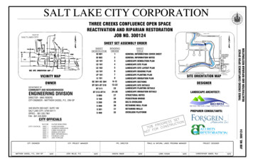
THREE CREEKS CONFLUENCE OPEN SPACEREACTIVATION AND RIPARIAN RESTORATIONJOB NO. 300124 VICINITY MAPOWNERDEPARTMENT OF:COMMUNITY AND NEIGHBORHOODSENGINEERING DIVISIONDIRECTOR - MIKE REBERGCITY ENGINEER - MATTHEW CASSEL, P.E., ENV-SP349 SOUTH 200 EAST, SUITE 100SALT LAKE CITY, UTAH 84111OFFICE - 801.535.7961FAX - 801.535.6093FREMONT AVENUE GI 001GI 002LD 101LS 101LS 102LG 101LP 101LI 101SC 301-SC 304DT 501-DT 510DT 511DT 512-DT14S 000S 100S 200S 300S 301S 400 123456789-1213-222324-26272829303132 GENERAL INFORMATION COVER SHEETGENERAL INFORMATION NOTESLANDSCAPE DEMOLITION PLANLANDSCAPE SITE PLANLANDSCAPE SITE LAYOUT PLANLANDSCAPE GRADING PLANLANDSCAPE PLANTING PLANLANDSCAPE IRRIGATION PLANLANDSCAPE SECTIONSLANDSCAPE SITE DETAILSLANDSCAPE PLANTING DETAILSLANDSCAPE IRRIGATION DETAILSSTRUCTURAL NOTESPEDESTRIAN BRIDGEDELTA OVERLOOKRETAINING WALL PLANRETAINING WALLSOVERLOOK PLATFORM BEND IN THE RIVER PARKSHEET SET ASSEMBLY ORDERJORDANRIVERMODESTO PARKMODESTO AVENUELUCY AVENUEPROJECTAREA13THSOUTHTRAILHEADA NR DJ ORV ER IPENNYWISEMART1300 SOUTHV&LAUTOSERVICESCALIFORNIA AVENUESITE ORIENTATION MAPSLCAP LANDSCAPE ARCHITECT:THREE CREEKS CONFLUENCE OPEN SPACEREACTIVATION AND RIPARIAN RESTORATION900 WEST 1300 SOUTH JORDAN PARK900 WEST PREPARER CONSULTANTS: JOB NO. 300124CITY OFFICIALS
GENERAL NOTESSite MappingBasis of bearing for plans is Utah State Plane Central Zone NAD' 83 US Survey footCoordinates. Elevation datum is NAVD 88/Geoid model 1999. The base survey was provided bySalt Lake City Corporation. Verification of survey mapping is the responsibility of the Contractor.Survey StakingSurvey staking is the responsibility of the Contractor. The Contractor may obtain CAD files fromthe Designer for staking and layout purposes.PermitsThe Contractor is required to comply with all construction related requirements in each permitissued for the project.UtilitiesThe Contractor is responsible for locating and avoiding all utilities and service laterals, and forrepairing all damage that occurs to the utilities due to the Contractor's activities. It is theresponsibility of the Contractor to perform all utility locations at least 48 hours prior to excavation,call 1(800)662-4111. It is the responsibility of the Contractor to protect all existing sewer, water,gas and electric utilities encountered in the work. Any relocation or improvements of utilitiesshall be accurately noted on as-built drawings and issued to the Owners Representative at thecompletion of the project. Existing utility information obtained from Public Utilities' maps must beassumed as approximate and requiring field verification. Contact blue stakes or appropriateowner for communication line locations.Utility RelocationsFor utility conflicts requiring relocations, the contractor must notify the applicable utility companyor user a minimum of 2-weeks in advance. A one-week minimum notification is required forconflicts requiring the relocation of service laterals. All relocations are subject to approval fromthe applicable utility company and/or user.SafetyThe Contractor is responsible for all aspects of safety of the project and shall meet all OSHA,State, County and other governing entity requirements. The Contractor is solely responsible forconforming to local and Federal codes governing shoring and bracing of excavations andtrenches, and for the protection of workers.Traffic Control and Haul RoutesTraffic control must conform to the most current edition of Salt Lake City Traffic Control Manual Part 6 of “Manual On Uniform Traffic Control Devices” for Salt Lake County and state roads. SLCTransportation must approve all project haul routes (535-7129). The Contractor must alsoconform to UDOT, Salt Lake County or other applicable governing entities requirements fortraffic control.Temporary Construction FacilitiesAll temporary utilities and facilities will be the responsibility of the Contractor. A constructiontrailer is not required. Potable water is not available on site and shall be provided by theContractor. A chemical toilet of suitable type shall be provided and maintained by the Contractorat all times. The Contractor is responsible for job site conditions and the safety for human lifeduring the course of construction. This requirement shall apply continuously during the period ofconstruction and is not limited to normal working hours.The Contractor shall keep job site area clean, hazard free and dispose of all debris, rubbish andconstruction waste, and remove all abandoned materials from the site. All disturbed staging andaccess areas are to be restored to pre-construction condition. The Contractor is responsible toreclaim (regrade, seed and mulch, replace trees and shrubs or turf sod) construction features notspecified as remaining on the site and clean up all areas at the completion of the project.Construction Spoils and Waste HandlingItems encountered below grade and not shown on the drawings shall be brought to the attentionof the Owners Representative. All construction spoils and waste are the responsibility of theContractor and shall be disposed of at an approved landfill facility.Clearing and GrubbingExisting on-site materials shall be carefully removed and stored for re-use, or disposed of at anapproved landfill facility. All existing vegetation not in designated excavation areas and notdesignated for removal is to be protected in place. Completely remove stumps, roots, shrubs,weeds, and other debris protruding from the ground in areas to be excavated.Site Earthwork and GradingThe Contractor is responsible for all site earthwork and grading activities to meet designsidentified in plans and details, which are intended to show final result of design. Modificationsmay be required to suit job site conditions encountered during construction and shall be includedin as-built drawings provided to the Owners Representative at completion of the project.All river channel banks and stream channel banks affected by construction activities shall bestabilized and protected throughout construction.Backfill and embankment material shall be composed of suitable excavated soils.Existing topsoil shall be excavated and salvaged by Contractor for use in landscaping andgrading activities. Topsoils used in landscaping shall have acidity range (pH) from 5.5 to 7.5 anda minimum organic content of 2%.Topsoil shall be placed at 80% to 90% maximum dry density and subsoil at 85% minimumcompaction as determined by the Standard Proctor Method (ASTM D0698-66T or AASHTOT99). All existing topsoils shall be salvaged and utilized for revegetation activities to the extentpossible.Site Construction NotesAll tree removal activities and site disturbance activities between April 1 and Augutst 31shalloccur only after a Nesting Bird Survey has been conducted within the construction site footprintand all protocols and protective measures are followed.All planting and seeding activities shall occur during the designated seeding and planting windowfrom September 15 to December 1 unless in areas with irrigation or as otherwise authorized bythe Owners Representative.Where ground conditions are damp and equipment traffic would result in excessive groundcompaction and rutting, use construction mats to access active work areas.Use a water truck or other suitable watering device as needed to control dust.Inspect paved roads adjacent to the project site regularly for mud tracking; sweep roadways asneeded and ensure roads are left clean at the end of each shift.Clean site and dispose of construction waste as permitted.Temporary Environmental/Safety FenceInstall fencing to demarcate active work areas as appropriate based on construction phasing.The Contractor is responsible to keep access to Private Property open at all times duringconstruction. The Contractor is responsible to keep access to areas of the park not affected byconstruction open at all times during WSFSHTTCTWTYPVERTAPPROXIMATEAVERAGEBOTTOM OF CURBBENCHMARKBACK OF CURBBOTTOM OF WALLCALIPERCENTERLINECUBIC YARDDIAMETERELEVATIONEXISTINGFINISH GRADEHORIZONTALHIGH POINTINCHESLINEAR FEETLOW POINTMAXIMUMMINIMUMMISCELLANEOUSNOT IN CONTRACTNUMBERNOT TO SCALEON CENTERREQUIREDRIGHT OF WAYSQUARE FOOTSHEETTOP OF CURBTOP OF WALLTYPICALVERTICALTHREE CREEKSCONFLUENCE OPENSPACEREACTIVATION ANDRIPARIANRESTORATIONThe Contractor is responsible for installing water control measures as needed to perform streamwork in dry conditions. Water control measures include but are not limited to diversions, culverts,sumps with pumps or other means necessary to divert surface water away from the active workarea. Adequate measures must be taken to remove all sediment prior to discharge .Storm Water Pollution Prevention Plan Notes1. No earth shall be disturbed until all erosion control measures are in place.2. Erosion control measures will be maintained and remain in place until re-vegetation measureshave been established.SALT LAKE CITYCORPORATIONSITE ORIENTATION KEYENGINEERINGJORDAN PARK3. Monitor, inspect, and maintain all erosion control measures as needed to prevent erosion andsediment discharge into creeks or pond. Adjust locations of measures and install additionalmeasures as construction phasing requires. Disturbed areas where construction activity hasceased will be stabilized in accordance with State UPDES and Salt Lake City requirements.Submittal of NOI and acquisition of UPDES Storm Water General Permit for ConstructionActivities (UTR300000) is the responsibility of the Contractor.FREMONT AVENUEBEND IN THE RIVER PARKJ O R D A N4. The Contractor is responsible for implementing and utilizing Best Management Practices(BMPs) to prevent storm water runoff and water pollution during construction activities. TheContractor is responsible for supplying equipment and plans that provide both dust and firecontrol during project construction. Use caution when working in and around wet areas. Ifpotential hazardous materials are encountered, contact the Owners Representative immediately.R I V E RMODESTOPARKMODESTO AVENUE900 WESTProject LimitsAll construction activity shall be confined to the project limit of disturbance including anystaging/stockpile areas. Do not disturb, excavate or work beyond project limits of disturbancewithout permission from the Owners Representative.Grading And Drainage Plan Notes1. Contractor to stake the boundary of the grading area for approval from the OwnersRepresentative prior to initiating grading activities.2. Contractor is responsible for erosion, dust and temporary drainage control during gradingoperations.3. Fill areas are to be compacted throughout to a minimum of 90% relative compaction.4. Contractor is responsible for the location and protection of all utilities.5. Export soil, if any, must be transported to a legal landfill or permitted site.LUCY AVENUEPROJECTAREA13TH SOUTHTRAILHEADA NRDJ ORV ER IPENNYWISEMART1300 SOUTHV&LAUTOSERVICESSLCAPHEADSTARTCALIFORNIA ONNOTESGI 002
LANDSCAPE DEMOLITION PLAN NOTES1. LOCATE AND VERIFY ALL UTILITY LINE LOCATIONS PRIOR TO DEMOLTION ANDREPORT ANY CONFLICTS TO THE OWNERS REPRESENTATIVE.2. CONSTRUCTION SITES MUST BE IN COMPLIANCE WITH THE UTAH POLLUTIONDISCHARGE ELIMINATION SYSTEM (UPDES) STORM WATER PERMIT FORCONSTRUCTION ACTIVITIES (538-6923). A COPY OF THE PERMIT'S STORM WATERPOLLUTION PREVENTION PLAN MUST BE SUBMITTED TO PUBLIC UTILITIES FORREVIEW AND APPROVAL. ADDITIONAL WATER QUALITY AND EROSION CONTROLMEASURES MAY BE REQUIRED. THE CONTRACTOR MUST ALSO COMPLY WITHSALT LAKE CITY'S CLEAN WHEEL ORDINANCE.WATER SURFACESHOWN AT 4222.8PRE-CONSTRUCTIONTHREE CREEKSCONFLUENCE OPENSPACEREACTIVATION ANDRIPARIANRESTORATIONSALT LAKE CITYCORPORATIONENGINEERINGLANDSCAPE DEMOLITION PLAN LEGENDPROJECT LIMIT LINEEXISTING COMMUNICATIONS PEDESTALEXISTING STORM SEWER MANHOLEEXISTING STORM MANHOLEEXISTING FIBER OPTICSEXISTING WATER VALVEEXISTING TREES - RETAIN AND PROTECTUNLESS OTHERWISE NOTEDLANDSCAPEDEMOLITION PLANEXISTING CONTOURREMOVE EXISTING FENCE (775 LINEAR FEET)REMOVE EXISTING CONCRETE BOX CULVERT (165 LINEAR FEET)REMOVE EXISTING 60 INCH DIA. RCP CULVERT (165 LINEAR FEET)040LD 10180Feet
LANDSCAPE SITE PLAN NOTES1. LOCATE AND VERIFY ALL UTILITY LINE LOCATIONS PRIOR TO CONSTRUCTIONAND REPORT ANY CONFLICTS TO THE OWNERS REPRESENTATIVE.BBOULDER BANKLINEDT505CDECORATIVE METAL FENCETYPE C CONCRETE CURB AND GUTTERDT505LIMESTONE CRUSHER FINES SURFACEEREMOVABLE BOLLARD (2)DT501ASPHALT PAVING AT MAINTENANCE ACCESSPLAZA SPACEPEDESTRIAN BRIDGE. SEESTRUCTURAL SHEET S 1002. CONTRACTOR TO LAY OUT HARDSCAPE ELEMENTS AND VERIFY LAYOUT WITHTHE PROJECT MANAGER PRIOR TO CONSTRUCTION.ADT502DDT502CDT502ADT508EXISTING DRIVEWAY ACCESSRETAIN AND PROTECTBDT507CONCRETE PAVINGSTORM WATER BASINBFDT504DT501NO PARKING SIGNCANTILEVER OVERLOOK SPAN.SEE STRUCTURAL SHEET S 200BIO-ENGINEERED BANKLINEDRETAINING WALLS. SEESTRUCTURAL SHEET S 300OVERLOOK PLATFORM. SEESTRUCTURAL SHEET S 400FISHING PIERADT503AADT510DT502FDT501BOULDER BANKLINELIMESTONE CRUSHER FINES SURFACEDCDT505DT505FDT501EBDT503DT505RETAINING WALLS. SEESTRUCTURAL SHEET S 300BIO-ENGINEERED BANKLINECONCRETE PAVINGDT501BTHREE CREEKSCONFLUENCE OPENSPACEREACTIVATION ANDRIPARIANRESTORATIONMID BLOCK PEDESTRIANACCESS RAMPTYPE A CONCRETE CURB AND GUTTERSALT LAKE CITYCORPORATIONCONCRETE PAVING(4' SIDEWALK)ENGINEERINGRETAINING WALL. SEESTRUCTURAL SHEET S 300ADT505EDT501DT505CORNER PEDESTRIANACCESS RAMPDECORATIVE METAL RAILINGLIMESTONE CRUSHER FINES SURFACEDECORATIVE METAL FENCELANDSCAPE SITE PLAN LEGENDPROJECT LIMIT LINECONCRETE SURFACEDECORATIVE METAL FENCELIMESTONE CRUSHER FINES SURFACECONCRETE RETAINING WALL WITH RAILINGPLAZA SPACE SURFACEBIO-ENGINEERED BANKLINEASPHALT SURFACEFISHING PIERLANDSCAPE SITEPLAN0BOULDER BANKLINE40LS 10180Feet
R10'R40.0'40.0'10'THREE CREEKSCONFLUENCE OPENSPACEREACTIVATION ANDRIPARIANRESTORATION100'6.5'R10'SALT LAKE CITYCORPORATION10'ENGINEERINGLANDSCAPE LAYOUT PLAN LEGENDPROJECT LIMIT LINECONCRETE SURFACEDECORATIVE METAL FENCELIMESTONE CRUSHER FINES SURFACECONCRETE RETAINING WALL WITH RAILINGPLAZA SPACE SURFACEBIO-ENGINEERED BANKLINEASPHALT SURFACEFISHING PIERLANDSCAPELAYOUT PLAN0BOULDER BANKLINE40LS 10280Feet
ex 4228.79LANDSCAPE GRADING PLAN NOTES1. ALL WORK SHALL BE IN ACCORDANCE WITH THE CITY PUBLIC WORKS STANDARD.2. FILLS SHALL BE COMPACTED PER APWA STANDARDS.ex 4227.663. AGGREGATE BASE SHALL BE COMPACTED PER APWA STANDARDS.4. AREAS TO RECEIVE FILL (I.E. AT RETAINING WALLS) SHALL BE PROPERLYPREPARED AND APPROVED BY THE CITY INSPECTOR AND GEO-TECHNICALENGINEER PRIOR TO PLACING FILL.ex 4229.275. ELEVATIONS SHOWN ON THE PLANS ARE FINISH GRADES.FG 25.8ex 4228.20ex 4228.35TW 24.58%FG 24ex 4229.09ex 4228.38ex 4228.93ex 4226.85FG 4231.04%FG 26.5FG 30.1BRIDGE FG 4231.0FG 28.0FG 4231.03%12%ex 4228.45FG 4230.25FG 283%TW 24.5FG 28.03%FG 27FG 24TW 27.0TC 27.75BC 27.25TW 27.0ex 4226.972LP 24.5FG 27.51%FG 26FG 24.66FG 23.33FG 267%ex 4228.85FG 29.21.2%HP 4230.255%ex DRIVEWAY ACCESSFG 27.5TW 27.0FG 22TW 27.0FG 26TW 24FG 22(INV) 19.12TW 27.0TOP 28FG 26TW 24FG 26TW 27.0FG 24FG 25.33FG 26.66TW 24.5FG 22FG 22TOP 27.0IC 18.6TW 27.0FG 27.0THREE CREEKSCONFLUENCE OPENSPACEREACTIVATION ANDRIPARIANRESTORATIONex 4227.0TW 27.0ex 4227.075FG 28.0SALT LAKE CITYCORPORATIONex 4228.30ENGINEERING5%5%FG 24.5ex 4228.82TW 25ex 4225ex 4228.51LANDSCAPE GRADING PLAN LEGENDEXISTING COUNTOURPROJECT LIMIT LINECONCRETE SURFACEPROPOSED CONTOURDECORATIVE METAL FENCELIMESTONE CRUSHER FINES SURFACEex 4229.09EXISTING GRADECONCRETE RETAINING WALL WITH RAILINGPLAZA SPACE SURFACEFG 4229.0PROPOSED GRADEBIO-ENGINEERED BANKLINEASPHALT SURFACEFISHING PIERLANDSCAPEGRADING PLAN0BOULDER BANKLINE40LG 10180Feet
LANDSCAPE PLANTING PLAN NOTES1. THE PLANTING PLAN IS DIAGRAMMATIC. PLANT LOCATIONS ARE APPROXIMATE.EXACT LOCATIONS OF PLANT MATERIALS TO BE APPROVED BY THE OWNERSREPRESENTATIVE IN THE FIELD PRIOR TO INSTALLATION.2. ALL PLANT MATERIAL SHALL CONFORM TO THE GUIDELINES ESTABLISHED BY"THE AMERICAN STANDARD FOR NURSERY STOCK", PUBLISHED BY THEAMERICAN ASSOCIATION OF NURSERYMEN, INC.3. NO SUBSTITUTION OF PLANT SPECIES WILL BE ALLOWED WITHOUT THE WRITTENAPPROVAL OF THE OWNERS REPRESENTATIVE.4. LOCATE AND VERIFY ALL UTILITY LINE LOCATIONS PRIOR TO STAKING ANDREPORT ANY CONFLICTS TO THE OWNERS REPRESENTATIVE.5. PROVIDE A MINIMUM TOPSOIL DEPTH OF SIX (6) INCHES ON AREAS OF CUT ANDFILL DISTURBANCES AS PER SECTION 32 92 00.6. DO NOT INSTALL PLANT MATERIAL UNTIL THE ROUGH GRADING OF TOPSOIL ISAPPROVED BY THE OWNERS REPRESENTATIVE.7. ALL PLANT SPECIES ARE NATIVE TO UTAH AND ADAPTED TO CONDITIONS FOUNDON SITE. RIPARIAN SPECIES ARE LOCATED ALONG STREAMS AND CHANNELS.THREE CREEKSCONFLUENCE OPENSPACEREACTIVATION ANDRIPARIANRESTORATIONSALT LAKE CITYCORPORATIONENGINEERINGPLANT KEYBOTANICAL / COMMON NAME / HYDROZONELARGE TREES:POPULUS FREMONTII / FREMONT COTTONWOODACER NUGUNDO / BOX ELDERSALIX AMYGDALOIDES / PEACHLEAF WILLOWMEDIUM PARK TREES:BETULA OCCIDENTALIS / WATER BIRCHACER NEGUNDO 'SENSATION' / SENSATION BOXELDERSMALL PARK TREES:PRUNUS VIRGINIANA / CHOKECHERRYACER GRANDIDENATUM ' ROCKY MOUNTAIN GLOW'/ BIG TOOTH MAPLESHRUBS: 5 GALLON SIZECSCORNUS SERICEA / RED-OSIER DOGWOODRARIBES AUREUM / GOLDEN CURRANT /Sd2RWROSA WOODSII / WOODS ROSE / Sd2SASYMPHORICARPOS ALBUS / SNOWBERRY /Sd2SESALIX EXIGUA / COYOTE WILLOWAAAMELANCHIER ALNIFOLIA / SERVICEBERRY / Sd1DFDASIPHORA FRUTICOSA / CINQUEFOIL / Sd2ENERICAMERIA NAUSEOSA / RABBITBRUSH / Sd0MRMAHONIA REPENS / CREEPING MAHONIA / GV1RTRHUS TRILOBATA / SKUNKBUSH / Sd0LANDSCAPEPLANTING PLANBIO-NATIVE SODWETLAND SOD: PRE-VEGETATED (NATIVE)COIR EROSION CONTROL MAT. EACH MAT 3.3 FEET WIDE X 16.4 FEET LONG X 4 INCHES THICK.SHREDDED BARK MULCH (4 INCHES THICK).040LP 10180Feet
IRRIGATION PLAN NOTES1. ALL CONSTRUCTION AND MATERIALS SHALL BE IN ACCORDANCE WITH THESECONTRACT DOCUMENTS AND THE MOST RECENT EDITIONS OF THE FOLLOWING:THE INTERNATIONAL PLUMBING CODE, UTAH DRINKING WATER REGULATIONS,APWA MANUAL OF STANDARD PLANS AND SPECIFICATIONS, AND SLC PUBLICUTILITIES MODIFICATIONS TO APWA STANDARD PLANS AND APPROVEDMATERIALS AND SLC PUBLIC UTILITIES APWA SPECIFICATIONS MODIFICATIONS.THE CONTRACTOR IS REQUIRED TO ADHERE TO ALL OF THE ABOVE-MENTIONEDDOCUMENTS UNLESS OTHERWISE NOTED AND APPROVED IN WRITING BY THESALT LAKE CITY DIRECTOR OF PUBLIC UTILITIES.2. CONTRACTOR MUST OBTAIN ALL THE NECESSARY PERMITS AND AGREEMENTSAND PAY ALL APPLICABLE FEES PRIOR TO ANY CONSTRUCTION ACTIVITIES.CONTACT SALT LAKE CITY ENGINEERING (535-6248) FOR PERMITS ANDINSPECTIONS REQUIRED FOR ANY WORK CONDUCTED WITHIN SALT LAKE CITY'SPUBLIC RIGHT-OF-WAY. APPLICABLE UTILITY PERMITS MAY INCLUDE MAINLINEEXTENSION AGREEMENTS AND SERVICE CONNECTION PERMITS. ALL UTILITYWORK MUST BE BONDED. ALL CONTRACTORS MUST BE LICENSED TO WORK ONCITY UTILITY MAINS.FULL CIRCLE BUBBLERROTORY SPRAYROOT WATERING RFULL CIRCLE BUBBLERFULL CIRCLE BUBBLERROTORY SPRAY3. WATER SERVICE CONSTRUCTION REQUIREMENTS SLC PUBLIC UTILITIES MUST APPROVE ALL WATER SERVICE CONNECTIONS. AMINIMUM 3-FOOT SEPARATION IS REQUIRED BETWEEN ALL WATER AND FIRESERVICE TAPS INTO THE MAIN. ALL CONNECTIONS MUST BE MADE MEETING SLCPUBLIC UTILITIES REQUIREMENTS. A 5-FOOT MINIMUM BURY DEPTH (FINALGRADE TO TOP OF PIPE) IS REQUIRED ON ALL WATER/FIRE LINES UNLESSOTHERWISE APPROVED BY PUBLIC UTILITIES. WATER LINE THRUST BLOCK ANDRESTRAINTS ARE AS PER SLC APPROVED DETAIL DRAWINGS ANDSPECIFICATIONS. ALL EXPOSED NUTS AND BOLTS WILL BE COATED WITHCHEVRON FM1 GREASE PLUS MINIMUM 8 MIL THICKNESS PLASTIC. PROVIDESTAINLESS STEEL NUTS, BOLTS AND WASHERS FOR HIGH GROUNDWATER/SATURATED CONDITIONS AT
PENNY WISE MART LUCY AVENUE 1300 SOUTH MODESTO AVENUE CALIFORNIA AVENUE FREMONT AVENUE MODESTO PARK JORDAN PARK 900 WEST JOR DAN R IVE R BEND IN THE RIVER PARK PROJECT AREA V & L AUTO . gas and electric utilities encountered