Transcription
Safe Streets for SeniorsRego Park, QueensFINAL REPORTAugust 2013Janette Sadik-Khan, Commissioner
Safe Streets for SeniorsREGO PARKTABLE OF CONTENTS11PROJECT DESCRIPTION . 422BACKGROUNDBACKGROUND . 533PROJECT DESCRIPTIONEXISTING CONDITIONSEXISTING CONDITIONS . 73.1 ABOUT THE STUDY AREA . 73.2 FIELD OBSERVATIONS AND SENIOR PEDESTRIANS CONCERNS . 744TRAFFIC OPERATIONSTRAFFIC OPERATIONS. 84.1 CRASH SUMMARY. 84.2 TRAFFIC VOLUMES . 104.3 SIGNAL TIMING: PEDESTRIAN INTERVAL . 1155ILLUSTRATING THE SOLUTIONILLUSTRATING THE SOLUTION . 125.15.25.35.45.55.6EXECUTIVE SUMMARY AND GENERAL RECOMMENDATIONS . 12QUEENS BOULEVARD . 15SAUNDERS STREET . 1762ND DRIVE/63RD AVENUE . 1867TH AVENUE . 2097TH STREET FROM 63RD ROAD TO 63RD DRIVE . 21Rego ParkSafe Streets for SeniorsFinal ReportPage 2
EXHIBITSEXHIBIT 1 – AREA MAP . 5EXHIBIT 2 – BIKE MAP . 6EXHIBIT 3 – TRUCK MAP . 6EXHIBIT 4 – TRANSIT MAP . 6EXHIBIT 5 - LIST OF SCHOOLS IN THE STUDY AREA. 6EXHIBIT 6 - PEDESTRIAN CRASH STATISTICS (2001-2006) . 9EXHIBIT 7 – RECOMMENDATION INDEX . 22EXHIBIT 8 – QUEENS BOULEVARD (FROM 63RD AVENUE TO 64TH ROAD) . 23EXHIBIT 9 – QUEENS BOULEVARD (FROM 65TH ROAD TO 67TH AVENUE) . 24EXHIBIT 10 – SAUNDERS STREET (FROM 63RD AVENUE TO 64TH ROAD) . 25EXHIBIT 11 – SAUNDERS STREET (FROM 65TH ROAD TO 67TH AVENUE) . 26EXHIBIT 12 – 62ND DRIVE (FROM JUNCTION BOULEVARD TO 98TH STREET) . 27EXHIBIT 13 – 97TH STREET (FROM 63RD ROAD TO 63RD DRIVE) . 28EXHIBIT 14 – 67TH AVENUE (FROM BOOTH STREET TO BURNS STREET) . 29TABLESTABLE 1: DMV SIX YEAR CRASH SUMMARY (2001-2006) . 8TABLE 2: TRAFFIC VOLUME DATA . 10TABLE 3: SUMMARY OF SPECIFIC RECOMMENDATIONS . 12TABLE 4: SPOT SPEED SURVEY . 20LIST OF APPENDICESAPPENDIX A:APPENDIX B:APPENDIX C:APPENDIX D:APPENDIX E:APPENDIX F:AUTOMATIC TRAFFIC RECORDER COUNTS (ATR)TURNING MOVEMENT COUNTS (TMC)PEDESTRIAN COUNTSPARKING REGULATIONSADDITIONAL TRAFFIC DATA & ANALYSESNYCDOT QUEENS BOULEVARD PROPOSED PLANSRego ParkSafe Streets for SeniorsFinal ReportPage 3
1 PROJECT DESCRIPTION1PROJECT DESCRIPTIONSince 1990 the number of pedestrian fatalities in New York City has decreased by 56%.Moreover, prior to 1950, pedestrians accounted for three-fourths of all traffic fatalities and sincethen, that percentage has decreased to account for about one-half of all traffic fatalities.Despite these statistical improvements, pedestrians continue to be the largest at risk mode –with older adults more likely to suffer serious injuries or fatalities from traffic crashes than otherpedestrians. The rate of pedestrian fatalities for every 100,000 persons in the City hasdecreased by nearly half since 1991 – to 2.0 from 3.8 – while the rate of senior pedestrianfatalities per 100,000 seniors has decreased even more sharply – to 6.6 from 13.1.Nevertheless, while seniors make up only 12% of the population in New York City, they stillcomprise 39% of pedestrian fatalities. The recognition of the disproportional representation ofthe senior population among severe pedestrian injuries and fatalities led to the development ofthe Department of Transportation‟s Safe Streets for Seniors (SSS) Program.The purpose of this project is to address senior pedestrian safety issues at 25 Senior PedestrianFocus Areas (SPFAs) in the five boroughs of New York City and to develop and implementmitigation measures to improve the safety of seniors and other pedestrians within the 25SPFAs. DOT identified SPFAs to include the top senior pedestrian crash (severe injury andfatality) areas within each borough. Four of the SPFAs are located in the Bronx, seven inBrooklyn, five in Queens, eight in Manhattan and one in Staten Island. The SPFAs have beenselected based on the density of senior pedestrian crashes resulting in fatalities or severeinjuries in a five-year period. DOT conducted in-house studies for five pilot SPFAs and isutilizing consultant services to perform a comprehensive study of pedestrian safety conditions atintersections and along corridors within 20 selected SPFAs.The project evaluates the crash history and existing traffic conditions and controls (e.g.,roadway geometry, signal timing) at selected intersections and corridors within each SPFA inorder to develop short- and long-term measures to reduce pedestrian crashes specifically forseniors, and improve safety and traffic operations for all users. The DOT makes specific safetyrecommendations consisting of low-cost as well as capital engineering and designimprovements for these 20 areas. In addition, the DOT conducts data analysis as needed,prepares engineering and design schematics and related services, as necessary, for capitalimprovements.In this report, the Rego Park SPFA located in Queens has been studied and improvementshave been recommended.Rego ParkSafe Streets for SeniorsFinal ReportPage 4
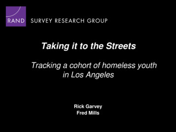
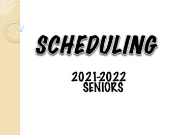
22BACKGROUNDLand-use in the Rego Park Study Area is a mix of commercial and residential buildings. There is oneSenior Center located in or near the study area: the Rego Park Senior Center on the north side of QueensBoulevard between 62nd and 63rd Avenues.There are no medical centers within the Rego Park study area, but Forest Hills (NSLIJ) and Saint John‟sQueens hospitals are located nearby at the intersections of 66th Avenue and 102nd Street, and QueensBoulevard and 58th Avenue, respectively.There are two schools inside the study area (a list of school names and addresses is shown in Exhibit 5).Bicycle FacilitiesThe 2010 NYC Bike Map shows “existing” and “planned/proposed” bicycle facilities throughout the city.There are no existing bike routes in the vicinity of the Rego Park Study Area; however, there areplanned/proposed routes on 63rd Road and 62nd Drive (Exhibit 2).BACKGROUNDTruck RoutesThe local truck routes along Junction Boulevard and 62nd Drive as well as the through truck route alongQueens Boulevard are included in the study area. The through truck route along the Long IslandExpressway and the local truck route along 108th Street are also in close proximity to the study area (Exhibit3).Bus Lines and SubwayFive bus lines operate within the study area including (Exhibit 4): Q60:Operates along Queens BoulevardQ38:Operates along 63rd Road and 62nd DriveQ72:Operates along Junction BoulevardQM11:Express bus service operates along Queens Boulevard and 63rd RoadQM12:Express bus service operates along 62nd DriveQM1, QM5, QM6, QM7, QM8, QM18, X63, X64 and X68: Operate along Queens BoulevardTheandsubway lines run along Queens Boulevard through the study area (Exhibit 4). Subwaystations for the andlines are located at the following intersections:66th Street and 18th Avenue65th Street and 20th AvenueEXHIBIT 1 – AREA MAPRego ParkSafe Streets for SeniorsFinal ReportPage 5
2 BACKGROUNDEXHIBIT 2 – BIKE MAPEXHIBIT 3 – TRUCK MAPEXHIBIT 4 – TRANSIT MAPEXHIBIT 5 - LIST OF SCHOOLS IN THE STUDY AREASCHOOL NAMEADDRESSRego Park Jewish Center – Life Skill Pre-School9730 Queens Boulevard, NY 11374-3245Montessori School – Forest Hills6704 Austin Street, NY 11375-3556Rego ParkSafe Streets for SeniorsFinal ReportPage 6
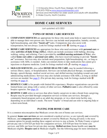
3 EXISTING CONDITIONS3EXISTING CONDITIONS3.1ABOUT THE STUDY AREAThe Rego Park Study Area consists of onemajoreast-westcorridor,QueensBoulevard, between 67th Avenue and 63rdAvenue (Photo No. 1). There are also threenorth-south corridors: Junction Boulevard,67th Avenue, and 63rd Avenue. The majorcorridor, Queens Boulevard, is a throughtruck route, while Junction Boulevard and aportion of 63rd Avenue are local truckroutes (Exhibit 3). Queens Boulevard alsocarries several NYCT express bus linesincluding QM1, QM5, QM6, QM7, QM8,QM11, QM18, X63, X64 and X68, as wellas local route Q60 (Exhibit 4). Many of thesenior residents interviewed showed somethconcerns about these corridors, especially Photo No. 1: Queens Boulevard and 64 RoadQueens Boulevard. The combination of (looking west)heavy traffic volumes, operational factorsand geometric factors make these corridors difficult for senior pedestrians to safely cross.3.2FIELD OBSERVATIONS AND SENIOR PEDESTRIANS CONCERNSThere were numerous issues that were repeatedly observed during the field visits and/orconveyed by senior pedestrians during interviews. Those issues are listed here: Insufficient pedestrian crossing time Missing crosswalk markings Missing or non-standard pedestrian ramps Length of crosswalks Missing pedestrian refuge islandsRego ParkSafe Streets for SeniorsFinal ReportPage 7
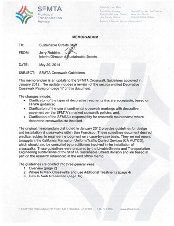
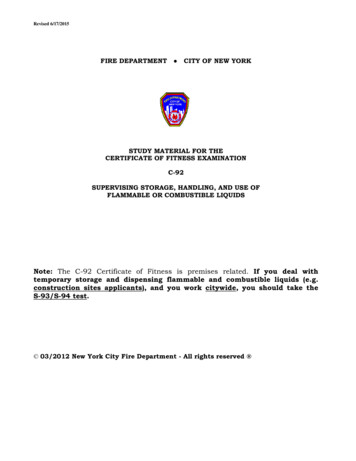
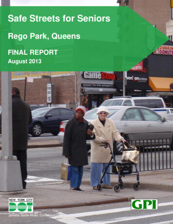
4 TRAFFIC OPERATIONS4TRAFFIC OPERATIONS4.1CRASH SUMMARYCrash data was obtained from the New York City Department of Transportation (NYCDOT) forthe Rego Park study area from 2001 through 2006. This data provides some details relating tothe circumstances and cause of each crash. Table 1 and Exhibit 6 show a summary of crashes.TABLE 1: DMV SIX YEAR CRASH SUMMARY (2001-2006)INTERSECTIONSENIOR PEDESTRIANCRASHESSENIOR PEDESTRIANFATALITIES62nd Drive98th Street10Queens Boulevard63nd Avenue/62nd Drive10Queens Boulevard63rd Drive/63rd Road10Queens Boulevard65th Road10Queens Boulevard67th Avenue1067th AvenueBooth Street1067th AvenueBurns Street10Saunders Street180063rd DriveTOTALRego ParkSafe Streets for SeniorsFinal ReportPage 8
4 TRAFFIC OPERATIONSEXHIBIT 6 - PEDESTRIAN CRASH STATISTICS (2001-2006)Rego ParkSafe Streets for SeniorsFinal ReportPage 9
4 TRAFFIC OPERATIONS4.2TRAFFIC VOLUMESIn order to analyze conditions for vehicles and pedestrians, traffic volume data wascollected at key locations (see Table 2).The results of the turning movement and pedestrian counts are included in AppendicesA and B and the Technical Supplements.TABLE 2: TRAFFIC VOLUME DATAINTERSECTIONATR1TMC2PEDCOUNTSQueens Boulevard and 63rd Street-XXQueens Boulevard and 67rd Avenue-XXNotes:1. Twenty-four hour Automatic Traffic Recorder (ATR)2. Turning Movement Counts (TMC‟s)Rego ParkSafe Streets for SeniorsFinal ReportPage 10
4 TRAFFIC OPERATIONS4.3SIGNAL TIMING: PEDESTRIAN INTERVALAccording to the MUTCD 2009 (Manual on Uniform Traffic Control Devices) Section4E.06, a minimum of seven (7) seconds is allocated for a walk interval, in addition to apedestrian clearance time based on a walking speed of 3.5 feet per second. Allsignalized intersections within the study area were modified to provide a clearanceinterval of 3 feet per second to accommodate the slower walking speeds of seniors.Rego ParkSafe Streets for SeniorsFinal ReportPage 11
5 ILLUSTRATING THE SOLUTION5ILLUSTRATING THE SOLUTION5.1EXECUTIVE SUMMARY AND GENERAL RECOMMENDATIONSndDrivethndDrive97 Place & 6297 Street & 62Junction Boulevard & 62Queens Boulevard & 62ndxndDriverdxxxDrive/63 AvenuexxxrdSaunders Street & 63 AvenuexQueens Boulevard & Junction Boulevardxthrd97 Street & 63 RoadxrdrdQueens Boulevard & 63 Road/63 DriverdSaunders Street & 63 Drivethrd97 Street & 63 DrivexxxxRego ParkSafe Streets for SeniorsFinal ReportPage 12xxxxxxxxxQueens Boulevard & 64 Road (South)thth& 64 RoadSaundersStreet & 64 RoadxxxxQueens Boulevard & 64 Road (North)ththth& 64 RoadQueensBoulevard & 65 Avenue/65 RoadxxththxxxQueens Boulevard & 64 AvenuexxthxxxrdQueens Boulevard & 63 DrivexxLane DropxTurn Bay (Right/Left)xDaylightingxInstallation of Yield to Peds and/or Other SignsxxStripe ChannelizationxStripe Stop BarxStandard CrosswalkStripe Back-in ParkingDriveth98 Street & 62Stripe Parking LanendHigh-Visibility CrosswalkLocationsthCurb Extension / Neck-down / Median ExtensionInstallation / Replacement of Pedestrian RampsTABLE 3: SUMMARY OF SPECIFIC RECOMMENDATIONSxxxx
5 ILLUSTRATING THE SOLUTIONthSaunders Street & 65 RoadQueens Boulevard & 65 Road (North)Queens Boulevard & 66 AvenuexthQueens Boulevard & 66 Road/99 StreetxthQueens Boulevard & 67 AvenuexxxthWetherole Street & 67 AvenueAustin Street & 67 AvenuexxNote:x - Recommendations proposed by study of Safe Street for Seniors – Rego ParkRego ParkSafe Streets for SeniorsFinal ReportPage 13xxLane DropRight-turn BayDaylightingxxxxthBurns Street & 67 AvenueInstallation of Yield to Peds and/or Other SignsxththStripe ChannelizationxththStripe Back-in ParkingStripe Parking LaneStripe Stop BarStandard CrosswalkHigh-Visibility CrosswalkLocationsCurb Extension / Neck-down / Median ExtensionInstallation / Replacement of Pedestrian RampsTABLE 3: SUMMARY OF SPECIFIC RECOMMENDATIONS
5 ILLUSTRATING THE SOLUTIONGeneral Recommendations Place stop bars ten feet in advance of all crosswalksThe NYCDOT standard for placement of a stop bar is ten feet in advance of any markedpedestrian crosswalk, including school and high-visibility crosswalks. This positioninghelps to maximize pedestrian visibility and to minimize the potential forpedestrian/vehicle conflicts. Therefore, it is recommended that stop bars be placed tenfeet in advance of all crosswalks. Provide additional crossing time where feasibleA number of senior residents interviewed indicated that there was not enough time tocross many of the streets. Therefore, all of the signals, where possible, will be retimedto allow more crossing time for pedestrians. Green projects where feasibleAll medians, pedestrian plazas and curb extensions will be part of the Greenstreetsproject, where feasible. The Greenstreets project is a citywide program to convert pavedvacant traffic islands and medians into green spaces filled with shade trees, floweringtrees, shrubs and groundcover.Rego ParkSafe Streets for SeniorsFinal ReportPage 14
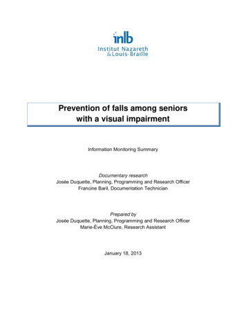
5 ILLUSTRATING THE SOLUTION5.2QUEENS BOULEVARDWithin the study area, Queens Boulevard isthemajoreast-westcorridor,accommodating large volumes of traffic(Photo No. 2). The project limits of thiscorridor are 63rd Avenue in the west to 67thAvenue in the east, which is about 0.70miles long. The width of Queens Boulevardvaries from 170 to 175 feet throughout thestudy area. In addition, this corridor hasboth north and south service roads.Neck-downs or curb extensions arerecommended at the following intersectionto shorten the crossing distance, slow downvehicular traffic and provide better visibilityfor senior pedestrians:Photo No. 2: Queens Boulevard and 65th Road Northwest corner of Queens (looking west)Boulevard and 63rd Avenue/62ndDriveRaised median island extensions or new raised median islands are recommended at thefollowing intersections to shorten the crossing distance and to increase visibility and improvepedestrian safety: Queens Boulevard and 63rd Drive/63rd Road Queens Boulevard and 67th AvenueDaylighting is recommended at the following locations to improve visibility for seniorpedestrians: Southwest corner of Queens Boulevard and 67th AvenueYield to Pedestrian or Pedestrian Crossing signs are recommended at the followingintersections to warn drivers: Queens Boulevard and 64th Road (Pedestrian Crossing sign) Queens Boulevard and 65th Road (Yield to Pedestrian sign) Queens Boulevard and 66th Avenue (Pedestrian Crossing sign) Queens Boulevard and 67th Avenue (Yield to Pedestrian sign)Provide new pedestrian ramp at the following intersection: Queens Boulevard and 63rd Avenue/62nd DriveHigh visibility crosswalks are recommended at the following intersections to warn drivers ofpedestrian crossings: Queens Boulevard north service road and 63rd Drive Queens Boulevard north service road and 64th Avenue Queens Boulevard north service road and 64th RoadRego ParkSafe Streets for SeniorsFinal ReportPage 15
5 ILLUSTRATING THE SOLUTION Queens Boulevard north service road and 65th Road Queens Boulevard north and south service roads and 66th Avenue Queens Boulevard north service road and 66th Road/99th StreetChannelization or gore striping is recommended at the following intersections: Queens Boulevard and 62nd Drive/63rd Avenue Queens Boulevard and 63rd Drive/63rd Road Queens Boulevard and 67th AvenueOther striping improvements recommended for this corridor include parking lanes at theintersections of Queens Boulevard and 62nd Drive/63rd Avenue, Queens Boulevard and JunctionBoulevard, Queens Boulevard and 63rd Road and Queens Boulevard and 67th Avenue.All improvements proposed along Queens Boulevard are shown in Exhibits 8 and 9.Rego ParkSafe Streets for SeniorsFinal ReportPage 16
5 ILLUSTRATING THE SOLUTION5.3SAUNDERS STREETWithin the study area, Saunders Street is aone-way minor corridor accommodatingwestbound traffic (Photo No. 3).Theproject limits are from 63rd Avenue in thewest to 67th Avenue in the east. The lengthof this corridor is 0.65 miles and its widthvaries from 31 to 33 feet within the studyarea. Parking is permitted on both sides ofthis street during most times of the day.Yield to Pedestrian signs are recommendedat the following intersection to warn drivers: Saunders Street and 63rd DriveStopAheadwarningsignsarerecommended at the following intersections:Photo No. 3: Saunders Street and 63rd Avenue(looking west) Both north and south sides ofSaunders Street in advance of 63rdAvenue Both north and south sides of Saunders Street in advance of 64th Road On the north side of Saunders Street in advance of 65th RoadHigh visibility crosswalks are recommended at the following intersection to warn drivers ofpedestrian crossings: Saunders Street and 63rd DriveAdvanced stop bars are recommended on all approaches at the intersection of Saunders Streetand 63rd Drive. Other striping improvements recommended for this corridor include parkinglanes at Saunders Street and 63rd Avenue.All improvements proposed along Saunders Street are shown in Exhibits 10 and 11.Rego ParkSafe Streets for SeniorsFinal ReportPage 17
5 ILLUSTRATING THE SOLUTION62ND DRIVE/63RD AVENUE5.462nd Drive is approximately 51 feet widebetween 99th Street and 97th Street, andapproximately 57 feet wide from 97th Streetto Queens Boulevard. The width of 63rdAvenue from Queens Boulevard
QM11: Express bus service operates along Queens Boulevard and 63rd Road QM12: Express bus service operates along 62nd Drive QM1, QM5, QM6, QM7, QM8, QM18, X63, X64 and X68: Operate along Queens Boulevard The and subway lines run along Queens Boulevard th