Transcription
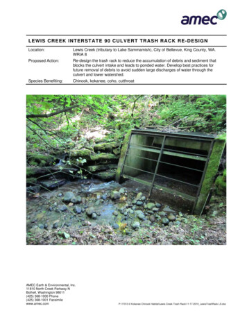
LEWIS CREEK INTERSTATE 90 CULVERT TRASH RACK RE-DESIGNLocation:Lewis Creek (tributary to Lake Sammamish), City of Bellevue, King County, WA.WRIA 8Proposed Action:Re-design the trash rack to reduce the accumulation of debris and sediment thatblocks the culvert intake and leads to ponded water. Develop best practices forfuture removal of debris to avoid sudden large discharges of water through theculvert and lower watershed.Species Benefiting:Chinook, kokanee, coho, cutthroatAMEC Earth & Environmental, Inc.11810 North Creek Parkway NBothell, Washington 98011(425) 368-1000 Phone(425) 368-1001 Facsimilewww.amec.comP:\17013-0 Kokanee Chinook Habitat\Lewis Creek Trash Rack\11-17-2010 LewisTrashRack LS.doc
SITE BACKGROUNDLewis Creek flows from its headwaters on the flank of Cougar Mountain, down to the southwesternshore of Lake Sammamish, Washington. The watershed is partly forested but has been developedover the past 20 years for residential purposes. The creek passes under Interstate 90 at the LakemontBoulevard exit where a substantial culvert and detention pond are used to convey stormwater runoff.Above I-90, the creek flows within the City of Bellevue; downstream, the creek is within the City ofIssaquah. Flows are typically less than 10 cfs, but heavy winter rains can generate flows over 200 cfs(Figure 1).The system of culverts under I-90, West Lake Sammamish Parkway and Newport Way areapproximately 1,000 feet in combined length (The Watershed Company 2006) and completely preventany species of fish from passing upstream. The inlet for this culvert system is located in a smallwooded ravine south of the intersection of Lakemont Boulevard and Newport Way. A metal trash rack,approximately eight feet wide by six feet tall, is attached to concrete walls and prevents large objectsfrom entering the culvert. Spaces between the metal bars are approximately 18 by 48 inches. Abovethe trash rack, a steep stepped bank of sediment reveals a history of debris and sedimentProject No. 0-915-17013-0P:\17013-0 Kokanee Chinook Habitat\Lewis Creek Trash Rack\11-17-2010 LewisTrashRack LS.docAMEC Earth & Environmental, Inc.3
accumulation upstream of the trash rack followed by episodic events of water and sediment dischargeto downstream during trash rack maintenance efforts by WSDOT (Figure 2).IMPORTANCE FOR KOKANEE AND/OR CHINOOK POPULATIONSThe lower half of Lewis Creek (approximately 0.75 miles downstream of I-90) provides the longestaccessible spawning reach in the Sammamish Basin (Berge and Higgins 2003). It is one of only threestreams in the Lake Sammamish basin that consistently receive spawning late-run kokanee.Escapement has varied widely over the past decade: from only tens of spawners in some years, toover 3,000 spawners in other years (Jackson 2008 as presented in HDR 2009). Ongoing fry-trappingstudies on Lewis Creek by Trout Unlimited are attempting to enumerate egg-to-fry survival. LewisCreek is an important part of the emergency supplementation program.Due to its proximity to Issaquah Creek, the delta and lower reaches of Lewis Creek could provideimportant non-natal rearing habitat for juvenile Chinook salmon seeking refuge from predation andhigh lake temperatures as they migrate out to sea. This project, while located almost a mile upstreamfrom the mouth, will help stabilize flows and sediment transport rates in the lower reaches of LewisCreek and will contribute to the success of downstream habitat improvement projects (see Project A),which are designed to benefit Chinook salmon.LIMITING FACTORSThe hydrology of Lewis Creek has been altered by the increasing amount of impervious surfaces inthe upper watershed, leading the flashy flows during rain events. These spikes in the hydrographoverwhelm the conveyance capacity of the system, and lead to flooding of adjacent properties. Highflow events can also erode large quantities of sediment from the bed and banks and deposit themdownstream.The I-90 culvert trash rack compounds this problem because it does not function appropriately duringhigh flow events. Debris flushed downstream is trapped, as intended, at the rack. As the debrisaccumulates, it reduces flow conveyance through trash rack, impounding water upstream. Water anddebris accumulate within the ravine upstream of the rack until it overflows the road and threatensinfrastructure. In response to this threat, WSDOT has used a backhoe to remove accumulated debrisfrom the rack, suddenly releasing impounded water. The current configuration of the trash rack andpresent maintenance operations do not permit gradual clearing of the rack. The resulting emergencycleanings lead to extremely high flows of water and sediment, which damage the downstreamchannel. Cleanings are most likely to take place in the winter when eggs are incubating in the stream;therefore, egg-to-fry survival is jeopardized.Project No. 0-915-17013-0P:\17013-0 Kokanee Chinook Habitat\Lewis Creek Trash Rack\11-17-2010 LewisTrashRack LS.docAMEC Earth & Environmental, Inc.4
Salmon access to the project area from downstream is currently blocked by the I-90 culvert. Theproposed project does not intend to fix this problem, nor does it intend to enhance in-stream habitatwithin the project area. This project has the potential to address the most significant system-widelimiting factors, sudden discharges of water and sediment, which will improve virtually all of theavailable habitat downstream.PROPOSED ACTIONThe project will redesign the trash rack and intake structure to allow water to flow into the culvert at awider range of flows and stage heights. It will also establish a coarse-scale debris trap upstream toprevent large objects from collecting on the rack. Finally, best practices for clearing debris from thetrash rack will be developed that emphasize a gradual release of water, and for work to be performedbefore water is impounded.EXPECTED BENEFITSThe project will help restore the natural hydrology of Lewis Creek, reduce the risk of extreme flowevents that cause damage to the stream bed, banks, and properties in the lower watershed. Theproject is expected to lead to higher survival of kokanee, coho, and cutthroat from egg to fry.Project No. 0-915-17013-0P:\17013-0 Kokanee Chinook Habitat\Lewis Creek Trash Rack\11-17-2010 LewisTrashRack LS.docAMEC Earth & Environmental, Inc.5
SELECTION CRITERIA SCORING MATRIX RESULTSSocio-PoliticalCostsWatershed Context andConditionLimiting FactorsLocationCategoryBasic QuestionScoring QuestionWhat is the historical and current significance of theIn which stream and reachsite for kokanee?is the project located?What is the historical andcurrent significance forWhat is the historical and current significance of thekokanee and/or Chinook?site for Chinook?Would the project addressspecific limiting factors?Is project successdependent on conditionselsewhere in thewatershed?ScoreJustification10Historically and currently important for late-runkokanee; part of the supplementation effort4Potential use of mouth/delta by juveniles. Anecdotalevidence of historic use for spawning but no recentconfirmationsHow well does the project address factors limitingkokanee?9Project would address causes of flashy hydrographHow well does the project address factors limitingChinook?4May reduce frequency of high energy bed-formingflows and improve sediment composition at mouthDo surrounding land uses and/or managementstrategies lead to constraints (or opportunities) for theproposed restoration? Examples: water quality,sediment, flow regime, fish access, riparian vegetation9Project is an opportunity to mitigate impacts fromsurrounding land uses.Who owns project area and is long-term protectionensured?9WSDOT Right of WayWho owns neighboring parcels? What land uses occurupstream and/or downstream that could be affected byrestoration? What risks do those uses pose to the sitenow and in the future?6Private Residential, WSDOTWhat is the order of magnitude cost estimate?9Rough estimate of total project cost 50K5Unsure of funding strategy. WSDOT and/orCi.Bellevue may contributeAre specific grants or appropriations in mind that wouldbe likely to fund this type of project?4Unsure of funding strategyDoes the project have public support and/or supportfrom the local jurisdiction?9Project identified by WSDOT and Ci.Issaquah as aproblem area7Yes, but degree of support not known1NoHow expensive willproposed action be? WhatAre matching funds available?is the likelihood forfunding?What other considerationswill determine feasibility ofDoes the project have landowner support?implementation?Does the project utilize or create public access?
Figure 2. Upstream of the trash rack and culvert intake, multiple benches of sediment suggest a cycle of deposition (when trash rack is blocked) and massivescouring (when trash rack is cleaned and flows are releasedLEWIS CREEK INTERSTATE 90 CULVERT TRASH RACK RE-DESIGN
Base image for the sketch on the following pageLEWIS CREEK INTERSTATE 90 CULVERT TRASH RACK RE-DESIGN
Bollards installed upstream of the trash rack may prevent coarse material (i.e., large wood) from clogging the culvertLEWIS CREEK INTERSTATE 90 CULVERT TRASH RACK RE-DESIGN
A metal trash rack, approximately eight feet wide by six feet tall, is attached to concrete walls and prevents large objects from entering the culvert. Spaces between the metal bars are approximately 18 by 48 inches. Above the trash rack, a steep stepped bank of sediment reveals a history of debris and sediment AMEC Earth & Environmental, Inc.