Transcription
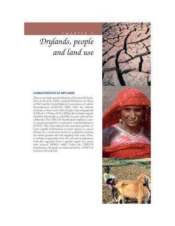
CHAPTER 1Drylands, peopleand land useCHARACTERISTICS OF DRYLANDSThere is no single agreed definition of the term drylands.Two of the most widely accepted definitions are thoseof FAO and the United Nations Convention to CombatDesertification (UNCCD, 2000). FAO has defineddrylands as those areas with a length of growing period(LGP) of 1–179 days (FAO, 2000a); this includes regionsclassified climatically as arid (Plate 1), semi-arid and drysubhumid. The UNCCD classification employs a ratioof annual precipitation to potential evapotranspiration(P/PET). This value indicates the maximum quantity ofwater capable of being lost, as water vapour, in a givenclimate, by a continuous stretch of vegetation coveringthe whole ground and well supplied with water. Thus,it includes evaporation from the soil and transpirationfrom the vegetation from a specific region in a giventime interval (WMO, 1990). Under the UNCCDclassification, drylands are characterized by a P/PET ofbetween 0.05 and 0.65.
6CHAPTER 1 Drylands, people and land useglobal biophysical processes by reflecting andabsorbing solar radiation and maintaining thebalance of atmospheric constituents (Ffolliottet al., 2002). They provide much of the world’sgrain and livestock, forming the habitat thatsupports many vegetable species, fruit trees andmicro-organisms.PLATE 1A view of dryland (with villagein the background) in the Sahel,southern Niger (P. Cenini)According to both classifications, the hyperaridzones (LGP 0 and P/PET 0.05), or truedeserts, are not included in the drylands and donot have potential for agricultural production,except where irrigation water is available.While about 40 percent of the world’s total landarea is considered to be drylands (according tothe UNCCD classification system), the extent ofdrylands in various regions ranges from about 20percent to 90 (Table 1 and Figure 1).Drylands are a vital part of the earth’s humanand physical environments. They encompassgrasslands, agricultural lands, forests and urbanareas. Dryland ecosystems play a major role inHigh variability in both rainfall amounts andintensities are characteristics of dryland regions,as are the occurrence of prolonged periods ofdrought. A drought is defined as a departurefrom the average or normal conditions,sufficiently prolonged (1-2 years - FAO, 2004) asto affect the hydrological balance and adverselyaffect ecosystem functioning and the residentpopulations. There are actually four differentways that drought can be defined (NationalWeather Service, 2004). Meteorological droughtis a measure of the departure of precipitationfrom normal. Due to climatic differences, adrought in one location may not be a droughtin another location. Agricultural drought refersto situations where the amount of soil wateris no longer sufficient to meet the needs of aparticular crop. Hydrological drought occurswhen surface and subsurface water supplies arebelow normal. Socioeconomic drought describesthe situation that occurs when physical watershortages begin to affect people. This report isprimarily concerned with agricultural droughts.The terms drought and aridity are sometimesused interchangeably, but they are different.TABLE 1Regional extent of drylandsARIDITY ZONEAridREGION(1 000 km2)Semi-arid(%)(1 000 km2)Dry subhumid(%)(1 000 km2)All drylands(%)(1 000 km2)(%)Asia (incl. Russia)6 164137 649164 588918 40139Africa5 052175 073172 808912 93343Oceania3 488393 53239996118 01689North America37923 436162 081105 89628South America40122 980172 223135 61432Central Americaand Caribbean4211869630242101 35958EuropeWorld total503737961171 3592415 9101223 7391813 9091053 55840Source: UNSO/UNDP, 1997.
7Water and Cereals in DrylandsFIGURE 1Distribution of drylands in the worldHyperaridAridSemiaridDry SubhumidWorld Country Boundaries00.050.200.500.65 P/PETSource: IIASA/FAO, 2003.Aridity refers to the average conditions of limitedrainfall and water supplies, not to the departuresfrom the norm, which define a drought. Allthe characteristics of dryland regions must berecognized in the planning and managementof natural and agricultural resources (Jackson,1989). Because the soils of dryland environmentsoften cannot absorb all of the rain that falls inlarge storms, water is often lost as runoff (Brookset al., 1997). At other times, water from a rainfallof low intensity can be lost through evaporationwhen the rain falls on a dry soil surface. Moldenand Oweis (2007) state that as much as 90percent of the rainfall in arid environmentsevaporates back into the atmosphere leavingonly 10 percent for productive transpiration.Ponce (1995) estimates that only 15 to 25 percentof the precipitation in semiarid regions is usedfor evapotranspiration and that a similar amountis lost as runoff. Evapotranspiration is the sumof transpiration and evaporation during theperiod a crop is grown. The remaining 50 to70 percent is lost as evaporation during periodswhen beneficial crops are not growing.Three major types of climate are found indrylands: Mediterranean, tropical and continental(although some places present departures fromthese). Dryland environments are frequentlycharacterized by a relatively cool and dry season,followed by a relatively hot and dry season,and finally, by a moderate and rainy season.There are often significant diurnal fluctuationsin temperatures which restricts the growth ofplants within these seasons.The geomorphology of drylands is highlyvariable. Mountain massifs, plains, pediments,deeply incised ravines and drainage patternsdisplay sharp changes in slope and topography,and a high degree of angularity. Streams and riverstraverse wide floodplains at lower elevationsand, at times, are subject to changes of course,often displaying braided patterns. Many of theselandforms are covered by unstable sand dunesand sand sheets. Dryland environments aretypically windy, mainly because of the scarcityof vegetation or other obstacles that can reduceair movement. Dust storms are also frequentwhen little or no rain falls.Soils in drylands are diverse in their origin, structureand physicochemical properties. In general, theyinclude Calcisols, Gypsisols. Leptosols and Steppesoils (FAO, 2004) (Figure 2). Important featuresof dryland soils for agricultural production aretheir water holding capacity and their abilityto supply nutrients to plants. As there is littledeposition, accumulation or decomposition oforganic material in dryland environments, the
Dryland Soils (22%)Cracking Clay Soils (5%)VertisolsSaline and Sodic Soils (4%)Solonetz, Solonchaks, Salt FlatsSandy Soils (12%)ArenosolsSoils with Clay Accumulation (9%)LuvisolsSource: World Soil Resources Map. FAO/EC/ISRIC, 2003.AndosolsVolcanic Soils ( 1%)AcrisolsLeached and Weathered Soils ( 1%)Ferralsols, NitisolsVery Weathered Soils (2%)Soils of the Lowlands (5%)Fluvisols, Gleysols, PlanosolsSteppe Soils (13%)Kastanozems, Chernozems, Phaeozems, GreyzemsLithosols, Rock Outcrops, Rendzina, RankersSlightly Weathered Soils (4%)CambisolsSoils of Footslopes (6%)RegosolsShallow Soils (18%)Calcisols, GypsisolsFIGURE 2Major soil types of drylands8CHAPTER 1 Drylands, people and land use
9Water and Cereals in Drylandsorganic content of the soils is low and, therefore,natural soil fertility is also low.Much of the water that is available to peopleliving in drylands regions is found in large riversthat originate in areas of higher elevation (e.g. theNile, Tigris-Euphrates, Indus, Ganges, Senegal,Niger and Colorado Rivers). Groundwaterresources can also be available to help supportdevelopment. However, the relatively limitedrecharge of groundwater resources is dependentlargely on the amount, intensity and duration ofthe rainfall and soil properties, the latter includingthe infiltration capacity and waterholdingcharacteristics of the soil, which also influencethe amount of surface runoff. With currentmanagement practices, much of the rainfall islost by evapotranspiration or runoff. As a result,groundwater is recharged only locally by seepagethrough the soil profile. Surface runoff events,soil-moisture storage, and groundwater rechargein dryland regions are generally more variableand less reliable than in more humid regions. Insome areas, important reservoirs of fossil groundwater exist and continue to be used by humanpopulation. Fossil water is groundwater that hasremained in an aquifer for millennia. Extractionof fossil groundwater is often called miningbecause it is a non-renewable resource. Forsuch aquifers, including the vast U.S. Ogallalaaquifer, the deep aquifer under the North ChinaPlain, and the Saudi aquifer, depletion can bringpumping to an end. In some cases, farmers canconvert to dryland farming, but in arid regions itis the end of farming. Brown (2008) cited a 2001China study that showed the water table underthe North China Plain is falling fast and this areaproduces over half of the country’s wheat and athird of its maize. He also cited a World Bankstudy that reported 15 percent of India’s foodsupply is produced by mining groundwater.Even in areas where groundwater is recharged,it is frequently used at rates that exceed therecharge rate. Water that is available for use inmany drylands regions can be affected also bysalinity and mineralization (Armitage, 1987).Dryland populations are frequently some of thepoorest in the world, many subsisting on lessthan US 1 per day (White et al., 2002).The population distribution patterns varywithin each region and among the climatezones comprising drylands. Regionally, Asiahas the largest percentage of population livingin drylands: more than 1 400 million people, or42 percent of the region’s population. Africa hasnearly the same percentage of people living indrylands (41 percent) although the total numberis smaller at almost 270 million. South Americahas 30 percent of its population in drylands, orabout 87 million people (Table 2).Rural people living in drylands can be groupedinto nomadic, semi-nomadic, transhumant andsedentary smallholder agricultural populations.Nomadic people are found in pastoral groupsthat depend on livestock for subsistence and,whenever possible, farming as a supplement.Following the irregular distribution of rainfall,they migrate in search of pasture and water fortheir animals. Semi-nomadic people are alsofound in pastoral groups that depend largely onlivestock and practice agricultural cultivation at abase camp, where they return for varying periods.Transhumant populations combine farming andlivestock production during favourable seasons,but seasonally they might migrate along regularroutes using vegetation growth patterns ofaltitudinal changes when forage for grazingdiminishes in the farming area. Sedentary (smallholder) farmers practise rainfed or irrigatedagriculture (Ffolliott et al., 2002) often combinedwith livestock production.The human populations of the drylands live inincreasing insecurity due to land degradationand desertification and as the productive landper capita diminishes due to population pressure(Plate 2). The sustainable management ofdrylands is essential to achieving food securityand the conservation of biomass and biodiversityof global significance (UNEP, 2000).DRYLANDS PEOPLELAND USE SYSTEMS IN DRYLANDSDrylands are inhabited by more than 2 000million people, nearly 40 percent of the world’spopulation (White and Nackoney, 2003).Dryland farming is generally defined as farmingin regions where lack of soil moisture limits cropor pasture production to part of the year. Dryland
10CHAPTER 1 Drylands, people and land usefarming systems are very diverse, including avariety of shifting agriculture systems, annualcroplands, home gardens and mixed agriculture–livestock systems, also nomadic pastoral andtranshumant systems (Figure 3 and Plate 3).They also include fallow systems and otherindigenous intensification systems (FAO, 2004)for soil moisture and soil fertility restoration.Haas, Willis and Bond (1974) defined fallowas a farming practice where and when no cropis grown and all plant growth is controlled bytillage or herbicides during a season when a cropmight normally be grownas small-holders, operate and survive in thesevaried, changeable and hazardous environmentsby being able to manage the multiple risks(FAO, 2004) through diversification, flexibilityand adaptability (Mortimore and Adams, 1999).Stewart and Koohafkan (2004) and Stewart,Koohafkan and Ramamoothy (2006) havealso reviewed the importance and some of theconstraints of dryland farming. Expansion ofcropland areas in dryland regions can fail owingto overexpansion of inappropriate productiontechnologies into the drylands environment.Increased population pressures and humanexpansion into drier areas during long wet periodsleave an increasing number of people vulnerableto drought. Removing critical productionelements (e.g. dry-season grazing areas) from thetraditional complex land-use systems through theintroduction of irrigated and non-irrigated crops,or the increased industrial and urban use of water,break links in traditional production chains.The major farming systems of the drylands varyaccording to the agro-ecological conditionsof these regions. A recent study of the LandDegradation Assessment in Dryland projects(LADA, 2008) identified the major farmingsystems in drylands according to socio-economicinformation, agro-ecology and possibilities forirrigation. The majority of the drylands used foragriculture is under cereal cultivation. Annex2 summarizes farming practices in some of themajor dryland areas of the world.One of the reasons why dryland farming hasgenerally been inefficient is the poverty trap.Resource-poor people living in marginalenvironments try to survive by avoiding damageresulting from hazards. Avoiding risks oftenentails maximizing the use of labour whileminimizing the use of capital-intensive resourcesas the poor cannot afford to invest sufficientlySuccessful dryland farming requires the integratedmanagement of soil, water, crops and plantnutrients. Small-scale, resource-poor, usuallysubsistence-based farmers, widely referred toTABLE 2Human populations of the world’s drylandsARIDITY ZONEAridSemi-aridDry subhumidAll drylandsREGION(1 000)(%)(1 000)(%)(1 000)(%)(1 000)Asia (incl.Russia)161 5545625 41118657 899191 444 9064240 5036117 64718109 37017267 56341AfricaOceania(%)27511 34255 318196 96025North America6 257241 0131612 030559 32325South America6 331246 8521633 7771286 99030C. Americaand Caribbean6 494612 8881112 312831 71928EuropeWorld total629028 7165111 21620140 58625222 0434873 8714941 922172 038 04737Source: UNSO/UNDP, 1997.
11Water and Cereals in DrylandsPLATE 2Bedouin families use the meagre vegetationof the steppes for cooking and heating. Thedeterioration of the fragile dryland ecosystemhas also led to their impoverishment (M. Marzot)in their crops or in their natural resource base.This leads not only to economic inefficiencybut also to exploitation and degradation of theresource base, both of which in turn sustaintheir poverty. Evidence is often contradictory,for example, Mazzucato and Niemeijer (2000)found little evidence of widespread degradationof crop and fallow land discussing conditionsin Burkina Faso. However. they do not disputelocalized areas of severe degradation, norsuggest that Sahelian soils are particularly fertile.Mazzucato and Niemeijer (2000) do questionthe widespread belief that low-external-inputpractices used by West African farmers areleading to region wide land degradation and alsoargue that degradation assessments need to dealbetter with the spatial and temporal dimensionsof the observed problems and land uses (Frescoand Kroonenberg, 1992; Rasmussen, 1999).PLATE 3An example of dryland agriculturein the Asia-Pacific regionDryland farming is dependent solely on the wateravailable from precipitation. However, drylandfarming often depends on having stored soilwater at the time of seeding a crop to supplementthe rainfall received during the growing season(Dregne and Willis, 1983). This is particularly truein Canada and the United States of America, alsoto some extent in Australia and Argentina, wheredryland farming, at least until recently, dependedlargely on fallow conserving soil moisture. Thus,limited and high-risk production in one seasonis forfeited in anticipation that there will be atleast partial compensation by increased cropproduction in the following season.With the development of dryland farming inthe steppe, water-conservation techniques hadto be developed because moisture from seasonalprecipitation was usually inadequate for cropgrowth and maturation (El-Swaify et al., 1985).The practice most widely adopted was summerfallow. Practised in areas around the Mediterraneanfor centuries, summer fallow became practical inthe steppes and grew rapidly with mechanization.Summer fallow systems are inefficient becauseoften only 15–20 percent of the precipitationoccurring during the fallow period is actually savedas stored water. The remainder is lost throughevaporation and runoff. However, summer fallowis very effective in reducing risk and ensuringsome yield even in low-rainfall years (Lal andPierce, 1991). Careful farming practices such asweed control, maintenance of a stubble mulchand leaving the surface in large clods can result inlarger amounts of stored water.Dryland farming is at best a risky enterprise. Afavourable pattern of precipitation during thegrowing period can result in good yields evenwhen the annual total is much below average. Incontrast, there is no assurance of good productionin years even when precipitation is greater thanaverage if it occurs at times when crop waterrequirements are low.LAND DEGRADATION IN DRYLANDSThe rapid population growth in drylands dueto improvements in health conditions and otherfactors has placed tremendous pressure on thenatural-resource base. Often, the inevitableresult of increasing population in resource-poor
12CHAPTER 1 Drylands, people and land useareas is land degradation defined as the loss ofproduction capacity of the land (FAO, 2000a).In this context, this should be understood as aresult of a combination of natural processes andhuman activities that cause the land to becomeunable to properly sustain its ecological andeconomic functions. Traditionally, simplistic,explanations confused the issue,where the landusers were considered the “guilty” - and blamedfor the degradation (Gisladottir and Stocking,2005). However, studies over the last ten tofifteen years conclude that the causes of landdegradation are far more complex and thatland degradation may result from much higherlevel policy and market failure rather thanfrom failures of the poor land user (Gisladottirand Stocking, 2005). In the past drylands havebeen neglected by national and internationaldevelopment policies - adequate investmentsto generate positive results and reverse landdegradation have been deficient (Johnson,Mayrand and Paquin, 2006).Desertification (Plate 4) is defined as landdegradation in drylands caused by climatevariability and human activities (UNCCD, 2000;FAO, 2000a). In the case of drylands, landdegradation results in desertification (Stewartand Robinson,1997). Droughts, common to theseareas, exacerbate the degradation processes.It is estimated that almost 75 percent of thecropland in Central America is seriously degraded;20 percent in Africa (mostly pasture); and 11percent in Asia (IFPRI, 2001). These data suggestthat, globally, up to 40 percent of agriculturalland is seriously affected by soil degradation.Oldeman et al. (1991) suggest that landdegradation can result in the following reductionsin agricultural productivity: light: somewhat reduced agriculturalproductivity; moderate: greatly reduced agriculturalproductivity; strong: biotic functions largely destroyed,non-reclaimable at farm level; extreme: biotic functions fully destroyed,non-reclaimable.Agricultural productivity is affected by manyfactors apart from soil quality, e.g. rainfall,deforestation, population pressures, climate,labour and technology. Because of theinterdependent nature of land and its productivity,it is necessary to base claims of land degradationon multiple, complementary proxies thatinclude properties of land (e.g. of soil, water andvegetation) as well as productivity indicators.Tobler et al. (1995) stated that the increase inFIGURE 3Land Use SystemsForestry Natural and/or Protected (5%)Forestry and Livestock (4%)Forestry and Plantations (1%)Pasture Natural and/or Protected (8%)Extensive Pastoralism (16%)Moderate to Intensive Pastoralism (24%)Mixed Pastoralism and Agriculture (13%)Irrigated Agriculture (4%)Rainfed Agriculture (4%)Bare Areas Natural and/or Protected (7%)Bare Areas with Extensive Pastoralism (11%)Wetland ( 1%)Urban (2%)
13Water and Cereals in DrylandsPLATE 4Desertification in the Sudan. Goats feed on asolitary Acacia shrub (R. Faiduttti)population density is a major factor influencingland degradation, particularly in semi-arid andarid regions. Kirschke, Morgenroth and Franke(1999) claim that data from 73 developingcountries have shown that deforestation isa causative factor for both wind and watererosion under arid and semi-arid conditions.Overexploitation of vegetation for domesticuses such as fuelwood and domestic timberis also a cause of degradation of the resourcebase, particularly in the Sahel belt of Africa,western Argentina, the Islamic Republic ofIran, and Pakistan (Kruska, Perry and Reid,1995). Hazell (1998) stated that, despite someout-migration, human populations continueto grow in many less-favoured areas, butcrop yields grow little or not at all, resultingin worsening poverty, food insecurity andwidespread degradation of natural resources.Salinity also poses a major management problemin many non-irrigated areas where croppingrelies on limited rainfall (FAO, 2005). Althoughdryland salinity has been a threat to land andwater resources in several parts of the world, itis only in recent years that the seriousness of theproblem has become widely known. In rainfedagriculture, intrusion of saline seawater to areaslying near the sea can cause land salinizationduring dry periods (Ghassemi et al., 1995). Basedon the FAO/UNESCO Soil Map of the World,the total area of saline soils is 397 million ha andthat of sodic soils is 434 million ha that are notnecessarily arable but cover all salt-affected landsat global level. If it is accepted that 45 million haof the current 230 million ha of irrigated landare salt-affected soils (19.5 percent), then in theglobal total of the almost 1 500 million ha ofdryland agriculture, 32 million ha are salt-affectedsoils (2.1 percent) caused to varying degrees byhuman-induced processes (Ghassemi, Jakemanand Nix, 1995). Salt-affected soils have lowerproductivity and need careful management butcan be improved. Although many countries areusing salt-affected soils because of their proximityto water resources and the absence of otherenvironmental constraints, there is a clear needfor a sound scientific basis to optimize theiruse, determine their potential, productivity andsuitability for growing different crops, and identifyappropriate integrated management practices.All continental regions have experiencedPLATE 5Salinization in IranAnother common problem associated with landdegradation in drylands is the development ofsalt-affected soils (saline, saline–sodic and sodicsoils) resulting from changes in the local waterbalance and the accumulation of excess salts inthe rootzone. Dregne, Kassas and Rozanov (1991)estimated that about 41 million ha of irrigated landin the world’s dry areas are affected by variousprocesses of degradation, mainly waterlogging(20 million ha) and salinization and sodication (21million ha). In the 11 countries surveyed with atotal irrigated area of 158.7 million ha (70 percentof the world’s irrigated land), 29.6 million ha (20percent) are salt-affected soils.
14CHAPTER 1 Drylands, people and land useFIGURE 4Conceptual model of the effects of temperatureand precipitation on the difficultyof developing sustainable agro-ecosystemsin semi-arid regionsSource:Stewart, Lal and El-Swaify, 1991a decrease in arable land per capita in every5-year period reported. From 1965 to 1995, thedecrease was 40 percent in Asia and more than50 percent in Africa (FAO, 2000a). Sung-Chiao(1981) identified resource degradation as a majorlimitation to productivity in many arid andsemi-arid regions of China.In the past, under lower population densityand with intensification of agriculture, drylandsgenerally recovered following long droughts.However, under current conditions, they tend tolose their biological and economic productivitymore rapidly and seriously. Stewart, Laland El-Swaify (1991) developed a simplifiedconceptual model of the potential for soildegradation as the climate becomes hotter anddrier. The relationships presented in Figure 4suggest that soil degradation processes are morerapid in hotter and drier climates, making itmore difficult to sustain the soil-resource base.Whenever an ecosystem such as a grasslandprairie in a semi-arid region is transformed intoan arable system for food and fibre production,several soil degradation processes are set inmotion (Stewart, Lal and El-Swaify, 1991). Thisis particularly the case where raindrops falldirectly onto the bare soil surface, not protectedby vegetation, crop residues, mulches, etc. Othereffects are a decline in soil organic matter (SOM),increased wind and water erosion, deteriorationof soil structure, salinization and acidification.EFFECTS OF LIVESTOCKON THE RESOURCE BASELivestock have both positive and negative effectson the resource base, particularly the soil indrylands. They trample the soil which, dependingon the soil type and status, frequently leads tocompaction. The resulting higher bulk densitieslower yields by inhibiting root development,reducing infiltration and waterholding capacity.Compaction also makes cultivation (mechanicalor manual) more difficult and energy intensive.Sandford (1988) reported that livestock, mainlycattle, consume up to 60 percent of the cropresidues remaining on the surface after a grainharvest. Unless the manure is recycled, removalof crop residues by livestock (or for fuel uses)increases losses of nitrogen and phosphorusby 60–100 percent over the amounts removedin the grain. Where crop residues are burnedon the land, most of the nitrogen and organicmatter (on the surface and within the upper cmsof the soil profile) are lost, but most of the othernutrients are recycled.In some countries where dryland ecosystemspredominate, overgrazing (Plate 6) is the majorcause of land degradation, e.g. in the LibyanArab Jamahiriya, Tunisia, the Islamic Republicof Iran, Iraq, the Syrian Arab Republic, andvirtually the whole Sahel belt of Africa (FAO,1998a). Overgrazing is also a major cause of landdegradation in many parts of Central Asia, SouthAmerica such as Brazil and Argentina, as well asin some developed countries including Australiaand the western United States of America.Drought presents major challenges for mixedfarming operators in semi-arid regions. Mixedfarming is defined here as involving crops,livestock and/or trees (ASA, 1976). Mixedfarming systems include those in which morethan 10 percent of the dry matter fed to animalscomes from crop by-products/stubble or wheremore than 10 percent of the total value ofproduction comes from non-livestock farmingactivities (FAO, 1996b).In a drought situation, overgrazed mixedfarming systems can undergo the removal ofmuch of the surface vegetation, increasing thesoil’s vulnerability to serious wind erosion(Dregne, 2002). A producer anticipating this
15Water and Cereals in DrylandsPLATE 6The result of overgrazing on the outskirts ofAmman city (R. Faidutti)problem should reduce the number of livestock,or remove them from the grazed areas andfeed them a balanced ration for survival. Lotfeeding and zero grazing become increasinglyimportant strategies to retain plant cover andstructural stability of the surface soil in order tosustain resources in the long term. These optionsare unlikely to be available to smallholders orpastoralists in developing countries.With careful attention to the plant-nutrient balance,mixed farming is, environmentally, probably themost desirable system (Powell et al., 2004). Whereappropriate, it should be the focus for farmers,agricultural planners and decision-makers. Thechallenge will be to identify the technologies andpolicies that enable sustained growth to satisfythe increasing demand for meat and milk. Despitethe advantages of mixed farming, current trendsin drylands point towards farmers choosing tospecialise in either crop or livestock production.It is recommended that these trends should beresisted. It is being increasingly recognised thatlivestock play a vital role in stabilizing productionand income in cereal-producing regions. Livestockgraze crops/ residues and provide some income inyears when climate conditions are so adverse thatgrain production is unprofitable. Livestock increasethe sustainability of livelihoods in drylands,particularly in years of low precipitation.EFFECTS OF CLIMATE CHANGEON DRYLANDSThe global increase in atmospheric concentrationsof carbon dioxide (CO2) and other greenhousegases (particularly methane) over the past 250years are attributed primarily to fossil fuelcombustion and land use change (including interalia deforestation, biomass burning, draining ofwetlands, ploughing and use of fertilizers) andnow far exceed pre-industrial values determinedfrom ice cores spanning many thousands ofyears (IPCC, 2007). The global atmosphericconcentration of carbon dioxide has increasedfrom a pre-industrial value of about 280 ppm to379 ppm in 2005 (IPCC, 2007). The atmosphericconcentration of carbon dioxide in 2005 exceedsby far the natural range over the last 650,000years (180 to 300 ppm) as determined from icecores (IPCC, 2007).
large storms, water is often lost as runoff (Brooks et al., 1997). At other times, water from a rainfall of low intensity can be lost through evaporation when the rain falls on a dry soil surface. Molden and Oweis (2007) state that as much as 90 percent of the rainfall in arid environments evaporates back into the atmosphere leaving