Transcription
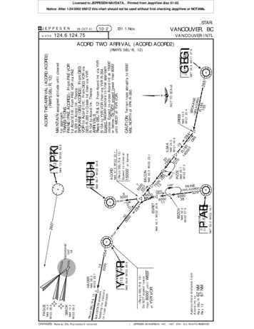
CHANGES: Runway 26L/R procedure removed.142000VANCOUVERWEST PAINE110.6APAEEPD(L)BEZOV149 N48 32.2W122 27.5BACON15000'(Rwys 08L/R & 12)Expect to cross ator below(GEG.AC EORD2)FL180155SPOKANN48 13.0W121 20.4CREEB265 NOT TO SCALEN47 33.9 W117 37.6GEGSPOKANE115.5 GEGD(H)CAUTION: Terrain rises abruptly to 6000'MSL NORTH of YPK R-260.N48 43.3 W122 23.17513 00D5075 2 0ILSAA00104N48 24.0 W121 42.9D7PIZZE019N48 35.7FL11W122 07.340 8028400T D8950 7D3 0075 D254500600011EGRET284D930 00R149 DN48 42.7 W122 30.630 3000N48 47.5 W122 32.1ACORDACORD TWO ARRIVAL (ACORD.ACORD2)(RWYS 08L/R, 12)N47 55.2 W122 16.74 124.6 124.7562 NM67 NMR10.Eff.1.Nov.Approximate distance fromAcord Int to:Rwy 08L/RRwy 128000'YVR VOR(Rwys 08L/R & 12)Do NOT expect lowerthanuntilof264 N48 56.7 W122 34.8WHATCOMH113.0U HUHHD(H)10-2DY115.9VYVRRN49 08.3W123 29.7HADERMAINTAIN assigned altitude until clearedfor approach.TRANSITIONSPAINE (PAE.ACORD2): From PAE VORto Acord Int: From PAE VOR via PAER-329 to Acord Int. ThenceSPOKANE (GEG.ACORD2): From GEGVOR to Acord Int: From GEG VOR viaGEG R-265 to Creeb Int then via YVRR-104 to Acord Int. ThenceARRIVALSRwys 08L/R & 12: From Acord Int via YVRR-104 to YVR VOR then via YVR R-264.Expect RADAR vectors to final approachcourse. Expect to cross Acord Int at 15000'or below. Do NOT expect lower than 8000'until WEST of YVR VOR.ACORD TWO ARRIVAL (ACORD.ACORD2)(RWYS 08L/R, 12)26 OCT 01N49 04.6 W123 09.0MAINTAIN preheadinsentgfto fina or vectorsl approach& 12VancouverIntl14112.4 YPKYPKN49 13.0 W122 42.9PITT MEADOWSJEPPESENRwys08L/RN49 13.3W123 29.2260 D-ATISSEKOKFAGUEN49 14.2W123 28.6Licensed to JEPPESEN NAVDATA, . Printed from JeppView disc 01-02.Notice: After 1/24/2002 0901Z this chart should not be used without first checking JeppView or NOTAMs.STAR.VANCOUVER INTLVANCOUVER, BCPA(PAE.ACORD2) 329600038INE JEPPESEN SANDERSON, INC., 1987, 2001. ALL RIGHTS RESERVED.
CHANGES: See other side.VICTORVANCOUVERN49 04.6 W123 09.0115.9 YVRLANNEYPKN49 13.0 W122 42.9PITT MEADOWS112.4 YPKN49 16.8W122 39.1113 LUCULTUSN49 01.3 W122 03.0214 LU 133DN49 14.4W122 54.1MILLS260 237 D30R23150 YVRN49 11.5 W123 13.2VancouverIntl14236 44000104900 039124.6 124.75368 VDo NOT expect lowerthan 10000' untilWEST of Basra Int58D400 T010 2009.Eff.1.Nov.VN49 13.3 W123 29.2SEKOKN49 14.2 W123 28.6FAGUE08L/R& 12MAINTAINpresefor vent heactorsdito final app ngroachRwysBASRASTAVE17000' or below160 D50010 200T9 21710-2AN49 15.2 W123 00.4Cross atVITEVN49 28.2 W122 10.4N49 24.1 W122 20.99 0080900T7SHARD7D3N49 19.4 W122 32.65 0066B)8DN(VD26 NOT TO SCALE76 NM72 NMApproximate distance to:Rwys 08L/RRwy 12BOOTHN49 31.3 W122 02.7D-ATIS26 OCT 01007 JEPPESEN024 BOOTH TWO ARRIVAL (BOOTH.BOOTH2)(RWYS 08L/R, 12)MAINTAIN assigned altitude until cleared forapproach.ARRIVALSRwys 08L/R, 12: From Booth Int via YVR R-037to Lanne Int. Cross Vitev Int at 17000' or below.At Lanne Int track 236 towards V NDB to MillsInt. Proceed WEST bound via YPK R-260.Expect RADAR vectors to final approach course.Do NOT expect lower than 10000' until WEST ofBasra Int.Licensed to JEPPESEN NAVDATA, . Printed from JeppView disc 01-02.Notice: After 1/24/2002 0901Z this chart should not be used without first checking JeppView or NOTAMs.STAR.VANCOUVER INTLVANCOUVER, BCBOOTH TWO ARRIVAL (BOOTH.BOOTH2)(RWYS 08L/R, 12)160 JEPPESEN SANDERSON, INC., 1987, 2001. ALL RIGHTS RESERVED.
INHAMN49 03.1W125 27.5INHAMN49 03.9W124 47.8FOCHENOT TO SCALECross at FL 200or below(INHAM.CASDY3)2080008000247 26ASDY3)(SEFIX.CSEFIX1000709N48 44.6 W126 42.7SEFIX058 1000010O69 (YAZ.CASDY3)TOFINON49 02.9 W125 42.4Y359AYAZZTOFINOTN49 01.9W124 18.0ODLATTOUN48 18.0 W124 37.6TATOOSH112.2 TOUN48 52.9W124 08.2EMLOXO69 Do NOT expect lowerthan 8000' untilEAST of YVR VORR249 N49 09.2W122 53.0SAVEDAINfor v TAIN YVRecRappro tors to f -079inalach079 MCASDY THREE ARRIVAL (CASDY.CASDY3)(RWYS 26L/R ONLY)MAINTAIN assigned altitude until cleared forapproach.NOTE: Sefix transition requires RNAV capability.TRANSITIONSINHAM (INHAM.CASDY3),TOFINO (YAZ.CASDY3): Direct Casdy Int.Cross Anvap Int at FL 200 or below. ThenceSEFIX (SEFIX.CASDY3): Direct Casdy Int.Cross Odlat Int at FL 200 or below. ThenceTATOOSH (TOU.CASDY3): Direct Casdy Int.Cross Emlox Int at FL 200 or below. ThenceARRIVALSRwys 26L/R: Proceed to YVR VOR viaYVR R-249 then via YVR R-079.Expect RADAR vectors to final approach course.Do NOT expect lower than 8000' until EASTof YVR VOR.335400YVR115.9 YVRN49 04.6 W123 09.0DVANCOUVERHEDDEN49 10.1W122 53.1124.6 124.75D(H)1310000N49 04.3W124 17.312D45 8000ANVAP62 NMVancouver Intl1410-2B008 (TO ATOOU.SCASDY H3)10040 00CHANGES: Procedure.DJEPPESEN22 DEC 001100 300ATISApproximate distance to:Rwys 26L/RN49 04.4 W123 58.7CASDYLicensed to JEPPESEN NAVDATA, . Printed from JeppView disc 01-02.Notice: After 1/24/2002 0901Z this chart should not be used without first checking JeppView or NOTAMs.STAR.VANCOUVER INTLVANCOUVER, BCCASDY THREE ARRIVAL (CASDY.CASDY3)(RWYS 26L/R ONLY) JEPPESEN SANDERSON, INC., 1996, 2000. ALL RIGHTS RESERVED.
YZTPORT HARDYCHANGES: See other side.NOT TO SCALEN49 04.6 W123 09.0VANCOUVER115.9 YVRYVRDVancouver Intl142 R31N48 18.0 W124 37.6SEKOKN49 13.3W123 29.22y1RwARADRect rs topxEtovec nalfi chroaappTOUhdg140 N49 14.2W123 28.6D20FAGUERExpec wys 08L /Rt RADAR vto final app ectorsroachFASBOExpec Rwys 26L /Rt RAto fin DAR vectoal apprsroachN49 22.5 W123 22.8(Rwys 26L/R)Cross at250 Ktor lessN49 09.2W122 53.0N49 10.1W122 53.1HEDDESAVEDR260 112.4 YPKYPKN49 13.0 W122 42.9PITT MEADOWS124.6 124.75112.2 TOU 312N49 40.2W123 36.9200084 40DD5 0920D45CEESE10-2CTATOOSH5 0920D50AQUIN55 NM43 NM69 NMApproximate distance to:Rwys 08L/RRwy 12Rwys 26L/RN49 49.0 W123 43.9KEINNMUZON22 DEC 00N49 44.6 W123 40.4(Rwys 08L/R, 12)Cross at 12000' or belowand at 230 Kt or less(Rwys 26L/R)Cross at 17000' or below100025 090EN(TR 27 00 140400TD600160400T 110D65 132N49 58.0 W123 51.1N50 02.2 W123 54.6QUODYD9112.0 YZT 132 2N50 41.0 W127 21.9DN50 00.4W123 36.9ELIDIKEINN FOUR ARRIVAL (KEINN.KEINN4)(RWYS 08L/R, 12, 26L/R)MAINTAIN assigned altitude until cleared forapproach.TRANSITIONSPOWOL (POWOL.KEINN4): From Powol Intto Keinn Int: From Powol Int via YZT R-082to Quody Int then via YVR R-312 to KeinnInt. ThenceTRENA (TRENA.KEINN4): From Trena Intto Keinn Int: From Trena Int via YVR R-312to Keinn Int. ThenceELIDI (ELIDI.KEINN4): From Elidi Intto Keinn Int: From Elidi Int via TOU R-359to Keinn Int. ThenceARRIVALSRwys 08L/R: From Keinn Int via YVR R-312 toFasbo Int. Cross Aquin Int at 12000' or belowand at 230 Kt or less. At Fasbo Int turn RIGHTto intercept and track YPK R-260 WESTBOUND.Expect RADAR vectors to final approach course.Rwy12: From Keinn Int via YVR R-312 to CeeseInt. Cross Aquin Int at 12000' or below and at230 Kt or less. From Ceese Int fly 140 hdg.Expect RADAR vectors to final approach course.Rwys 26L/R: From Keinn Int via YVR R-312 toFasbo Int. Cross Aquin Int at 17000' or below.Cross Fasbo Int at 250 Kt or less. At Fasbo Intturn LEFT to intercept and track YPK R-260EASTBOUND. Expect RADAR vectors to finalapproach course.JEPPESENR3 59 A 4)EN NNTRA.KEI179 ATIS10D11051 00(EL ELI 2IDI DI.KEINN4)TRENAN50 26.1 W124 14.2082 D104 (POWPOWOLOL.KEINN4)POWOL 0182 9840000T0 D1N50 12.3 W124 44.73834Licensed to JEPPESEN NAVDATA, . Printed from JeppView disc 01-02.Notice: After 1/24/2002 0901Z this chart should not be used without first checking JeppView or NOTAMs.STAR.VANCOUVER INTLVANCOUVER, BCKEINN FOUR ARRIVAL (KEINN.KEINN4)(RWYS 08L/R, 12, 26L/R) JEPPESEN SANDERSON, INC., 1998, 2000. ALL RIGHTS RESERVED.
Licensed to JEPPESEN NAVDATA, . Printed from JeppView disc 01-02.Notice: After 1/24/2002 0901Z this chart should not be used without first checking JeppView or NOTAMs.STAR.JEPPESEND-ATIS25 MAY 01.Eff.17.May.10-2DVANCOUVER, BC124.6 124.75VANCOUVER INTLNUTBE TWO ARRIVAL (YCD.NUTBE2)(ALL RWYS)MAINTAIN assigned altitude until cleared forapproach.ARRIVALFrom YCD NDB via track 021 to Nutbe Intthen proceed EASTBOUND via YPK R-260to Bajol Int. Expect RADAR vectors to finalapproach course.63000NUTBEN49 19.6 W123 36.5N49 16.0 W123 41.3FAGUE28 239 N49 14.2W123 28.61200 10N49 18.6W123 28.2MAINTAIN presentheading for vectorsto final approachR260 2917930 500OTIKAD14 1CDBAJOL080 PITT MEADOWSN49 13.0 W122 42.9VancouverIntl14SEKOKN49 13.3W123 29.2021 112.4 YPKYPKYCDHEDDEN49 10.1W122 53.1SAVEDNANAIMON49 09.2W122 53.0251 YCDN49 07.7 W123 52.3Approximate distanceto Rwys 08L/Rto Rwys 26L/R40 NM57 NMYVRDVANCOUVER115.9 YVRN49 04.6 W123 09.01cdDNANAIMO(111.75) 1CDN49 03.4 W123 52.3NOT TO SCALECHANGES: Reissue. JEPPESEN SANDERSON, INC., 1990, 2001. ALL RIGHTS RESERVED.
CHANGES: Reissue.YVRVANCOUVER115.9 YVRLUN49 01.3 W122 03.0CULTUS214 LUNOT TO SCALE124.6 124.75N48 43.6 W123 29.1VICTORIA113.7 YYJYYJDR06 0004.6 26304 3.7 3000D4OBTOTN49 13.2300NEWTN0SAVED1W122 39.6260 N4909.3N49 09.2W12246.2BOGGIW122 53.0N49 08.5 W122 47.527N49 31.3 W122 02.7BOOTH.Eff.17.May.N49 04.6 W123 09.0D7 209000 1337 10 0 MOGUS5D 00 N49 17.25 6W122 32.87150 00010 200T19D5TH VE1)OABO H.STOT 8 B(O45039D00010 200T9 217610-2EN49 10.1W122 53.17 R03D3STAVEN49 24.1 W122 20.9230 Kt25 MAY 01HEDDE12000'Cross ator below andor lessJEPPESENVancouver Intl1438 NMApproximate distance fromStave Int to:Rwys 26L/RVITEVN49 28.2 W122 10.4D-ATISMAINTAIN assigned altitude until clearedfor approach.TRANSITIONSBOOTH (BOOTH.STAVE1): From Booth Intto Stave Int: From Booth Int via YVR R-037to Stave Int. Cross Vitev Int at 12000'or below and at 230 Kt or less. ThenceARRIVALSRwy 26L: From Stave Int via YYJ R-027 toBoggi Int, then direct to Saved.Rwy 26R: From Stave Int via YYJ R-027 toNewtn Int then direct to Hedde.STAVE ONE ARRIVAL (BOOTH.STAVE1)(RWYS 26L/R)Licensed to JEPPESEN NAVDATA, . Printed from JeppView disc 01-02.Notice: After 1/24/2002 0901Z this chart should not be used without first checking JeppView or NOTAMs.STAR.VANCOUVER INTLVANCOUVER, BCSTAVE ONE ARRIVAL (BOOTH.STAVE1)(RWYS 26L/R)160 JEPPESEN SANDERSON, INC., 1996, 2001. ALL RIGHTS RESERVED.
CHANGES: See other side.N48 44.6W126 42.7TATOOSHN48 18.0 W124 37.6D(H)112.2 TOUTOU16000'R249 N49 13.3W123 29.2Approximate distance fromEtmon to:Rwy 08L 47 NMRwy 08R 46 NMN49 11.5 W124 21.6Cross at or below 11000'ETMON258 N49 04.6 W123 08.9VANCOUVER115.9 YVRYVRDIVRLOC DME109.5 IVRVancouver Intl14ITL260 260 124.6SEFIXAt or below249 D65 04619 0760080 080 N49 14.2W123 28.6SEKOKD11.4 IVR300022079 213000LOC DME110.55 ITL.Eff.1.Nov.055 XSEFITMON3).EFOCHE(SEFIX 00N49 03.980 00TW124 47.853 78069 N49 02.8 W125 42.3 INHAM26N49 03.18000W125 27.5 TOFINO(YAZ.ETMON3)10YAZTOFINO359 YAZ080 2 0300FAGUED11.2 ITL 12214 0620N49 17.0 W124 02.5Cross at 230 Ktor lessLEXEGD32 IVRN49 17.6 W124 00.2MIXUSD32 ITLNOT TO SCALE10-2FTATIS26 OCT 01349 JEPPESEN(TOUA. TOOSHETMON9500 3)55ETMON THREE ARRIVAL (ETMON.ETMON3)(REQUIRES RNAV CAPABILITY)(RWYS 08L/R)MAINTAIN assigned altitude until cleared forapproach.ARRIVALRwy 08L: From Lexeg direct Mixus,then direct Fague.Rwy 08R: From Lexeg direct Sekok.Licensed to JEPPESEN NAVDATA, . Printed from JeppView disc 01-02.Notice: After 1/24/2002 0901Z this chart should not be used without first checking JeppView or NOTAMs.STAR.VANCOUVER INTLVANCOUVER, BCETMON THREE ARRIVAL (ETMON.ETMON3)(REQUIRES RNAV CAPABILITY)(RWYS 08L/R) JEPPESEN SANDERSON, INC., 1998, 2001. ALL RIGHTS RESERVED.
CHANGES: New procedure at this airport.37 NMApproximate distance fromAcord Int to:Rwy 26L/RPAINE110.6APAEEPD(L)600011149 BEZOVD25N48 35.7W122 07.3PIZZED70N48 24.0W121 42.91914 FL1828400 00T D89ILSAA.HUH1)FL180155SP(GEGOKANEN48 13.0W121 20.4CREEB265 GEGSPOKANE115.5 GEGN47 33.9 W117 37.6D(H)NOT TO SCALE124.6 124.75N48 32.2W122 27.5104 75 2000.Eff.1.Nov.N47 55.2 W122 16.7or less7513 00D5011000'230 KtExpect to crossator belowCross ator lessN48 43.3 W122 23.1BACONN48 47.5 W122 32.1ACORD50 7D3 0075450011000' or belowCross at 230 Kt 93 000Expect to cross atEGRET284DDN48 42.7 W122 30.630 3000R149 N49 04.6 W123 09.04 HUHWHATCOM113.0 HUHMAINTAIN assigned altitude until clearedfor approach.TRANSITIONSPAINE (PAE.HUH1): From PAE VORto Acord Int: Expect to cross Egret Int at11000' or below. Cross Egret Int at 230 Ktor less. ThenceSPOKANE (GEG.HUH1): From GEGVOR to Acord Int: Expect to cross BaconInt at 11000' or below. Cross Bacon Int at230 Kt or less. ThenceRwys 26L/R: From Acord Int via HUH R-149to HUH VOR then via: Rwy 26L: HUH R-305to Boggi Int, then direct to Saved.Rwy 26R: HUH R-309 to Newtn Int, thendirect to Hedde.WHATCOM ONE ARRIVAL (ACORD.HUH1)(RWYS 26L/R)10-2GD309 305 R1 0030051N48 56.7 W122 34.8D(H)N49 09.3 W122 46.2NEWTN153000VANCOUVERBOGGI260 N49 08.5W122 47.5N49 09.2W122 53.04.630003.73000260 D-ATISSAVEDHEDDEN49 10.1W122 53.1JEPPESEN 26 OCT 01Y115.9VYVRRVancouverIntl14Licensed to JEPPESEN NAVDATA, . Printed from JeppView disc 01-02.Notice: After 1/24/2002 0901Z this chart should not be used without first checking JeppView or NOTAMs.STAR.VANCOUVER INTLVANCOUVER, BCWHATCOM ONE ARRIVAL (ACORD.HUH1)(RWYS 26L/R)(PAE.HUH1) 329600 038PAINE JEPPESEN SANDERSON, INC., 2001. ALL RIGHTS RESERVED.
Licensed to JEPPESEN NAVDATA, . Printed from JeppView disc 01-02.Notice: After 1/24/2002 0901Z this chart should not be used without first checking JeppView or NOTAMs.SID.JEPPESENVANCOUVER Departure(South).Eff.1.Nov.10-326 OCT 01VANCOUVER, BC132.3VANCOUVER INTLSID (VECTOR) NON-JET AIRCRAFTRICHMOND SIX DEPARTURE (RICHMOND 6.)(THIS PROCEDURE IS FOR PROPELLER DRIVEN AIRCRAFT ONLY. DO NOT EXCEED 165 KTSIN CLIMB UNTIL IN CONTACT WITH DEPARTURE CONTROL AND PASSING 4000')(REFER TO NOISE ABATEMENT PROCEDURES FOR ADDITIONAL REQUIREMENTS)LOST COMMUNICATIONS PROCEDURE ONLYIf no radio contact with Departure Controlby published/assigned altitude, MAINTAINassigned altitude until 5 minutes afterdeparture then proceed on course and climbto Flight planned altitude.8J52 30V3V347Rwy 08R: At 500' turn RIGHT to climb onheading 140 or as assigned by ATC. ContactDeparture Control after passing 1000' unlessinstructed otherwise by ATC. MAINTAIN 2000'or as assigned. A Expect RADAR vectors tofiled/assigned route or depicted fix, andclearance to flight planned altitude/flightlevel 10 minutes after departure.Rwy 26L: At 500' turn LEFT to climb on heading200 or as assigned by ATC. Contact DepartureControl after passing 1000' unless instructedotherwise by ATC. MAINTAIN 2000' or asassigned. B Expect RADAR vectors to filed/assigned route or depicted fix, and clearanceto flight planned altitude/flight level 10 minutesafter departure.FASBON49 22.5 W123 22.8DOLLR 31 26700D1803702000'Maintainor as assignedJ500V3042000B540033CASDY0040 426200VANCOUVERH113.0U HUHHN48 51.0 W123 39.470 7500D23070 J534WHATCOMIWACKN48 55.9 W120 50.2N48 56.7 W122 34.8D273000T112.2O TOUUJ514V342D69D(H)TATOOSHN49 04.6 W122 33.9N49 04.6 W123 09.0DUNCNNOT TO SCALEJ500V300COGLE6000115.9 YVRYVRD157 211 N49 04.4W123 58.7R031 N49 11.5W122 31.8500025053 069 A 215D(H)FERRYg hd264 249 dgN49 11.7 D27W123 49.62 80 200ARMAC3000140 hV342N49 19.0 W122 48.5022 VancouverIntl14TREELN49 21.4W123 51.9007 D33MODDYD19D2 0V317V3 J517 27-338N49 20.2 W122 56.3IMPORN48 37.7 W123 07.5N48 18.0 W124 37.6CHANGES: Procedure name change. JEPPESEN SANDERSON, INC., 1998, 2001. ALL RIGHTS RESERVED.
Licensed to JEPPESEN NAVDATA, . Printed from JeppView disc 01-02.Notice: After 1/24/2002 0901Z this chart should not be used without first checking JeppView or NOTAMs.SID.JEPPESENVANCOUVER Departure(North)126.12.Eff.1.Nov.10-3A26 OCT 01(South)VANCOUVER, BC132.3VANCOUVER INTLVANCOUVER TWO DEPARTURE (YVR2.) (VECTOR)(JET AIRCRAFT USE VERTICAL NOISE ABATEMENT PROCEDURE A)(PROPELLER DRIVEN AIRCRAFT DO NOT EXCEED 165 KTS IN CLIMB UNTIL IN CONTACTWITH DEPARTURE CONTROL AND PASSING 4000')(ALL AIRCRAFT DO NOT EXCEED 280 KTS UNTIL ABOVE 7000')(REFER TO NOISE ABATEMENT PROCEDURES FOR ADDITIONAL REQUIREMENTS)8J52 30V3V347Rwys 08L/R,12,26L/R: Climb runway headingor as assigned by ATC. Contact DepartureControl after passing 1000' unless instructedotherwise by ATC. MAINTAIN 7000' or asassigned. AExpect RADAR vectors tofiled/assigned route or depicted fix, andclearance to flight planned altitude/flightlevel 10 minutes after departure.Rwy 30: Turn LEFT. Climb on heading 260 or as assigned by ATC. Contact DepartureControl after passing 1000' unless instructedotherwise by ATC. MAINTAIN 7000' or asassigned. BExpect RADAR vectors tofiled/assigned route or depicted fix, andclearance to flight planned altitude/flightlevel 10 minutes after departure.FASBON49 22.5 W123 22.8DOLLR 312V3423000ARMACN49 11.7 D27W123 49.6J500V304AA2000A264 249 CASDY 21 50040 4270 7500070 J534WHATCOMIWACKN48 55.9 W120 50.2N48 56.7 W122 34.8D273000R031 D23H113.0U HUHHN48 51.0 W123 39.4CHANGES: See other side.J514V342D69D(H)IMPORTOUN48 37.7 W123 07.5TATOOSH112.2 TOUN48 18.0 W124 37.6N49 04.6 W122 33.9N49 04.6 W123 09.0DUNCND(H)6200VANCOUVERJ500V300COGLE6000115.9 YVRYVRD157 211 N49 04.4W123 58.7N49 11.5W122 31.8500025053 069 N49 19.0 W122 48.5FERRYA280 540033D19MODDY VancouverIntl14ATREELN49 21.4W123 51.9260 hdg007D337000'Maintainor as assigned022 B67000D18370D20V317V3 J517 27-338N49 20.2 W122 56.3NOT TO SCALE JEPPESEN SANDERSON, INC., 1987, 2001. ALL RIGHTS RESERVED.
Licensed to JEPPESEN NAVDATA, . Printed from JeppView disc 01-02.Notice: After 1/24/2002 0901Z this chart should not be used without first checking JeppView or NOTAMs.NOISE.JEPPESEN1 OCT 99VANCOUVER, BC10-4VANCOUVER INTLNOISE ABATEMENT PROCEDURESAPPLICATIONThese procedures apply to JET AIRCRAFT unless noted otherwise.DEPARTURE PROCEDURESJET AIRCRAFT1. Use VNAP A only; follow assigned SID to 3000' before proceeding on course.2. Rwy 08R between 2300-0600 local time; aircraft on westerly routes followassigned SID to 2000' before proceeding on course.3. ICAO Annex 16 Chapter 2 or FAA FAR Part 36 Stage 2 certified aircraft;departures on Rwys 08L and 26R not permitted.ARRIVAL PROCEDURESIFR APPROACHES & PUBLISHED VISUAL APPROACHESUse low power/drag profiles consistent with safe operating procedures, conformingto published visual approaches and as directed by ATC.VFR APPROACHESConform to published VTA routes and as directed by ATC.REVERSE THRUST - LANDINGConsistent with safe operating procedures:Rwys 08L & 26R: use minimal reverse thrust.All other runways: use idle reverse thrust 2200-0700.NIGHT RESTRICTIONSLOCAL TIME Procedure1. 0001-0600Departure of ICAO Annex 16 Chapter 2 or FAA FAR Part 36Stage 2 certified JET AIRCRAFT 34,000 kg and over not permitted.2. 0001-0700Departure/Arrival of JET AIRCRAFT cargo, air carrier scheduledand charter flights require the prior approval of YVRAAOPERATIONS.Departure/Arrival of ALL AIRCRAFT on Rwys 08L & 26R not3. 2200-0700permitted.Local training flights not permitted.4. 2200-0700ICAO ANNEX 16, ENVIRONMENTAL PROTECTIONSubsonic Jets - Application for Certificate of Airworthiness for the Prototypeaccepted before 6 Oct 77 are Chapter 2: accepted on or after6 Oct 77 are Chapter 3.Prop Driven- OVER 5700 kg (12,566 lbs) and application for Certificate ofAirworthiness for the Prototype accepted on or after 1 Jan 85and before 17 Nov 88 are Chapter 2;- Over 9000 kg (19,842 lbs) and accepted on or after 17 Nov 88are also Chapter 2.ALL AIRCRAFT PREFERENTIAL RUNWAY DETERMINATION (ORDER)LOCAL TIME34OPERATION 12Departure1. 0600-230026L, 26R*08R, 08L*, 12 3012One direction flow Arrival26R, 26L, 12 08L, 08R, 12 3012Departure26L2. 2300-060030Two direction flow Arrival08R12Note: *Assigned during peak periods only.Limiting factors include: physical condition of surfaces; effective crosswind componentnot to exceed 25 knots; and effective tailwind component not to exceed 5 knots.CHANGES: Departure procedures. JEPPESEN SANDERSON, INC., 1996, 1999. ALL RIGHTS RESERVED.
Licensed to JEPPESEN NAVDATA, . Printed from JeppView disc 01-02.Notice: After 1/24/2002 0901Z this chart should not be used without first checking JeppView or NOTAMs.NOISE.JEPPESEN1 OCT 9910-4AVANCOUVER, BCVANCOUVER INTLNOISE ABATEMENT PROCEDURESENGINE RUNUP RESTRICTIONSMaintenance engine run-ups for ALL AIRCRAFT require prior approval from YVRAAOPERATIONS. Guidelines are contained in the Airside Operations Directives, Aircraft EngineRun-ups.ALTITUDE RESTRICTIONS1. Exclusive of the Departure and Arrival procedures, no departing or arriving aircraftshall operate over the City at less than 5000' ASL (8000' between 2300 - 0700 local time).2. The City is defined as that area lying between the South Arm of the Fraser River and theNorth Shore of Burrard Inlet and from Point Gray to the eastern boundary of theVancouver Control Zone.CONTACTYVRAA OPERATIONS may permit exemptions for emergencies and airfield maintenance,as well as for delays experienced at Vancouver Intl, such as for weather, mechanicalor ATC. YVRAA OPERATIONS will provide log numbers with exemptions or approvals.Tel: 604-207-7022 (24 hours) Fax: 604-276-6099 (24 hours)IT IS THE PILOT'S RESPONSIBILITY TO ADHERE TO PUBLISHED NOISE ABATEMENTPROCEDURES.CHANGES: See other side. JEPPESEN SANDERSON, INC., 1996, 1999. ALL RIGHTS RESERVED.
Licensed to JEPPESEN NAVDATA, . Printed from JeppView disc 01-02.Notice: After 1/24/2002 0901Z this chart should not be used without first checking JeppView or NOTAMs.CYVRJEPPESEN26 OCT 0110-6.Eff.1.Nov.TAXIVANCOUVER, BCVANCOUVER INTLStandard Taxi ProceduresSTANDARD TAXI PROCEDURES(includes Low Visibility Routes)READ BACK ATC RUNWAY AND HOLD SHORT INSTRUCTIONSDEPARTURESTo Runway 26LRoute IdentGREENRoutingExit apron 6 via the assigned taxiway(P, S or T) then continue via M & J (Contact south ground 121.7crossing K), H & D.(JA) then continue via J (Contact south ground 121.7crossing K), H & D.(K) (Contact south ground 121.7 entering K), then continue viaJ, H & D.(L) then continue via J, H & D.(G) then continue via H & D.(E) then continue via D.Monitor Tower 118.7 approaching 26L.To Runway 26RRoute IdentGREENRoutingExit apron 6 via the assigned taxiway(E) then continue via D, H, J (Contact north ground 127.15prior to K), M.(L) then continue via J (Contact north ground 127.15 prior to K), M.(K) then continue via J & M.(JA) then continue via J & M.(P, S or T) then continue via M.Monitor Tower 119.55 approaching 26R.To Runway 08RRoute IdentBLUE 1BLUE 2RoutingExit apron 6 via the assigned taxiway(E) then continue via D, H, L HOLD SHORT RWY 12.(G) then continue via H, L HOLD SHORT RWY 12.(L) HOLD SHORT RWY 12.Monitor Tower 118.7 approaching 08R.Exit apron 6 via the assigned taxiway(P, S or T) then continue via M & J (Contact south ground 121.7crossing K) HOLD SHORT L.(JA) then continue via J (Contact south ground 121.7 crossing K)HOLD SHORT L.(K) then continue via J (Contact south ground 121.7 crossing K)HOLD SHORT L.Monitor Tower 118.7 approaching 08R.To Runway 08LRoute IdentBLUE 1BLUE 2RoutingExit apron 6 via the assigned taxiway(E) then continue via D & H HOLD SHORT M.(G or L) then continue via H HOLD SHORT M.Monitor Tower 119.55.Exit apron 6 via the assigned taxiway(JA) then continue via J & M HOLD SHORT M8.(K) then continue via J & M HOLD SHORT M8.(P, S or T) then continue via M HOLD SHORT M8.Monitor Tower 119.55.ARRIVALSFrom Runway 26RRoute IdentHotelCHANGES: Taxiway (JA) routing added.RoutingTurbo Jets parking Apron 6 gates 1-40 anticipate "Hotel Route".Exit Rwy 26R via rapid exit M6 then continue via M,H (Contactsouth ground 121.7 crossing frequency changeover point)HOLD SHORT L. JEPPESEN SANDERSON, INC., 1999, 2001. ALL RIGHTS RESERVED.
Licensed to JEPPESEN NAVDATA, . Printed from JeppView disc 01-02.Notice: After 1/24/2002 0901Z this chart should not be used without first checking JeppView or NOTAMs.CYVRApt Elev14'328.7 /7.2 From YVR 115.9124.75D-ATIS124.6121.4PDCVANCOUVER Clearance Delivery126.12NorthTowerSouthElev COUVER DepartureRSouth121.7South132.3M4KhrtNo uthdoun d SroG o unrGJ123-11AB7300'3000M2HPM3STU123-10M526 OCT 01M74WDM910-90 26R267VANCOUVER, BC49-12N49 11.7 W123 10.9VANCOUVER INTLApron 6 bypass (taxilanecenterline yellow lighting):Simultaneous use of dualtaxilanes restricted to DC10,L1011, B757, B767 acft orsmaller.Apron 6 (horseshoe):Simultaneous use of dualtaxilanes restricted to B737,A320 acft or smaller.49-10.92GF123-9.9Taxiways D5 & D restricted fromsimultaneous use by two A330, A340B747 and B777 aircraft.2FCAUTION: All jet aircraft turningfrom taxiway F onto C, lightaircraft susceptible to jetblast.123-09123-102EPositions 2C, 2D and2E PPR. Call YVR OPS.Positions 2F and 2GCustoms use only. 49-10.82D123-10.1 B2C123-10.149-11Taxiway "P", no right turns ontoTwy "P" by B747 aircraft when gate73 is aircraft occupied. (See 10-9B)66'123-09.Eff.1.Nov.JEPPESENQ2 6L260 A 123-10.2SouthTerminal123-10.2 JEPPESEN SANDERSON, INC., 1998, 2001. ALL RIGHTS RESERVED.49-10.9Taxiway C south oftaxiway F uncontrolled.Elev 6'CBuildingAread SouthZD5CElev 9'Rwy 08L arrivals: Turbojets equipped withreverse thrust plan to exit taxiway M3 or beyond.Reverse turns to exit runway not authorized.5FYGrounGround NorthFOR PARKING POSITIONSSEE CHART 10-9BMTaxiways J , K , P, R , S & T uncontrolledvehicle crossings.D 8D3B2Taxiway D2 maximumweight 100,000 lbs.Control Tower268'D2A2A13Apron 3 west of taxiway Cmaximum weight 12,500 lbs.C1000EApron 6: Avoid stopping in jet blastsensitive area between gates 69 and73. (See 10-9B)9,940'JA6E30302 6ConstructionAreaM1GD12500800PARKING POSITION COORDINATESPOSITION NO.COORDINATES2C, 2DN49 10.9 W123 10.12E, 2FN49 10.9 W123 10.0N49 10.9 W123 9.92G123-10CDElev 7'2000BLA426A1500Taxiway A2 maximumweight 50,000 lbs.98'JRwy 26R arrivals: Turbojets equippedwith reverse thrust plan to exittaxiway M4 or beyond. Reverseturns to exit runway not authorized.M6MAH4H2H11,000'10006002 0 E119.55080 08LDo not switch frequencieswithout ATC instruction.12122 Elev 8'LL2A6500400123-11AVOT 114.849-12119'No right turns from Taxiway H to H4.Elev 8'ATaxiway L: No right hand turns onto L by A330,A340, B747, B777, DC10, L1011, and MD11aircraft departing Apron 6.ConstructionArea08R080 Rwy 08R/26L arrivals, acft exitingonto D1 turn north on H & hold shortof D. Do not stop in Rwy area.3500'Feet 0200BCMeters 0CAT II HOLD POINT123-12ATaxiway G & S not available to A330, A340, B747,B777, DC10, L1011, and MD11 aircraftdeparting from Apron 6.49-11Taxiways F, Q, U, W, Y & Z uncontrolled.Access restricted for DC-3 and larger aircrafton taxiway C north of F and taxiway A west ofCAT II hold line due to glide path interference.Advise ATC if full runway length is required.design speed in wet conditions is 50 Kts (95 Kph).Rwy 08L/26R arrivals: Rapid exit taxiways M1-M6Rwy 26L arrivals: turns onto rwy 30 notauthorized without clearance.123-13CHANGES: Construction areas, notes.BC
Licensed to JEPPESEN NAVDATA, . Printed from JeppView disc 01-02.Notice: After 1/24/2002 0901Z this chart should not be used without first checking JeppView or NOTAMs.JEPPESENCYVR26 OCT 01.Eff.1.Nov.10-9AVANCOUVER, BCVANCOUVER INTLCAUTION: Migratory birds in vicinity of airport from approximately OCT - APR.ADDITIONAL RUNWAY INFORMATIONUSABLE LENGTHSLANDING BEYONDThreshold toIntersectingRunwayGlideThreshold SlopeRWY08RHIRL CL HIALS TDZ26LHIRL CL HIALS1 PAPI-L (angle 3.0 )1 PAPI-L (angle 3.0 )RVR9930'RVR9835'RVR8777'8980'12/30TAKEOFF WIDTH200'5430'1 For aircraft with eye-to-wheel height up to 45'.08L26R2HIRL CL ALSF-II TDZ200'For aircraft with eye-to-wheel height up to 45'.MIRL123ALS-(yellow)30 MIRL ALS-(yellow)3452 PAPI-L (angle 3.0 )4 VASI-L (angle 3.0 )5 PAPI-L (angle 3.0 )6191'08R/26L 5150'200'Non-std 1400'.For aircraft with eye-to-wheel height up to 25' (DC-8 and smaller).For aircraft with eye-to-wheel height up to 45'.26ADAY/VMC TAKE-OFF ONLY66 Portion of taxiway A has been designated as a Day/VMCNA3500'75'departure rwy when rwy 26L active.12345678TAKE-OFF9 0!" # %& 'Rwys 08L/R, 12, 26L/R, 30For departure procedure see Vancouver SIDABCDRVRRVR2026 or 1 2required for start1 FDX authorized: RVR 16 or 1/4.2 CLX, FDX authorized: RVR 6 TDZ and RVR 6 MID Rwy 08R.3 CLX authorized: RVR 12 or 1/4 Rwys 08R, 26L.4 AWE, CDN, CRA, MPH authorized: 1/4 Rwys 12, 30.5 FIN authorized: RVR 14 or 1/4 HIRL or CL or RCLM; RVR 7 TDZ and MID HIRL and CL and RCLM Rwy 08R.6 MDA authorized: RVR 12 or 1/4.7 DAL, ROA authorized: Rwy 08R TDZ RVR 6, MID RVR 6 with CL and RCLM; Rwys 12, 26L, 30,RVR 16 or 1/4.8 QXE authorized : For Rwy 08R Departure-RVR 6 TDZ, RVR 6 MID, RVR 6 Rwy 26L "A" RVR.9 QXE authorized: For Rwy 26L Departure - RVR 6 TDZ, RVR 6 Rwy 08R "A" RVR.0 UPS authorized: RVR 16 or 1/4 HIRL or CL or RCLM, RVR 6 TDZ, RVR 6 MID HIRL and CL and RCLM Rwy 08R.! NWA authorized: Rwys 08L/R, 26L/R TDZ 6, MID 6; Rwys 12, 30 RVR 16 or 1/4." AWE, CDN, CRA, MPH authorized: RVR 6 TDZ and RVR 6 MID Rwys 08R/26L, 08L/26R.# KAL, TWA authorized: RVR 6. ASA authorized: Rwy 08L/R and 26L/R TDZ RVR 6, MID RVR 6 with CL and RCLM (ROLLOUT RVR available%&'and may be substituted for TDZ or MID Rwy 08L/R and Rwy 26L/R); Rwys 12, 30 RVR 16 or 1/4.SKW authorized: Rwys 08L/R and 26L/R - RVR TDZ 6, MID 6, ROLLOUT 6, (one RVR value may be inop).Rwys 12, 30 RVR 16 or 1/4.CAL authorized: RVR TDZ 6, MID 6, ROLLOUT 6 (one RVR may be inop), with CL and RCLM.VIR authorized: RVR 6 Rwys 08L/R and 26L/R.CHANGES: Take-off note no.17. JEPPESEN SANDERSON, INC., 1998, 2001. ALL RIGHTS RESERVED.
Licensed to JEPPESEN NAVDATA, . Printed from JeppView disc 01-02.Notice: After 1/24/2002 0901Z this chart should not be used without first checking JeppView or NOTAMs.JEPPESENCYVR26 OCT 01.AIRPORT.VANCOUVER, BC.Eff.1.Nov.10-9BVANCOUVER NDER CONSTRUCTIONW3N777669 N 6(PPR)37LJ49-11.5S29096NORTH GNDSOUTH GNDControl Tower268'APRON 6(Horseshoe PPR)E5E4E395A95B- Aircraft parking position- Parking position withwide body bridge1YSRWS16DW1-W3 power in, but PPR fromVANCOUVER ops for power out;W6-W9, E1-E6, S1-S2: Tow only,PPR from VANCOUVER ops.TERMINALBUILDINGCOMMUTERGATE6EE26C93E191 9294 6A51334036BA34D32CE3038HG F6L15 116N1721 191222161820GH87 86798082 8183846B855250357573E678BYPASSW2R57- Remote parking position9ABC 9D E- Remote & deicingpar
JEPPESEN Approximate distance to: 55 NM 43 NM Rwys 08L/R Rwy 12 Rwys 26L/R 69 NM Vancouver Intl 14 approach. ARRIVALS assigned altitude until cleared for (RWYS 08L/R, 12, 26L/R) JEPPESEN SANDERSON, INC., 1998, 2000. ALL RIGHTS RESERVED. 124.6 124.75 KEINN FOUR ARRIVAL (KEINN.KEINN4) Licensed to JEPPESEN NAVDATA, . Printed from JeppView disc .