Transcription
The University of the State of New YorkREGENTS HIGH SCHOOL EXAMINATIONGLOBAL HISTORYAND GEOGRAPHYWednesday, January 29, 2003 — 9:15 a.m. to 12:15 p.m., onlyStudent NameSchool NamePrint your name and the name of your school on the lines above. Then turn to the lastpage of this booklet, which is the answer sheet for Part I. Fold the last page along the perforations and, slowly and carefully, tear off the answer sheet. Then fill in the heading of youranswer sheet. Now print your name and the name of your school in the heading of eachpage of your essay booklet.This examination has three parts. You are to answer all questions in all parts. Use blackor dark-blue ink to write your answers.Part I contains 50 multiple-choice questions. Record your answers to these questionson the separate answer sheet.Part II contains one thematic essay question. Write your answer to this question inthe essay booklet, beginning on page 1.Part III is based on several documents:Part III A contains the documents. Each document is followed by one or morequestion(s). In the test booklet, write your answer to each question on the lines following that question. Be sure to enter your name and the name of your school on thefirst page of this section.Part III B contains one essay question based on the documents. Write youranswer to this question in the essay booklet, beginning on page 7.When you have completed the examination, you must sign the statement printed onthe Part I answer sheet, indicating that you had no unlawful knowledge of the questions oranswers prior to the examination and that you have neither given nor received assistance inanswering any of the questions during the examination. Your answer sheet cannot beaccepted if you fail to sign this declaration.DO NOT OPEN THIS EXAMINATION BOOKLET UNTIL THE SIGNAL IS GIVEN.
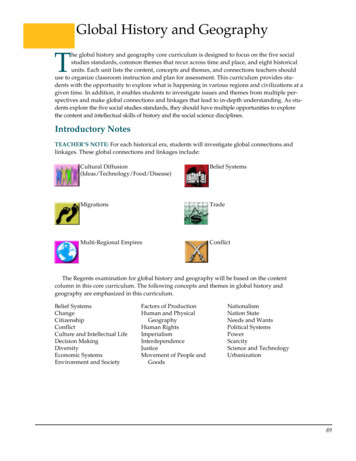
Part IAnswer all questions in this part.Directions (1– 50): For each statement or question, write on the separate answer sheet the number of theword or expression that, of those given, best completes the statement or answers the question.7 Constantinople became the center of theByzantine Empire because(1) the pope had made it the capital of theChristian world(2) it was a religious center for Muslims(3) its location made it the crossroads of Europeand Asia(4) it was geographically isolated from surrounding empires1 Studying oral histories, archaeological evidence,and cultural histories are methods most oftenused by(1) economists(3) philosophers(2) anthropologists(4) political scientists2 When studying ancient civilizations, a geographerwould be most interested in looking at(1) language as a form of expression(2) family structure(3) climatic influences on food production(4) standards for leadershipBase your answer to question 8 on the graph belowand on your knowledge of social studies.Life Expectancy in Medieval England1276–13753 Most traditional societies are(1) closely linked to the natural environment(2) located near large urban areas(3) organized around complex economic systems(4) dependent on manufacturing3530254 One way in which the Huang He, the Indus, andthe Nile civilizations were similar is that theyeach(1) flourished by trading salt and gold(2) developed monotheistic religions(3) suffered repeated invasions(4) originated in river valleysAge2015105 The Code of Hammurabi and the Twelve Tableswere designed to(1) create a stable society(2) promote peaceful relations with other cultures(3) provide a framework for the development ofdemocracy(4) emphasize the importance of life after death50Source: World History Strategies, Glencoe (adapted)8 The principal cause of the trend in Englandshown in the graph was(1) famine(3) immigration(2) disease(4) a lower birthrate6 The terms Brahma, dharma, and moksha aremost closely associated with which religion?(1) Judaism(3) Hinduism(2) Islam(4) animismGlobal Hist. & Geo. – Jan. ’03Before 1276– 1301– 1326– 1351–1276 1300 1325 1350 1375Year of Birth[2]
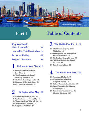
Base your answers to questions 9 and 10 on the map below and on your knowledge of social studies.The Mongol Empire 1300EUROPEASIABLACKSEAMONGOLIA1000 STCHINASEABURMABAY OFBENGALNWHangzhoues RiverINDIAARABIANSEAMongol Empire aboutA.D. 1300av erARABIA0Huang HCHINAGaIndus RiREDSEA1000 kilometersJAPANKOREAeRBaghdadPERSIA0allat Wreiv erGCASPIANSEASOUTHEASTASIAEEAST INDIESSSource: H. Braun, L. Forman, H. Brodsky, Reviewing Global History and Geography, AMSCO(adapted)9 The purpose of the Great Wall was to(1) protect the Chinese from the nomadic tribes of northern and central Asia(2) supply food from the south to Khanbalik (Beijing)(3) control the flood waters of the Huang He and the Chang Jiang rivers(4) protect the port city of Guangzhou10 Which statement is best supported by the information on this map?(1) By 1300, the Mongol Empire had reached the Red Sea.(2) The Mongol Empire controlled India and Japan by 1300.(3) By 1300, most of Europe had been conquered by the Mongols.(4) The Mongol Empire controlled a large portion of Asia by 1300.12 Carefully drawn calligraphy, Zen gardens, andthe tea ceremony are examples of(1) artifacts of Mansa Musa’s Timbuktu(2) the accomplishments of the ProtestantReformation(3) early Japanese culture(4) the achievements of Renaissance Florence11 One way in which the code of chivalry in Europeand the code of Bushido in Japan were similar isthat both codes were intended to(1) help the ruler control his people(2) guide the behavior of a warrior class(3) benefit all the social classes(4) support revolutionary ideasGlobal Hist. & Geo. – Jan. ’03[3][OVER]
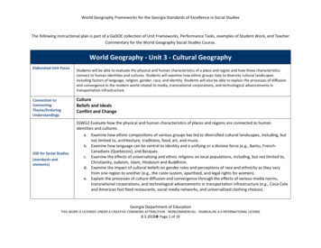
18 The spread of Islam into the kingdoms of Ghanaand Mali resulted from(1) imperialism(3) cultural diffusion(2) ethnocentrism(4) self-determination13 Which heading would be best for the partial outline below?I.A. Desire to be released from feudalobligationsB. Defense of the Holy LandC. Forgiveness of sinsD. Desire for wealth from the Middle East(1)(2)(3)(4)Base your answer to question 19 on the map belowand on your knowledge of social studies.South American Cultures100–1535Reasons for the ReformationEuropean Motives for Fighting the CrusadesCauses of the Fall of the Roman EmpireReasons for the Split Between the Easternand Western ChurchesAndesM14 During the 1500s, technological advances innavigation, naval engineering, and mapmakingcontributed directly to the start of the(1) Gupta Empire(3) Age of Exploration(2) Mongol Empire(4) medieval guildsts.ChanChanMachu 00–700Chimu,1000–1470Inca,1438–1535ountainss MW16 A direct result of the conquest of Tenochtitlán byHernán Cortés in 1521 was the(1) expulsion of Jews and Muslims from Spain(2) establishment of Portuguese trade routesaround Africa(3) fall of the Aztec Empire(4) conquest of the Kush KingdomInca roads00500 mi1000 kmSource: World History: Patterns ofInteraction,McDougal Littell19 Which conclusion about Incan society could bedrawn from the map?(1) An extensive road system connected all partsof the Empire for trade.(2) Their trade depended on many seaports.(3) Tropical climatic conditions existed throughout the empire.(4) A similar language unified the Inca civilization.17 The success of the triangular trade systemdepended on increasing(1) political independence of the Caribbeannations(2) emphasis on free trade in European nations(3) slave trade in the Western Hemisphere(4) industrialization of the South AmericancoloniesGlobal Hist. & Geo. – Jan. ’03An15 The revival of Greek and Roman culture, the economic growth of Italian city-states in the 1400s, andthe development of humanism were aspects of the(1) Age of Revolutions(2) Protestant Reformation(3) spread of Islam(4) European Renaissance[4]
Base your answer to question 20 on the map below and on your knowledge of social studies.Voyages of Zheng He During the Ming Dynasty of diaJiddaArabiaDhufarLa’saAdanTaiwanSiam AnnamBayofBengalCalicutNagappattinamCochinArabian tBorneoofMalaccaIndian OceanEQUATORNWQui NhonChampa naSeaChinaHormuzSumatraPalembangE0S0500 mi500 Studies,VolumeVolume I,I, Asia,Asia, Africa,Africa, andand LatinLatin America,Source:Harriett GellerBarrons EduationalServices,Inc.Barrons EducationalServices, Inc.(adapted)20 Which conclusion can be made about the Ming dynasty of China as a result of thetravels of Zheng He?(1) China profited more from African trade than from Asian trade.(2) Islam became the dominant religion of China.(3) The Ming dynasty established trade routes to Europe.(4) Advanced navigation technology was available in China.23 One similarity of the Scientific Revolution andthe Enlightenment is that both(1) had the support of the Roman CatholicChurch(2) placed great value on traditional beliefs(3) emphasized the value of human reasoning(4) contributed to the end of feudalism21 Which quotation was most likely made by anabsolute monarch?(1) “The government that governs best, governsleast.”(2) “I am the state.”(3) “The government must be based on a soundconstitution.”(4) “It is the parliament that must make the laws.”24 “Americans today, and perhaps to a greaterextent than ever before, who live within theSpanish system, occupy a position in society nobetter than that of serfs destined for labor, or atbest they have no more status than that of mereconsumers. . . .”This quotation, written in September 1815, represents the views of(1) Martin Luther(3) Simón Bolívar(2) Catherine the Great (4) Adam Smith22 The Glorious Revolution in England resulted inthe(1) strengthening of divine right rule(2) formation of a limited monarchy(3) weakening of Parliament’s power of the purse(4) end of civil liberties guaranteed by thePetition of RightGlobal Hist. & Geo. – Jan. ’03[5][OVER]
25 “If man in the state of nature is free, if he isabsolute lord of his own person and possessions,why will he give up his freedom? Why will heput himself under the control of any person orinstitution? The obvious answer is that rights inthe state of nature are constantly exposed to theattack of others. Since every man is equal andsince most men do not concern themselves withequity and justice, the enjoyment of rights in thestate of nature is unsafe and insecure. Henceeach man joins in society with others to preservehis life, liberty, and property.”Base your answers to questions 28 and 29 on the passage below and on your knowledge of social studies.— John Locke, Two Treatises of Government, 1690— Charles Dickens, Hard Times“It was a town of red brick, or of brick that wouldhave been red if the smoke and ashes had allowed it;but as matters stood it was a town of unnatural redand black like the painted face of a savage. It was atown of machinery and tall chimneys, out of whichinterminable serpents of smoke trailed themselvesfor ever and ever, and never got uncoiled. It had ablack canal in it, and a river that ran purple with illsmelling dye. . . .”This statement provides support for the(1) elimination of laissez-faire capitalism(2) formation of government based on a socialcontract(3) continuation of absolute monarchy(4) rejection of the natural rights philosophy28 The author of this passage is describing conditions caused by the(1) Commercial Revolution(2) French Revolution(3) Industrial Revolution(4) Scientific Revolution26 Which 19th century ideology led to the unification of Germany and of Italy and to the eventualbreakup of Austria-Hungary and of the OttomanEmpire?(1) imperialism(3) liberalism(2) nationalism(4) socialism29 Which problem is the subject of this passage?(1) economic inequality(2) urban pollution(3) lack of child labor laws(4) poor transportation systems27 “Famine seems to be the last, the most dreadfulresource of nature. The power of population is sosuperior to the power in the earth to provide subsistence for man, that premature death must insome shape or other visit the human race. . . .”30 The Meiji Restoration in Japan was prompted inpart by(1) a fear that Japan would be colonized bywestern nations(2) the failure of Japanese expansion(3) the Shogun’s conversion to Christianity(4) a desire to stay isolated— Thomas Malthus, “Essay on Population,” 1798This prediction proved to be wrong in partbecause of increases in(1) ethnic cleansing(2) farm productivity(3) the number of wars(4) the number of droughtsGlobal Hist. & Geo. – Jan. ’0331 Growing nationalism and militarism in Europeand the creation of secret alliances were(1) reasons for the rise of democracy(2) causes of World War I(3) requirements for economic development(4) reasons for the collapse of communism[6]
Base your answer to question 32 on the table below and on your knowledge of social studies.Defense Estimates of the Great Powers, 1870–1914(in millions of 452.457.4Great yItalyRussiaSource: A.J.P. Taylor, The Struggle for Mastery in Europe: 1848–1918,Oxford University Press (adapted)32 Which statement is best supported by the data contained in the table?(1) Austria-Hungary could not afford a large military expenditure in 1880.(2) France spent the greatest amount of money on defense in 1900.(3) Germany rapidly increased its military spending after 1890.(4) Great Britain attempted to prepare for a long ground war.33 The Japanese, the Germans, and the Italianspursued a policy of expansionism before WorldWar II to gain(1) natural resources(2) warm-water ports(3) manufacturing plants(4) freedom of the seas35 The Japanese invasion of Manchuria in 1931 andHitler’s rebuilding of the German military in 1935demonstrate the(1) success of defensive alliances(2) fear of communist expansion(3) support for the Treaty of Versailles(4) failure of the League of Nations34 Which statement is most accurate concerning theeffect of geography on the history of Poland?(1) Natural barriers have isolated and protectedPoland.(2) The northern European Plain has madePoland vulnerable to invasion.(3) Mountains have restricted the diffusion ofPolish culture.(4) The absence of seaports has limited Polisheconomic growth36 Which action illustrates the concept of genocide?(1) the British negotiating peace with AdolfHitler during the 1938 Munich Conference(2) Adolf Hitler and Joseph Stalin signing anonaggression pact in 1939(3) the Nazi armies eliminating the Jews andother groups as part of Adolf Hitler’s FinalSolution(4) German generals plotting against Adolf HitlerGlobal Hist. & Geo. – Jan. ’03[7][OVER]
Base your answers to questions 37 and 38 on the map below and on your knowledge of social studies.Member Nations of OPECALGERIAIRAQ KUWAITLIBYAQATARIRANUNITED ARABEMIRATESVENEZUELAECUADORINDONESIANIGERIASAUDI ARABIAGABONMEMBER NATIONS OF OPECSource: Killoran, Zimmer, and Jarret, The Key to Understanding Global History,Jarret Publishing37 According to the map, which region of the world has the greatest number of nationsbelonging to the Organization of Petroleum Exporting Countries (OPEC)?(1) Middle East(3) North America(2) Southern Africa(4) Southeast Asia38 The potential power of the member nations in OPEC lies in their(1) political influence in tropical regions(2) control of access to important religious sites(3) military control over strategic waterways(4) economic influence over industrialized nations39 The purpose of the Marshall Plan was to(1) restore Japanese economic development(2) provide military aid to Middle Eastern allies(3) assure nationalist success in the Chinese civilwar(4) provide for economic recovery in WesternEurope41 Mikhail Gorbachev instituted the policies of glasnost and perestroika to(1) reinforce the basic economic principles ofcommunism(2) bring the Soviet Union into the EuropeanEconomic Community(3) reform the Soviet Union politically and economically(4) gain acceptance for free political elections40 The Truman Doctrine, Korean War, crisis inGuatemala, and Soviet invasion of Afghanistanwere all(1) reasons for the Industrial Revolution(2) examples of Japanese imperialism(3) events of the Cold War(4) causes of World War II42 During the late 20th century, in which area diddeforestation become a serious problem?(1) Great European Plain(2) Amazon Basin(3) Deccan Plateau(4) Great Rift ValleyGlobal Hist. & Geo. – Jan. ’03[8]
Base your answer to question 43 on the graphs below and on your knowledge of social studies.Population and Income of Racial Groupsin South Africa, 1991Asian,3%Asian, 3%Mixed Races, 9%(Colored)White, 16%(British,Boers)Blacks, 72%(Zulu, Xhosa,Sotho, Tswano,others)Populationby Racial GroupMixed Races, 8%(Colored)Blacks, 32%(Zulu, Xhosa,Sotho, Tswano,others)White, 57%(British,Boers)Share of NationalIncome by Racial GroupSource: Killoran, Zimmer, and Jarrett, The Key to Understanding Global History,Jarrett Publising Co.43 The best conclusion that can be drawn from these graphs is that in 1991(1) the Boers outnumbered the British in South Africa(2) the black population has decreased due to emigration(3) Asians controlled a greater proportion of income in comparison to their population(4) whites continued to control the largest amount of income after the end of apartheidBase your answer to question 44 on the statementsbelow that appeared in a newspaper in 1998.45 The problems created by the deterioration of theEarth’s ozone layer and increases in the amountsof acid rain suggest a worldwide need for(1) rapid industrialization of developing economies(2) better health-care programs(3) nuclear-powered electric generating facilities(4) stricter pollution regulations“In response to the nuclear tests, people in NewDelhi took to the streets lighting firecrackers, thanking Hindu gods, and crying out, ‘Bharat Mata Jai!’(Victory to Mother India).”“President Bill Clinton decided tonight to imposeeconomic sanctions on India’s government for detonating three underground nuclear explosions.”46 Since the 1960s, famine in many parts of theworld has been reduced by(1) increased urbanization(2) global warming(3) laissez-faire capitalism(4) the Green Revolution44 Which statement is supported by these two newsexcerpts?(1) India is falling behind in the race to developnuclear weapons.(2) The United States officially supports India’snuclear weapons program.(3) People in India and the United States havereacted very differently to India’s nucleartest.(4) India’s development of nuclear weapons willimprove chances for peace in the region.Global Hist. & Geo. – Jan. ’03[9][OVER]
49 Mahatma Gandhi and Jomo Kenyatta were similar in that both(1) supported colonial policies(2) sought to gain independence from GreatBritain(3) led a worldwide boycott of British goods(4) used violent revolution to achieve their aims47 Which title best completes this partial outline?I.A. Mass starvation in Ireland (1845–1850)B. Partition of India (1947)C. Latin Americans seeking jobs in theUnited States (post–World War II)D. Ethnic cleansing in the Balkans (1990s)(1)(2)(3)(4)50 Sunnis and Shiites have different views aboutwho should lead the Muslim faith. Today some Hindus follow caste rules moreclosely than others do. Most Buddhists belong to one of two mainsects. Christianity is practiced by both Catholics andProtestants.Which generalization is supported by the information in these four statements?(1) In many religions, a range of beliefs oftenexists.(2) A belief in a god is common to all religions.(3) A hierarchy of leadership exists in all religions.(4) Religion is becoming less important topeople.Causes of Global MigrationsCauses of IndustrializationReasons for ColonialismReasons for Cultural Borrowing48 Developments in European HistoryA Protestant ReformationB Feudal PeriodC Industrial RevolutionD Neolithic RevolutionWhich set of events is listed in the correctchronological order?(1)(2)(3)(4)C A B DD C B AB D A CD B A CGlobal Hist. & Geo. – Jan. ’03[10]
Answers to the essay questions are to be written in the separate essay booklet.In developing your answers to Parts II and III, be sure to keep these general definitions in mind:(a) explain means “to make plain or understandable; to give reasons for or causes of; to showthe logical development or relationships of ”(b) describe means “to illustrate something in words or tell about it”(c) evaluate means “to examine and judge the significance, worth, or condition of; to determinethe value of ”(d) compare and contrast means “to express similarities and differences”Part IITHEMATIC ESSAY QUESTIONDirections: Write a well-organized essay that includes an introduction, several paragraphs addressing the taskbelow, and a conclusion.Theme: ChangeThroughout history, political revolutions had many causes. These revolutionsaffected society and led to many changes. The changes may or may not haveresolved the problems that caused the revolutions.Task:Choose one political revolution from your study of global history andgeography and: Explain the causes of the revolution Describe the effects this political revolution had on society Evaluate whether the changes that resulted from the political revolution resolved the problems that caused itYou may use any example from your study of global history, but do not use the AmericanRevolution. Some suggestions you might wish to consider include the French Revolution(1789), Mexican Revolution (1910), Russian Revolution (1917), Chinese Revolution (1949),Cuban Revolution (1959), or Iranian Revolution (1979).You are not limited to these suggestions.Guidelines:In your essay, be sure to: Address all aspects of the TaskSupport the theme with relevant facts, examples, and detailsUse a logical and clear plan of organizationIntroduce the theme by establishing a framework that is beyond a simplerestatement of the Task and conclude with a summation of the themeGlobal Hist. & Geo. – Jan. ’03[11][OVER]
NAMESCHOOLPart IIIDOCUMENT-BASED QUESTIONThis question is based on the accompanying documents (1–8). The question is designed to test yourability to work with historical documents. Some of the documents have been edited for the purposesof the question. As you analyze the documents, take into account the source of each document and anypoint of view that may be presented in the document.Historical Context:The geographic factors of location and availability of resources have affected the history of Great Britain and Japan.Task: Using information from the documents and your knowledge of global history, answerthe questions that follow each document in Part A. Your answers to the questions willhelp you write the Part B essay, in which you will be asked to: Compare and contrast the effect of geographic factors such as location andavailability of resources on the political and economic development of GreatBritain and JapanGlobal Hist. & Geo. – Jan. ’03[12]
Part AShort-Answer QuestionsDirections: Analyze the documents and answer the short-answer questions that follow each document in thespace provided.Document 11800 KilometersBostonNew YorkAtlantic Trade Routes1650–1750germber, ginrs, iron, lufuil,oleWhadsbaccotured gooManufacigo, todin,iceSilk, rWESsesolasar, msug ber,es,mSlav rain, lu lour,gk, fFishivestoclCharlestonSlavesSlaves, molassesMeat, fish, lumber,rum, grainGREAT BRITAINFRANCEfruit1200 Miles0Wine,0BritishColony mT INDIESSlavesSource: Steven Goldberg and Judith Clark DuPré, Brief Review in Global History and Geography,Prentice-Hall (adapted)1 What did Great Britain export along the Atlantic trade routes?[1]ScoreGlobal Hist. & Geo. – Jan. ’03[13][OVER]
Document 2In comparing the advantages of England for manufactures with those of other countries, we can by no means overlook the excellent commercial position of the country— intermediate between the north and south of Europe; and its insular situation[island location], which, combined with the command of the seas, secures our territory from invasion or annoyance. The German ocean, the Baltic, and theMediterranean are the regular highways for our ships; and our western ports command an unobstructed [clear] passage to the Atlantic, and to every quarter [part] ofthe world.Source: Edward Baines, History of the Cotton Manufacture in Great Britain, A.M. Kelly2 Based on this document, identify two ways England has benefited from its location. [2](1)(2)ScoreGlobal Hist. & Geo. – Jan. ’03[14]
Document 3. . .England, however, has grown great in both respects. She is both a great colonialpower and a great industrial power. And she has been fortunate in possessing thenatural conditions necessary to success.For industry and commerce, no less than the command of the seas, are limited bynatural conditions. Modern manufactures cluster round coal-fields, where power canbe had cheaply; the possession of good harbours is essential to maritime trade; a country where broad and gently-flowing rivers act as natural canals will have advantages ininternal communications over a country broken up by mountain ranges. . . . When werecognize that England is rich in these advantages, that she has coal and iron lyingclose together, that her sheep give the best wool, that her harbours are plentiful, thatshe is not ill-off for rivers, and that no part of the country is farther than some seventymiles from the sea, we have not said all. . . .Source: George T. Warner, Landmarks in English Industrial History, Blackie & Son Limited3 According to this document, what are two ways Great Britain has benefited from its geography? [2](1)(2)ScoreGlobal Hist. & Geo. – Jan. ’03[15][OVER]
Document 4The British Empire at Its Height, nIndianOceanSouthAmericaNWBritish Empire00PacificOceanAfricaEAustraliaS2000 miles4000 kilometersSource: Roger Beck and Linda Black et al., World History: Patterns of Interaction, McDougal Littell (adapted)4 What does this map show about the extent of the British Empire in 1910?[1]ScoreGlobal Hist. & Geo. – Jan. ’03[16]
Document 5Cultural Diffusion from China500–1,000 ADKoreaJapanChina5a What effect did Japan’s location have on cultural diffusion from China?[1]Scoreb Identify one cultural contribution to Japanese society that came from China.[1]ScoreGlobal Hist. & Geo. – Jan. ’03[17][OVER]
Document 6. . .The geographical features of Japan have much in common with those of ancientHellas [Greece]. In both there is the same combination of mountain, valley, and plain,[and] a deeply indented coastline, with its bays, peninsulas, and islands off the coast.Few places inland are far removed from the mountains, and none are really distantfrom the sea. . . .The land was on all sides well protected, and yet also open to the sea; and in eachcase, too, there was free access for commerce and civilisation from early times. . . .The deeply indented coastline of Japan provides a number of excellent harbours onthe Pacific coast, and its shores abound in fish of all kinds, the rich supplies of whichhave for centuries constituted one of the chief articles of food of the people. The fishing industries have helped to provide Japan with a recruiting-ground for one of thestrongest and most formidable navies of modern times. . . .Source: Walter Weston, “The Geography of Japan in Its Influence on the Character of the JapanesePeople,” in The Japan Society of London, Transactions and Proceedings, XX (1922–1923)6 Based on this document, identify two ways geography affected the development of Japan.[ 2](1)(2)ScoreGlobal Hist. & Geo. – Jan. ’03[18]
Document 7. . .The [Meiji] Restoration found Japan [1868–1912] practically an agricultural country, purely and simply. There were few, if any, industries of importance. The agriculturists [farmers] produced sufficient food to supply the nation, and Japan was in everysense self-supporting. Even the taxes were paid in rice, and farmers were ranked farhigher than merchants. History showed the Japanese, however, that it is very difficultto maintain a high standard of national greatness when the revenue of the land and theprosperity of the people depends absolutely upon the fall of rain or the hours of sunshine. . . .Besides the necessity, there was an additional reason to be found in the knowledgethat industrial growth would add enormously to the power of the nation, not only inthe Far East, but among European countries. It was recognized that industrial andcommercial development was a much surer guarantee of greatness than militarypower, and that the conquest of markets was more efficacious [effective] than thedestruction of armies and navies. In this proficiency Japan desired to be the Englandof the East . . . .Source: Alfred Stead, Great Japan: A Study of National Efficiency, John Lane Company7a Identify one feature of Japanese economic life before the Meiji Restoration.[1]Scoreb Identify one way in which the Meiji Restoration changed economic life in Japan.[1]ScoreGlobal Hist. & Geo. – Jan. ’03[19][OVER]
Document 8Japan’s Expanding Empireto 1934120º E130º E140º E150º ESOVIET UGUO)Vladivostok40ºNBeijingSea of JapanPort Arthur KOREAPacificOceanJAPANYellowSeaTokyoOsakaN30º NEWRYUKYUIS.CHINA0TAIWANHong Kong(Br.)S0300600 Miles300 600 KilometersJapan1890Territoryaddedby 1918Territory addedby 1934MainmanufacturingareasBauxiteCopperIron oreCoalGoldPetroleumSource: Elisabeth Gaynor Ellis and Anthony Esler,World History Connections to Today:The Modern Era, Prentice-Hall (adapted)8 Based on the information provided by this map, state one reason Japan would want to acquire Korea andManchuria. [1]ScoreGlobal Hist. & Geo. – Jan. ’03[20
Source: World History Strategies, Glencoe (adapted) Life Expectancy in Medieval England 1276-1375 Age Year of Birth Global Hist. & Geo. -Jan. '03 [2] . Source: World History: Patterns of Interaction,McDougal Littell South American Cultures 100-1535 Global Hist. & Geo. -Jan. '03 [4]