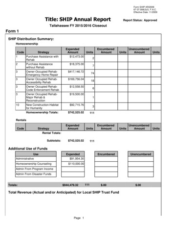
Transcription
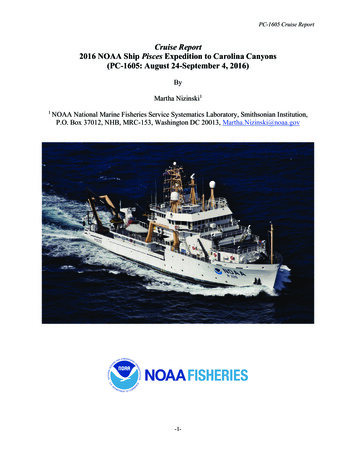
PC-1605 Cruise ReportCruise Report2016 NOAA Ship Pisces Expedition to Carolina Canyons(PC-1605: August 24-September 4, 2016)ByMartha Nizinski11NOAA National Marine Fisheries Service Systematics Laboratory, Smithsonian Institution,P.O. Box 37012, NHB, MRC-153, Washington DC 20013, Martha.Nizinski@noaa.gov-1-
PC-1605 Cruise ReportIntroductionSubmarine canyons continue to be areas of high interest to federal and state agencies tasked withresearch and management responsibilities, particularly those for deep-sea corals. Most canyonsare poorly known, but based on data collected during previous investigations, many scientistsand managers believe submarine canyons provide refuge for a variety of fauna including corals,fishes, and other animals.Beginning on August 24, 2016, a multidisciplinary team of scientists and engineers (Table 1),aboard NOAA Ship Pisces spent 12 days-at-sea exploring three deep-water canyons off the coastof North Carolina. Specifically, the team targeted Keller, Pamlico, and Hatteras canyons.With the overall goal of surveying suspected deep-sea coral habitats associated with thesecanyons using the AUV Sentry, the primary objectives for this mission were to:1. survey canyon and inter-canyon slope environments to characterize benthic habitats andidentify areas of coral presence;2. conduct multibeam mapping in canyon and slope areas where data are missing orincomplete;3. assess geological features to characterize canyon morphology;4. conduct CTD sampling; and5. collect water samples and monocore samples during specific CTD casts.This cruise marked the first of several missions scheduled to take place off the Southeast U.S.with the aim to collect contemporary scientific information needed by managers to protect andconserve deep-sea coral ecosystems. Several NOAA line-offices (National Marine FisheriesService, Office of Ocean Exploration and Research, National Ocean Service), other governmentagencies (Bureau of Ocean Energy Management, U.S. Geological Survey), and regional resourcemanagers are interested in deep-sea coral habitats in this region.Narrative of cruise resultsDespite numerous challenges, the research team was able to address each of our objectives.Objective 1. The research team completed three AUV dives between 700 and 1900 m depth, for atotal of 50 hours of bottom time covering 71 km distance over ground (Table 2). Strong surfacecurrents (4 knots) prevented the science team from surveying Keller Canyon. Further south andoutside the direct influence of the Gulf Stream, AUV Sentry completed one successful dive inPamlico Canyon and two successful dives in Hatteras Canyon (Figures 1-3). Based on thepreliminary analysis of the 50,000 collected images, the team documented the presence ofdeep-sea corals and sponges in both of these canyons (Figures 4-5). Additionally, a variety offishes, crustaceans and cephalopods were observed in many of the images. Furthermore, AUVSentry collected optical backscatter, oxidation-reduction potential (ORP), dissolved oxygen andtemperature data along the imaging path (Figure 5).Objective 2. The research team mapped the head of Hatteras Canyon using the ship’s ME70multibeam system to generate maps of bathymetric features. Although numerous mapping-2-
PC-1605 Cruise Reportpriority areas were identified, the ME70 was nonfunctional for the majority of the cruise. AUVSentry, outfitted with sidescan sonar, collected bottom profile data during the three imagingdeployments.Objective 3. Images revealed a variety of habitats, including smooth canyon walls and flatsedimented plains. The morphology, and presumably the underlying geology, of these twocanyons are quite different then that observed in canyons further north.Objective 4. AUV Sentry collected CTD data during all imaging deployments (Figure 5).Additionally, seven CTD-Niskin casts were completed during the mission. Three casts weremade at the Cape Fear landslide site; the remaining four casts collected water column data alongthe axis of Hatteras Canyon (Table 3).Objective 5. Water and monocore samples were collected during seven CTD casts (Table 3). Aseries of four core samples, taken along the axis of Hatteras Canyon, was collected at depthintervals comparable to those sampled in nearby Norfolk and Baltimore canyons. These cores,sectioned into layers, resulted in 74 samples. Additionally, 56 liters of water were filtered whileat sea. Analyses of these sediment and water samples will provide information on the amount,composition, and quality of food available to benthic organisms living in the canyonenvironment. Further processing of these samples for isotope analyses will be conducted bypersonnel at USGS in Gainesville, Florida.Due to poor weather conditions (tropical depressions passing through the study area) the shiptraveled further south, outside the original study area. At this southern, more inland location, thescience team collected three core samples at a landslide area off Cape Fear to support researchinterests of USGS colleague, Jason Chaytor. Analysis of these core samples will furtherunderstanding of sediment flows as well as provide better estimates of the timing of recentunderwater landslides. These samples were shipped to J. Chaytor (USGS, Woods Hole, MA) forprocessing.OutreachThis cruise, designated a NOAA Office of Ocean Exploration and Research signature cruise, washighlighted on the OER /16carolina/welcome.html.Daily logs were posted while at sea. At-sea scientists engaged with students in North Carolinaand Florida as well as answered questions posted to the website. Cruise highlights were alsolinked to the North Carolina Museum of Natural Sciences.-3-
PC-1605 Cruise ReportParticipant listTable 1. List of participants of 2016 expedition to the North Carolina Canyons aboard theNOAA Ship Pisces (PC-1605).NameMartha NizinskiAmanda DemopoulosElizabeth SheaElizabeth BairdKatie WagnerShelby BowdenWilliam HefnerCarl KaiserMichael McCarthyJustin FujiiZachary BerkowitzMolly CurranRoleChief ScientistScientistScientistScience EducatorWeb CoordinatorScientistScientistAUV Sentry team leadAUV Sentry teamAUV Sentry teamAUV Sentry teamAUV Sentry teamAffiliationNOAA National Marine Fisheries ServiceUnited States Geological SurveyDelaware Museum of Natural HistoryNorth Carolina Museum of Natural SciencesNOAA Office of Exploration and ResearchCollege of CharlestonCollege of CharlestonWoods Hole Oceanographic InstituteWoods Hole Oceanographic InstituteWoods Hole Oceanographic InstituteWoods Hole Oceanographic InstituteWoods Hole Oceanographic Institute-4-
PC-1605 Cruise ReportTable 2. Dive summary table for three AUV Sentry dives conducted during the 2016 expedition to the North Carolina Canyons aboardthe NOAA Ship Pisces (PC-1605). Note that the dive number corresponds to the number assigned by the AUV Sentry ngitudeEnd time(h:min)2016/8/28 12:36:13 34.964152016/8/31 12:54:12 35.289722016/9/1 23:08:41 8334.4823.60Table 3. Inventory of CTD casts conducted during the 2016 expedition to the North Carolina Canyons aboard the NOAA Ship Pisces(PC-1605).LocalityCape FearCape FearCape atitude th (m) 734.99934.98535.04935.04635.06835.004
PC-1605 Cruise ReportFigure 1. Map showing the locations of the three AUV dives and seven CTD casts conducted during the 2016 expedition aboard theNOAA Ship Pisces (PC-1605).-6-
PC-1605 Cruise ReportFigure 2. Dive tracks of the three AUV Sentry dives conducted during the 2016 expeditionaboard the NOAA Ship Pisces (PC-1605) including (top) dive 391 in Pamlico Canyon, and(bottom) dives 392-393 in Hatteras Canyon. 100 m contour lines are shown in black.-7-
PC-1605 Cruise ReportFigure 3. Bottom images taken by AUV Sentry in Pamlico Canyon during 2016 expedition aboard the NOAA Ship Pisces (PC-1605).-8-
Figure 4. Bottom images taken by AUV Sentry in Hatteras Canyon during 2016 expedition aboard the NOAA Ship Pisces (PC-1605)-9-
Figure 5. Time series plot of environmental data collected by AUV Sentry sensors during dive 391 in Pamlico Canyon. Plots arerepresentative of the environmental data collected during the three AUV dives conducted during the expedition. From top to bottom:temperature, salinity, optical backscatter, dissolved oxygen, and oxidation-reduction potential (ORP).-10-
PC-1605 Cruise Report -1- Cruise Report . 2016 NOAA Ship . Pisces. Expedition to Carolina Canyons (PC-1605: August 24-September 4, 2016) By . Martha Nizinski1. 1 NOAA National Marine Fisheries Service Systematics Laboratory, Smithsonian Institution, P.O. Box 37012, NHB, MRC-153, Washington DC 20013,