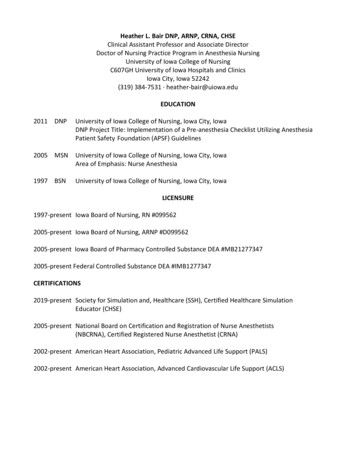
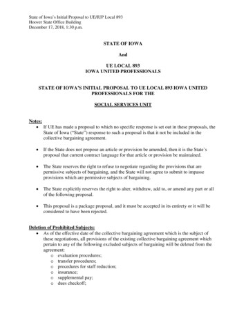
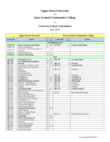
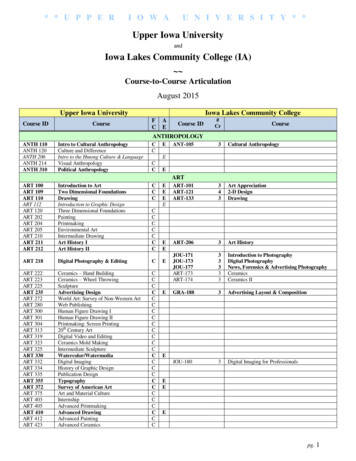
Transcription
9/5/2007LiDARin IowaOur experience dabbling with Lidar.Five watersheds flown in 2005Update 08/08/07Jim Giglierano, Chris Ensminger, Pete Kollasch,Andy Asell, Chris Kahle, Casey Kohrt,Mary Howes and Calvin WolterIowa Department of Natural ResourcesGIS SectionIowa Geological SurveyLiDAR in Iowa 2005Iowa Geological SurveyThis is your brain on NED . Five watersheds flown in spring 2005 Over 1 per acre (including breaklines,“high-accuracy” DEM and 2’ resolutioncolor orthophotos) 1 meter postings 15 cm RMSE vertical accuracy (nonvegetated surfaces)Iowa Geological SurveyThis is your brain on Lidar .!Iowa Geological SurveyLiDAR in Iowa? Contract price: 75 75-- 85 per sq. mile (11to 13 cents/acre) for large acquisitions –Iowa 56,000 sq. milesIowa Geological SurveyIowa Geological Survey1
9/5/2007Instead of a 20 million projectfor the whole state,it became a 4 million projectLiDAR in Iowa!!! USGS 2005 CSCCSC-2 contract with Sanborn– Productized LiDAR: FEMA, Standard, HighHigh-res– FEMA and Standard Product Specs: We can do that!Iowa Geological Survey1.4 m postings18.5 cm RMS @ 95% confidence37 cm RMS in vegetation1mhhorizontalit l RMS @ 95% confidencefid95% of vegetation: FEMA product; (90% - Standard product)90% artifacts: FEMA; (89% - Standard)95% outliers: FEMA; (90% - Standard)98% of buildings removed: FEMA Product; (95% - Standard)– Deliverables: ASCII x,y,z,i text files; LAS all returnbinary filesIowa Geological SurveyLiDAR in Iowa!!!What makes FEMA Product special?Standard Product– Groundtruthing is performed– GPS baseline 20 km (standard product40km)– Manual Processing to remove extras: FEMA Compliant Product95% of vegetation90% of artifacts95% ofoutliers98% of buildingsIowa Geological SurveyIowa Geological SurveySo you want some breaklines, eh?Our DEM hillshade plus breaklines from photogrammetryIowa Geological SurveyHillshade made from breakline DEMIowa Geological Survey2
9/5/2007Breakline DEM hillshade and 2’ contoursFunding LiDAR in Iowa?!?Iowa Dept. of Transportation - 1.5MIowa Dept. of Agriculture and LandStewardship - .57MIowa State Office of USDA NRCS - 1MIowa Dept. of Natural Resources - 1.23MTotal 4.3 M*Use of State Revolving Loan Fund for WaterQuality to make payments easierIowa Geological SurveyIowa Geological SurveyLiDAR in Iowa! Full state Lidar acquisition spread over 2 years Lidar products for 19 counties will meet FEMAflood plain mapping guidelines; 80 counties willbe standard product Acquisitionqstarted in fall/winter 2006,,continuing spring and fall/winter of 2007,probably finish up in spring 2008 Avoid leafleaf--on conditions (May through October) Avoid snow and flood watersIowa Geological SurveyIowa Geological SurveyLiDAR in Iowa LiDAR Products for Iowa Delivery starts after a “lot” is completed– may get first lot this fall USGS has 60 days to accept product –USGS will provide some QA/QC “Raw” data will be free and available tothe public via ftp server as soon aspossible Product delivered as 2 x 2 km tiles(36,424 tiles in state!) Each tile will have around 1.5 milliondata points Deliverable 1: ASCII text files withBARE EARTH x,y,z,i 2 TB total Deliverable 2: binary LAS format fileswith all data and returns (first, last, bareearth, intensities, classifications) 3 TBIowa Geological SurveyIowa Geological Survey3
9/5/2007LiDAR USERS in IowaDerived GIS products 20 TB Most users want X,Y,Z data for CAD– IDOT and County engineers– NRCS and IDALS conservation technicians– IDNR land acquisition and engineering GIS users want various products: DEMs,contours, slopes, shaded relief, structuresand vegetation – estimate about 2 years tobuild DEMs and derived productsIowa Geological SurveyWe estimate that a county size’s worth of elevation data setcan be built in about a week of processing raw lidar datausing terrain models in ArcGIS 9.2 – include BE, FR, LRIowa Geological SurveyArcGIS 9.2 Workflow Starts with ASCII x,y,z,i 2x2 km tiles Run Python script to create huge x,y,z filefrom many tiles (if needed, run CORPSCONto change projection and units) Run Modelbuilder script to import x,y,z points,build terrain, create DEMs, shaded relief, andcontours Or run a Modelbuilder script to start with theLAS files, directly extract points, buildterrains, DEMs, etc.Iowa Geological SurveyA County’s Worth of Lidar Data Estimate there will be about 500-600 million elevationpoints – these will be processed into: An ArcGIS 9.2 terrain feature set in a filegeodatabase A 1.0 meter bare earth DEM and shaded relief imagep ggrid from the DEM A slope 2’ contours from the DEM A 1.0 meter first return DEM and shaded relief image Calculate first return and bare earth difference to getheight of trees and buildings First return and bare earth intensity images to recordground conditions at the time of lidar acquisition 50 Gigabytes of storage space neededIowa Geological SurveyIowa Geological SurveyHow CAD folks might work with lidardata from the statewide project Download ASCII x,y,z,i 2x2 km tilesfrom ftp server or web application Run free CORPSCON program tochange projection and format Load x,y,z files into CAD program Create TINs, grids and contours Save lots of time and money Boss is happy, give you big raise!Iowa Geological Survey4
9/5/2007What’s one of the best uses of Lidar elevation data?Mapping really flat land Iowa Geological SurveyIowa Great Lakes Lidar Project2002 Color-infrared airphotoIowa Geological SurveyIowa Great Lakes Lidar Project30 meter NED hill shadeIowa Geological Survey1 meter Lidar DEM hill shadeIowa Geological SurveyNED hill shade close up at 1:24kLidar elevation incolor over shadedreliefIowa Geological SurveyIowa Geological Survey5
9/5/2007Ice walled lakes in SiberiaLidar DEM hill shadeIowa Geological SurveyIowa Geological SurveySpring Run Wetland ComplexA not so flat place in western Iowa –The Loess HillsIowa Geological SurveyIowa Geological Survey30 meter NED DEM hill shade at 1:24kLoess Hills:lidar data fromPottawattamie CountyGIS Department- thanks David Bayer!Iowa Geological SurveyIowa Geological Survey6
9/5/20078’ Lidar DEM hill shadeIowa Geological SurveyMissouri River floodplain by LidarIowa Geological Survey“Hungry canyons” and mining loess for fillfor Omaha and Council BluffsIowa Geological SurveyMissouri River floodplain by NEDIowa Geological SurveyLoess Hills: wind blown silt up to 100’ thickIowa Geological SurveyScott Co GIS Department lidar data:- thanks Ray Weiser!Iowa Geological Survey7
9/5/2007Sand dunesVisit BeautifulScott County!Iowa Geological SurveyNew Lidar!Collected Dec.2006Iowa Geological SurveyNED 10 meter – shaded reliefAllamakeeCountyIowa Geological SurveyAdd the 1 meter LidarIowa Geological SurveyIowa Geological SurveyNED with GPSed sinkholesIowa Geological Survey8
9/5/2007NED 10 meterZoom in to center – 1:24k scaleIowa Geological SurveyNED 10 meter - zoom in furtherIowa Geological SurveyHere it is on the 2006 color NAIP airphotoIowa Geological SurveyOverlay the 1 meter LidarIowa Geological Survey1 meter Lidar – now that’s betterIowa Geological SurveyLet’s look at this little sinkholeon the lidarIowa Geological Survey9
9/5/2007Same sinkhole from the groundIowa Geological SurveyLet’s look at another sinkhole areaIowa Geological SurveySubtle sinkhole about 6’ deepIowa Geological SurveyAnd this little sinkhole is about 10’ deepIowa Geological SurveyVery subtle sinkholesIowa Geological SurveyArcHydro – sinkhole catchmentsIowa Geological Survey10
9/5/2007Using LAS binary data – all returnsIowa Geological SurveyTrees and sinkholesIowa Geological SurveyReclassification of LAS PointsIowa Geological SurveyTrees and sinkholesIowa Geological SurveyTrees and ravinesIowa Geological SurveyOnce more – NED 10 meterUpper Iowa River valleyIowa Geological Survey11
9/5/20072’ pixel, four-band 1:400’ orthoimageryLidar - 1 meterLyon, Sioux, Osceola, O’Brien, Taylor, Adams, Ringgold, Union, Clarke, Decatur,Mahaska, Keokuk Counties may be in the first delivery – this fall?Iowa Geological SurveyEnough about us Iowa Geological SurveyIowa Geological SurveySo now what?Iowa Geological SurveyQuestions?Common reactions tothis presentationAnswers .Iowa Statewide Lidar Program POC:Chris Ensminger(515)281-4216 chris.ensminger@dnr.state.ia.usLidar techical program:Chris Kahle(319)335-1583 chris.kahle@dnr.iowa.govPete Kollasch(319)335-1578 pete.kollasch@dnr.iowa.govJim Giglierano(319)335-1594 james.giglierano@dnr.iowa.govIowa Geological SurveyIowa Geological Survey12
LiDAR Products for Iowa Product delivered as 2 x 2 km tiles (36,424 tiles in state!) Each tile will have around 1.5 million data points Iowa Geological Survey Deliverable 1: ASCII text files with BARE EARTH x,y,z,i 2 TB total Deliverable 2: binary LAS format files with all data and returns (first, last, bare