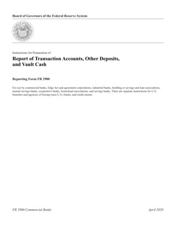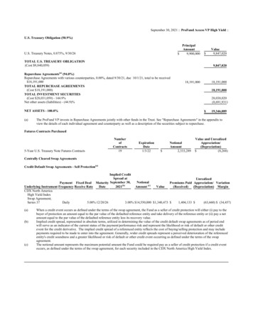
Transcription
Banks - History of Martha's VineyardCharles Edwards Banks. 1911. THE HISTORY OF Martha's Vineyard DUKES COUNTYMASSACHUSETTS, IN THREE VOLUMES. BOSTON. PUBLISHED BY GEORGE H. DEANDecember 19, 2011[Volume on the Internet Library downloaded 1554 times]" Heel of the Cape” between 70 27' 24" (Cape Poge light) and 70 50' (Gay Head light) west longitude;and 41 18' 04" and 41 28' 50" (West Chop light) north latitude19 1/4 miles E-W; N-S 9 3/8; about 100 miles square; 64,000 acres of landThe narrow gut which divides Chappaquiddick is not always a constant condition, as it has been closed atits lower opening within the memory of the living. It is probable that Chappaquiddick was once a part ofthe Vineyard, and the name given to it by the natives "the Separated Island"—may indicate that in theirtraditional knowledge the breach between the two was made by the action of the waves and storms. Norare these the only changes of importance in the progress of the ages ; for it is regarded ascertain "thatMartha's Vineyard has been connected with the mainland since the close of the glacial period. Theanimals and plants of the island are in no way peculiar. We can hardly believe," says our authority, "thatseveral large-seeded plants and many of the land animals have found their way across the five miles ofwater which separates the Vineyard from the continent."Nantucket is practically devoid of trees, while the greater part of the Vineyard is forest-clad, and in 'Thechannel of Vineyard Sound does not exceed seventy-five feet in depth. General and Statistical earlier daysundoubtedly had a much heavier growth than at present.Four glacial deposits: Gay Head plateau, which rests on a bed of tertiary clay; frontal moraine hills onthe north shore between Tashmoo and Menemsha marked by the depositionof countless massive blocks of syenite, so numerous "that on the steeper parts of the hills the bare massesof angular fragments remind the observer of Cyclopean masonry."; third the kames, from a Scotchword signifying a comb the drifts on the eastern shore of Lagoon pond, on Chappaquiddick and on thenortheast shore of Tashmoo pond. T detrital material having irregular depressions or valleys as a resultof swift currents of sub-glacial streams cutting through them. The last, or terrace drift, composes the great"Ragged Plain" sloping southward with gentle undulations to the sea, a formation better shown on thisisland than in any other part of New England.Erosion - The late Professor Henry L. Whiting estimated the recedence on the south beach at about twohundred feet, at Nashaquitsa cliffs two hundred twenty feet, and at Chilmark pond, one hundred eightyfeet in a period of forty years covering his work in the coast survey. In addition to this, what he terms the"overshot" into the ponds on that side represents encroachments greater than the effects of normal seadash, amounting to between five and six hundred feet in the Chilmark and Tisbury ponds. Inconsequence of this, a group of small ponds connecting the Great Herring pond with Katama bay havebeen obliterated. This included the Crackatuxet pond of the first settlers. The tip end of Chappaquiddickon which the lighthouse now stands was once an island known early as Capawack and later as Natuck. Itwas doubtless connected by the great storm of 1722, which also closed an opening into Pocha pond."' Thewhole eastern fringe of Chappaquiddick was probably an outer bar of beach separated from the rest of theisland. From analogy and historic references it can be inferred that Squipnocket pond was open to the seaon the south after the settlement by the whites. A document dated 1694 refers to the neck of land joiningGay Head to Chilmark, where the main road now runs, as "the place where the casks were rolled over out1
of one into the other pond when a shippe was left on the south side of the island." The presentdrawbridge on the "Beach road" connecting Cottage City, spans an opening into Lagoon pond which wasmade about sixty years ago. The original opening was at the western end of the beach, adjoining VineyardHaven, and the ferry to Woods Hole in early days found its harbor inside the opening. Similar phenomenahave been observed at the south opening of Katama bay in very recent years, and the changes in that stripof beach due to sea-dash have been frequent and striking. The north side of the island has suffered less,but both East and West Chops have shown considerable erosion, and within the past decade the generalgovernment has fortified these two points by jetties and riprap to prevent further loss and the shoaling ofVineyard Haven harbor.The minimum temperature rarely goes to zero—about once each season—and remains only a few hours atmost. It does, however, go below 32 on an average of 86 times each year.Dense fog prevails on thirty-five days of the yearthere are 230 days without frost, while the other parts of the state only enjoy from 140 to 160. [Same asACK]Once or twice in a generation the harbors and the surrounding waters will be frozen enough to preventnavigation, as in the recent winter of 1905. The winter of 1856-7 is also remembered by the olderinhabitants as one of such severityReferring to Brereton: “The only vegetable mentioned by him are Peas, "which grow in certeine plots allthe Island over." It seems certain that he failed to observe the other legume, cultivated by the natives, thebean,' and it is quite probable that, had he gone into the interior of the Vineyard, he would have foundfields of corn, and squash vines trailing through them. Corn was pre-eminently the Indian's cereal, calledby him "weatchimin," and our word "succotash" is derived from their term " msickquatash " which meansliterally, corn beaten in pieces.”Of the trees mentioned in Brereton's list, the cypress has disappeared if there be any hazelnut or"cotton" trees on the island at present, they are unknown to the author .The cedar, also, has practicallyvarnished, and only gnarled and bent specimens survive as the relics of "tall and straight" ones seen bythe first explorers.the great plain land is a dense jungle of the "scrub oak" which thrives despite repeated devastating firescovering large areas. Professor Shaler states that "originally this region was heavily wooded, mainly withconiferous trees, the present prevalence of the deciduous species being due to the peculiar endurance oftheir roots in the fires, a capacity which does not exist in the conifers."Brereton is our first authority on the fauna of the Vineyard, although we cannot be sure that he has notincluded in his lists some animals seen by him on the mainland only two which can be said to existtoday, the fox and rabbit.The list of birds would not be complete without special mention of the heath-hen or pinnated grouse,which has been on the island for at least a century. It was probably brought here for breeding as a gamebird, and in 1824 laws for its protection were passed by the voters of Tisbury, where it is found to-day inits feeding grounds on the plains. A cock, hen, and their young may frequently be seen from the statehighway in that town. [Footnote: 'It is traditional that when an effort -n-as made in the State Legislature tosecure a law for the protection of the heath hen, an error of the printer in the title of the bill made it read "An Act for the protection of the Heathen of Martha's Vineyard."]2
Oysters have practically disappeared, but at one time must have been plenty in the ponds bordering thesouth beach. Indeed, one of them is named Oyster pond, presumably because of its being one of theprincipal places where the beds existed.PopulationFrom 1 64 1 to 1670, the period elapsing between the first settlement at Great Harbor and the beginningof the new town at Takemmy, the entire English population was resident at the east end of the island.1742 - about twelve hundred persons resident in the county, exclusive of negroes and native aborigines.1762 – 2460 whites; 46 Negros; 313 Indians; 328 housesIndiansThere were large, open spaces, overgrown with grass and planting fields which they had cultivated forcenturies. Wood in his New England Prospect (1634) speaks of the Indian custom of burning the groundeach fall: "there is no underwood save in the swamps and low places; for it being the custom of theIndians to burn the woods in November, when the grass is withered and the leaves dried it consumes allthe underwood and rubbish." Morton refers to the same thing, and we can readily believe their statementsthat on the coming of the English to this coast there were open fields covered with grass. It is a fairpresumption that the Vineyard presented a general aspect of fresh verdure to the explorers, for its virginsoil had not been exhausted by the improvident whites, nor its groves of beeches, cedars, and firsdenuded The hills and meads of the island were clad in a rich covering of evergreen that is now all gone, and itsplace taken by the walnut and hickory and the endless prospect of dwarf oaks that now struggle for aparched existence on the great plains of Tisbury and Edgartown. It is difiicult for us to conceive ofNoman's Land, which is now as innocent of any foliage as an infant's poll, once supporting great forestsand a thicket of undergrowth, yet in two centuries the whites, without forethought or wisdom, haddespoiled it of its verdure and rendered it an unproductive, barren isle, where for centuries the aboriginaloccupants had preserved its fertility and the productiveness of the Vineyard, sparing the trees as a part ofnature's household economy. On Noman's Land, in the swamp, may be seen the trunks and stumps ofhuge cedars, the decaying remains of a noble forest growth that existed two hundred years ago.The aboriginal name for the island was Noe-pe 1, a compound term consisting of the radical Noe,signifying, middle of, midst, amid, and the generic -pe, which in all Algonquian dialects signifies"water,"—and thus we have the full and free definition "amid the waters," a name of singular beauty andpoetry. While this might be said to be applicable to any island, yet it appears to have a deepersignificance.[The Indians]: noted that this island was at the meeting place of the currents coming from the northeastand southwest. This phenomenon, now well known to the residents here and to all those engaged innavigating our coast, results in a subdivision of the daily tides, by which we have four instead of two ascommon elsewhere along the New England littoral, two ebb and two flood, churning northeastwardthrough the Vineyard sound and Buzzard's Bay and southwestward over the treacherous Nantucketshoals. "The region about Martha's Vineyard," says a report of the U. S. Coast Survey, "is the dividingspace between the co-tidal hours of XII and XV, and in this locality the combination of two apparentlydistinct tidal waves is observed. This combination presents the most singular forms, giving at times fourhigh tides in one day near the junction of Nantucket and Martha's Vineyard sound. These tides exhibitdiurnal and semi-diurnal elements. The semi-diurnal waves exhibit two heads at the locality of thegreatest interference (Falmouth), one of their meeting points."1Banks attributed this to a letter by Rev. Thomas Mayhem Oct.322, 1652
Smith, Winslow, Wood, Gorges, and others, call it the Isle of CapowackThe evolution of the name Cape Poge is easy of demonstration. The name was originally, as I believe,Capoag or Capoak, and by giving each vowel its syllabic value in pronunciation, we have Capo- ag, orCa-po-ak, which was, probably, an Indian name of a definite locality; and the early voyagers, hearing thispronounced and noting the phonetic resemblance of the first syllable to our geographical word "cape,"immediately applied it to that portion of the island answering the physical features of a cape, and the mapmakers accordingly registered their decrees. DeLaets map of 1630, showing the Vineyard, we see thelegend "C. Ack," or Cape Ack DesBarres chart of 1781 it is Capoag (one word)From all evidence now obtainable the tip end of Chappaquiddick was a separate island two hundred yearsago, and was then called the island of Natuck or Capoag, as shown by the following deeds: I. 388.Pahkepunnasso, sachem of Chappaquiddick, sold the island called Natuck to Thomas Mayhew, 16 (6)1663. IV. 158. Micajah Mayhew leased "the island of Natick alias Capoag near unto Chappaquiddick," 4March, 1727. IV. 328. Micajah Mayhew leased the "Isle of Capoag . which lieth a Uttle to the EasterNorthard of the Isle of Chapaquidet" 27 February,1729The Vineyard was apparently divided into four governmental sections, of which two, Chappaquiddick andGay Head, were separated by natural boundaries from the main island .By a straight line drawn from theBlackwater brook emptying into the sound, to Watchet, the sachemships of Nunnepog and Takemmywere divided These sachems were not always natives of the Vineyard, but in what manner they acquired their rank andentered into the enjoyment of their prerogatives is not known,—probably by selection of the mainlandchiefs.Indeed, Brereton found them in 1602 speaking some English, if we may credit his roseate view of all thethings he saw. He said: They pronounce our language with great facilitie; for one of them one day sittingby me, upon occasion I spake smiling these words: "How now (sirha) are you so fancie with my Tobacco;which words (without any further repetition) he suddenly spake so plaine and distinctly, as if he hadbeene a long scholar in the language.'The following legend relates to the beginnings of the aboriginal life upon the Vineyard: "The first Indianwho came to the Vineyard was brought thither with his dog on a cake of ice/ When he came to Gay Headhe found a very large man, whose name was Moshup. He had a wife and five children, four sons and onedaughter, and lived in the den. He used to catch whales, and then pluck up trees, and make a fire and roastthem. The coals of the trees and the bones of the whales are now to be seen. After he was tired of stayinghere, he told his children to go and play ball on the beach that joined Nomans Land to Gay Head. He thenmade a mark with his toe across the beach, at each end, and so deep that the water followed and cut awaythe beach; so that his children were in fear of drowning. They took their sister up and held her out of thewater. He told them to act as if they were going to kill whales, and they were all turned into killers (a fishso-called). The sister was dressed in large stripes; he gave them a strict charge always to be kind to her.His wife mourned the loss of her children so exceedingly that he threw her away. She fell upon Seconnett,near the rocks, where she lived some time, exacting contribution of all who passed by water. After awhileshe was changed into a stone. The entire shape remained for many years, but after the English came someof them broke off the head, arms, &c, but the most of the body remains unto this day. Moshup went awaynobody knows whither. He had no conversation with the Indians, but was kind to them, by sendingwhales &c ashore to them to eat. But after they grew thick around him he left them." Mass. Hist. Soc.Coll., I, 139.4
Another tale which has come down to us from the Vineyard Indians is as follows: "One day he decided togo to Cuttyhunk, which was but a few strides for one so famous as he, but he did not wish to get his feetwet, and taking some stones in his apron he began laying the foundations of a bridge. While engaged inthis absorbing occupation a monster crab bit his toe and firmly held that member in its great claw, whichcaused Michabo to roar with pain, and in his anger he threw his load in every direction in his efforts torelease himself. The rocks thus scattered mark the place now called the "Devil's Bridge," a fateful spot formariners. On another occasion an offering was made to him by his subjects of Nope, of all the tobacco onthe island, and filling his great hopuonk or pipe, he sat down in front of his "den" and enjoyed this hugesmoke. After taking his fill of this diversion, he turned over the bowl and knocked the ashes from it, andas they were carried by the wind to the eastward, they fell in a heap and formed the island of Nantucket,which was known as the Devil's Ash Heap by the natives."'"The natives of the Elizabeth Island say that the Devell was making a stone bridge over from the main toNanamesit Island, and while he was rowling the stones and placing them under water, a crab catched himby the fingers, with which he snatched up his hand and flung it towards Nantucket, and the crabs breedthere ever since." ("Memoranda of Naushon," by Wait Winthrop, 1702.) Mrs. Mary A. CleggettVanderhoop, of Gay Head, prepared a very interesting series of popular articles on the "History andTraditions of the Gay Head Indians" for the New Bedford Standard, which were published in the summerof 1904, and theThe local legend is to the effect that Squantum lived with Moshup as his wife, and that her eyes weresquare, and to hide this hideous deformity, she wore her hair over her face. Twelve children were born tothem, all daughters, and they lived an ideal home life in the "Den" on Aquinniuh, the Indian name for GayHead. Her life was so subordinated to this domestic situation that we do not hear much of her miraculousdeeds except in the manner of her "taking off." Traditions differ as to this event, some saying she jumpedfrom the highest of the chromatic cliffs of the western end of Nope, and passed forever out of sight intothe blue waters of the Atlantic, while a more romantic version is to the effect that, led by Moshup alongthe glistening sands of the beaches of Gay Head and Squipnocket, the twain disappeared in one of thehuge hummocks near "Zac's Cliff's."The Indian fishing stations on the island are well defined by the names which have survived.Kataamuck (Katama), a crab fishing place; Chickemmoo, weir fishing place; Uncawamuck (Eastville),further or utmost fishing place; Quanaimes, the long fish place; Ashappaquonsett, where the nets arespread, and others along the sea inlets and creeks.Champlain christened the Indian Nope as Ia Soupocnneuse, meaning "the suspicious" literally, or freelytranslated "the doubtful."From Gorges: While I was laboring by what means I might best continue life in my languishing hopes,there comes one Captain Henry Harley unto me, bringing with him a native of the island of Capawick, aplace seated to the southward of Cape Cod, whose name was Epenowe, a person of a goodly stature,strong and well proportioned.Dermer 1616: "Departing hence (Manamock, i. e., Monomoy), the next place we arrived at was Capavek,an island formerly discovered by the English, where I met Epenow, a savage that lived in England andspeaks indifferent good English, who foure yeeres since, being carried home, was reported to have beenslaine with divers of his country men by Saylers, which was false."'An examination of contemporary literature of that period, printed books, letters, public records, legaldocuments, etc., confirms this curious fact; and as a result of an extended search the author feels safe insaying that in the public and private records of the 17th century, the name Martin''s is applied to the5
Vineyard, to the practical exclusion of Martha's, and this phenomenon has the repeated sanction of Mr.Thomas Mayhew himself, the Governor and ''Lord of the Isles," in public and private papers. [Long listof citations of either Martin’s or Martha’s] All.l.lEST r.JA ' OP M.RCIO:,.: SUOWl!' . G W:AaTttA'S \'IXl.\'AlU AXD THRBLIU,ttwt'U ISI.A OS , DATftD 1610. 1(,,. ltC:IU1"Q or .MHA.ll(AS, ».1.11.)The Figurative Map (1614), a Dutch production, and the result of the active efforts of the West IndiaCompany of Amsterdam in exploration, shows Nantucket, or Chappaquiddick, and the Vineyard joinedtogether as one island, and this arrangement is repeated in Dudley's Arcano del Mare (1646), and in Blaeu(1662 and 1685).In the state archives of Massachusetts can be seen two surveys, covering the entire island, made in 1795,by order of the General Court, one embracing Edgartown and Tisbury, and the other Chilmark and GayHead.MARTHA'S V l:0- VAkD, A.N''TtlC.IOtT ASD JU,t:f.A J,t.litTff lS,t,.A'm)9.l.111"1' Of C:OVIICIL. J'Olt Xt \11 .,GU. 111.)1624'Mayhew, with this island domain now under his control, began to consider plans for colonization andsettlement. Watertown neighbors became interested at the first, and on the i6th of March following (16412), he made a grant to five of them "to make choice for the Present of a large Towne" with authority equalto that of the proprietors in admitting subsequent inhabitants, and also a future grant of "anotherTownshipp for Posterity." These five associates were John Daggett, Daniel Pierce, Richard Beers, JohnSmith, and Francis Smith. Of these only John Daggett took up his Dukes Deeds, I, 189. This map wasprobably used by Mayhew and Forrett to show the location of the territory purchased by the former. Itwas the only English map of the region available at that date to show the island. Wood's map of 1633 hadno representation of the Vineyard or Nantucket, and only a shapeless delineation of what he called "Elizabeths lie." Dukes Deeds, VIII, 83. 84 share in this first grant from the two Mayhews,Whether any Englishman settled even temporarily on Martha's Vineyard before the Mayhews came is notnow known, and Thomas Lechford, who was personally acquainted with Mayhew and who sailed forEngland in August, 1641, wrote in his descriptive work on New England, published the following year,that "Eastward of Cape Codd lyeth an Island called Martin's Vineyard uninhabited by any English." 6
But the most competent witness on this subject is Governor Winthrop, whose invaluable "Journal" of thebeginnings of the Massachusetts Bay settlements down to his death, is, next to the public records, themost unimpeachable authority of the times he treats. His book is almost a diary of events under hispersonal observation or knowledge, and he records the most trivial as well as the most pregnantcircumstances with impartial hand. It has stood the test of comparison as to times, places, persons, andevents, with the official records bearing upon them, and has merited the credence universally accorded itby historians.The story of the supposed landing and settlement of John Pease and his companions first obtainedcurrency and publicity about a century ago or about 175 years after the alleged events transpired. It has nosupport outside of the descendants of one of the four (or more) supposed settlers. There are no Vincents,Nortons or Trapps who have garnered this tradition in their families,1693 -It made no particular difference to the Massachusetts officials whether the island came in asCapawick, Martin's or Martha's Vineyard, or as *'an Island lying within ten leaugs of the Maine," it wasin, and they went right ahead to provide laws for its proper government.Thos. Mayhew Jr, Missionary work - The first attempt to Christianize the natives of NewEngland took place on Martha's Vineyard, three years before the famous "Apostle" Eliot began his workon the main land.His English Flock being then but small, the Sphere was not large enough for so brighta Star to move in. With great Compassion he beheld the wretched Natives, who then were severalthousands on those Islands, perishing in utter Ignorance of the true god, and eternal Life, laboringunder strange Delusions, Inchantments, and panick Fears of Devils, whom they most passionatelyworshipped.He first endeavours to get acquainted with them, and then earnestly applies himself tolearn their Language. He treats them in a condescending and friendly manner. He denys himself,and does his utmost to obligue and help them. He takes all Occasions to insinuate and show thesincere and tender Love and Goodwill he bare them; and as he grows in their Acquaintance andAffection, he proceeds to express his great Concern and Pity for their immortal Souls. He tells themof their deplorable Condition under the Power of malicious Devils, who not only kept them inIgnorance of those earthly good things, which might render their Lives in this World much morecomfortable, but of those also which might bring them to eternal Happiness in the World to come;what a kind and mighty God the English served, and how the Indians might happily come into hisFavour and Protection.The first Indian that embraced the Motion of forsaking their false Gods, and adoring the trueone, was Hiacoomes, which was in the Year 1643 Mr. Mayhew having gained Hiacoomes, he first imploys him as a faithful Instrument toprepare his Way to the rest of the Natives, instructing him more and more in this newReligion, showing him how to recommend it to them, and answer all their Arguments andObjections against it. And then in 1644, he proceeds to visit and discourse them himself,carrying a greater and more irresistible Light and Evidence with him. 'Rev. Thomas Prince, in" Indian Converts," 280-292.In short, by the end of October 1652, there were two hundred eighty two Indians, not countingyoung Children in the number, who were brought to renounce their false Gods, Devils andPawaws, and publickly, in set meetings, before many Witnesses, had freely disclaimed and defied7
their 'See letter of Thomas Mayhew, Jr., dated Oct. 22, 1652, printed in "Tears of Repentance."(London, 1653.) The Missionary Mayhews tyrannical Power;Mayhew departed for England and the ship was lost – They refused to consider this a farewell, andfollowed him homewards till he came to a spot on the "Old Mill Path," since known in song and story asthe "Place on the Way-side," where by this time had gathered hundreds of others in anticipation of hisreturn to meet with them.THIS ROCK MARKS THE "PLACE ON THE WAYSIDE"WHERE THE REV. THOMAS MAYHEW,JR.,SON OF GOV. MAYHEW, FIRST PASTOR OF THE CHURCH OF CHRIST ON MARTHA'SVINEYARD, AND THE FIRST MISSIONARY TO THE INDIANS OF NEWENGLAND, SOLEMNLY AND AFFECTIONATELY TOOK LEAVE OF THE INDIANS,WHO, IN LARGE NUMBERS, HAD FOLLOWED HIM DOWN FROM THE WESTERN PART OFTHE ISLAND,BEING HIS LAST WORSHIP AND INTERVIEW WITH THEM BEFORE EMBARKING FORENGLAND IN 1657,FROM WHENCE HE NEVER RETURNED NO TIDINGS EVER COMING FROM THE SHIP OR ITSPASSENGERS. IN LOVING REMEMBRANCE OF HIM THOSE INDIANS RAISED THIS PILE OFSTONES, 16571901.ERECTED BY THE MARTHA'S VINEYARD CHAPTER,DAUGHTERS OF THE AMERICAN REVOLUTION.THE LAND GIVEN FOR THIS PURPOSE BY CAPTAINBENJAMIN COFFIN CROMWELL, OF TISBURY ;THE BOULDER BROUGHT FROM GAY HEAD, A GIFT FROM THE NOW RESIDENT INDIANS.TABLET PURCHASED WITH CONTRIBUTIONS FROM MAYHEW'S DESCENDANTS.Dukes County MV, Gosnold, Nomans Land 71,000 acres;Dukes co. 1883 Census - Report of Mass. Board of Agriculture: 33,645 ac farm land; 371 farms; 4893 accultivated; 18,000 ac pasture or unimproved; 9200 ac woodland; 1858 unimprovableCounty of Dukes County: "The Shire Town" pp. 1 Vol. 1Edgartown – county seat due to primogeniture;By 1708 Chilmark slight lead in taxable value for first time; greater lead 1720 (Chilmark 38, Edgartown3, Tisbury 11); 1720 Chilmark voted to petition to move the place for Dukes Co court. No action.Organization and Jurisdiction of the County of Dukes County pp 258-262 Vol. 1On the first day of November, 1683, the Provincial Assembly of New York divided the province intoseveral counties and incorporated them by name, including Kings (now Brooklyn), Queens (Long Island),and Dukes, the last being decreed to "conteine the Islands of Nantuckett, Martin's Vineyard, ElizabethIsland, and Noe Man's Land." [N. Y. Col. Mss., Vol. XXXI.]"Dukes County was referred to the Governeur and Counsell." Nantucket heretofore had been conductingits own affairs under a local autonomy subject to a certain suzerainty of the Mayhew proprietarygovernment, while the outlying Elizabeth Islands with Noman's Land were under the jurisdiction of the8
Lord of Tisbury Manor. Sept. 21, 1686:- Its ordered by the Court that henceforward the Court shall beheld the last Tuesday in May at Nantucket, and the last Tuesday in September at Mathews Vinard.Conflict over whether court should be moved from Edgartown. Part of Edgartown response:Again: That altho' the other two Towns have Increased faster than we for some time past yet there is noRational prospect of their doing so in the Future; for the Island has now as many Inhabitants as the Landwill comfortably support; so that if there should be any further increase of Inhabitants it seems they mustbe supported by whaleing. Fishing & seafaring business, and as there is no other safe harbour except this(as we have before observed), so it seems that this must be the Place for Carrying on such business, andthere is a prospect (with Divine blessing), of an Increase herein, in this place inasmuch as the Situation ofthis is much more commodious than that of Nantucket, and since our People seem now to be running intoit, as there sailed from this Town the Summer past nineteen Masters of vessels and upwards of fiftySailors.And as in duty bound shall ever pray &c. Edgartown Jan'y 8th 1762.JOHN NORTON JOHN SUMNERIn Edgartown records, under date of Jan. 22, 1655, appears the following entry: ''The common seale ofthis place shall be a bunch of grapes." The entry above quoted respecting the seal undoubtedly applied tothe entire island, the ''bunch of grapes" being an allusion to the name of Martha's Vineyard, and not toGreat Harbor, which was then the name of Edgartown.[C. Banks found the following in DC.] The earliest representation of this seal in the Athearn Mss. is1722, and from this the drawing was made.BAKt.V SKAL O'P MAR.THA'S \'IN'SVAkO,1655,P&ON TNI ATMIAIIII "'"'-Military ActivityAlthough the island Indians were subject to the "kingship" of Metacomet, of Philip, of Pokanoket, RhodeIsland, it is evident from contemporaneous writings t
Charles Edwards Banks. 1911. THE HISTORY OF Martha's Vineyard DUKES COUNTY . MASSACHUSETTS, IN THREE VOLUMES. BOSTON. PUBLISHED BY GEORGE H. DEAN . December 19, 2011 [Volume on the Internet Library downloaded 1554 times] " Heel of the Cape" between 70 27' 24" (Cape Poge light) and 70 50' (Gay Head light) west longitude;