Transcription
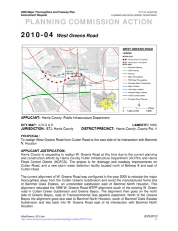
2009 Major Thoroughfare and Freeway PlanAmendment RequestCITY OF HOUSTONPLANNING AND DEVELOPMENT DEPARTMENTPLANNING COMMISSION ACTION2010-04West Greens RoadAPPLICANT: Harris County, Public Infrastructure DepartmentKEY MAP: 370 Q & RJURISDICTION: ETJ, Harris CountyLAMBERT: 5065DISTRICT/PRECINCT: Harris County, County Pct. 4PROPOSAL:To realign West Greens Road from Cutten Road to the east side of its intersection with BammelN. HoustonAPPLICANT JUSTIFICATION:Harris County is requesting to realign W. Greens Road at this time due to the current planningand construction efforts by Harris County Public Infrastructure Department (HCPID) and HarrisFlood Control District (HCFCD). The project is for drainage and roadway improvements onCutten Road, and a new storm water detention facility located north of Beltway 8 and east ofCutten Road.The current alignment of W. Greens Road was configured in the year 2000 to relocate the majorthoroughfare away from the Cutten Greens Subdivision and avoid the manufactured home lotsof Bammel Oaks Estates, an unrecorded subdivision east of Bammel North Houston. Thisalignment relocated the 1999 W. Greens Road MTFP alignment south of the existing W. Greenroad in Cutten Green Subdivision and Greens Bayou. The alignment then goes on the northside of Greens Bayou, east of Transcontinental Gas pipeline easement. North of the GreensBayou the alignment goes due east to Bammel North Houston, south of Bammel Oaks EstatesSubdivision and ties back into W. Greens Road east of its intersection with Bammel NorthHouston.WestGreens egs/mobility/MTFP.html8/25/20101
2009 Major Thoroughfare and Freeway PlanAmendment RequestCITY OF HOUSTONPLANNING AND DEVELOPMENT DEPARTMENTPLANNING COMMISSION ACTIONThe current W. Greens Road alignment is adjacent to the Greens Bayou and includes anawkward crossing of Greens Bayou and drainage channel P 149-00-00 into the HCFCDdetention site. The W. Greens Road would require a new bridge crossing the over GreensBayou and the drainage channel P149-00-00 in order to tie into the existing section of CuttenRoad. HCPID, along with HCFCD proposes realigning this section of W. Greens Road to beextended from Cuttens Road approximately 0.35 miles south of Greens Bayou to Hollister Rd.through the HCFCD property and tie directly into existing Cutten Road. This new alignment willutilize the existing Cutten Road bridge that currently crosses Greens Bayou, negating the needfor a new bridge.The Harris County Precinct 4 Capital Improvement Plan (CIP) calls for designing the four-laneboulevard for a proposed realignment of W. Green Road. The infrastructure improvement wouldinclude a storm sewer system, drainage outfall, storm water detention, and bridges over GreensBayou and BNRR track. This project is being designed and will be constructed in two segments;A) from east of SH 249 to Cutten Road, and B) from Cutten Road to Hollister Road. Segment Ais in the engineering design phase and is scheduled for TxDOT letting in the 4th quarter of2010. Segment B is in the engineering design phase and the goal is to request Commissioners'Court authorization to bid in the 4th quarter of 2010. Hollister Road from the Beltway 8 to FM1960 is also scheduled for improvements to a four-lane boulevard section. The proposedimprovements will improve the mobility in the general area.STAFF RECOMMENDATION:Realign West Greens Road from Cutten Road to the east side of its intersection with Bammel N.Houston.JUSTIFICATION:The MTFP alignment of proposed West Greens Road crossing the Greens Bayou twicebetween Cutten and Bammel N. Houston creates an impractical configuration of the roadway.The proposed configuration of West Greens Road allows for the direct extension of Cutten Roadinto W. Greens Road away from Greens Bayou. It also allows for an intersection of W. Greensand Hollister away from Greens Bayou. The right-of-way of W. Greens Road between Cuttenand Bammel Oaks (unrecorded subdivision) would be dedicated through the Harris CountyFlood Control Authority parcels.PLANNING COMMISSION ACTION:Realign West Greens Road from Cutten Road to the east side of its intersection with Bammel N.Houston.FACTORS ASSESSED:1. HistoryGreens Road alignment first appeared on the City of Houston’s Major Thoroughfare andFreeway Plan (MTFP) in 1957 between West Montgomery Road and West Lake HoustonParkway. Bammel, Hollister and Fairbanks North Houston are other north-souththoroughfares identified on this 1957 MTFP. In the year 1966 the extension of Hollister,north of Beltway 8, is realigned along a portion of Cutten Road and Fairbanks NorthHouston. Greens Road is realigned to be tied into an existing east-west unnamedthoroughfare (Cypress N. Houston). In 1969 Fairbanks North Houston is realigned along anWestGreens egs/mobility/MTFP.html8/25/20102
2009 Major Thoroughfare and Freeway PlanAmendment RequestCITY OF HOUSTONPLANNING AND DEVELOPMENT DEPARTMENTPLANNING COMMISSION ACTIONunnamed east-west thoroughfare (Richey Road) south of FM 1960. Major thoroughfareCutten Road is terminated at Greens Road and is realigned from Greens Bayou to theBeltway 8 and Hollister.The 1972 MTFP extends Hollister north of Beltway 8 into Cutten Road. Fairbanks NorthHouston, north of Beltway 8 is realigned and the segment between SH 249 and GreensRoad is deleted. In 1976 Hollister, north of Beltway 8 was realigned along Richey Road.Remainder of Richey road is short thoroughfare segment between Greens Road andChampion Forest.In 1980 the thoroughfare segments in the area realigned and reconfigured. Portion ofGreens Road between Hollister and Stuebner Airline south of Greens Bayou. Richey Roadis realigned and terminates at Cutten Road. Hollister is also realigned to terminate at RicheyRoad. Fairbanks North Houston terminates at Beltway 8. Champion Forest is terminated atBammel North Houston. Lastly Bammel North Houston is extended to FM 1960. The 1986MTFP extends Richey Road from Cutten to Greens Road as a major thoroughfare.The 1997 MTFP map labels the Greens Road alignment west of IH 45 as W. Greens Road.In 1998 the Cutten Green Home Owners Association requested the deletion of W. GreensRoad between Cutten Road and Bammel North Houston Road. The Planning Commissiondenied the deletion of W. Greens Road. Most recently, in the year 2000, the MTFPamended the W. Greens, Cutten and W. Richey Road alignment. W. Greens Road wasrealigned at Bammel N. Houston and extended into Cutten Road. West of Cutten Road, W.Greens was realigned to align with W. Richey Road. This alignment also requires W. Greento cross Greens Bayou twice between Cutten and Bammel North Houston.1957 MTFPWestGreens egs/mobility/MTFP.html1966 MTFP8/25/20103
2009 Major Thoroughfare and Freeway PlanAmendment RequestCITY OF HOUSTONPLANNING AND DEVELOPMENT DEPARTMENTPLANNING COMMISSION ACTION1985 MTFP1997 MTFP2000 MTFP2009 MTFPWestGreens egs/mobility/MTFP.html8/25/20104
2009 Major Thoroughfare and Freeway PlanAmendment RequestCITY OF HOUSTONPLANNING AND DEVELOPMENT DEPARTMENTPLANNING COMMISSION ACTION2. Population & Employment ProjectionsTexas is one of the fastest growing states in the nation, and Harris County is the fastestgrowing county in the state1. Today, more than 2.2 million people live in the City of Houstonand another 700,000 live in the City’s ETJ. Houston and its ETJ’s rich employment sectorare home to more than 1.7 million jobs, making it the state’s most populous and robusteconomic center.One of the greatest challenges to Houston’s mobility is that by 2035, more than 870,000new residents are projected to live outside the City limits in the ETJ while the major thrust ofemployment growth is within the City limits. The increase in the percentage of populationfurther away from employment centers will result in more vehicle miles traveled (VMT),greater vehicle hours traveled (VHT), and thus longer travel delays in the greater HoustonRegion.While the ETJ is growing, the City will also be taking in an additional 550,000 new residents.The most notable population growth will occur inside Loop 610. It will reflect efforts tocreate a dense urban core through mixed-use development strategies.The Houston-Galveston Area Council (H-GAC) projects that over 25 years (2010 – 2035)the population within the study area* will increase by 17.5%, or from 12,569 to 14,771persons. Persons per acre are projected to increase from approximately 3.64 toapproximately 4.28. During the same period, H-GAC estimates that total jobs in the subjectarea will increase by 1,980 from 8,516 to 10,496 (23.3%). Jobs per acre are projected toincrease from approximately 2.47 to 3.04.Expressed in percentages, the subject area’s population growth is expected to be less thanthe City of Houston’s (17.5% versus 22.6%), and the area’s job growth is expected to beless than the City’s (23.3% versus 34.0%).West GreensRd. StudyArea*Year201020152020202520302035Change (2010 - 2035)Change in City ofHouston (2010 - 2035)Change in Houston’sETJ (2010 - .280.64% 612.742.872.913.040.57% 51.291.401.521.561.560.41% 69.2%86.1%Source: H-GAC’s 2035 Regional Growth Forecast* Data represents population, jobs, and households in 3 Traffic Analysis Zones (TAZ) encompassing approximately 3,453acres around the proposed amendment. Population projections do not include projections for group housing.1.Eschbach, Karl. “Population Change in Texas” Texas State Data Center. 2008http://txsdc.utsa.edu. Accessed May, 2009.WestGreens egs/mobility/MTFP.html8/25/20105
2009 Major Thoroughfare and Freeway PlanAmendment RequestCITY OF HOUSTONPLANNING AND DEVELOPMENT DEPARTMENTPLANNING COMMISSION ACTION3. Platting ActivityProperty within the general area where the West Greens Road MTFP is being requested isa mixture of existing single family residential and emerging commercial development. Theexisting residential developments are mainly located north of the old alignment for WestGreens Road, although south of the requested MTFP alignment, along Bammel N HoustonRoad, there is also an established single family residential development. From 2006 to2009, the majority of the platting activity in the area had been for emerging commercialdevelopment either fronting or in close proximity to other major thoroughfares in the areanamely, Cutten Road, Hollister Road, and Bammel- N Houston Road.Subdivision PlatNameCutten Road CommercialProperty SubdivisionBeltway Bammel5Development SubdivisionBammel and BeltwayCommercial Tract Sec 1Cyclone Steel SubdivisionNorthwest Harris CountyMUD No 24 Waste WaterTreatment PlantHighlife Business ParkSubdivisionIGS Industrail SubdivisionHollister Business ParkSec1Yousse Cutten RoadSubdivisionFour Seasons BusinessPark SubdivisionHollister Business Park Sec2Cutten Green BusinessPark SubdivisionHouston DistributingCompany SubdivisionCutten Road Business andIndustrial Park SubdivisionGreens Road FedEx SiteSubdivisionBammel Oaks EstatesPlaza Subdivision (DEF)Action DateKey MapLand UseProperty 9371NCommercial912-Nov-09371NCommercial1No. ofLots4. Harris County, Capital Improvement PlanBelow is a detailed table showing either completed or proposed projects from the HarrisCounty Precinct 4 Capital Improvement Plan for Hollister Road and W. Greens RoadWestGreens egs/mobility/MTFP.html8/25/20106
2009 Major Thoroughfare and Freeway PlanAmendment RequestCITY OF HOUSTONPLANNING AND DEVELOPMENT DEPARTMENTPLANNING COMMISSION ACTIONHarris County Precinct 4 CIPProject NameLimit FromLimit ToHollister Rd - 1Beltway 8W Greens RdHollister Rd - 2W Greens RdBourgeois RdHollister Rd - 3Bourgeois RdFM 1960West Greens Rd ABSH 249Hollister DrNotesInstallation of a 4-lane concrete boulevard section withstorm sewer system and offsite storm water detention.Project was awarded to Beyer Construction and iscurrently in the construction phase. Constructionactivity commenced September 21, 2009 and isscheduled for construction completion by September29, 2010. (Last Updated On 5/14/2010)Installation of a 4-lane concrete boulevard section withstorm sewer system, traffic signalization on Hollister atBourgeois and offsite storm water detention. Projectwas awarded to Beyer Construction and is currently ed September 21, 2009 and is scheduled forconstruction completion by September 29, 2010. (LastUpdated On 5/14/2010)Proposed extension of a 4-lane concrete boulevardsection with storm sewer system and offsite stormwater detention between Bourgeois Road and DuncanRoad; planned improvements include upgradingDuncan Road from a 2-lane asphalt pavement to a 4lane concrete boulevard section with storm sewersystem. Project is currently in the engineering designphase and our goal is to request Commissioners' Courtauthorization to bid in the fourth quarter of 2010. (LastUpdated On 4/23/2010)Proposed 4-lane concrete boulevard, including stormsewer system, drainage outfall, storm water detention,and bridge over Greens Bayou and BNRR track.Project is being designed and will be constructed in twosegments; A) from east of SH 249 to Cutten Road andB) from Cutten Road to Hollister Road. Segment A is inthe engineering design phase and is scheduled forTxDOT letting in the 4th quarter of 2010. Segment B isin the engineering design phase and our goal is torequest Commissioners' Court authorization to bid inthe 4th quarter of 2010. (Last Updated On 5/14/2010)5. Right-Of-Way StatusThe rights-of-way for all the thoroughfares in the vicinity are labeled either with sufficientwidth or as to be acquired status. Some thoroughfares in the subject area lack continuity.On the 2009 MTFP map West Greens Rd. is shown as ‘to be mmel N. HoustonBammel N. HoustonBammel N. HoustonWeedsWeedsWeedsHollisterHollisterFromFM 1960CuttenHollisterBammel N.HoustonW. RicheyChampion ForestW.GreensSH 249CuttenHollisterWeedsW. l N. ent widthTo be acquiredTo be acquiredAntoine Dr.ThoroughfareTo be acquiredChampion ForestW. GreensBeltway 8CuttenHollisterChampion ForestW. GreensBeltway ficient widthSufficient widthSufficient widthSufficient widthTo be acquiredTo be acquiredSufficient widthSufficient widthWestGreens egs/mobility/MTFP.html8/25/20107
2009 Major Thoroughfare and Freeway PlanAmendment RequestCITY OF HOUSTONPLANNING AND DEVELOPMENT DEPARTMENTPLANNING COMMISSION ACTION6. Major Thoroughfare SpacingFM 1960 and W. Greens Rd. are still the most prominent east to west thoroughfares. Thereare numerous segments that are still in the proposed stage which makes the thoroughfarespacing sporadic. This can be seen at locations at West Greens, between Hollister andBammel N. Houston, which is a proposed segment and extends to the west of Hollister andWest Richey which turns into Weeds Rd at Cutten between FM 1960 and West Greens. Thespacing for the thoroughfares mentioned in the chart below range from under a mile toalmost a mile and a half in the north to south direction. East to west thoroughfaresmeasured approximately over a mile and a half at the widest point of spacing.StreetCuttenBammel N.HoustonBammel N.HoustonBammel isterFM 1960FM 1960W. GreensW. GreensW. GreensFromToStreet TypeDirectionSpacingFM 1960W. GreensThoroughfarenorth-south0.98 miW. RicheyChampion ForestThoroughfarenorth-south0.32 miChampion ForestW. GreensThoroughfarenorth-south0.73 miW. GreensBeltway. 8Thoroughfarenorth- south0.64 miFM 1960W. RicheyThoroughfarenorth- south1.50 miW. RicheyBammel N. HoustonThoroughfarenorth- south0.34 miWeedsW. GreensCuttenChampion ForestWeedsHollisterBammel N. HoustonW. GreensBeltway 8Champion ForestVeterans MemorialHollisterBammel N. rth- southnorth- 1.36 mi0.48 mi1.45 mi1.06 mi1.46 mi0.46 mi0.89 mi7. MobilityBammel N. Houston and Hollister are the primary north to south thoroughfares other thanSH 249 and Veterans Memorial Dr. in the region. Beltway 8 and F.M. 1960 are the maineast to west thoroughfares.As shown in table below, the Average Daily Traffic (ADT) increase on West Greens Rd.between Bammel N. Houston Rd. and Antoine Dr. goes from 8,951 in the ‘without’ W.Greens Rd. scenario to 13,934 in the ‘with’ W. Greens Rd. scenario in 2015. Due to this55.7% ADT increase, the Level-of-Service (LOS) rating along this segment deteriorates from“B” to “E” in 2015. LOS rating on FM1960 between Cutten to Champion Forest is “F” in2015 and is projected to stay at this level in 2035.According to the Model and table --- the 2035 scenarios for W. Greens Rd. indicate somesignificant results for ADT on W. Greens Rd. They include:72% increase in ADT for W. Greens Rd. from Antoine Dr to Veterans MemorialDr. The ADT in this segment increases from 11,706 in the “without” W. GreensRd. scenario to 20,161 in the “with” W. Greens Rd. scenario.The ADT for numerous segments in the two different scenarios continue to showdecreases in the ADT should the new segment be built or not. The reductionWestGreens egs/mobility/MTFP.html8/25/20108
2009 Major Thoroughfare and Freeway PlanAmendment RequestCITY OF HOUSTONPLANNING AND DEVELOPMENT DEPARTMENTPLANNING COMMISSION ACTIONeither improved the LOS or kept the LOS the same such as FM 1960 fromChampion Forest Dr. to Veterans Memorial Dr. with a LOS of E.Based on the Travel Demand Model, the ADT for W. Richey Rd. decreases from18,279 in the “without” W. Greens Rd. scenario to 11,564 in the “with” W. GreensRd. scenario. This represents a 37% reduction in ADT.STREETFM 1960FM 1960FM 1960FM 1960W. GreensW. GreensW. GreensW. GreensW. GreensW. RicheyW. RicheyW. RicheyW. RicheySH 249SH GE DAILY TRAFFIC COMPARISON WITH & WITHOUT WEST GREENSWithoutWithWithoutWith%% ChangeW.W.W.W.Changewith W.GreensGreensGreensGreenswith W.GreensGreensSEGMENT2015201520352035SH 249 to Cutten70,37969,500-1.2%125,746 125,065-1%Cutten to Hollister54,51057,2865.1%106,146 103,782-2%Hollister to Champion65,63763,531-3.2%116,481 114,789-1%ForestChampion Forest to57,31456,639-1.2%108,399 107,160-1%Veterans MemorialSH 249 to CuttenCutten to HollisterHollister to BammelN. HoustonBammel N. Houstonto AntoineAntoine to VeteransMemorialCutten to HollisterHollister to ChampionForestChampion Forest toBammel N. HoustonBammel N. Houstonto Veterans MemorialFM 1960 to W.GreensW. Greens to BW 8FM 1960 to W.RicheyFM 1960 to W.RicheyW. Richey to W.GreensW. Richey to BW 8W. Greens to BW 42,158N/AN/A44,981N/AN/AChampionForestFM 1960 to estW. Richey toBammel N. stonVeterans Memorial toW. W. Richey toChampion Forest16,05214,499-9.7%21,61520,853-4%WestGreens egs/mobility/MTFP.html8/25/20109
2009 Major Thoroughfare and Freeway PlanAmendment RequestCITY OF HOUSTONPLANNING AND DEVELOPMENT DEPARTMENTPLANNING COMMISSION ACTIONSTREETAVERAGE DAILY TRAFFIC COMPARISON WITH & WITHOUT WEST GREENSWithoutWithWithoutWith%% ChangeW.W.W.W.Changewith W.GreensGreensGreensGreenswith Champion Forest toW. onW. Greens to BW ,04724,3506%AntoineVeterans Memorial toW.GreensW.Greens to BW 824,29723,494-3.3%33,40833,6811%VeteransMemorialFM 1960 toBammel N. morialBammel N. Houstonto morialW. Richey to orialAntoine MemorialW. Greens to BW 152-1.2%172,286167,564-3%AntoineBeltway 8Beltway 8Beltway 8Beltway 8STREETFM 1960FM 1960FM 1960FM 1960W. GreensW. GreensW. GreensW. GreensW. GreensW. RicheyVeterans Memorial toAntoineAntoine to Bammel N.HoustonBammel N. Houstonto HollisterHollister to SH 249LEVEL OF SERVICE COMPARISON WITH & WITHOUT WEST GREENS2015 Without2015 With W.2035 WithoutW. GreensGreensW. GreensSEGMENTV/CLOSV/CLOSV/CLOSSH 249 to Cutten1.32F1.3F1.17FCutten to Hollister0.86E0.91E0.99EHollister to Champion1.04F1.01F1.07FForestChampion Forest to0.91E0.9E0.99EVeterans Memorial2035 With W.GreensV/CLOS1.16F0.95E1.07F0.99ESH 249 to Cutten0.57B0.59B1.07F1.07FCutten to HollisterN/AN/A0.81DN/AN/A1.16FHollister toBammel N. HoustonBammel N. Houstonto AntoineAntoine toVeterans 0.36A0.61B0.41A0.71CCutten to Hollister0.25A0.13A0.64B0.41AWestGreens egs/mobility/MTFP.html8/25/201010
2009 Major Thoroughfare and Freeway PlanAmendment RequestCITY OF HOUSTONPLANNING AND DEVELOPMENT DEPARTMENTPLANNING COMMISSION ACTIONSTREETW. RicheyW. RicheyW. RicheySH 249SH ialVeteransMemorialBeltway 8Beltway 8Beltway 8Beltway 8LEVEL OF SERVICE COMPARISON WITH & WITHOUT WEST GREENS2015 Without2015 With W.2035 WithoutW. GreensGreensW. GreensSEGMENTHollister to1.04F0.97E1.25FChampion ForestChampion Forest to0.79D0.74C1.09FBammel N. HoustonBammel N. Houston0.18A0.08A0.83Dto Veterans MemorialFM 1960 to0.54B0.55B0.77DW.GreensW. Greens to BW 80.51B0.49B0.73CFM 1960 to W.0.31A0.44A0.44ARicheyFM 1960 to W.0.33A0.34A0.61BRicheyW. Richey toN/AN/A1.02FN/AN/AW.GreensW. Richey to BW 81.29FN/AN/A1.48FW. Greens to BW 8N/AN/A1.39FN/AN/AFM 1960 to W.0.71C0.72C0.66CRicheyW. Richey to0.67C0.59B0.63CBammel N. HoustonVeterans Memorial to0.82D0.96E0.96EW. RicheyW. Richey to0.61B0.56B0.83DChampion ForestChampion Forest to1.38F1.23F1.41FW. GreensW. Greens to BW 82035 With 6F1.19F1.19F1.24F1.2F1.18F1.18FW. Richey to Antoine1.52F1.39F1.49F1.38FAntoine to W.Greens0.97E0.97E1.01F1.05FW. Greens to BW erans Memorial toW.GreensW.Greens to BW 8FM 1960 to BammelN. HoustonBammel N. Houstonto W. RicheyVeterans Memorial toAntoineAntoine toBammel N. HoustonBammel N. Houstonto HollisterHollister to SH 249WestGreens egs/mobility/MTFP.html8/25/201011
2009 Major Thoroughfare and Freeway PlanAmendment RequestCITY OF HOUSTONPLANNING AND DEVELOPMENT DEPARTMENTPLANNING COMMISSION ACTIONWestGreens egs/mobility/MTFP.html8/25/201012
2009 Major Thoroughfare and Freeway PlanAmendment RequestCITY OF HOUSTONPLANNING AND DEVELOPMENT DEPARTMENTPLANNING COMMISSION ACTIONWestGreens egs/mobility/MTFP.html8/25/201013
Greens Road alignment first appeared on the City of Houston's Major Thoroughfare and Freeway Plan (MTFP) in 1957 between West Montgomery Road and West Lake Houston Parkway. Bammel, Hollister and Fairbanks North Houston are other north-south thoroughfares identified on this 1957 MTFP. In the year 1966 the extension of Hollister,