Transcription
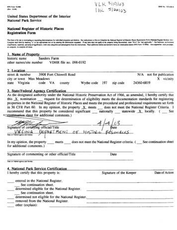
NPS F m 1&5i#l( R n 10-90)United States Department of the InteriorNational Park ServiceNational Register of Historic PlacesRegistration Form-r a t s fmn u fo lo mmim.tinra r e q u r r i n g m e m l m h r for indindlll mn md d6siro. Slc inlavcaan in nova m p l m hrNodwle mnofHuwrc Pblolo f i t l m m f a Form INRep- Bvllmn 16,)'NIA' f a ' z d W i o b k . ' Fo fuac6m. mh mnlbox a 4 r a r i n g the btmma6-m r e q d If my ilrm mrr ar appb ro the popem l!&g d o r u m ,Cornplea n r h ilnn by mn*inl 'r' in fbcrladfmtion. rmaniab. acdaruaf d p i h c e . cnbxoaly cmrgain druboWn fmm the in&-,.Pbrr.dmdmdW a c d n m u i v ilrmxm c & l hsbze3 CNTS Fom 1&%1U r lCFwftm, w a d pr-,u compubx, to m p l m dl itoor.1. Name of Propertyhistoric nameSanders Farmother nameslsite numberVDHR file no. 098-01922. Location3908 Fort Chiswell Roadstreet & numbercity or town Max Meadowsstate Virginiacode VA countyWythe code197zip codeNIA not for publicationX vicinity24360-68 193. StatelFederal Aeencp Certification-As the designated authoritv under the National Historic Preservation Act of 1966. as amended. I herebv certify thatthis A nomination - ;equest for determination of eligibility meets the documentation standards fir regis;eringproperties in the National Register of Historic Places and meets the procedural and professional requirements set forthin 36 CFR Part 60. In myopinion, the propertymeets -'does not meet-the National Register Criteria. Irecommend that this property be considered significant - nationally - statewide X locally. ( - See i 6 a t u r k o fcert@i?ng officialITitleIn my opinion, the propertyfor additional comments.)meetsdoes not meet the National Register criteria. ( -See continuation sheetSignature of commenting or other official1Title4. National Park Service CertificationI hereby certify that this property is:entered in the National Register.- See continuation sheet.determined eligible for the National Register.- See continuation sheet.determined not eligible for the National Register.removed from the National Register.other (explain):DateSignature of the KeeperDate of Action
Sanders FarmWythe Co. Va.Name ofcaw ml!sate5 . ClassificationOwnership of PropertyCategory of PropertyNumber of Resources within Property(chccku-bornu,ppi71( m emly me boil(DOar iacluk p.riauly l i e d -nX private-public-local-public-Statepublic-FederalX building(s)-district-site- structure-objectContributing13Name of related multiple property listing(Ems 'NIA. ifism4 put ar I m u p popmy ctidog.)Historic Functions(En,"in the c w . cts177Total3Number of contributing resources previously listedin the National RegisterCurrent FunctionsM g o M fmm in*)(Emsfmm REEXTRACTIONTRANSPORTATIONTRANSPORTATIONsingle dwellingsecondary structuredepartment storestorageagricultural fieldanimal facilityextractive RICULTUREAGRICULTUREAGRICULTUREVACANTINOT IN USEsingle dwellingsecondary structurestorageagricultural fieldanimal facilityArchitectural ClassificationMaterials(En," o t q a i m horn ialrmcflrn)[En- *sin fmm h,t.Xtirn,)Queen creteNarrative Description(-bea. h i w c md m, d mol thc pmpcrm oo ooc a-coodnvtlm h.)
Wvthe Co. Va.Sanders FarmCmm md SmeHame of RoprmB. Statement of SienificanceApplicable National Register CriteriaCriteria Considerations(MarL 'r' i n me a mrr b o r n f a tbr mail-8mc pmpmv f a N s t i d R m l i d n . )( M A 'X'rn all tbe box- tbn apply)h ; .RoprmbrmchrcddaYkd-snpaiflnm in cur prt.Roprm embadin aY ddrdrr charrtmda ofa*pe,pcricd.ornnhodof moq m n m br *at of. rn-,a poaacr highdun. u r c p n a r I t i r o l f i mdtMowishable mAy r h mmpoasntc l u kindmau.1 di%i"&.Ropcrr/ MykIW. a is l k l y myield.i"fonvdan i n p a a n t in pbistm, rn hinay.8x c--DPeriod of SignificanceAreas of Significance( E n m atmn horn bmc mr)Ca. 1880-1953ARCHITECTUREENGINEERINGSignificant DatesCa. 1880Cultural AffiliationSignificant Person(Camp&if CWmh 8 ir omtd lbwelArchitectlBuilderunknownNarrative Statement of Significance(Elpluo mc m a n s of the pmpcm an mc or mrr dnlulim I*cll.)9. Major Bibliopraphical ReferencesBibliographycotc mc M ,uaclo. lad ahr wcca uxd la prepiar a i r f m m me o-d n d mPrevious documentation on file (NPS):-preliminary determination of individual listing(36 CFR 67) has been requested-previously listed in the National Register-previously determined eligible by the NationalRegister-designated a National Historic Landmark- recorded by Historic American Buildings Survey#- recordedby Historic American Engineering RecordPrimary location of additional data:X State Historic Preservation Office- Other State agency-Federal agency-Local government- University- OtherName of repository:
Wythe Co. Va.Sanders FarmCarw ad sewNunrdmp7y10. Geo raohicalDataapproximately 170acresAcreage of PropertyUTM References(PI,"* nddtionr) mmi-on. matinwtlrr b)Zone Easting Northing1 17 51128040816402 17 511900 4081900X scc c m w t l r br .-Zone Eating Northing3 17 511950 40814204 17 512300 4081450Verbal Boundary Description( W kEw bxodsnn of*pmpeny on. continvdm b.)-Boundary Justification(ErpUn why Ulc boundsnnx l m d an s ccodaudea b.)11. Form Prepared Bynameltitleorganizationstreet & numbercity or town1. Daniel Pezzon:ILandmark Preservation Associates date5H o u mtelephoneLexingtonstate VAzip codeJanuarv 17. 20031540) 464-53 1.524&%Additional DocumentationContinuation SheetsMapsA USGS map (7.5 or 15 minute series) indicating the property's location.A Sketch map for historic districts and properties having large acreage or numerous resources.PhotographsRepresentative black and white photographs of the property.Additional items( k k wim me SHPO a FPo f u my nddtiond iolrn,)Property Ownernamestreet & numbercity or townBobby Joe Jennings (owner and contact)144 Foxfue Roadtelephone@J,Q 699-6819Max Meadowsstate VAzip code24.36Q- mctlm c f s f . cn i, i o tf d o . Y kiqr o 1 1 - df u m l i w a u m m . donr) e p r r r o i n a li cu r s m m m i - e f u w p a m - m i im e w n a knefn m uc&remh &C N i Rsrrndo. rAR. u a m c a w (16 U S c . 470 a q.).cximng limnp. n p o n rov *,Ii,P.-eti 33Wh* M i n x , m b Mo .nd lo amendmd n d b g b.ad c n n p w g a d -owns UlrEdmzted Burhn Statement: Rlblic drip bvrdcn f u *s form is crrimmd m18.1 hmn s rrrpoar mcWn8 m. time f a rcrimns inrm*.f m Lhmt rommrna rcpanbnp * bo*emrm a m yoilhis form m Ew mid. A b i n i d w W c s Diviim, N d d Rnm e . P.O. Bm 37121. W & p ,DC Xall-7127; md me M r c dMvusc-1and nudm. Rpma* R d u h r Rolm (102UW111). W & p .DC m m 3 .
United States Department of the InteriorNational Park ServiceNational Register of Historic PlacesContinuation SheetSection number7 Page 1Sanders FarmWythe Co., Va.NARRATIVE DESCRIPTIONSummaryThe Sanders Farm is located at 3908 Fort Chiswell Road (US Highway 52) near Fosters Fallsin southeast Wythe County, Virginia. The nominated area of approximately 170 acres lies on thenorth side of the New River, a tributary of the Mississippi River system, and comprisesbottomland and open and wooded hillsides. The elevation on the river lies at just over 1,900 feetabove sea level. The highest elevations, at the north end of the nominated area, approach 2,300feet. Bounding the nominated area on the west side is Interstate 77 and its twin New Riverbridges, which stand approximately 110 feet above the southwest end of the nominated area.Crossing the southwest comer of the nominated area are the two-lane Route 52 and the north endof the Route 52 Jackson Ferry Bridge (the bridge is excluded from the nominated area). Visiblefrom the property across the New River are the Shot Tower, a stone tower erected in the earlynineteenth century for the making of lead shot and now interpreted as the Shot Tower StateHistorical Park, and the 1880s Cripple Creek line of the Norfolk & Western Railroad, atransportation improvement that supported the Hematite Iron Company Mine operation on theSanders Farm (see Section 8) and is now being developed as a rails-to-trails conversion.Most of the farm's resources are clustered at the southwest end of the nominated area on thenorth side of Route 52. hincipal among these resources is the Sanders farmhouse, known as theBrick House, a two-story Victorian house of brick construction built about 1880 (probably in1879-80). The house is distinguished by its ornamental gables and porches, and, on the interior,by plaster ceiling medallions and other decorative features. The outbuildings are arrayed in aloosely organized double row extending from directly behind the house eastward. Functionally,the outbuildings at the west end of the group are more domestic in character; those near thecenter have a more public orientation; and those at the east end are farm related. The easternmostoutbuildings include a cold frame with a stepped front parapet, a vaulted stone springhouse, anda one-story brick outbuilding that appears to have served as servants quarters. Next are a cinderblock store with an upstairs apartment and an accompanying privy, a frame vehicle repair shop,and a stone reservoir. The farm buildings include a large frame corncrib, a smaller log corncrib,and a frame gambrel-roofed barn. Northeast of this main group of resources is a second groupconsisting of a one-story tenant house, apparently of boxed construction, associated ruinousoutbuildings, and stone bridge abutments. At the north end of the nominated area is the site ofthe Hematite Iron Company Mine, a complex of rock formations and tram line beds.
United States Department of the InteriorNational Park ServiceNational Register of Historic PlacesContinuation SheetSection number7 Page 2Sanders FarmWythe Co., Va.Description (continued)InventoryI . Brick House. Ca. 1880; 1930s. Contributing building.2. Cold frame. Ca. 1900. Contributing building.3. Springhouse. Ca. 1880. Contributing building.4. Servants quarters. Ca. 1880. Contributing building.5. Wood shed. Mid-20th c. Contributing building.6. Reservoir. Ca. 1880. Contributing structure.7. Shop. Ca. 1920. Contributing building.8. Store. Early 1950s. Contributing building.9. Store privy. Early 1950s. Contributing building.10. Bam foundation. Late 19th c. Contributing site.11. Granary. Early 20th c. Contributing building.12. Barn. Early 20th c. Contributing building.13. Corncrib. Late 19th c. Contributing building.14. Scales house. Early 20th c. Contributing building.15. Tenant house. Ca. 1920. Contributing building.16. Bridge abutments. Late 19th c. Contributing site.17. Hematite Iron Company Mine. Late 1880s. Contributing site.18. Play house. 1960s. Noncontributing building.19. Shed ruin. Early 20th c. Noncontributing site.20. Machinery shed ruin. Mid-20th c. Noncontributing site.21. Machinery shed. 1990s. Noncontributing building.22. Tenant house shed ruin. Mid-20th c. Noncontributing site.23. Tenant house privy ruin. Mid-20th c. Noncontributing site.24. Transmission line. Early 1970s. Noncontributing structure.House ExteriorThe Brick House has a T-shaped plan with a two-story forward and backward-projecting wingon the left-hand (west) side. The house is constructed of American-bond brickwork with Flemishvariant on the south-facing front elevation. The mortar joints are pencilled, and next to the frontentry is a brick with a little girl's footprint said to be that of an Elizabeth Sanders. Thefoundation is ashlar limestone except under the front one-story bay window, which stands on afoundation of either smooth tan limestone or poured concrete construction. The gable roof iscovered with slate shingles and is provided with lightning arrestors. Two front and two side
United States Department of the InteriorNational Park ServiceNational Register of Historic PlacesContinuation SheetSection number7 Page 3Sanders FarmWythe Co., Va.Description (continued)gables have round louvered vents and ornamental cross-bracing with chamfered stanchions andcross members, turned bosses, tendril-like piercings, and a faceted pendant (the one rear gableis plain). Rising above the roof are two brick chimneys with peaked, corbeled, and recessedpanels on their faces and caps with decorative corbeling of alternating projecting and recessedbricks. The roof formerly supported a widow's walk with a wood balustrade with ball finials onthe corner posts. The widow's walk and a balustrade with turned balusters that ringed the top ofthe front bay window were removed in the 1930s to discourage the young Jennings family boyswho then lived in the house from climbing out onto the main and bay window roofs.The one-story front porch, which is believed to have been reduced in extent in the 1930s or1940s, is supported by paired chamfered posts yoked at the top by sawn brackets with a foliatedpendant in the interstices between posts. Other porch features include a bracketed cornice withshallow dentil-like ornaments in the frieze, a beaded matchboard ceiling, and an underpinningof lattice and paired brick foundation piers (formerly there were decorative pierced panels in thenarrow spaces between the piers). A one-story porch was added to the west elevation in thetwentieth century. A third porch, enclosed, extends across the back of the house. A porchoriginally stood in this location; the present one is either a reconstruction or enclosure of theoriginal and has weatherboard siding, six-over-six windows, and beaded matchboard interiorsheathing.Other exterior features include a front entry with a two-light transom and a two-leaf front doorwith two panels in each leaf; two-over-two windows with splayed jack arches and moldedwooden surrounds; tall two-over-four dining room windows; and a two-story rear bathroomaddition of brick made in the 1930s. In front of the house extends an original or early brickwalkway with a dogtooth edging. Behind the house is a modern brick patio with a circular paverdesign incorporating the footprints of grandchildren of the present owner, Bobby Joe Jennings.House InteriorThe house has a modified center-passage plan. Typical finishes include plaster on brick wallswith modern wallpaper, plaster-and-lath ceilings, wood floors, wood mantels, molded and beadeddoor and window mm, molded wood cornices, four-panel doors, and interior doorways withtransoms and paneled embrasures. Each of the four principal first-floor rooms--the centerpassage, the front and rear parlors to the left of the passage, and the dining room to the right ofthe passage--have plaster ceiling medallions of varied form and ornamentation (describedindividually for each room). The center passage, entered through the two-leaf front door, has
NPS F a n I O W B(8.86)United States Department of the InteriorNational Park ServiceNational Register of Historic PlacesContinuation SheetSection number7 Page 4Sanders FarmWythe Co., Va.Description (continued)alternating narrow walnut and heart pine floor boards that create a two-tone striped effect, andit contains a one-run stair with turned walnut balusters and newel.The front parlor has a basket-handle archway with a bullnose edge molding that opens into thefront bay window. The medallion has a complex, almost rococo design of arabesques, ivy leaves,flowers, and stippling. The simple Victorian-inspired mantel was installed in the 1930s to replacethe original, moderately more ornate Victorian mantel (now installed in an adjacent 1950shouse). Other front parlor features include a rough plaster dado below a beveled chairrail, a woolcarpet that has been in the room since the 1930s, and modem wallpaper reproduced from apattern in Tudor Place, Georgetown, District of Columbia.The rear parlor has a fireplace flanked by closets and provided with a mantel with recessed andprojecting molded panels. The medallion has a compass rose-like form, incised arabesques, andstippling. A French door opens onto the side porch. The dining room has a mantel with raisedpanels and a peaked backboard, and a circular medallion with lobes around its edge (the fourprincipal lobes with avocado motifs) and curved panels with incised arabesques. A small roomat the east gable end, once used as a bed room, was converted into a kitchen after 1930. The1930s bathroom has original fmtures, a tile floor, and a tall light green tile wainscot with adecorative tile border with a pattern of water lilies in pink, red, and dark green.The second floor is similar in plan and finish to the first floor. The mantels are hybrid GreekRevival-Gothic Revival in inspiration, with peaked frieze profiles, molded pilaster caps, and bedmoldings. The mantel in the southwest room is more ornate than the others, with complicatedchamfering on the edges of the pilasters and frieze. The 1930s second-floor bathroom hasoriginal fmtures, a tile floor, and a tall lilac tile wainscot with a decorative tile border with arepeating geometric pattern. The small room at the east gable end was a servants bedroom witha stair that descended through the kitchen below to a separate rear entry (now contained in theenclosed back porch). A stair above this stair provides access to the attic where circular-sawncommon rafters, butted and cut-nailed at the ridge, are visible. The basement is reached by astair under the center passage stair and has whitewashed stone walls, straight-sawn floor joists,a vertical beaded board partition painted olive drab, an early twentieth century coal bin, and afour-panel exterior door with the initials OCG painted or chalked on it.
OMBNolmemUnited States Department of the InteriorNational Park ServiceNational Register of Historic PlacesContinuation SheetSection number7 Page 5Sanders FarrrWythe Co., Va.Description (continued)Outbuildings and Other ResourcesThe westernmost of the outbuildings on the property is the cold frame, formerly used for startingplants. The small brick building is partly built into a bank and has a south-facing front withdeteriorated wood and glass doors, a concrete roof, and a stepped concrete front parapet. Eastof the cold frame, uphill from and behind the Brick House, is the dairy, a barrel-vaulted stonebuilding built into a bank with a deteriorated brick front that may once have had a decorativeparapet. Inside is a stone and concrete spring trough; the building remained in use for the coolstorage of dairy products as late at the third quarter of the twentieth century. East of the BrickHouse is a small wood shed of post construction with vertical board siding.Northeast of the Brick House, on the north side of the driveway, is the servants quarters. Theone-story two-room building of pencilled American-bond brick construction has a gable roof withcorrugated metal sheathing that replaces the original slate shingles (the slates are stored in thebuilding), a stone foundation, a center brick chimney, nine-over-six and six-over-nine windows,a batten door on the west gable end, and a pair of hinged garage doors constructed of diagonalboards on the east gable end. The east room, presumably converted into a garage or carriagehouse around the turn of the twentieth century or slightly later, was inaccessible to survey. Thewest room has plaster on brick walls, a ceiling of plaster on circular-sawn laths attached with cutnails, a beaded vertical board wainscot, and plain baseboards. The west room fireplace has asimple Greek Revival mantel painted olive drab and an iron lintel. Inside the fireplace is a castiron fueback with a molded edge and two small brick shelves to either side. In front and to thesides of the fireplace is a broad flagstone hearth. Herringbone brick pavers infill between thehearth and the side walls of the room. The rest of the floor is constructed of wood boards onhewn joists; the door and window lintels are also seen to be hewn where the plaster has fallenaway. A ladder stair constructed with cut nails rises to the left of the chimney breast to the attic,which has circular sawn common rafters butted and nailed at the ridge.East of the servants quarters stands the shop, a one-story frame building with weatherboardsiding and a metal-sheathed shed roof. It was moved (during the historic period) to its presentlocation from a spot closer to the road. The shop has two garage doors of diagonal boardconstruction, an I-beam projecting above the right-hand door for lifting heavy objects, six-lightside windows, a concrete foundation and floor, and exposed interior structure. On the hillsideabove the shop is a circular stone reservoir measuring approximately thirty feet in diameter. Thereservoir was used until about 1980 and was formerly capped by a conical roof, originally woodshingled and later sheathed in metal. The store is a two-story painted cinder block building built
NPS Fam I&%.(8.WUnited States Department of the InteriorNational Park ServiceNational Register of Historic PlacesContinuation SheetSection number7Page 4Sanders FarmWythe Co., Va.Description (continued)into a bank so that its lower store level is accessible from ground level on the south side and theupper residential level is accessible from ground level on the north side. The building has ametal-sheathed shed roof with front and side parapets, an interior brick and cinder block stoveflue, panel doors, six-over-six windows, and traces of former ornamental trim. The two lowerlevel storefront openings are boarded over. Off the southwest comer of the store stands a cinderblock privy, built into a bank and overgrown with ivy.The driveway curves around the east side of the store to connect to the main road. A farm lanebranches off of it and continues eastward through a farm building complex. The first buildingencountered is a small frame playhouse built in the 1960s. It has white-painted board siding anda corrugated metal shed roof. On the hillside above it is the stone foundation of a barn or stablethat collapsed in a 1993 snow storm. Remnants of hewn mortise-and-tenon framing suggest thisbuilding antedated the turn of the twentieth century. On the south side of the farm lane is a largegranary and corncrib of wire-nailed circular-sawn frame construction with red-painted board-andbatten siding and a metal-sheathed gable roof. The building has stone footers, a batten door onplain strap hinges, and calculations written in pencil on the door and door frame. The interiorhas slatted cribs and ceiling grain chutes, and contains early machinery including a Fairbanksscale and a belt-driven hammer mill manufactured by the k a d o w sMill Company of NorthWilkesboro, N.C. The hammer mill connects to a wooden chute that projects through the eastexterior wall.Beyond the granary stands a red-painted board-and-batten frame horse barn with a hay mowcontained in a corrugated metal-sheathed gambrel roof. A hood at the top of the north frontelevation once covered a pulley associated with a hay fork that still hangs on the interior. Behindthe bam is a ruinous frame shed. North of the bam across the farm lane stand a corncrib andscales house. The corncrib is a small v-notched log building with a corrugated metal-sheathedgable roof, stone footers, and vertical board siding attached with cut nails. The scales house isa small building of wire-nailed circular-sawn frame construction with a metal-sheathed gable roofand open gable ends to facilitate driving wagons into the building for weighing on the floor scale.At the east end of the complex stand a mostly collapsed pole machinery shed constructed byformer owner Edd Jennings in the mid-twentieth century, and a 1990s machinery shed withcorrugated metal siding and gable roof sheathing.A farm lane continues northeastward along a terrace above the river bottom to a one-story tenanthouse and associated resources. The tenant house appears to be of boxed construction, that is,its structure consists of overlapping vertical planks stiffened by comer posts, plates, and sills
NPS Fam l&9C&nw@United States Department of the InteriorNational Park ServiceNational Register of Historic PlacesContinuation SheetSection number7 Page 7Sanders FarmWythe Co., Va.Description (continued)rather than conventional (for the early twentieth century) light stud-wall construction. The househas a metal-sheathed gable roof, brick-pattern asphalt siding, stone footers, and six-over-sixwindows. The front porch, supported on log posts, is a modem replacement. To the rear is ashed extension containing the kitchen and a modem enclosed porch addition. The interior hassheetrock walls, textured plaster and beaded matchboard ceilings, batten doors (some with woodlatches), and a ca. 1960 limestone fireplace surround. Near the tenant house are a collapsed shedand privy, both frame, and crudely constructed stone abutments for a former bridge over a smallravine, either for a farm lane or for a tram line.The hilly north end of the nominated area is the location of the Hematite Iron Company Mine.The mine is a complex of rock formations and tram line beds associated with a hematite iron oremining operation established in the late 1880s and known to have been in operation during thefirst decade of the twentieth century. The rock formations are pinnacles and outcrops oflimestone that were exposed when surrounding ore, rock, and soil were removed by hydraulicmining, a technique that involved the breaking down of ore bodies with pressurized water. Therock formations lie almost entirely under and to the north of a modem transmission line thatcrosses the property, and they are most dramatic under the transmission line. The west end ofa mined ravine on the north side of the transmission line was filled with rock and soil removedwhen the adjacent Interstate 77 was constructed. In the unburied east end of the ravine andcrossing the hillside to the south of the transmission line are the beds of former tram lines.Integrity StatementThe Sanders Farm possesses good integrity from the period of significance. The Brick Houseretains its principal character-defining exterior and interior features and finishes with only minorlosses such as the reduction in size of the front porch, the removal of shutters, and the removalof the widow's walk and bay window balustrades. The complement of historic domestic and farmoutbuildings is largely complete; individually these buildings generally retain their characterdefining features. An aspect of integrity that has been compromised is the integrity of setting.The Interstate 77 New River bridges erected over the east end of the property in 1978-80 are ahighly visible intrusion, and the traffic noise associated with them is also intrusive. Theintrusiveness lessens as one moves eastward through the main building complex, and the bridgesand interstate are scarcely noticeable at the distance of the tenant house.A Phase I1 evaluation of the property by the William and Mary Center for ArchaeologicalResearch found that "the rural setting of Sanders Farm (98-192) was irrevocably altered by the
United States Department of the InteriorNational Park ServiceNational Register of Historic PlacesContinuation SheetSection number7 Page 8Sanders FarmWythe Co., Va.Description (continued)construction of the twin Interstate 77 bridges across the property less than 200 ft. west of SandersHouse." For this reason the Center recommended that the property was ineligible for theNational Register (Beckett and Downing, "A phase I1 architectural evaluation of Sanders Farm,"33). However, the Virginia Department of Historic Resources Evaluation Team disagreed withthe Center's recommendation. "Although context of property has been degraded somewhat bythe presence of the interstate," the Team noted, "the dwelling is considered to be a very goodexample of Victorian architecture for rural Wythe County." The Team recommended that theproperty was eligible under Criterion C (notes of April 4, 1995 Virginia Department of HistoricResources Evaluation Team Meeting).Integrity of setting is also an issue with the Hematite Iron Company Mine. The transmission line,and to a lesser extent the interstate, represent modem intrusions that affect the setting of portionsof the mine. The transmission line crosses the mine's most dramatic exposed rock formations andis highly visible there, although its physical impact on the mine is limited to the few places(perhaps only one place) where pylons have been erected. The interstate adjoins the mined areaof the nominated parcel on the west side, and its construction resulted in the filling and obscuringof a portion of the mine, although the buried area is protected from the weathering that mightover time erode exposed rock formations.Despite these intrusions, the mine retains good overall integrity. The essential visible featuresof the mine--the rock formations and tram line beds--remain "to convey a strong sense ofconnectedness between mining properties and a contemporary observer's ability to discern thehistorical activity which occurred at the locationn (Noble and Spude, National Register Bulletin42: Guidelinesfor Ident fying.Evaluating, and Registering Historic Mining Propenies, p. 21).Rock formations such as those of the Hematite Iron Company Mine are a defining artifact of thehydraulic mining process, and similar although much larger scale formations have beenrecognized as significant historic resources as, for example, at the National Register-listedMalakoff Diggins State Historical Park in Nevada County, California.The setting of the Sanders Farm in the sense of the character of surrounding areas retains goodintegrity in that the area retains its rural character with scattered historic industriallextractiveresources and historic transportation infrastructure. These include the Shot Tower, the ironfurnace village of Fosters Falls, and the bed of the Cripple Creek rail line, now being developedas a rails-to-trails conversion with historic interp
NPS Fm 1&5i#l (Rn 10-90) United States Department of the Interior National Park Service National Register of Historic Places Registration Form rats fmn u fo lo mmim.tinra requrringmemlmhr for indindlll mn md d6siro.Slc inlavcaan in nova mplm hr Nodwle mnof Huwrc Pblolo fitlmmfa Form IN- Rep- Bvllmn 16,) Cornplea nrh ilnn by mn*inl 'r' in fbc box a 4 raring the btmma6-m reqd If my ilrm mrr .

