Transcription
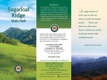
Our MissionSugarloafRidgeState ParkThe mission of California State Parks isto provide for the health, inspiration andeducation of the people of California byhelping to preserve the state’s extraordinarybiological diversity, protecting its mostvalued natural and cultural resources, andcreating opportunities for high-qualityoutdoor recreation.A rough smack of“resin was in the air,and a crystal mountainpurity . . . There aredays in a life whenthus to climb out of theCalifornia State Parks supports equal access.Prior to arrival, visitors with disabilities whoneed assistance should contact the park at(707) 833-5712. This publication is available inalternate formats by contacting:CALIFORNIA STATE PARKSP. O. Box 942896Sacramento, CA 94296-0001For information call: (800) 777-0369(916) 653-6995, outside the U.S.711, TTY relay servicewww.parks.ca.govSugarloaf Ridge State Park2605 Adobe Canyon RoadKenwood, CA 95452-9004(707) 833-5712(707) 938-1519 (District Headquarters)www.parks.sonoma.netPhotos on cover and inside panel courtesy of Diane Askew 1992 California State Parks (Rev. 2009)Printed on Recycled Paperlowlands seems likescaling heaven.”—Robert Louis Stevenson
Sugarloaf Ridge Statepoints from the slopesPark is named for the shapeof Mount Saint Helena.of the ridge at its southernThey traveled to theedge. In the 1800s, sugarcoast to gather salt,was molded into coneseashells and seaweed,shaped loaves; many hillsand traded with theand mountains with a conicalPomo people for itemsshape were whimsicallynot available locally.called “sugarloaf.” ThePerhaps 1,500 years4,020-acre park is locatedago, the Wappo settlednortheast of Kenwood inin the Alexander ValleyValley view from Bald Mountainthe Mayacamas Mountainsarea, building theirbetween the lush Sonoma and Napa valleys.homes from local materials. Their social structureElevations in the park range from 600 feet at theincluded chiefs who acted much like consultantsentrance to 2,729 feet at the top of Bald Mountain,with expertise in specific areas. For instance, ifoverlooking the Napa Valley and Mount Saintsomeone had a health problem, a chief wouldHelena to the north. On clear days, you can seeconsult someone with experience in medicinalthe Golden Gate Bridge and the Sierra Nevadacures. Family ties were of vital importance to thefrom Bald Mountain’s summit.Wappo, and they held their elders and children inTemperatures during spring and fall are mild.high regard.The wettest months—from November to April—The Wappo village, called Wilikos, was locatedcan bring 30 to 40 inches of rain. Wintertime lowsalong the upper reaches of Sonoma Creek beforecan drop into the 20s, but daytime highs averagethe first Spanish settlers came. Acorn grinding50s and 60s. Summer is hot and dry, often in therocks can be seen locally. Accomplished artisans90s, cooling to the 40s in the evenings. Wear a hat,and excellent resource managers, the Wappo wereand bring drinking water.known for their fine basketry and their expertise inAlong the creek near the entrance to thefarming techniques.campground, the visitor center provides generalinformation and a guide to the park’s natural andcultural history.When the Spaniards first tried to take their landsand resources, ca. 1823, the Wappo successfullyresisted. Before long, however, the people wereforcibly moved from their traditional lands toreservations, where they lived with other nativegroups. Despite theirstrongest efforts toretain their identity,Wappo cultureand languagewere largely lost.Today some Wappodescendants areWappo bead basketmaking an effort toPhoto courtesy of Phoebe A. Hearstrevive their spokenMuseum of Anthropology and thelanguage.Regents of the University of CaliforniaNATuRAL HISTORYThe park encompasses three distinct ecologicalsystems: chaparral-covered ridges, oak/fir woodlandalong the open meadows, and redwood forestin the Sonoma Creek canyon. Big-leaf maples,madrone, California laurels, gray pines and aldersalso grow here. California lilacs, coyote bush, toyon,and winebush make up some of the chaparralcommunity. As you hike, watch out for poison oakand, along the creek, stinging nettles.PARK HISTORYNative PeopleAnthropologists believe that the Wappo peopleare one of the oldest native California groups,descended from the first people to settle here.For thousands of years, they led fairly stable liveson lands that produced everything they neededto thrive. The Wappo gathered obsidian for arrowPanoramic view of Sugarloaf Ridge
Photo courtesy of Diane AskewPhoto courtesy of Diane AskewCanyon Trail waterfallSonoma Creek begins in the park and runs forthree miles through its southern portion. The creekis not deep enough for swimming and often driesup by late summer. Following the winter rains, apicturesque 25-foot waterfall flows along SonomaCreek below the campground. In the spring, thepark comes alive with wildflowers such as Californiapoppies, cream cups, penstemon, buttercups,shooting stars, trillium, and Indian warrior. Lesscommon are golden fairy lantern,zigadene and fritillaria. Clarkia, scarlet larkspur, Mariposa lilies, monkeyflowers and Indian pinks bloom inearly summer. Invasive yellowstarthistles and tarweed abound inlate summer.RANCHINgBy the 1870s, a number of settlerswere living in the hills near SugarloafRidge. Farming was limited andmarginal. One settler cut and slowlyburned trees to make charcoal thatwas sold in San Francisco. Eventually“gentlemen farmers” came to ownOld ranch barn Sugarloaf Ridge; hired managers rantheir ranches while they tended toother businesses in town.The State of California bought the propertyin 1920 to dam the creek and provide water forSonoma State Hospital, but neighbors along thecreek objected. Until World War II, the area wasused for camping, picnicking and a Boy Scout camp.In 1942 the land was leased for grazing,and it became part of the California State ParkSystem in 1964.RECREATIONCampingThe campground, located around the meadow nearSonoma Creek at an elevation of 1,200 feet, has49 campsites that can accommodate trailers andcampers up to 24 feet. Each site has a table and afire ring, with flush toilets and drinking water nearby.GThe group campground accommodates up to 50people. There is one large barbecue and fire ring,with water faucets and chemical toilets.PicnickingAcross the creek from the campground are picnicsites with tables, barbecues and day-use parking.FishingTrout fishing in Sonoma Creek is best in late springand early summer (the creek is not stocked). Fishingseason varies each year—please consult currentCalifornia Fish and Game regulations. Anglers overthe age of 16 must have a valid California fishinglicense.HikingThe park has 21 miles of trails that wind through thechaparral, oak and fir forest, and the redwoods inthe canyon along Sonoma Creek.THE ROBERT FERguSON OBSERVATORYThe dark night sky here makes this a perfect locationfor an observatory. Named after a Sonoma countyamateur astronomer, the observatory is locatednear the group campground and surrounded by aprotective ring of hills, decreasing the light pollutionfrom nearby cities. This astronomy observatoryhouses several telescopes. The observatory is opento the public on select weekends throughout theyear for both night and solar viewing. Per-personfees are charged at the door for night viewing.
accessibleThe visitor center and parking are generallyaccessible. Assistance may be needed withthe portable restroom at the visitor center. Forinformation on disabled access to the observatory,call (707) 833-6979 or visit www.rfo.org for details.PLEASE REMEMBERSchoolchildren enjoy the visitor center.Classes teach visitors about the night sky, howto make a telescope, and more. For informationor group reservations, call (707) 833-6979 or visitwww.rfo.org.PLANET WALKThis scale model of the solar system, designedto fit within Sugarloaf Ridge State Park, allowsyou to “hike” through the entire solar systemby shrinking it more than 2,360,000,000 times.Our sun is large enough to hold a millionEarths, yet it is only a middle-sized star. Atthe scale used for this model, the nearestneighboring sun is more than 10,000 miles away.Each step you take is equal to nearly onemillion miles of empty space.To begin your walk, start at the signrepresenting the sun in the southeast cornerof the observatory parking lot. If you take onestep every five seconds, you will be walking atthe speed of light, but plan on 1/2 to 2 hours foryour hike.Enjoy your journey! Pets must be controlled at all times. Theymust be on a leash no longer than six feet, andkept inside a vehicle or tent at night. They arepermitted in the campground and picnic area,but not on park trails or in the backcountryareas. Please clean up after your pets. Fires are allowed only in the fire rings provided.You may use your portable stove or barbecue,but only in the established camping and picnicareas. Wood gathering is not allowed—deadwood is part of nature’s recycling system.Purchase firewood at the entrance station. Smoking is limited to developed areas. Thepark becomes tinder-dry in summer when firehazard is high; please do not smoke on trails. Quiet hours are 10 p.m. to 6 a.m. Generators mayonly be operated between 10 a.m. and 8 p.m. Plants and wildlife are protected. Do not pickthe flowers. Theirseeds make nextyear’s flowers. For their welfareand your safety,please do notfeed or attempt topet wild animals.Please secure fooditems at night toObserve coyotes and allkeep raccoons fromwildlife from a distance.stealing them.MOuNTAIN BIKES Mountain bikes may only be ridden ondesignated fire roads and service roads. Maximum speed is 15 mph. If visibility is less than 50 feet, slow to walkingspeed. Alert trail users ahead of you ofyour approach. Yield to horses. See “Horses and Bicycles” rules.HORSES AND BICYCLES Horses and bicycles may only be ridden ondesignated, named trails. Stay on trails—Do not take “short cuts” or useunnamed trails. NEARBY STATE PARKS Annadel State Park6201 Channel Drive, Santa Rosa(707) 539-3911 Jack London State Historic Park2400 London Ranch Road, Glen Ellen(707) 938-5216 Sonoma State Historic Park363 3rd Street West, Sonoma(707) 938-9560This brochure was printed in cooperation withValley of the Moon Natural History Association2400 London Ranch RoadGlen Ellen, CA 95442www.jacklondonpark.com
need assistance should contact the park at (707) 833-5712. This publication is available in alternate formats by contacting: CALIFORNIA STATE PARKS P. O. Box 942896 Sacramento, CA 94296-0001 For information call: (800) 777-0369 (916) 653-6995, outside the U.S. 711, TTY relay service www.parks.ca.gov Sugarloaf Ridge State Park Our Mission