Transcription
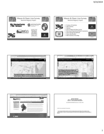
9/23/2019Mason & Dixon Line SurveyMason & Dixon Line SurveyNational Registry ProjectNational Registry ProjectMarylandPurpose of InventoryState PartnersStatutesParts of Mason & Dixon SurveyResurveys/Inspections/Historic InventoriesStone Numbering MethodsStone IdentificationMGS Inventory Form/AppWest VirginiaThe National Register of Historic Places is the official listof the Nation's historic places worthy of preservation.PennsylvaniaDelawareThe Delaware/Maryland Mason &Dixon Boundary Markers are currentlyincluded in the National Register ofHistoric Places in 1975.NATURAL RESOURCESTITLE 2. MARYLAND GEOLOGICAL SURVEYSUBTITLE 4. STATE BOUNDARY MONUMENTSMd. NATURAL RESOURCES Code Ann. § 2-402 (2017)§ 2-401. Joint ownership of monumentsAny monument which marks the common boundary between the State and any adjacent state,commonwealth, or district is the joint property of the State and the adjoining state, commonwealth, ordistrict.1
9/23/2019NATURAL RESOURCESTITLE 2. MARYLAND GEOLOGICAL SURVEYSUBTITLE 4. STATE BOUNDARY MONUMENTSNATURAL RESOURCESTITLE 2. MARYLAND GEOLOGICAL SURVEYSUBTITLE 4. STATE BOUNDARY MONUMENTSMd. NATURAL RESOURCES Code Ann. § 2-402 (2017)Md. NATURAL RESOURCES Code Ann. § 2-402 (2017)§ 2-402. Duty and authority of SurveyThe Survey shall examine, at least once every ten years, every monument which marks the boundaries ofthe State. Whenever the Survey finds the monument is lost, removed, or displaced causing the boundary tobecome obscure, inaccurate, or incorrect, it shall cooperate with the proper officials and agencies of theadjacent state, commonwealth, or district to replace, restore, or repair the monuments on the commonboundary line. The Survey, on behalf of the State, may make any joint agreement or contract withappropriate officials or agencies of any adjacent state, commonwealth, or district, and the United StatesCoast and Geodetic Survey, or any similar disinterested party or agency, to resurvey, remark, or otherwisedelineate more clearly any part of any common boundary between the State and any adjacent state,commonwealth, or district. In any resurvey, the present established boundaries of the State shall bepreserved with the greatest possible fidelity.§ 2-403. Survey's right of entry on landThe Survey (MGS) may enter on any public or private property to examine any boundary monument.However, the Survey may not enter during the growing season on any land planted with crops which mightbe damaged by any entry.Maryland Inventory of Historic Properties database2
9/23/2019Mason & Dixon Line “Original Survey”November 15, 1763 to September 11, 17684 years, 9 months, 27 daysMason & Dixon stones already included inMaryland Inventory of Historic Propertiesin 1980’s (Alice Martin)Limit of lines SurveyedPortion of Map prepared by Jeremiah Dixon after the Survey- Sideling “Sidelong” Hill5 degrees of longitudewestward from theDelaware Shore.(21.1 miles from Browns Hill)“North Line”“Tangent Point”(12 miles from New Castle)Parts of theMason & DixonLine Survey“West Line”“Tangent Line”Set at tops of high ridges and mountains-What is a Cairn?“Heaps of Earth or Piles of Stone Three Yards and ahalf Diameter (10.5 feet) at Bottom and five (5)feet High, None less, but many four yards Diameter(12 feet) Six (6) or Seven (7) feet High.”10.5 - 12 feet in diameter and 5 - 7 feet highMile posts west of Savage Mountain to the endof the line“Heaps of Earth or Stone Round them of Eight (8)feet Diameter at Bottom and 2 1/2 feet High.”8 feet in diameter and 2.5 feet high“North Line”From the journal of Charles MasonApril 26, 1766“Transpeninsula Line”(Surveyed in 1751 byColonial Surveyors andNOT by Mason & Dixon)Stones set before Sideling Hill,Cairns set afterResurveyThe Lieut. Col.James D. Graham1849-1850Resurveys and Inspections1849 to PresentFrom the TangentPoint to North Line toNortheast corner ofMaryland3
9/23/201918921850 Map of theLieut. Col. James D. Graham1850ResurveyResurveyThe C. H. Sinclair1885MarylandPennsylvaniaBoundary1900 – 1903From the Southwestcorner ofPennsylvania toNorthwest corner ofMarylandSet Stone 55 2/10 in old Mason & Dixoncairn, on top of high ridge, between MP 195and MP 196, USGS 222. 1,051 feet east ofSupreme Court 1910 three state corner.Northwest CornerMD-VA Deakins – 1788MD-VA Michler – 1859State of West Virginia - 1863PA-WV Sinclair – 1885MD-WV Brown-Bauer – 1897Supreme Court (Deakins) 19101850 Boundaries “Wedge” becomes partof Delaware in 1921Northern Border ofMaryland portionof Mason & DixonLineResurvey of the Maryland-Pennsylvania Boundary1900 - 1903 The Commission was appointed by the Legislatures of Maryland and PennsylvaniaResurvey was only for that length of Maryland’s northern border with PennsylvaniaResurvey did not include the Maryland – Delaware borderResurvey was not a relocation or correction of the Mason & Dixon LineResurvey was to replace missing stones, repair broken or damaged stones,straighten leaning stones and raise sinking stonesOriginal Mile/Crown stones, left at Fort Frederick by Mason & Dixon, were setNew stones (10” by 10”) were set in the “cairns” (stone and earth mounds) left byMason & Dixon along the western end of the line (west of Sideling Hill)Original stones were encased in a 3’ by 3’ by 3’ base of concreteTo make a topographic sketch map of the immediate vicinity of the boundary(original field notes with NGS)Resurvey ofthe MarylandPennsylvaniaBoundary1900 - 1903Beginning of multi numbering system.4
9/23/2019USGS numbering 1900 - 1903 Resurvey numberingFrom 1900-1903 Resurvey Report1900-1903 Resurveystarts with a difference of1 and is off by 4 at lastMason & Dixon stone 132USGS 135 M-D 131USGS 136 M-D 132USGS 137 M-D 132aUSGS 138 M-D 133a(Mason & Dixon number codes)Resurvey of the Maryland-Pennsylvania Boundary1900 - 1903Resurvey ofthe MarylandPennsylvaniaBoundary1900 - 1903Before ResurveyAfter Resurvey (Stone 90)(Between Blue Ridge Summit, PA and Highfield-Cascade, MD)Inspection1950-1959Report byWilliam H. Baylifffield work byDr. A. L. TrussellFirst Edition PublishedJanuary 1951Second EditionPublished May 1959Boundary Monuments on theMaryland-Pennsylvania andMaryland-Delaware Boundaries(120 pages)First Edition Published January 1951Second Edition Published May 19595
9/23/2019Crown Stone 80 (USGS 83) status at time of 1950 Inspection19501980Crown Stone 80Circa 1991?ResurveyResurvey1961-1962U.S. Coast andGeodetic Survey1974NationalGeodetic SurveyDuring the original 1751Survey stones were set every5 miles. In 1976 and 1981 theNGS set additional stones at1-mile intervalsInspection1980Buford K. Meade Reportof1961-1962 and 1974Resurveys1980Alice Martin(Stones added to MarylandInventory of HistoricProperties - MIHP)(314 pages)6
9/23/20191950Alice Martin 1980 ReportMile Stone 71Page 2 of 1319801991 - 2003Mile Stone 71T. Robert Bechtol1988 Report(Baltimore County)Mile Stone 46InspectionPage 10 of 211988-1989T. Robert Bechtol(Historical Society of Harford County)Crown Stone 20November 21, 2017Crown Stone 20T. Robert Bechtol1988-89 ReportLooking NorthLooking West at Penn CrestLooking East at Calvert Crest7
9/23/2019Inspection1991-1999LocationsMason & DixonLine PreservationPartnershipPost Marked West to Brown’s HillMASON & DIXON LINE PRESERVATION PARTNERSHIPMile Stone 66 (1991 to 96 )Stone was reported loose in 1991 visit and was found laying on sideduring a June 1996 visit. Location of base could not be found during1996 visit. A nail was set and located by GPS. Base found during10/12/1996 GPS session. Top reset loose on base.N 39 43’ 11.99950” W 77 01’ 56.84628”NAD 83 positions, but no metadata1948Almost every Mile Stone located fromStone 0 (NE corner MD) to Stone 141Most inspected and very few located fromStone 141 to Brown’s Hill19801950Mason & Dixon Line SurveyCairns set19911991Stones set5 degrees of longitudewestward from theDelaware Shore.(21.1 miles from Browns Hill)- East side of Sideling Hill(Mason & Dixon 132)“Here we could proceedno farther with the waggons.”Charles Mason, April 26, 1766Dated 1766 -1767 for cairn anddated 1902 for “Resurvey” stoneAFTER SIDELING HILL (Mason & Dixon 132)13 “Fort Frederick” found stones set67 Cockeysville Marble mile stones set1 Cockeysville Marble crown stone setDuring the 1900-1903 Resurvey, 10 “found” original M-D MPstones were set, 3 “found” original CS were set and 1 “replica”CS was set after the M-D Stone 132. The rest were 10” by 10”monuments with the dates “1766” or “1767” on the east sideand “1902” marked on the west side.8
9/23/2019Stone numbering/coding (kmz file)M-D Stone 132M-D 132aC Resurvey(137)CSM-D 133a Resurvey(138)MPM-D 132aC Resurvey(137)CSM-D 134b Resurvey(140)MP Approx.M-D Stone 132(Last M-D carved Stone set, begin stone/earth cairns)“(OCS)” Original Crown Stone“(OMP)” Original Mile Post“(Rep CS)” Replica Crown Stone“M-D Stone” Mason & Dixon Stone“132” Stone number 132Stone numbering/coding (kmz file)Stone numbering/coding (kmz file)M-D Stone 132M-D 132aC Resurvey(137)CSM-D 133a Resurvey(138)MPM-D 132aC Resurvey(137)CSM-D 134b Resurvey(140)MP Approx.M-D Stone 132M-D 132aC Resurvey(137)CSM-D 133a Resurvey(138)MPM-D 132aC Resurvey(137)CSM-D 134b Resurvey(140)MP Approx.M-D Stone 132aC Resurvey(137)CS“132aC” 1st Stone (a) set during 1900-1903 Resurvey after the Mason & Dixonnumber 132 and placed in an original Mason & Dixon Cairn.“(137)” Stone set during 1900-1903 Resurvey with the USGS numbering of 137“CS” Stone is a Crown Stone Penn Crest on north side and Calvert crest on south sideM-D Stone 133a Resurvey(138)MP“133a” 1st Stone (a) set 1900-1903 Resurvey after Mason & Dixon mile 133 cairn“(138)” Stone set during 1900-1903 Resurvey with the USGS numbering of 138“MP” Original (1767) Mile Post marker with “P” on north side and “M” on south sideStone numbering/coding (kmz file)M-D Stone 132M-D 132aC Resurvey(137)CSM-D 133a Resurvey(138)MPM-D 132aC Resurvey(137)CSM-D 134b Resurvey(140)MP Approx.M-D Stone 134b Resurvey(140)MP Approx.“134b” 2nd Stone set during 1900-1903 Resurvey after Mason & Dixon 134 cairn“(140)” Stone set during 1900-1903 Resurvey with the USGS numbering of 140“MP” Stone is a Mile Post marker with “P” on north side and “M” on south side“Approx.” Position is approximate, No coordinate determined during MDLPP work“NGS” Coordinates from National Geodetic Survey disk in stone“MDOT” Coordinates provided by the Maryland Department of Transportation“Replacement” Replica Crown stone set in 1902 (from HSP or MdHS)“2002” Year a new stone was set for a missing one, MDLPP“Missing” Not found during MDLPP inventory9
9/23/2019Stones known to have been removed from the line.M-D Stone 10 - Plumpton Park ZooM-D Stone 40a - York County History Center(1416 Telegraph Road, Rising Sun, MD)(250 East Market Street, York, PA)Stones known to have been removed from the line.Stones known to have been removed from the line.M-D Stone 50 - Maryland Historical SocietyM-D Stone 65 - Maryland Geological Survey(201 W. Monument Street, Baltimore, MD)(2300 St. Paul Street, Baltimore, MD)Stones known to have been removed from the line.M-D 181cResurvey 201Photo 4/13/1984(Mark Folk PropertySprings, PA)M-D Stone 110 - Crown Stone Farm (barn)M-D Stone 115 - Historical Society of Pennsylvania(14748 Fairview Road, Clear Spring, MD)(1300 Locust Street, Philadelphia, PA)M-D 134b (OMP) Resurvey 140Christ Church Cemetery(498 Arch Street, Philadelphia, PA)Stone Identification“Which side is it?”“Who set it?”“Is it oriented the right way?”Mason and Dixon original (1760’s) Crown StonesMason and Dixon original (1760’s) Mile Post StonesFort Frederick “stash” used west of Mile 132 and “fill-in”1900 – 1903 Resurvey (1902) Replica Crown Stones (50 & 158a)1900 – 1903 Resurvey (1902) Mile Post Stones2002 Replica Crown Stone at Mile 752003 MDLPP Replacement Stones2015 Replica Crown and Mile Post StonesMason & DixonOriginal Crown StonePA (North) Side1900-1903 ReplicaCrown Stone10
9/23/2019Mason & DixonOriginal Crown StoneMason & Dixon OriginalMile Post StoneMD (South) SidePA (North) Side1900-1903 ReplicaCrown Stone1900-1903 ReplicaMile Post StoneMason & Dixon OriginalMile Post Stone1900-1903 ReplicaMile Post StoneReplica Crown Stone at mile 75 (2002)Between Mile 46 and Mile 472003 MDLPP Replacement Stones, some have been setMD (South) SideNext to Crown Stone 40Replica Crown and Mile Post Stone (2015)11
9/23/2019Survey123 appWhen you first open the surveySurvey123 appWhen you tap the satellite iconSTATE/COUNTIES ON THE MASON & DIXON LINESurvey123 appAfter you complete the surveyand tap the check EEN ANNE’SCAROLINEDORCHESTERWICOMICOWORCESTER *DELAWARENEW CASTLEKENTSUSSEXWEST VIRGINIAPRESTONMONONGALIAWETZEL ** - County on a portion of the line surveyed by others and not Mason & Dixon12
9/23/2019MASON & DIXON LINE INVENTORYStones (per county) in MDLPP database (Mason & Dixon 0 to 199a)PENNSYLVANIACHESTER - 19LANCASTER - 5YORK - 43ADAMS - 24FRANKLIN - 35FULTON – 18*BEDFORD – 28**SOMERSET – 45*FAYETTE - 12GREENEMARYLANDCECIL - 24HARFORD - 20BALTIMORE - 12CARROLL - 22FREDERICK - 14WASHINGTON - 49ALLEGANY - 39GARRETT - 43WEST VIRGINIAPRESTON - 4MONONGALIAWETZELMason & Dixon Line SurveyQUESTIONS* - Stone at/near common county border13
MASON & DIXON LINE PRESERVATION PARTNERSHIP Mile Stone 66 (1991 to 96 ) 1948 1950 1980 1991 1991 Mason & Dixon Line Survey "Here we could proceed no farther with the waggons." Charles Mason, April 26, 1766 Stones set-East side of Sideling Hill (Mason & Dixon 132) 5 degrees of longitude westward from the Delaware Shore. (21.1 miles from .


![[403] Vol. Cccxxxviii Over the Counter Sales 3.40 Including G.s.t .](/img/27/22195-gazette-11-may-2022.jpg)