Transcription
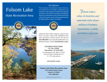
Our MissionFolsom LakeState Recreation AreaThe mission of California State Parks isto provide for the health, inspiration andeducation of the people of California by helpingto preserve the state’s extraordinary biologicaldiversity, protecting its most valued natural andcultural resources, and creating opportunitiesfor high-quality outdoor recreation.Folsom Lake’smiles of shoreline andwaterside trails attractmillions of boaters,equestrians, cyclists,California State Parks supports equal access.Prior to arrival, visitors with disabilities whoneed assistance should contact the park at(916) 988-0205. If you need this publication in analternate format, contact interp@parks.ca.gov.CALIFORNIA STATE PARKSP.O. Box 942896Sacramento, CA 94296-0001For information call: (800) 777-0369(916) 653-6995, outside the U.S.711, TTY relay servicewww.parks.ca.govFolsom Lake State Recreation Area7755 Folsom-Auburn RoadFolsom, CA 95630(916) 988-0205 2008 California State Parks (Rev. 2016)and hikers each year.
Folsom Lake StateRecreation Area offersscenic panoramasof open grasslands,rolling hills, the SierraNevada, SacramentoValley, and the BayArea’s Mount Diablo.Folsom Lake StateScenic viewsRecreation Areacovers 19,500 acres. Its two reservoirs,Folsom and Natoma, attract about twomillion visitors annually.The climate is typical of Sacramento area.Hot summers require a sunhat and sun block.In winter, fog brings a chill. Spring and falloffer rainy or warm days with cooler eveningsand nights.PARK HISTORYNative PeopleFor thousands of years, the land nearFolsom Lake belonged to the SouthernMaidu or Nisenan (“from among us”).The Nisenan lived in temporary summershelters made from peeled tree bark. Inwinter they dwelled in permanent villageson the American River. These villageshad community buildings, including kumceremonial and guest structures.The Nisenan traded with other nativegroups, exchanging local acorns for blackoak acorns, manzanita berries, and sugarpine nuts. Coastal people traded with theNisenan for oyster shells, shell beads, andbasket materials. The Nisenan are still knownworldwide for their woven baskets made fromwillow, redbud, tule, milkweed, sedge grass,and native grapevines.After the 1848 gold discovery, most ofthe Nisenan lands were given away asSpanish land grants. The native peoplewere overwhelmed by the loss of their foodsources and by diseases like smallpox. TheNisenan people were nearly decimated,but today their descendants live in nearbycommunities or on reservations.FOLSOM DAMFolsom Lake was created in 1955 by theconstruction of Folsom Dam, a concretedam flanked by earth wing dams and dikes,with a total length of about nine miles. Theshoreline extends about 15 miles up theforks of the American River. Lake levelnormally varies from 460 feet in earlyspring to less than 400 feet by summer.Downstream, behind Nimbus Dam, smallerLake Natoma has about 500 surface acres ofwater. Built by the Bureau of Reclamationas part of California’s Central Valley Project,Nimbus and Folsom Dams control the watersof the American River and provide floodprotection, household water supply,power, and irrigation.THE FOLSOM POWERHOUSENearby Folsom Powerhouse was builtto harness the water power of theAmerican River at the original FolsomDam, completed by Folsom Prisonlaborers in 1893. The Powerhouselandmark, listed on the NationalRegister of Historic Places, is a statehistoric park.PLANTS AND WILDLIFEBlue oaks, interior liveoaks, foothill pines, andannual grasses dot theopen woodlands. In thespring, blooming wildflowersinclude Indian paintbrush,larkspur, lupine, brodiaea, fiddleneck,dutchman’s pipe, and monkey flower.Black-tailed deer, raccoons, skunks,opossums, gray foxes, and coyotes are oftenseen in the park. Mountain lions and bobcatsmay occasionally be spotted. Beaversand river otters live in the Mormon IslandWetlands, a perfect area for bird watching.Nesting egrets, herons, and cormorantsmay be observed from the Willow Creekaccess. Year-round residents include Canadageese, blackbirds, scrub jays, quail, wrens,bushtits, and towhees. Wrentits and Californiathrashers sing in the chamise-chaparral. Lookfor kingfishers and grebes near the water.Red-tailed hawks, kestrels, ospreys, andeagles might be seen soaring over the lake.Folsom Lake and Dam
Photo courtesy of Sacramento State Aquatic CenterRECREATIONfrom the town of Pilot Hill onHighway 49.Fishing — FolsomBeals Point CampgroundLake waters holdJust north of Folsom Dam,trout, catfish,Beals Point has 49 familylargemouth andcampsites and 20 RV hookupsmallmouth bass,sites for trailers and motorperch, and kokaneehomes up to 31 feet. Asalmon. A validsanitation station, pipedCalifornia fishingdrinking water, and wheelchairlicense is required.accessible restrooms with hotLake Natoma’sshowers are available nearby.accessible pier andfishing platform is atNimbus Flat.Boating — Launchingfacilities are locatedWindsurfing on Folsom Lakeat several placesaround the lake (see map for details).The marina at Brown’s Ravine also featuresboat slips, a towing service, a gas dock, andsnack bar.CAUTION: Boaters should be alert forfloating debris. Watch carefully forunderwater hazards, especially when thelake level is very low. Observe speed limits.Horseback riding trails at Folsom LakeCampingNegro Bar Group Campsites — On the northPeninsula Campground—A hundred familyshore of Lake Natoma, three group campsitescampsites— some accessible—accommodateare available. Two can hold up to 50 peopletrailers up to 18 feet and motor homes up toeach and one can accommodate up to24 feet. A sanitation station is provided. No25 people.site hookups are available. Accessible flushReservations—Reserve campsites at alltoilets, hot showers, and piped drinking watercampgrounds by calling (800) 444-7275 orare available. Two launch ramps and a dayvisiting www.parks.ca.gov.use area are near this secluded campgroundBoat Camping — You may camp overnightat the end of the Peninsula between the northaboard your self-contained sailboat orand south forks of the American River. Reachpowerboat only in designated mooring areas.the area by boat or drive ten miles southObtain a map of the mooring areas whenregistering for boat camping at the GraniteBay entrance station or the marina at Brown’sRavine. If no one is available when you arrive,contact park headquarters. Your boat musthave self-contained sanitary and gray-watersystems with sleeping accommodationsfor all aboard. You may camp ashore at thePeninsula Campground only in a designatedcampsite. Beach the bow of your boatand anchor off the stern. A secure tie-upis essential, as the wind may rise duringthe night. Boat camping is limited to twoconsecutive nights.Picnicking — Family picnic sites are locatedat Willow Creek, Nimbus Flat, and Negro Baron Lake Natoma, and at Beals Point, Brown’sRavine, Granite Bay, the Peninsula area, andFolsom Point on Folsom Lake. Beals Point,Nimbus Flat, and Peninsula have accessiblepicnic tables,restrooms,and parking.All sites havebarbecues;bringcharcoal.The grouppicnic area atGranite Bayholds up to200 people.Reserve bycalling (916)988-0205.Lake Natoma accessiblepicnic area
Darrington Trail is a popular mountain biketrail on the south fork of Folsom Lake, nearSalmon Falls.Beach / Shore Access — Call ahead to reservea beach wheelchair for two hours at the BealsPoint or Granite Bay day-use areas.Nimbus DamACCESSIBLE FEATURESAccessibility in California State Parks iscontinually improving. For specific details,visit www.access.parks.ca.gov.Photo courtesy of Sacramento State Aquatic CenterHorseback Riding — Horse trailers canunload and park at several equestrian stagingEXHIBITS / PROGRAMSareas. Granite Bay has hitching rails, a waterThe American River Water Education Centertrough, and chemical toilets. Other staginginterprets water conservation and theareas are located at Negro Bar, RattlesnakeAmerican River Watershed. For information,Bar, Brown’s Ravine,call (916) 989-7100; forOld Salmon Falls,tours, call (916) 989-7132Falcon Crest, andor see www.usbr.gov/Sterling Pointe.mp/arwec.Trails — The parkAQUATIC CENTERhas 95 miles ofThe Sacramentotrails for hikers,State Aquatic Centerbicyclists, runners,offers boat rentalsand horsebackand boating safetyriders. The trailclasses. The facility issystem includes thecooperatively operatedPioneer Expressby California State Parks,Trail, which is partits Division of Boatingof the 50-mileand Waterways, and theWestern States/Canoeing at Lake NatomaAssociated StudentsPioneer Expressof California StateNational RecreationUniversity,Sacramento.For schedules,Trail. Oaks Nature Trail is accessible.call (916) 278-2842 or visitA paved, mostly accessible bicycle trailwww.sacstateaquaticcenter.com.loops around Lake Natoma, linking to BealsPoint and the American River Bike Trail.NEARBY STATE PARKS Folsom Powerhouse State Historic Park9980 Greenback LaneFolsom 95630(916) 985-4843 Auburn SRA501 El Dorado St.Auburn 95602(530) 885-4527PLEASE REMEMBER Grass, brush, and trees become tinderdry. Wildfires are a serious threat. Firesare allowed only in the camp stoves orfire rings provided. Poison oak is presentthroughout the park. Evenwhen dormant, poison oakcan cause a serious rash. Rattlesnakes, mountain lions,or bobcats may be present inthe park. Do not walk alone inPoison Oakisolated areas. Reportsightings to park staff. Floating debris, an uneven lake bottom, androck outcroppings are hazards for boatersand swimmers. Swim only in designatedareas. No diving is permitted. All cultural and natural features areprotected by law and may not bedisturbed or removed.
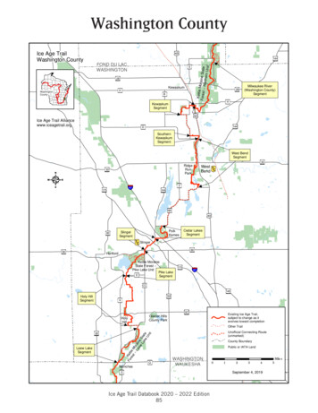
onrkPiorthNesTrailRattlBlvdFolsom0’’60ll s kRoMo0’800’toPlacerville50’toPlacervilleThis park receives support in partfrom a nonprofit organization.For more information, contactFriends of Lakes Folsom and NatomaP.O. Box 257, Orangevale, CA 95662www.folfan.orgFreewayCampground: RVMajor RoadFishingPaved RoadFood ServicesTrail: AccessibleHorse Staging AreaTrail: Hike & BikeMarinaAccessible FeatureRoadPark HeadquartersTrail: Hike & HorseTrail: Multi-UseRock200’ik e Trail201200ericanmhSoutrmanIslretMain AvenueGetScott RoadNimbus FlatPDarrington600’800’600’Auburn - Folsom Road0’40RoForraS ieSierra College BoulevardHazel AvenueMain Avenuetreoadch RadBlvlSadmillselRototy0’do HEl DoradwIronPoint RoadCikaeNWillow PawstrieHazelSophiaEL �VaMORMONISLANDWETLANDSNATURALPRESERVENatoma reekT raille yto RanchoCordovaSibrBAlderCreekFoueBltiveican RAmerLaSacramento StateAquatic Centeree60MississippiBarNimbus DamOverlookNimbus Dam50ySWShadow GlenRiding StablesWinding Waycan RivereriAmleFAIR OAKSStCovedR oalleymaNatoRiMadison AvenueatomNaRainbow BridgeFolsom Powerhouse SHP0’Greenback LaneSunset eenback dgkSkunk HollowRiver AccessSweRevine TrandFolsomFolsom Lake CrossOaSalmonFalls RaftTake-outNew YorkCreek CoveBrown’s RavineFolsom LakeMarinam20Brown’sLakeOak AvenueSalmonFallsBridge800’600800’ ’POldSalmonFallsFolsomDaOak AvenueSouth Fork TrailP600’kF orilTrasspreExBealsPointPark 00AAmerican River WaterEducation Center200’RiverPreeonPi’Douglas Boulevard00Granite BayGranite BayActivity Center’004 laCampgroundDotonsPointnC re e k02.5 MilesadkOaksNatureTrailOakPoint2.0BarkenaPGRANITE BAY1.5600’C r ON OLSOM LAKE0Wild GooseFlats14600’65Brown’s Ravine Staging Area . 3.2New York Creek . 9.7Old Salmon Falls . 14.2Sweetwater Creek . 14.8Salmon Falls Bridge . 17.4Peninsula Entrance Rd (RattlesnakeBar Road) . 27.0SpringsCollege B oulevardSterlingPointeLomida Lane400’toLincolnFrom Folsom Point to:IndianROCKLINHorseshoe Bar’’0014Negro Bar Staging Area .4.5Rainbow Bridge. 5.0Beals Point.9.2Pioneer Express Trail Historic Monument .9.5Douglas Boulevard . 13.1Granite Bay Staging Area. 14.2Beeks Bight . 16.7Horseshoe Bar . 20.1Rattlesnake Bar Staging Area. 23.7Auburn Staging Area . 34.4’oad16’80SOUTH FORK ARMTRAIL MILEAGE600’From Nimbus Overlook (Hazel Ave.) to:00aRtoColomaPPIONEER EXPRESS TRAIL MILEAGElom0’Rattlesnake Bar0’12Co491400o40PILOTHILL’Road’Bar Road’’1400snaKing RoadFolsomLake SRA16Rattlesnake800’Salmo80050600’1200Rke5 99to LakeTahoeFolsomPowerhouseSHPsRoad0’emlsoFo lvdB8060Trail1200tt uburnSRA1400800RoadAuburnCollegeLincolnto SanFrancisco0’rraSie6570800’8015 Km10600’50White99toReno4910 00801200mloCoState Recreation Area00AUBURNnFolsom Lakemlso’0080800’12800’1200600’Auburn Dam site1400’toTruckee193400’Boat Launch: HandBoat Launch: VehicleBridgeCampgroundCampground: GroupPParkingPicnic AreaPicnic Area: GroupRestroomsRestrooms: FloatingRV Sanitation StationSwimmingTrailhead 2010 California State Parks (Rev. 2016)
need assistance should contact the park at (916) 988-0205. If you need this publication in an alternate format, contact interp@parks.ca.gov. CALIFORNIA STATE PARKS P.O. Box 942896 Sacramento, CA 94296-0001 For information call: (800) 777-0369 (916) 653-6995, outside the U.S. 711, TTY relay service www.parks.ca.gov Folsom Lake State Recreation Area