Transcription
Total Control, Simply Refinedwww.furuno.comBeware of similar productsApple, Apple logo, are trademarks of Apple Inc., registered in the U.S. and other countries.App Store is a service mark of Apple Inc.Android and Google play logo are trademarks of Google Inc.All brand and product names are registered trademarks,trademarks or service marks of their respective holders.SPECIFICATIONS SUBJECT TO CHANGE WITHOUT NOTICEFURUNO ELECTRIC (MALAYSIA)SND. BHD.FURUNO ELECTRIC CO., LTD.FURUNO DANMARK A/SFURUNO FRANCE S.A.S.FURUNO EURUS LLCFURUNO U.S.A., INC.FURUNO SVERIGE ABFURUNO ESPAÑA S.A.FURUNO SHANGHAI CO., LTD.FURUNO PANAMA S.A.FURUNO FINLAND OYFURUNO ITALIA S.R.L.FURUNO CHINA CO., LTD.FURUNO (UK) LIMITEDFURUNO POLSKA Sp. Z o.o.FURUNO HELLAS S.A.FURUNO SINGAPOREFURUNO NORGE A/SFURUNO DEUTSCHLAND GmbHFURUNO (CYPRUS) LTDPT FURUNO ELECTRIC INDONESIAJapan www.furuno.comU.S.A. www.furunousa.comRepublic of Panama www.furuno.com.paU.K. www.furuno.co.ukNorway www.furuno.noDenmark www.furuno.dkSweden www.furuno.seFinland www.furuno.fiPoland www.furuno.plGermany www.furuno.deFrance www.furuno.frSpain www.furuno.esItaly www.furuno.itGreece www.furuno.grCyprus www.furuno.com.cyRussian Federation www.furuno.ruMalaysia www.furuno.myChina www.furuno.com/cnHong Kong www.furuno.com/cnSingapore www.furuno.sgIndonesia www.furuno.id10-H-1811PDFCatalogue No. CA000001294
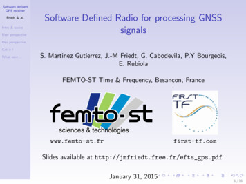
Simply Refined, Simply Beautiful Edge-to-edge glass front Sunlight viewable multi touch display with impressivebrightness, 1300 cd/m2 for TZTL12F and 1000 cd/m2for TZTL15F Add Autopilot, Instruments, Radar, AIS, and a wide variety ofother sensors to your NavNet TZtouch2 network An instrument display like nothing you have seen before,totally customizable, totally simple Seamless, smooth chart operation with TimeZero Technology Connect up to 6 NavNet TZtouch2/TZtouch displays on onenetwork, 4 when connecting a TZT2BB Black Box Enhanced touch gestures like edge swiping for frequentlyused functions With an Internet connection, NavNet TZtouch2 can wirelesslyaccess real-time weather data The graphical user interface has been renewed and refined,focusing on usability and ease of operation Internal GPS Antenna (TZTL12F/15F) Tablet & Smart phone apps:NavNet Remote, NavNet Viewer and NavNet Controller for youriOS and Android devices Internal RezBoost Fish Finder Compatible with CZone Digital Switching15.6" Multi Function Display12.1" Multi Function Display Fast processor (CPU) for great performances (TZT2BB) Manual Fuel Management enabling visual evaluation of fuelamountResolution: FWXGA (1366 x 768 pixels)Brightness: 1000 cd/m2 (typical)Resolution: WXGA (1280 x 800 pixels)Brightness: 1300 cd/m2 (typical) Independent display and operation for dual screens withbuilt in dual CPU (TZT2BB) Full HD HDMI video input available (TZT2BB)NMEA2000CertifiedNEWMulti Function Display Black BoxSupports both wide and non-wide resolutions:1920 x 1080 (16:9), 1280 x 1024 (5:4),1024 x 768 (4:3)SD Card Unit (option)for TZTL12F/TZTL15FMulti Touch Marine Display* with TZT2BB Processor Unit (Model MPU-004)and Control Unit** (Model MCU-005)* Local supply** OptionRemote Control Unit (option)Remote Control Unit (option)Switch Boxfor TZT2BBNEWControl Unit (option)* TZTL12F/15F: Software version 6.01 or later12
For Safe CruisingRadar functionsTarget Analyzer Manual Fuel Management*Target Analyzer function displays help you distinguish targets that are moving and getting close to own ship.The NavNet Series calculates and displays the remaining fuel based on the manually entered tank capacity,as well as fuel consumption information from an NMEA2000 network. The gauge allows the user to evaluatethe price fuel level without equipping the ship with a fuel gauge. By configuring the settings, an alarm isavailable to inform you when the fuel level is low.* 1) NMEA2000 PGN127489 (Fuel Rate) input is required.2) NavNet TZtouch software version 4.01 and NavNet TZtouch2software version 6.0 or later required.3) While the engine is running, at least one NavNet model in thenetwork should always be turned on in order to keep calculatingthe fuel consumption.4) The fuel indication may be inaccurate if the values entered are notcorrect, or the fuel rate sensor is not functioning correctly.Target modeData boxManual Fuel Tank display in Instrument modeRain mode* Target Analyzer available when connected to DRS4D-NXT or DRS6A-NXT Radar sensor.** NavNet TZtouch2 software version 3.01, TZtouch software version 4.21 or later required.Integrate YAMAHA outboardswith NavNet SeriesFast Target Tracking (TT)CPA graphic displayAfter selecting a target, it only takes a few seconds for a speed andcourse vector to be displayed. With accurate tracking information,estimation of other vessels course and speed is made easier.The CPA graphic display lets you monitor an AIS and ARPA (TT) targetsheading and speed changes. This is useful as an anti-collision aid,especially in congested waters.The YAMAHA graphic interface displays status inforation ofengines (up to 4), and ship information can be controlledfrom the NavNet TZtouch2 via YAMAHA Command Link ,Command Link Plus and Helm Master interfaces.* For more details about the list of compatible engines, pleasecontact us or YAMAHA representatives.Quater displayFull displayFor SailingAutopilot Control WindowThe new autopilot control window on the instrument page and data area offers quick and easy control of the NAVpilot Series, includingsteering operation and mode selection. With the NAVpilot-300, you can also initiate Turn/Fish Hunter operation, adjust manual parametersand carry out installation setup from the NavNet TZtouch2 MFDs.NMEA20003Autopilot functionsNEW01 Laylines*Based on the direction and speed of thewind, the shortest route is calculated.NEW02 Polar File*NEWIn order to display accurate Laylines,Polar Files can be imported to the NavNetTZtouch2. Polar Files of various boat models areavailable for download from NavNet.com.03 Historical Graph*NEWWind speed and direction can be visualizedon the Historical Graph. In addition, the AirPressure will be useful for your long cruising.* NavNet TZtouch2 software version 6.0 or later required.4
For FishingRadar functionsThe ACCU-FISH algorithm analyzes echo returns in orderto compute individual fish size. The algorithm is capable ofcomputing fish size ranging from 10 cm up to 199 cm long.Fish depth can also be displayed.Vessel heading toward flocksBird ModeBottom Discrimination DisplayThe bird mode helps you identify birds congregating aroundschools of fish at the sea surface.The bottom discrimination function provides you with valuableinformation to help you locate rich fishing grounds to boostthe day's catch.* NavNet TZtouch2 software version 3.01,TZtouch software version4.21 or later required.Two flocks of birdsScroll-backWith RezBoost technology, high resolution and targetseparation previously limited to FURUNO commercial-gradeFish Finders can now be achieved. RezBoost technologymakes it easier to spot individual fish in tightly packed fishschools, as well as discerning game fish from bait fish.* RezBoost performance may vary depending on depth, range andsignal frequency used.TruEcho CHIRP TruEcho CHIRP Fish Finder allows for incredible performancewhen it comes to detecting fish close to the seabed, as well asdiscriminating individual fish in densely packed schools of fish.* Network Fish Finder DFF1-UHD required.High Frequency CHIRPWhite EdgeThe edge of the seabed is displayed in white to easily discernseabed structure from bottom fish returns.Low Frequency CHIRPFound a fishing hot spot? Simply tap the screen and add afish mark. With the scroll-back feature, you can look at pastechoes simply by swiping the screen, and add new fishmarks that will show the captured location on your plotterscreen.Other functionsFish Finder functionsBuilt-in Fish Finder with RezBoost NEWFish Finder functionsACCU-FISHTM (Fish Size Analyzer)Monitoring Sea Surface TemperatureSea surface temperature (SST) is one of the most importantpieces of information for fishing in order to find the best spotor area.Track RecordingTrack Recording by SST Variation draw a ship's track invariable colors, helping you find the location of a bigtemperature change or shear.Shear AlarmThe Shear Alarm lets you know when there is a sudden change in sea surface temperature,often caused when two currents meet. This is usually a good indication of a great fishing spot.* NavNet TZtouch2 software version 6.0 or later required.SST GraphSST Graph on the fish finder display, instrument display or data box shows you the history of SST in the trip.56
For ship condition monitoringand expandabilityAPPSView information on your smart devices via wireless networkNavNet TZtouch2 open the door to cutting edge Wireless LANfeatures, such as iOS and Android apps, real-time weather data,software updates and much, much more.CZone Digital SwitchingCZone digital switching by BEP simplifies the installation andoperation of complex electrical systems. NavNet TZtouch2 iscompatible with CZone controls, allowing you to operateCZone equipment.NavNet Remote App* Lean more about CZone Digital Switching at www.czone.netCZoneCZone Control & MonitoringNMEA2000Take full control of your NavNet TZtouch2 in a wholenew way. The NavNet Remote app allows you toremotely operate and view your system with your smartdevices when connected to the Wireless LAN network.CZone, engine, navigation and various NMEA2000data can be laid out on the same screen.Marine Audio FUSION-LinkNavNet Viewer AppEnjoy the ability to control all FUSION-Link enabled Apollo/755/750/700series marine entertainment system capabilities and functions directly fromthe NavNet TZtouch Series. FUSION-Link makes it easy for you to enjoy youronboard audio and video entertainment from the NavNet TZtouch Series.Conventiently view instruments as well as the fish finder of yourNavNet TZtouch2 on your smart devices over the Wireless LANnetwork. Key navigational information such as Depth, Temp, Wind,COG as well as Engine information can all be accessed from thepalm of your hand. Even if you change the display on your NavNetTZtouch2, you can still view the Fish Finder on your smart devices.NavNet Controller AppMarine Weather ForecastWirelessly control the NavNet TZtouch2 with touchcontrols just like the real thing. With a scroll pad,cursor pad and dedicated keys within the app,controlling the NavNet TZtouch2 is simple andstraightforward.The weather tool is completely free and easy to use, giving youunlimited access to weather forecasts, worldwide, 24 hours a day,provided by NavCenter. NavNet Series can display up to 16 days ofdownloaded weather forecasting.* Internet connection is required.My TimeZero Cloud Data ServiceConnect your NavNet TZtouch2 to the internet and login to your My TimeZero account, and you will be able to back up or restore points, routes, tracks andsettings to/from the cloud server.Compatible NavNet productsLanguages7NavNet RemoteNavNet ViewerNavNet ControllerNavNet TZtouch2 (TZTL12F/TZTL15F/TZT2BB)- software version 4.01 or later.NavNet TZtouch2 (TZTL12F/TZTL15F/TZT2BB)NavNet TZtouch2 (TZTL12F/TZTL15F/TZT2BB)English/Japanese8
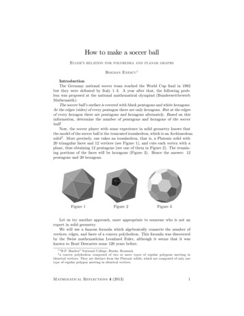
Perfect match!NavNet TZtouch2 NetworkNavNet TZtouch2, NAVpilot-711C and the FI-70 have been designed to matcheach other beautifully, both in appearance and in function. Sporting a clean andfunctional design in all black, they will make a great addition to your helm.NAVpilot-711CNavNet TZtouch2FI-70NEWNEWRADARAUTOPILOTRadar SensorNEWDRS4DL /DRS4D-NXT/DRS6A-NXTDRS6A X-Class/DRS12A X-ClassDRS25A X-ClassNAVpilot-300EthernetCAN busNAVpilot-711CNAVpilot-700CAN busNMEA0183CAN busNMEA0183NEWNEWFISH FINDERCOMPASSNetwork Fish FinderDFF1-UHD/DFF1/DFF3Integrated Heading SensorSatellite CompassBottom Discrimination SounderMulti Beam N busCAN busNMEA0183EthernetAISGPSAIS ReceiverClass-B AIS TransponderClass-A AIS tGPS/WAASReceiver AntennaGPS NavigatorCAN busCAN busGP-330BNMEA0183GP-33NEWWEATHER/PC PLOTTERTIMEZEROMarine SoftwareNetwork WeatherFacsimile ReceiverNetwork Satellite Weatherand Radio MMUNICATIONOTHERSInternal GPS AntennaMarine Entertainment SystemApollo Series, etc.Analog CameraIP CameraDigital Switching SystemEthernetVideoEthernetCAN busNEWHDMI*2Marine VHF RadiotelephoneMarine VHF RadiotelephoneFM-4850FM-4800CAN busCAN busINSTRUMENTInternal Fish Finderwith RezBoost technologyFI-70CAN busNEWCONVERTERNMEA Data ConverterAnalog NMEA Data ConverterIF-NMEA2K2IF-NMEAFICAN busNMEA0183CAN bus*1 Sirius weather coverage is currently available only in U.S and Canada. Sirius subscription required.*2 TZT2BB only.9NavNet TZtouch2 is NMEA2000 certified.NMEA2000 offers improved data transferrates and true plug-and-play operation.OPTIONControl UnitRemote Control UnitRemote Control UnitSD Card UnitMCU-005MCU-004MCU-002SDU-001USBUSBUSBUSB* TZTL12F/TZTL15F; Software version 6.01 or later.10
Nothing Is Faster Than TimeZero Chart PlotterNavNet TZtouch2 TimeZero technology delivers chart processingMapmedia Vector and Raster Chart Librarylike you’ve never seen before – seamless chart handling, zooming andpanning without the screen disappearing. TimeZero technologyredefines the meaning of stress-free operation by smoothing out yourchart handling actions.With NavNet TZtouch2 it’s possible to freely choose the chartsthat fit your individual needs. With the optional NOAA raster andvector charts, Mapmedia brings an authentic vector and rasterchart library to your NavNet TZtouch2. “C-MAP” as well as“Datacore by Navionics” vector cartography are optional chartsthat can be downloaded to your TZtouch2 with ease. Mapmediacartography integrates cutting edge algorithms with highresolution image processing techniques to deliver a fusion ofdigital navigation charts and satellite photography.2D RasterThe Only Acceptable Wait Time is Zero:TimeZero Technology Changes Your Perspective on Chart RedrawEquipped with powerful TimeZero technology, NavNet TZtouch2 will completely transform the way you navigate.You can scroll, pan, zoom in/out with a smooth, fast and seamless graphics engine. Navigating in a 3D environmentoffers you a true perspective and wider area of view around the ship, which allows you to better plan your routes.TimeZero technology updates the information on your screen with virtually no redraw as you go.2D VectorSatellite PhotoFusion Satellite photography is included in the Mapmedia Raster andVector charts, simply called Satellite PhotoFusion . Land areas(zero depth) are completely opaque, displayed as satellitephotos on the chart. As the depth increases, the satellite imageis merged with the chart data to provide you with added detailon seabed areas in shallow water, without losing vital chartinformation. In deeper water, where the satellite photos have nodetail to offer, the chart is displayed without alteration.Raster SatelliteVector SatelliteDepth ShadingA depth color scale can be applied to both 2D and 3D vectorand raster charts. Transparency levels can be adjusted so thatchart data is visible beneath the color shading. This uniquefeature allows you to view water depths at-a-glance with vibrantcolors. No more searching for depth numbers, when you cansimply set depths to your specified colors. Whether you want tosee the depth for navigation or fishing purposes, this featuremakes it easier than ever before.AIS Target TrackingWhen connecting a FURUNO FA-30/50/170 AIS unit to yourNavNet TZtouch2, up to 100 AIS targets can be tracked anddisplayed on the Chart Plotter screen. The Automatic IdentificationSystem (AIS) improves safety during travel by sharing the statusand position of your vessel with other AIS-equipped vesselsnearby. You can easily read detailed information aboutAIS-equipped vessels nearby such as speed, heading, ClosestPoint of Approach and Time to Closest Point of Approach.1112
Fish FinderNavNet TZtouch2 is the first product from FURUNO to feature the brand new RezBoost technology. Accurately spot individual fish and increase your catch.RezBoost Rezboost is a revolutionary new technology utilizing FURUNO’s advanced digital signalprocessing to provide fantastic resolution without having to change your transducer.Multi Beam SonarInnovative tool for exploring a wide range ofwater column and seabedNew Multi Beam Sonar model DFF-3D gives you real-time 120port-starboard view of the water column and seabed up to 200 mdepth*. The DFF-3D allows you to explore fishing spots and find fish indeep water by far faster than conventional single beam sounders. Onthe other hand, the main beam penetrate right under the boat at a depthof approximately 300 m*. Installation is made easy, thanks to a compacttransducer design. The built-in motion sensor gives you clear imagesunder your boat even in rough water.Scanning image of Multi Beam Sonar* Maximum depth dependent on installation, bottom type and water conditions.Up to 8 timessharper image thanconventional FDF*1Conventional Signal ProcessingRezBoost Signal ProcessingRezBoost improves target separation close to the seabed, as well as giving anunprecedented boost in resolution. With RezBoost technology, resolution and targetseparation previously limited to FURUNO commercial-grade Fish Finders can now beachieved. RezBoost technology makes it easier to spot individual fish in tightly packedfish schools, as well as discerning game fish from bait fish. Since RezBoost technology is software based, you can use transducers* already installed on your vessel.* To check if your transducer supports the “Enhanced Mode”, see FURUNO.com for further information.In-hull mounted transducers not compatible with RezBoost technology.*1 RezBoost performance may vary depending on depth, range and signal frequency used.3D historySide ScanFind More Fish With TruEcho CHIRP Fish FinderAn advanced technology for both professional and enthusiast fishermen. Designed to operate across a wide rangeof frequencies utilizing a broadband transducer, the TruEcho CHIRP network fish finder delivers significantadvantages in signal clarity and target definition. Due to the constant sweep of frequencies the TruEcho CHIRP network fish finder is capable of gathering more and higher quality data than a traditional single frequency fishfinder. The clear presentation marks individual game fish and bait fish, even when tightly schooled together.FURUNO Digital Filter (FDF ) Fish FinderFURUNO Digital Filter (FDF ) fish finders feature advanced filtering capabilities and digitalauto tuning, which eliminates noise. FURUNO FDF fish finders deliver the ability to spotindividual fish with clarity, accuracy and detail. Whether in shallow or deep water,FURUNO FDF fish finders give you what you would expect from a fish finder at all times.ACCU-FISH (Fish Size Analyzer)Up to 10 timessharper image thanconventional FDF*2High Frequency CHIRPThe ACCU-FISH algorithm analyzes echo returns in orderto compute individual fish size. The algorithm is capable ofcomputing fish size ranging from 10 cm up to 199 cm long.Fish depth can also be displayed.In some instances, fish size indicated on the NavNet TZtouch2 may differ from itsactual size. Please carefully read the operator’s manual prior to utilizing this feature.BLACK BOX NETWORK FISH FINDERFrequencyBottom Discrimination DisplayBottom discrimination provides detailed information aboutKnowing the make-up of the seabed, categorizing it into fourdifferent categories; “Rocks”, “Gravel”, “Sand” and “Mud”.The make-up of the seabed can be tremendously helpfulinformation when looking for fishing grounds, as well as forfinding good anchoring spots.13Low Frequency CHIRP*2 TruEcho CHIRP performance may vary depending on depth, range and signal frequency used.Range ScaleTransducers3D ModeACCU-FISH Bottom DiscriminationTruEcho CHIRP RezBoost Display ModeInternal Fish FinderDFF1-UHDDual frequency50kHz and 200 kHzDual frequency50 20 and 200 25 kHzUp to 1,200 m600 W or 1 kW*1 kWN/AAvailable**BLACK BOX NETWORK FISH FINDERBLACK BOX NETWORK MULTI BEAM SONARDFF3DFF-3DThe synthesized transducer workswith dual frequencies between28 and 200 kHzUp to 3,000 m1, 2 or 3 kWAvailableN/AAvailableAvailableN/AN/AN/AAuto (Fishing/Cruising/Manual), Bottom Zoom, Bottom Lock, A-Scope165 kHzUp to 1,200 m800 WAvailableN/AN/AN/ATriple/Single Beam Sounder,Side Scan, Cross Section,3D historyDFF1/BBDS1 are fully compatible with NavNet TZtouch2.*Matching Box MB-1100 required for some specific FURUNO transducers.** For DFF3, with 50/200-1T transducer only.14
RadarModelARPA Target TrackingDRS25A X-ClassModelModelWith ARPA Target Tracking enabled, up to 30 different targets* canbe tracked simultaneously. Targets can be acquired either manuallyor fully automatically. Automatic Radar Plotting Aid (ARPA)calculates the tracked objects course and speed, as well as theCPA (Closest Point of Approach). With this information, the Radar iscapable of predicting possible collision courses and sound relevantalarms. In combination with AIS, this spells increased security andease of mind on your vessel.DRS12A X-ClassDRS6A X-ClassNEWModel*100 different targets with DRS-NXT Series.DRS4DL NEWModelReal-Time Digital Auto Gain/Sea ControlsNavNet TZtouch2 employs revolutionary real-time digital autoGain/Sea controls to deliver a crystal clear radar presentation.With this new technology, NavNet TZtouch2 computes and appliesan adaptive omni-directional anti-clutter filter with variable intensityaccording to vessel bearing. With the use of this technology,automatic gain and sea clutter have achieved such a high level ofproficiency that one rarely needs to venture into the manual modes.Set the Radar to auto and focus on more important things at hand.DRS6A-NXTRadar SensorsModelDRS4D-NXTWinner of the NMEA awards2008, 2009, 2010, 2011,2012, 2013, 2014 and 2015Auto Gain/Sea Controls OnSimultaneous Dual Range Radar ScanningExclusive DRS4D-NXT featuresThe NXT step in Radar technologyAuto Gain/Sea Controls OffSimultaneous scanning technology sends out a dual progressivescan that is processed and presented on the NavNet TZtouch2.This technology allows for two different radar ranges to be displayedsimultaneously, each range with autonomous control over gain andanti-clutter settings.New Target Analyzer function*Solid-State Radar with pulse compression, Target Analyzer and FastTarget Tracking utilizing Doppler technology. Combined with FURUNOexclusive RezBoost technology for echo sharpening.Not available on DRS4DL , Limited to 12 NM on DRS-NXT Series.* TZtouch2 software version v3.01 or later for DRS4D-NXT, version v5.01 or later for DRS6A-NXT.AIS Target TrackingWith Target Analyzer, hazardous targets are displayed in redWhen connecting a FURUNO FA-30/50/170 AIS unit to the NavNetTZtouch2, up to 100 AIS targets can be tracked and displayed onthe Radar screen. The Automatic Identification System (AIS)improves safety during travel by sharing the status and position ofyour vessel with other AIS-equipped vessels nearby. You can easilyread detailed information about AIS-equipped vessels nearby suchas speed, heading, Closest Point of Approach and Time to ClosestPoint of Approach.X-Class series a whole new class of RadarPushing the boundaries of what is possible withconventional Radar technology, X-Class series mark yetanother leap forward for FURUNO. Improved in almost allaspects, X-Class Radar features improved short rangedetection as well as an impressive long range detectionof up to 96 nautical miles. And that's not all, the new“Bird Mode” gives you incredible bird detectionperformance.NavNet TZtouch2 Radar Sensor Options*1 TZtouch2 software version v3.01 or later.*2 Bird mode is also available with DRS-NXT Series.The radar detects and distinguishes several small yatchs with high accuracy.Bird ModeDRS4DL Output PowerSizeAntenna TypeBeam WidthVessel heading toward flocksMax. Range48 rpm CapabilityTwo flocks of birdsDRS X-Class SeriesFunctionsBird mode and navigation mode can both be displayed via a simultaneous dual modescanning. Possibility to track the birds while navigating safely.15HorizontalVerticalTarget AnalyzerDual Range ScanningFast Target Tracking MFD version requiredDRS6A X-ClassDRS12A X-ClassDRS25A X-Class4 kW19 inchDRS4D-NXTSolid-state, 25 W24 inchDRS6A-NXTSolid-state, 25 W6 kW3.5 ft/4 ft/6 ft3.5 ft/4 ft/6 ft12 kW4 ft/6 ft25 kW4 ft/6 ftRadomeRadomeOpenOpenOpenOpen5.2 3.9 1.9 /1.35 1.9 /1.35 2.3 /1.9 /1.35 2.3 /1.9 /1.35 25 25 22 /22 22 /22 22 /22 /22 22 /22 /22 36 NM36 NM96 NM96 NM72 NM96 NM— Head-up, North-up*,Head-up, North-up*,Head-up, North-up*,Head-up, North-up*,Head-up, North-up*,Head-up, North-up*True Echo Trail, Bird mode, True Echo Trail, Bird mode, True Echo Trail, Bird mode, True Echo Trail, Bird mode, True Echo Trail, Bird mode,True Echo Trail,TT, AISTT, AISTT, AISTT, AISTT, AISTT, AIS———— — (Range is limited to 12 NM) (Range is limited to 12 NM) 5.013.015.013.014.014.01* Heading input required.The radar antenna complies with IEC62252 Ed. 1:2004 (Clauses 4.33, 5,33, Annex D) relevant to radio characteristic.16
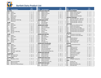
3"SpecificationsBracket is optional supply.TZTL12FMULTI FUNCTION DISPLAYDISPLAY UNITTypeScreen SizeScreen ResolutionScreen BrightnessTZTL15FTZT2BBMULTI FUNCTION DISPLAY BLACK BOXDISPLAY UNITColor TFT multi touch LCD12.1" Wide15.6" WideWXGA 1280 x 800FWXGA 1366 x 7681000 cd/m2 (typical)1300 cd/m2 (typical)Chinese, Danish, English (USA/UK), Finnish, French, German, Greek, Italian, Japanese,Norwegian, Portuguese, Russian, Spanish, SwedishLanguageGPS/WAASReceiver TypeReceiving FrequencyTime to First FIXTracking VelocitySBASACCURACYInternal AntennaCHART PLOTTERCartgraphyMemory CapacityAlarmsRADARDisplay ModesEcho TrailTarget TrackingFISH FINDER (Built-in)Transmit FrequencyTransducerModesINTERFACECAN bus/NMEA2000Signal InterfaceDisplay ColorsLanguageCHART PLOTTERCartgraphyGPS: 56 channels, SBAS: 1 channel (C/A mode, WAAS)L1 (1575.42 MHz)100 s (cold start)999 knWAAS, EGNOS, MSASAlarmsRADARDisplay ModesEcho TrailTarget TrackingFISH FINDERTransmit FrequencyTransducerDisplay RangeMapMedia mm3d chart (C-MAP/Navionics/NOAA)30,000 user points, 30,000 points for ship's tracks, 200 planned routes (500 points per route)Anchor Watch, XTE, Proximity, Depth, Temperature, Speed, etc.Head-up, North-up* *Heading input required.Interval: 15 s, 30 s, 1 min, 3 mins, 6 mins, 15 mins, 30 mins and continuous30 Targets*, 100 Targets (with DRS-NXT Series) *Heading input required.InputInterface(CAN bus/NMEA2000)1 Port065280, 126992, 126993, 126996, 127237, 127245, 127250, 127251, 127257, 127488, 127489, 127505, 128259, 127267, 129025, 129026,126029, 126033, 126038, 126039, 126040, 126041, 126291, 126538, 126540, 129793, 129794, 129798, 129801, 129802, 129808, 129809,129810, 130306, 130310, 130311, 130312, 130313, 130314, 130316, 130577, 130578, 130817, 130818, 130820, 130822, 130823, 130826,130827, 130828, 130880126992, 126993, 126996, 127250, 127251, 127257, 127258, 128259, 128267, 128275, 129025, 129026, 129029, 129033, 129283, 129284,129285, 130306, 130310, 130312, 130313, 130314, 1303161 Integrated Output PortAAM, APB, BOD, DBT, DPT, GGA, GLL, GNS, GSA, GSV, RMB, RMC, RTE, TLL, TTM, VTG, WPL, XTE, ZDA1 Port (100BASE-TX)1 Port (USB2.0)Input: 2 Ports (NTSC/PAL), Output: 1 Port (HDMI)1 Port (External Event/MOB Input/Operator Fitness/Alarm Output)1 Slot (Micro SDXC, rear), 2 Slots Card Unit: Model SDU-001 (option)IEEE802.11b/g/n, Transmit frequency: 2.4 GHz band1 PortOutput50/200 kHz600 W or 1 kW* *Matching box MB-1100 required for some FURUNO transducers.2-1, 200 m, shift: 0-500 mRezBoost , ACCU-FISH , Bottom Discrimination, A-Scope,Auto (Fishing/Cruising), Bottom Zoom, Bottom Lock8 steps: x4, x2, x1, 1/2, 1/4, 1/8, 1/16, stopExtension Mode600 W or 1 kW* *Matching box MB-1100 required for some FURUNO transducers.RezBoost , ACCU-FISH , Bottom Discrimination, A-Scope, Auto (Fishing/Cruising), Bottom Zoom, Bottom LockNMEA0183Interface (NMEA0183)OutputLANUSBVideo I/OAUX I/OSD Card SlotWireless LANTransducerENVIRONMENTTemperature (IEC60945)WaterproofingPOWERHead-up, North-up* *Heading input required.Interval: 15 s, 30 s, 1 min, 3 mins, 6 mins, 15 mins, 30 mins and continuous30 Targets* 100 Targets*, (with DRS-NXT series) *Heading input required.Picture AdvanceINTERFACECAN bus/NMEA200050/200 kHzInputMapMedia mm3d chart (C-MAP/Navionics/NOAA)30,000 user points, 30,000 points for ship's tracks,200 planned routes (500 points per route)Anchor Watch, XTE, Proximity, Depth, Temperature, Speed, etc.Memory CapacityGPS: 10 m Max, WAAS: 3 m Max, MSAS: 7 m MaxInterface(CAN bus/NMEA2000)Color LCD with touch panel control, FHD 1920 x 1080 recommended,XGA 1024 x 768/SXGA 1280 x 1024 availablePicture: HDMI, Extended, HDCP Touch panel: USB2.0, Windows 7 multi-touchChart Plotter/Menu: 16,770,000 colors Fish Finder: 64 colors Radar: 64 colorsChinese, Danish, English (USA/UK), Finnish, French, German, Greek, Italian, Japanese,Norwegian, Portuguese, Russian, Spanish, SwedishTypeOutputNMEA0183Interface (NMEA0183)OutputLANUSBHDMI I/OVideo InputSD Card SlotWireless LANTransducerENVIRONMENTTemperature (IEC60945)Processor unitWaterproofingSwitch boxControl unit (option)POWER-15 C to 55 CIP561 Port065280, 126992, 126993, 126996, 127237, 127245, 127250, 127251, 127257, 127488, 127489, 127505, 128259, 127267, 129025,129026, 126029, 126033, 126038, 126039, 126040, 126041, 126291, 126538, 126540, 129793, 129794, 129798, 129801 129802,129808, 129809, 129810, 130306, 130310, 130311, 130312, 130313, 130314, 130316, 130577, 130578, 130817, 130818, 130820,130822, 130823, 130826, 130827, 130828, 130880126992, 126993, 126996, 127250, 127251, 127257, 127258, 128259, 128267, 128275, 129025, 129026, 129029, 129033, 129283,129284, 129285, 130306, 130310, 130312, 130313, 130314, 1303161 integrated output portAAM, AP
as well as fuel consumption information from an NMEA2000 network. The gauge allows the user to evaluate the price fuel level without equipping the ship with a fuel gauge. By con guring the settings, an alarm is available to inform you when the fuel level is low. * 1) NMEA2000 PGN127489 (Fuel Rate) input is required.