Transcription
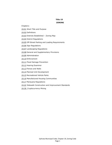
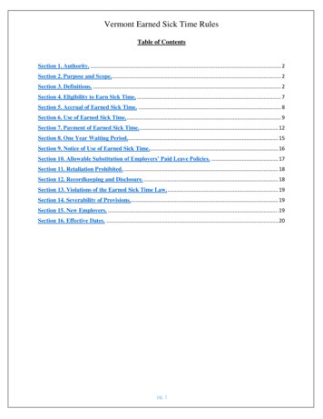
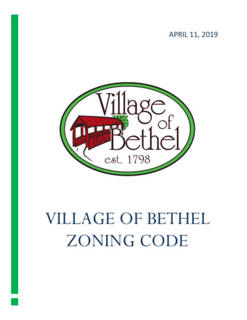
SAINT PAUL ZONING DISTRICTSSection LineWaterRL One-Family Large LotGROVEPARKLAUDERDALENATURE AREAR1 One-FamilyR2 One-FamilyR3 One-FamilyR4 One-FamilyRT1 Two-FamilyHoyt Ave WGrantham StVPRM2PD Planned DevelopmentCA Capitol Area JurisdictionRM2B2kLangBlakebs teAvEnergT2RM2BrewsterRM2StCathlin StLANGFORDPARKoSteAvT1 ComStellardGoAveidellsHiT2Knapp StdStoneAvT1GibmmCoI2 General IndustrialI3 Heavy IndustrialKnapp PlPlI1 Light IndustrialVP Vehicular ParkingT1lthIT Transitional IndustrialT1R3aweCleveland Ave NVPB5 Central Business ServiceFifielBourne AveB2B4 Central BusinesshStrCOLLEGEPARKB3 General BusinessRaleigrteCaeAvB2 Community BusinessStKeston StHighway 280eta AvKasoRT2T2BC Community Business (converted)RM1ScudderRM2 RT1veell AB1 Local BusinessB2PlDoswOS Office-ServiceT2AveRM1Chilcombe AveonBufordR3T3 Traditional NeighborhoodT4 Traditional NeighborhoodlrPhetLuValentine AveT2 Traditional NeighborhoodT3M T3 with Master PlanRaymond AveT1Gordn AveHythe StHendoGoveBrompton StEustis StHunting Valley RdI2T1 Traditional NeighborhoodRM1RT2OSRM2 Multiple-FamilyDudley AveB ranstonT2RM1 Multiple-FamilyRM3 Multiple-FamilyStI1RT2Fulham StB3Chelmsford StT1RT2 TownhouseU OF MN ST 252630 31273306601" 1/8 mile (660 feet)PANEL 128 29321,320FeetZONING LAST UPDATED MAY 8, 2014
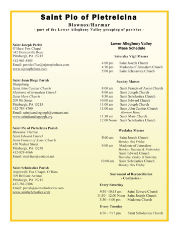
RM2Holton StB1Milton St NChatsworth St NOxford St NDunlap St NGriggs St NR3T3M T3 with Master PlanT4 Traditional NeighborhoodHamline Ave NOS Office-ServiceB1 Local BusinessBC Community Business (converted)B2 Community BusinessB3 General BusinessB5 Central Business ServiceIT Transitional IndustrialI1 Light IndustrialI2 General IndustrialPltoin gLe xAidaI3 Heavy IndustrialVP Vehicular ParkingnMid way PkwyokyNPkwRM2DrPD Planned DevelopmentCA Capitol Area JurisdictionLAKECOMOlEstabronPVPvdBloC omWAlmond AveAlbany AveRM2Horton AveRM2Vanvice Rd WRM2Churchill StS erBrewster StBeulah Lnl i ngWynne AveB2RM3RT1SlyR4keAveDrBreda 324252630 31273306601" 1/8 mile (660 feet)Kilburn StB3Argyle StComo AveWinston StT1 Traditional NeighborhoodB4 Central BusinessSn e lI1RM3 Multiple-FamilyT2 Traditional NeighborhoodDroNa sSnelling Ave NanufmKaAveTILDENPARKRM2 Multiple-FamilyerMidway Pkwy Service Rd SCanfield AveRM1 Multiple-FamilyComoCo moLakeDrBisMidway Pkwy Service Rd NRM2RT2 TownhouseT3 Traditional NeighborhoodonB2RT1 Two-FamilyMontana Ave WMary LnCOMO GOLFCOURSER4 One-FamilyIowa Ave WDrveR3 One-FamilyNevada Ave WSheldon StPascal St NnAR2 One-FamilyIdaho Ave Wbau mNusArona SttySSTATEFAIRGROUNDSR1 One-FamilyEAsbury StArlington Ave WFranksoRL One-Family Large LotBlvd ESimpson StR4M ckin leFair PlWaterAlbert St NNebraska Ave WSection LineHoyt Ave WChelsea StHuron StMerrill StCURTISSFIELDLarpenteur Ave WCalifornia Ave WFernwood StRM2B2B2SAINT PAUL ZONING DISTRICTSPANEL 228 29321,320FeetZONING LAST UPDATED MAY 8, 2014
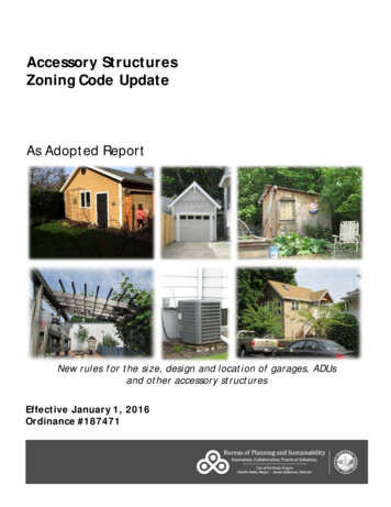
SAINT PAUL ZONING DISTRICTSRM2California Ave WLarpenteur Ave WB2RM2Colne StT4 Traditional NeighborhoodRT1OS Office-ServiceB2 Community BusinessRice St175'ICohansey StRT2B3 General BusinessB4 Central BusinessIT Transitional IndustrialC onservatory CtKent StRM2T3M T3 with Master PlanRM2RM1I1 Light IndustrialI1T2I2 General IndustrialI3 Heavy IndustrialIvy Ave WVP Vehicular ParkingPD Planned DevelopmentDanforth StCA Capitol Area JurisdictionB3B1RT1R4OSRose Ave WRT1Woodbridge StB3Marion StRM2Farrington StICumberland StLOEBLAKEMaryland Ave WNorton StMARYDALEPARK165.41'Virginia StRT1Arundel StMaywood StFolsom StMackubin StSchletti StDale St NSaint Albans St NGrotto St NNR4B1R3B5 Central Business ServiceIStOsag e StEComo BlvdDr EComo LakeRT1T3 Traditional NeighborhoodBC Community Business (converted)Wheelock Pkwy WT2RM2RM3 Multiple-FamilyB1 Local BusinessIonAvRM2RM2Como AveRM2 Multiple-FamilyR4R2Orange Ave WGate way DrRM1 Multiple-FamilyArlington Ave WRM2Ryde StNebraska Ave WCottage Ave WR4RT2 TownhouseT2 Traditional NeighborhoodNStLakeview AveRT1 Two-FamilyT1 Traditional NeighborhoodiaR3R4 One-FamilyB2B3Galtier StorctViParkview AveR3 One-FamilyAlbemarle StR4OSR1 One-FamilyR2 One-FamilyRM1B1 VPRL One-Family Large LotB3Western Ave NAlameda StHoyt Ave WWaterRM2Matilda StFisk StMilton St NELMHURSTCEMETERYIowa Ave WMontana Ave WR4RM1VPIdaho Ave WNevada Ave WB3Section LineB3 B1B2T2 B3Geranium Ave WRM2Jessamine Ave W0123456789101112131415161718192021222324252630 31273306601" 1/8 mile (660 feet)T2B2B3PANEL 328 29321,320FeetZONING LAST UPDATED MAY 8, 2014
Edgemont StRT1Wheelock Pkwy WRM2Sloan StIowa Ave WB3R3Wheelock Pkwy EHoyt Ave WBiglR1owLnR3 One-FamilyR4 One-FamilyRT1 Two-FamilyRT2 TownhouseHo yt Ave ERT2R2 One-FamilyIowa Ave ERM2RM2RT1Montana Ave EKlainert StR4R3Idaho Ave ERT1RM1Montana Ave WR2RL One-Family Large LotR1 One-FamilyB2DrR2WaterCalifornia Ave ERM1 Multiple-FamilyB1RM2 Multiple-FamilyRM3 Multiple-Family109ParB3Timberlake RdB2RM2Wanda StRM2Section LineRM1RM2II'IIB3Larpenteur Ave EkwayLarpenteur Ave WSAINT PAUL ZONING DISTRICTST1 Traditional NeighborhoodB1Nebraska Ave ET2 Traditional NeighborhoodT3 Traditional NeighborhoodT3M T3 with Master PlanNevada Ave ERM2Hyacinth Ave WB3IeAvBurr StderainrBRM2Geranium Ave WR1B3I1Agate StPayne AveIT Transitional IndustrialI1 Light IndustrialClear AveI2 General IndustrialI3 Heavy IndustrialVP Vehicular ParkingPD Planned Development123456789101112Hawthorne Ave E131415161718192021222324252630 3127330660B3RT1VPRose Ave ERM2 RT2VPRT1B2Jessamine Ave ERM1CA Capitol Area JurisdictionOrange Ave EGeranium Ave ERM2RT1B5 Central Business ServiceB3RM2Bradley StI1Abell StB3Maryland Ave EB4 Central BusinessHyacinth Ave EClark StSylvan StPark StT2B2R4Rose Ave WJessamine Ave WIT2RT1B3Old Maryland AveB3 General BusinessIvy Ave ERM1RdB1Maryland Ave WSearle StDesoto StIacrpB2RM2B2NoHawthorne Ave WI2B1R4134.12'Orange Ave WEdgerton StWestminster St150.15'Cottage Ave EJessie Stnt StLorieT2RM2Mississippi StJackson StIvy Ave WRT1ARLINGTON/ARKWRIGHTPARKArkwright StTrout Brook CirMayre StRice StI1B2 Community BusinessSherwood AveInterstate 35ECottage Ave WB1 Local BusinessBC Community Business (converted)IRM2OS Office-ServiceR3Arlington Ave EArlington Ave WT4 Traditional NeighborhoodMagnolia Ave E01" 1/8 mile (660 feet)PANEL 428 29321,320FeetZONING LAST UPDATED MAY 8, 2014
Larpenteur Ave ERT1Iowa Ave ElenChamber StPhaIdaho Ave EDuluth StParkwPHALEN KELLERREGIONAL PARKBrighton PlDrPHALENGOLFCOURSEMontana Ave ENebraska Ave EEaR3RM2stNevada Ave EShoreRM2R1 One-FamilyR2 One-FamilyR3 One-FamilyR4 One-FamilyRT1 Two-FamilyRT2 TownhouseRM1 Multiple-FamilyRM2 Multiple-FamilyRM3 Multiple-FamilyT1 Traditional NeighborhoodT2 Traditional NeighborhoodT3 Traditional NeighborhoodDrT3M T3 with Master PlanRT1T4 Traditional NeighborhoodOS Office-ServiceArlington Ave EWheelock PRM2Clear AveRT1kwyEB2 Community BusinessRT1IT TransitionalIIndustrialI1 Light IndustrialI2 General IndustrialI3 Heavy IndustrialVP Vehicular ParkingpicToPD Planned DevelopmentLnHyacinth Ave EtyAveCA Capitol Area Jurisdiction0wyPkRM2B1Magnolia Ave EMag noJessamine Ave EITR2123456789101112131415161718192021222324252630 31273306601" 1/8 mile (660 feet)Phalen Blvdl i a LnSts onJo h nLane PlT2tquisRT1RT2B2Rose Ave EProsperiB2B3Geranium Ave ET2Earl StMaryland Ave EnBurVPRM1Cypress StB2RT2RM2R4Frank StHawthorne Ave ET2Weide StOrange Ave EForest StMendota StArcade StWalsh StVPRT1B4 Central BusinessIB5 Central Business ServiceB2RT1RM1Ivy Ave ESUEPARKB3 General BusinessRT2Barclay StCottage Ave EWinchell StMcafee StT2Birmingham StClarence StBC Community Business (converted)ISherwood AveB1 Local BusinessIWheelock AveGreenbrier StRL One-Family Large LotHoyt Ave ERM1Atlantic StLAKEPHALENWaterFROSTLAKEPARKFROSTLAKEEnglish StayDrISLANDSection LineEtna StCalifornia Ave ERT1Manton StRM2SAINT PAUL ZONING DISTRICTSRM1RM1PANEL 528 29321,320FeetZONING LAST UPDATED MAY 8, 2014
RT2B3WaterIdaho Ave ER4 One-FamilyRT1 Two-FamilyHoyt Ave ER2RT2White Bear Ave NWinthrop St Ness PkwyI1 Light IndustrialVan Dyke StVP Vehicular ParkingPD Planned DevelopmentCA Capitol Area Jurisdictionnveen ATilsOrange Ave EB2I1RT1IGeranium Ave E150' IRM2'150'IR3lvde150Rose Ave EJessamine Ave EvsANokomiRT1150' IRM2Kingsford StHerbert Stes AveAmI3 Heavy IndustrialHyacinth Ave EBreen StRT1I2 General IndustrialIMagnolia Ave EIT Transitional IndustrialILnJessam ineB5 Central Business ServiceIRM1B4 Central BusinessStMaryland Ave ELnrnickpoSuB3 General BusinessHawthorne Ave EB1T2BC Community Business (converted)R3Ivy Ave ERM1RT2B1 Local BusinessseRM1OS Office-ServicerPedeHEBREWCEMETERYHazelwood StB2PROSPERITYHEIGHTSPARKT3 Traditional NeighborhoodClear AveRM2RM1T2 Traditional NeighborhoodT4 Traditional NeighborhoodR4Cottage Ave ER3T1 Traditional NeighborhoodB2 Community BusinessLuella St NIR3B2RM3 Multiple-FamilyRuth St N125'Sherwood AveHazel St NperiFlandrau StItyAIProsIArlington Ave EB2Kennard Stve125'RT1RM2 Multiple-FamilyT3M T3 with Master PlanOSIRM1 OSB2RT2RM1RM1 Multiple-FamilyFurnGermain StNevada Ave ENebraska Ave EB3VPHILLCRESTCOUNTRYCLUBRT2 TownhouseHazel StDieter StT2RM2 MontanaAve EVPOSBarclay StVPR3 One-FamilyMcknight Rd NB2R2 One-FamilyDavid StOSRM2VPR1 One-FamilyR3Gary PlRM3Iowa Ave ERL One-Family Large LotEdgewaterBProCalifornia Ave ESection LineDarlene StPlistierhCCraig PlityRdRT2sperRT1SAINT PAUL ZONING DISTRICTSLarpenteur Ave EBEAVERLAKE PARK0123456789101112131415161718192021222324252630 31273306601" 1/8 mile (660 feet)PANEL 628 29321,320FeetZONING LAST UPDATED MAY 8, 2014
tEverett CtManvelSR2 One-FamilyEndRdSticottRT1 Two-FamilyRT2 TownhouseRM1 Multiple-FamilyRM2 Multiple-FamilyStRM3 Multiple-FamilyRM2RM3VPI1AveB2 Community Businesstoh elnRM2DesnoyeB5 Central Business ServicePlR3rAvely RdDoane AveI1 Light IndustrialI2 General IndustrialI3 Heavy IndustrialRT1Minnehaha Ave WVP Vehicular ParkingPD Planned DevelopmentCA Capitol Area JurisdictionVan Buren AveR4I1RM2merytgotateThomas AveI294MonIntersR4IT Transitional IndustrialEnglewood AveBlair AveCleveland Ave NcBeverB4 Central BusinessAveStntenaB3 General BusinessLafond AveGlendale StFroClifford StI2B1 Local BusinessBC Community Business (converted)ITWabash AvePelham BlvdPrior Ave NveWTransfer RdityAAveLasalleMyrtleUniversOS Office-ServiceHubbard AveCCha rlesT4 Traditional NeighborhoodR4Pennock AveVandalia StCromwell AveT3T3M T3 with Master PlanCLAYLANDPARKHewitt AveEllis AveT3 Traditional NeighborhoodWheeler St NHersey StBradforAveT2 Traditional NeighborhoodNEWELLPARKFairview Ave NdTaylor AveClayland StalRtI2Tatum SttoriB2AveffSPierce Butler RteHowell St NTerriSaint Anthony AveT1 Traditional NeighborhooddVPpdenWycliStIT3T2gFranklinI AveT4R4 One-FamilyStWHamLonRM2R3 One-FamilyI1Carl et on0'lBayl ess PHuntPlAveB2Seal StEustis StWersityCurfew StBerry StiveRL One-Family Large LotCappRM2Highway 280UnWaterRM2Aveons Cirs tgate Drl StPearSection LineEnergy Park DrR1 One-FamilylessB ayCommJeStR4ffersonEmerald StRobbinsRM2RaymondAveRM2T3SAINT PAUL ZONING DISTRICTSRM2I2tPillsbury SR3I1T3T3Oakley 61718192021222324252630 31273306601" 1/8 mile (660 feet)ityAveWT3T4PANEL 728 29321,320FeetZONING LAST UPDATED MAY 8, 2014
Jessamine Ave WEnergy Park DrEnergy LnT2Pierce ButlerR teHolton StOSGreen StArgyle StKilburn StRM1 Multiple-FamilyRM2 Multiple-FamilySTINSONPARKStinson StRM3 Multiple-FamilyT1 Traditional NeighborhoodT2 Traditional NeighborhoodBurgess StT3 Traditional NeighborhoodR4T3M T3 with Master PlanT4 Traditional NeighborhoodOS Office-ServiceB1 Local BusinessBC Community Business (converted)B2 Community BusinessB3 General BusinessB4 Central BusinessEnglewood AveB5 Central Business ServiceIT Transitional IndustrialI1 Light IndustrialB2RM2I2 General IndustrialI3 Heavy IndustrialThomas AveB1B2Edmund AveRM2RT1Charles AveRM2RM2T4CA Capitol Area 021222324252630 31273306601" 1/8 mile (660 feet)Sherburne AveT4Chatsworth St NB3Lexington Pkwy NAlbert St NRT1PD Planned DevelopmentRM2Oxford St NR4Lafond AvePascal St NAsbury StT2Simpson StFry StB2HAMLINEPARKGriggs St NB1VP Vehicular ParkingI1Syndicate St NAldine StVan Buren AveBlair AveT3T4RT2 TownhouseRM2Seminary AveB1B2R4RT1 Two-FamilyMinnehaha Ave WRT1RM2RM3HORTONPARKRM2RM2R4 One-FamilyHubbard AveHamline Ave NRT1R3 One-FamilyTopping StRT2RM1R2 One-FamilyRT1 B2B2 Front AveB2B2RM2Hewitt AveR4Energy Park DrR1 One-FamilyRT1Lexington Pkwy NCharlotte StTaylor AveHatch AveRT1Dunlap St NYoung StB3Churchill StB3Lexington Pkwy NWRL One-Family Large LotOrchard AveNorris CirI1rk DrdWaterR4RM3Bandana Blvd EEnergyParRCushing CirB andana Blv d NCarlingBandana Blvd WSpenceRM2Section LineB2DrSnelling Ave NCoach RdSAINT PAUL ZONING DISTRICTSR3T2OST4University Ave WT3PANEL 828 29321,320FeetZONING LAST UPDATED MAY 8, 2014
ITB3T2R4OSITRT2Burgess StT2Topping StVPRT1T2T2Charles AveT2University Ave WT3University Ave WT1 Traditional NeighborhoodT2T2 Traditional NeighborhoodT3 Traditional NeighborhoodT3M T3 with Master PlanT4 Traditional NeighborhoodOS Office-ServiceB1 Local BusinessBC Community Business (converted)Rice StB2 Community BusinessI2B3 General BusinessT2Sycamore St WB4 Central BusinessB5 Central Business ServiceB3IT Transitional IndustrialI1AveI1 Light IndustrialI2 General IndustrialPD Planned DevelopmentI1Virginia StEdmund AveCA Capitol Area JurisdictionOSArundel StR4I66.5'Thomas AveMackubin StB2B2Kent StB2RM2RM2B2B3RM2 Multiple-FamilyVP Vehicular ParkingT2Lafond AveRM1 Multiple-FamilyVPBlair AveSaint Albans St NRYANPARKRT2 TownhouseB2I3 Heavy IndustrialVan Buren AveRM2Grotto St NVictoria St NAvon St NR4RM2RT1 Two-FamilyB2RT2Pennsylvania Ave WIRM2Milton St NRM2IRT2RM2T1Dale St NEnglewood AveB2RM3Larch StB3 ComoMinnehaha Ave WLEWISPARKAtwater St200.5'IB2R3 One-FamilyMilford StElfelt StRM3Pierce Butler RteR2 One-FamilyRM3 Multiple-FamilyB1Western Ave NRM2I1B2Wayzata StAtwater CirHubbard AveB2B2Stinson StI1RT2CALVARYCEMETERYB3Front AveR1 One-FamilySimcoe StRT2RM2RL One-Family Large LotR4 One-FamilyAlbemarle StHatch AveWaterB3B2Woodbridge StRM2Section LineB2RT1Matilda StLawson Ave WRM2RM3R4SAINT PAUL ZONING DISTRICTSB3Cook Ave WMarion StB2AveB1Galtier StB1 RM2RM2onAveT2B2Farrington StRT1RT1B2 RM2B2SimLnJameson StComo PlColne StBarrett StOrchard AveoCumberland StmRM2Norton StCoEdgarLoeb StJessamine Ave WORCHARD PARK& RECREATIONCENTERRyde 2021222324252630 31273306601" 1/8 mile (660 feet)T2 Sherburne AveT2T3University Ave WPANEL 928 29321,320FeetZONING LAST UPDATED MAY 8, 2014
Sylvan StGra nitT2GeneseeSycamore St WLightner PlB3Sycamore St EI1B2Acker St WStBurr StYork AveRT1Old Cayuga StOlive StJohn StLorient StPine St12thSt EOS Office-ServiceB1 Local BusinessBC Community Business (converted)B2 Community BusinessB3 General BusinessB4 Central BusinessB5 Central Business ServiceIT Transitional IndustrialRT2B3Fred StTedesco StR4B3B2B3RT2Beaumont StVP Vehicular ParkingPD Planned DevelopmentRM2h8tSNorth SttET2VPHopkins StPetit StB1S7thKenny RdR1I3 Heavy IndustrialCA Capitol Area JurisdictionSWEDEHOLLOWPARKB2I2 General IndustrialB2B2B3RT1RT1RT1RM2I1 Light IndustrialI2tEB2B3S6thGrove StT4 Traditional NeighborhoodeAvtteyeafLaRdRT1Otsego StILinden StWalesSVP RT2Aguirre 021222324252630 312733066028 291" 1/8 mile (660 feet)eAvB513th St ET3M T3 with Master PlansteBaity Ave EiversUnT3 Traditional NeighborhoodR4Wells StT2T2 Traditional NeighborhoodiaRobert StT1 Traditional NeighborhoodrMaCedar StR4IItsve WUniversity Ave W University ARM3higHeSherburne Ave275't AiryStRM3ltopiCaCharles AveSt E500'Como AveCapitol BlvdArchM o unRM3 Multiple-FamilyB2Bush AveMinnehaha Ave ET1Mount Ida StI2RM2Sims AveReaney AveAvetWinter StCAiaanylvR4Acker St EIsnnPeRM2 Multiple-FamilyVPR4oli StRivI1RM1 Multiple-FamilyT2Phalen BlvdRT2Empire DrR3 One-FamilyRT1 Two-FamilyVPWhitall StI1R2 One-FamilyR4 One-Familye StStBuffaloLyton PlCAYUGAPARKVPPayne AveI1VPStellar StAtwater StI1Cayuga StR1 One-FamilyRT1RT2 TownhousePreble StWinnipeg AveRL One-Family Large LotB3Bedford StManitoba AveRM3RM2Edgerton StRT1B2RT2Brunson StT2Park StRice StWayzata StVPLawson Ave ECase AveArkwright StOAKLANDCEMETERYLitchfield StWaterRT1R4RM2R1Agate StFront AveB2RT1Jessie StI1Cook Ave ESection LineJenks AveTerrace CtB2RT2RT2Desoto StVPHatch AveRM1Westminster StLawson Ave WMississippi StVPElk StB2B3RM2Cook Ave WJackson StB2RT1RM2RM2Interstate 35EB3Bradley StMagnolia Ave WSAINT PAUL ZONING DISTRICTSMagnolia Ave EClark StT2Cortland PlB2EP A N E L 10321,320FeetZONING LAST UPDATED MAY 8, 2014
Frank StI1I1lv den BPhalESt7thennSinStRM2VPeB16th St EStStBarclay StT4 Traditional NeighborhoodB1 Local BusinessBC Community Business (converted)tStRM2antziB2B3 General BusinessB4 Central BusinessRM1B5 Central Business ServiceIT Transitional IndustrialB1RM2RM2R4RM2B3R3I1 Light IndustrialVPI2 General IndustrialI3 Heavy IndustrialI1VP Vehicular ParkingPD Planned DevelopmentCA Capitol Area 1222324252630 312733066028 29eAvrMaiaTell StStsteBa1" 1/8 mile (660 feet)3rd St EeAvConway StOS Office-ServiceB1B2Fremont AveB2T2 T2B2T3M T3 with Master PlanGoSckncoHa4th St EB2RT2 VP B2 RM2 RM2Johnson Pkwy5th St ERM2B2Beech StMargaret StRT1RM2B2English StldwaenpHohEicRT1Reaney AveGriffith StMaury StT3 Traditional NeighborhoodRM2Birmingham StRT1Mendota StT2RM3 Multiple-FamilyT2 Traditional NeighborhoodEtna StB3Bush AveMinnehaha Ave ERT2RM2 Multiple-FamilyT1 Traditional NeighborhoodStillwater AveB3T2RM1 Multiple-FamilyB2 Community BusinessDuluth StB3ITCypress StStroh DrI1T2T1RT2 TownhouseRoss AveEarl StI2Forest StB3T2T2T2RT1RT1RT1 Two-FamilyR4Johnson Pkwy Service Rd EI2I1RM2R4Johnson Pkwy Service Rd WWellsStNeid LnR4RM2Ocean StVPRM2Atlantic StT2Arcade StR4R3 One-FamilyITNewcombe StRT2Duchess StYork AveR4R2 One-FamilyveAmes AR4 One-FamilyRM1Sims AveRM2R1 One-FamilyPARKB1Russell StCase AveRL One-Family Large LotR2Clarence StWeide StWalsh StGreenbrier StVPeAvRT1Jenks AveSection LineWaterveLawson Ave ERM2RM2rity AR4SAINT PAUL ZONING DISTRICTSicanCook Ave ERM1RM1RM2chMeRT2B1Magnolia Ave EeProspVPRT1B2B1LOCKWOODPARKRT1RM2B2PDP A N E L 11321,320FeetZONING LAST UPDATED MAY 8, 2014
IIeAvhocERT1RM2OSRoss AveVPRT1AveRM3 Multiple-FamilyB2B1onqueAvEscinAvees Avom iNokRM2T3 Traditional NeighborhoodT3M T3 with Master PlanAveT4 Traditional NeighborhoodB1 Local BusinessBC Community Business (converted)B2 Community BusinessB3 General BusinessBush AveB4 Central BusinessB5 Central Business ServiceIT Transitional IndustrialReaney AveB2I1 Light IndustrialB2Minnehaha Ave EI2 General IndustrialI3 Heavy IndustrialRM2Beech StVP Vehicular ParkingPD Planned DevelopmentCA Capitol Area Jurisdiction6th St EMcknight Rd NRuth St NMargaret St5th St ER3Howard St N4th St EFremont AveBarclay StOS Office-ServiceveHazel St Nia ANortonPlanabaLake StAlgB3T2 Traditional NeighborhoodkonAveeStillwater AveAv TewouantinnaMaauB2T1 Traditional NeighborhoodWinthrop St NI1R4Flandrau StKennard StOSVPGermain StRM2RM2OSRM1RM2 Multiple-FamilyWB1RM1 Multiple-FamilyveUtica APedersen StHazelwood St7th St ERT1 Two-FamilyRT2 TownhouseB2White Bear Ave NRM2B1RT2OSRM2 RM2R4 One-FamilyanVPRT1R3 One-FamilywkYork AveB2JordRT1R2 One-FamilyCase AveRM2Sims AveR1 One-FamilyR3Lacrosse AvehaPlRL One-Family Large LotMoesWaterI1Van Dyke StRT1AmSection LineBEAVERLAKElvdEdgewater BI1SAINT PAUL ZONING DISTRICTSMagnolia Ave EMechanic AveAmes AveGermain LandingRM2RM2Iroquois AveR3RM1R2Breen StRT2R4IRT1IB23rd St ERM1RM2RM1 R3R2Conway St0123456789101112131415161718192021222324252630 312733066028 291" 1/8 mile (660 feet)P A N E L 12321,320FeetZONING LAST UPDATED MAY 8, 2014
star StOSSaintMERRIAMPARKSection LineWaterRL One-Family Large LotR1 One-FamilyR2 One-FamilyAn tR3 One-FamilyRM2honR4 One-FamilyRT1 Two-Familyy AveRT2 TownhouseRM1 Multiple-FamilyNCarroll AveT3AveA ve WShields Avete 94Merriam LniaonFe rSAINT PAUL ZONING DISTRICTST4Beacon AveAve Wrs tLynnhuiv elvdTOWN &COUNTRYCLUBArboRM2TempleCtERpisipR3An nInterertAveUniver sityveGilbs isMisrBT3I1AvePelham BlvdtoyerlEustisScPEmerald StatenBeverly RdVP IRIS PARKI2Lynnhur s t AnFroDesnI2R4Roblyn AveOSRT1RM2 Multiple-FamilyI1RM3 Multiple-FamilyT1 Traditional NeighborhoodveOtis AT2 Traditional NeighborhoodOtis LnRiverwood PlFairview Ave NR3Laurel AveRT1B2T2RM2BC Community Business (converted)Wheeler St NB2Selby Avelse PlR4T2Dewey StrPExeteDayton AveB2Howell St NRM2B1 Local BusinessRM2Prior Ave NT2 B2B2T4 Traditional NeighborhoodOS Office-ServiceB3Moore StRM2Marshall AveCleveland Ave NR2troMonRT2OSCretin Ave NRM2T2T3M T3 with Master PlanIglehart AveWilder St NFinn St NT3 Traditional NeighborhoodB2 Community BusinessB3 General BusinessB4 Central BusinessB2B5 Central Business ServiceB2RM2IT Transitional IndustrialI1 Light IndustrialHague AveI2 General IndustrialI3 Heavy IndustrialRT1VP Vehicular ParkingPD Planned DevelopmentRM2Ashland AveCA Capitol Area JurisdictionPortland AveMissisGrand AveLincoln AveGoodrich AveRM2R3B1B1RM2BCB2T2RM2Wheeler St ST2Cleveland Ave SFinn St SCretin Ave SCretin Hallsipp i River Blvd SRM2Prior Ave SSEVENOAKSPARKR3Fairview Ave SSummit AveHowell St SR2RT1B2BC B20123456789101112131415161718192021222324252630 312733066028 291" 1/8 mile (660 feet)P A N E L 13321,320FeetZONING LAST UPDATED MAY 8, 2014
RM2R4 R4RM2R4University Ave WUniversity Ave WSpruce Tree AveT3T4RT1RM2RT1Portland AveB2Saratoga St SSnelling Ave SOSRM2OSB1Pascal St SAm hSterstMacalester StB2 RM2RM2BCB2T1 Traditional NeighborhoodT2 Traditional NeighborhoodT3 Traditional NeighborhoodT3M T3 with Master PlanT4 Traditional NeighborhoodOS Office-ServiceB1 Local BusinessB2 Community BusinessOSLincoln AveB2B3RT1R4RM2R4Goodrich AveB2Grand AveRM2B2B2RM2B4 Central BusinessB5 Central Business ServiceT1IT Transitional IndustrialI1 Light IndustrialI2 General IndustrialRT1I3 Heavy IndustrialVP Vehicular ParkingRM2PD Planned DevelopmentCA Capitol Area JurisdictionR2OST1VPRM2Chatsworth St NdHAMLINE ANDHAGUE PARKB2 RM2B3 General BusinessDunlap St NM illRRM2B1B2Summit AveRT2Cambridge StWheeler St SR3OSRM3 Multiple-FamilyLexington Pkwy NB3OSB2RT1Ashland AveB2Selby AveAydBCVPB1B2RM2 Multiple-FamilyRM1RM2B3B2BCBCRM2B2 BCB2BCRM2RM2RM2RT1Lexington Pkwy SRM2RM1 Multiple-FamilyRT1Griggs St NOS RM2OS Laurel AveRT1RT2 TownhouseDayton AveSyndicate St NVPRT1 Two-FamilyBC Community Business (converted)Syndicate St SB2Hague AveRM2T3Snelling Ave NPierce StAldine StHerschel StRM2Fry StRM2 RM2 B2B2B2 BCRM2B2RM2R4 One-FamilyCentral Ave WRT1Hamline Ave NT2VPMarshall AveHamline Ave SB3I1Saratoga St NRM2RT1R3 One-FamilyR4DUNNINGFIELDIglehart AveB3R2 One-FamilyFuller AveRM2Albert St NB2R1 One-FamilyConcordia AveRT1Asbury StCarroll AveRL One-Family Large LotInterstate 94Albert St SI1ALDINEPARKBigelow AveSaint Anthony AveT2WaterRT1Aurora AveT2T3Dunlap St SOSPascal St NRM2Roy St NRM2Section LineRM2B2R4OSBCRM2BC B1B2B1 B2VPB3Chatsworth St SShields AveT3Oxford St NT3University Ave WOxford St SUniversity Ave WUniversity Ave WUniversity Ave WSAINT PAUL ZONING DISTRICTSRT1RT1T2Lexington Pkwy 2630 312733066028 291" 1/8 mile (660 feet)P A N E L 14321,320FeetZONING LAST UPDATED MAY 8, 2014
University Ave WOSRavoux StR4Goodrich AveRM2r PlRT2Rice ryLouis StsR4RT2RT1B2Sturgis StRT1VPeaPlRM2ntsaeAvPD Planned DevelopmentRT2T1T1CA Capitol Area JurisdictionB5VPSherm5Ee3tatRT1Sum m itRT2Crocus HlIRM2erI ntB2CtHeather DrLawton StGrand AveGrand HlRamsey StRM2Garfield StRT1T1RT2RM2Western Ave SLincoln AveB2Dale St SRM2BCSaint Albans St SB3Grotto St SAvon St SVictoria St SMilton St SB2heBC BCRM2 RM2RT1RT1B3He atRM2B2Summit LnR3IB2RM2RM2 B2B2 BC RM2 B2OSBCB3 B2 B3 RM2 B2 B3RM2Summit AveVP Vehicular ParkingT1h7tWStMcboal StR4T2RM1anStVPB3RM2Forbes AveRT1RM10Wilkin StIArundel StR2'RM2BC BCRT1veOaklan d ABCCOCHRANPARKRM2T1 OSRM3R2B2R2015Portland AveB4 Central BusinessI3 Heavy IndustrialRT1NATHANHALE PARKB3 General BusinessRM2I2 General IndustrialRM3RT2B2 Community BusinessI1 Light IndustrialLnIR4BC Community Business (converted)StIT Transitional Industrial'Holly AveMaB1 Local BusinessB5 Central Business Service150RT2Ashland AveT2IRT2VP 93'I VPnideOS Office-ServiceW'WEBSTERPLAYGROUNDLaurel AveRM3Bl vdCATHEDRALHILLPARKLeech StVPVPT4 Traditional Neighborhood015RT1MCQUILLANPARKT3M T3 with Master PlanStVPHague AveB2T3 Traditional NeighborhoodnB2VPB2ggpsoB3Selby AveBOYDPARKmB2KelloNB2Kent StB2B2RM2T2 Traditional NeighborhoodNina StMilton St NT1 B2 VPT2RM1 Multiple-FamilyRM3 Multiple-FamilyRM2T2 VPDayton AveDale St NRM2RM2Saint Albans St NB3OSMarshall AveGrotto St NRM2Fisk StRT2RT2RT2Avon St NVictoria St NIglehart AveRT2 TownhouseCARM2 Multiple-FamilyICARTYPARKRT1 Two-FamilyT1 Traditional NeighborhoodFarrington StCarroll AveRM3Virginia StRT1R4 One-FamilyB2Western Ave NRM3RM2R3 One-FamilyRM3OSConcordia AveMackubin StRM2StB2RM3R2 One-FamilyWESTERNPARKSaint Anthony AveB2Interstate 94B1R1 One-FamilyMarionRM2RL One-Family Large LotRT2RM1Central Ave WSection LineWaterThoR4CENTRALVILLAGEPARKT2B2VPSAINT PAUL ZONING DISTRICTSUniversity Ave WSmith AveFuller AveT3University Ave WIRT1RT1RT1T2T3T2Aurora AveRT1R4Galtier StUniversity Ave WR4R4Douglas StR4T2Dale St 252630 312733066028 291" 1/8 mile (660 feet)P A N E L 15321,320FeetZONING LAST UPDATED MAY 8, 2014
lvdhnIrelandBJo35Estatet erMain StInStWashingtonW7thStNStPD Planned DevelopmentAveIstErSteWaT3MdEietdI10SrrHadRlanCA Capitol Area JurisdictionStStVP Vehicular Parkingr CirdeveillI3 Heavy IndustrialdWLeStineI2 General IndustrialtEaSRtteayeLafExchangeI1 Light IndustrialRetteNAVYISLANDrtbeRoIrvIT Transitional IndustrialEteStaSB5 Central Business ServiceI2yLafalmFileAvStEvaStor ePlzRdarderRivrkPaT3nARyanB4 Central BusinessRidStW7thNAveithB1 Local BusinessBC Community Business (converted)y 52hwaHigSmOS Office-ServiceRdmbaAlatogsExchangeT4 Traditional NeighborhoodteWarStWtSITT3Blvd 630 312733066028 291" 1/8 mile (660 feet)Chester StRice StStT3M T3 with Master PlandEB3 General BusinessinLivWilkin Sth4tStMdtllWaglloKelvgBEShaStRM1 Multiple-FamilyB2 Community BusinesssbaWaShI1tpShetR4StRT2 TownhouseT3 Traditional NeighborhoodW4th StRT1grinRT1 Two-FamilyStT2 Traditional NeighborhoodCULTUREPARKRT2SpermT3M anRT1B5SteyRM2B4StRdStercialR4 MALL 2ndOnR3 One-FamilyT1 Traditional RKio Sta rR2 One-FamilytNBlvd WESttrSdaCeLANDMARKPLAZAComtnutSt E7thMEARSPARKS5thSMarketoggPkwygleT2WalERM3 Multiple-Family6thShaasabW6th St WR1 One-FamilySttWRL One-Family Large LotRM2 Multiple-FamilyEPl7thStSgeanhcExtNotaesnnMitW5th St WKellS9thtStB5EaVP94WatertEonWStrSSth10Old ntth11St9th St WeAvChesSt8thencrapeSaStCgeatemTeth1112 th St WT2eollStmsluCoStPlCASrstSection LineRT2Stkth12nd ihnJoStoBrth14SAINT PAUL ZONING DISTRICTSB2WGrove StA urora AveMulberryLafayette R dUniversity Ave WP A N E L 16321,320FeetZONING LAST UPDATED MAY 8, 2014
English StJohnsonPkJohnwysoSenrvPkicewyRdService WRdE50'I225'IEarl StPlB2pertDrontSRM3 Multiple-FamilyUpireRM2 Multiple-FamilyO verlookWil shRM1 Multiple-FamilyT1 Traditional NeighborhoodBirmingham StClarence StNT2 Traditional NeighborhoodT3 Traditional NeighborhoodT3M T3 with Master PlanR3AfT4 Traditional NeighborhoodOS Office-ServiceR2B1 Local Businessto n RdBC Community Business (converted)B2 Community BusinessDrerlookB3 General BusinessOvHighwlv dRT2 TownhouseRM2RdI153.25'nt DouglasUrbanPlPo iThorn StmerClR4 One-FamilyB3ItdsBR3 One-FamilyRT1R4RM2R2 One-FamilyRT1 Two-FamilyBurns AveRT1R1 One-FamilyR3RM3IdSunMounSuburban Avewyson PkMovesAlElliot PRM2JohnStMclean AveRL One-Family Large LotOld Hudson RdOS OSB2Interstate 94StteBaeChrryrtWaterStB2Pacific StoShIRM2RM2Hudson RdR1I398'Section LineB3I4thStWakefield AveStmPluSt90'PDB2Et napleMaRM2Wilson AveGriffith StMendota StRT1RT1Frank SteAvI1eAvVPCypress StiaSuyrreEuclid StForest StrMaRT2EIRT2VP rd StB2 3SAINT PAUL ZONING DISTRICTSRM2Conway StIS4thB2B2 RM2RM2tEay1B4 Central Business6B5 Central Business ServiceIT Transitional IndustrialI1 Light IndustrialI2 General IndustrialR1Ridder CirI2750'WarnerRIIBayfieldVP Vehicular ParkingPD Planned DevelopmentdCA Capitol Area 415161718192021222324252630 312733066028 2932d0ChAirport RdeRakI2eLEyI1sildRdChester StI3 Heavy IndustrialShop Rd1" 1/8 mile (660 feet)P A N E L 171,320FeetZONING LAST UPDATED MAY 8, 2014
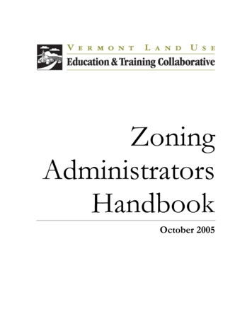
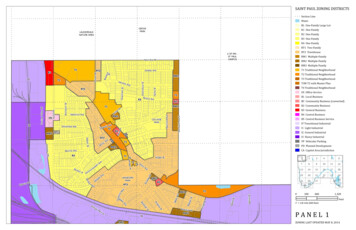
Hazel StTower StJayne StHo ward St NT2 Traditional NeighborhoodT3 Traditional NeighborhoodB3T3M T3 with Master PlanT4 Traditional NeighborhoodOS Office-ServicePedersen StSunrayB1 Local BusinessBC Community Business (converted)B2 Community BusinessRM2B3 General BusinessB4 Central BusinessB5 Central Business ServiceIT Transitional IndustrialI1 Light IndustrialRM3I2 General IndustrialParkside DrI3 Heavy IndustrialVP Vehicular ParkingPD Planned DevelopmentDrCA Capitol Area JurisdictionBerland PlMcknight Rd SKipling StMorningside DrB StdSL ongfellow AveNelson StMitchell AveMichael StHorryWinthrop St SHilding AveCutler StWarren StSandralee Dr ERdRuth St SsRg laouRdT1 Traditional NeighborhoodOSPow ers Av eBattle Creek RdtDHatcheI2 ryWhite Bear Ave SinPoFishCStRM3 Multiple-FamilyB2La1BATTLECREEKPONDRM2 Multiple-FamilyNorth Pa rk Dr6wayA StRM1 Multiple-FamilyPath ways D rFoxridge RdhHigR1perAftonRT2 TownhouseB2RT1RT2PlUpGrace LnValleyside DrLuella St SektWarbler LnDarlene StPlRT1 Two-FamilyRdBurns AveRM3Faye StFlandrau PlLyon StRo weWoodcrest DrBattle C r eUpper Afton TerR2R3 One-FamilyRT1Ruth St NWhite Bear Ave NlKim PLouise AveServiceWinthrop St NRT2LnR2 One-FamilyScenic PlParkland CR1 One-FamilyHudsonRdT2RM1RL One-Family Large LotMcknight Rd NSuburban AveWaterR4 One-FamilyR3Sandralee Dr WHazelwoo d StB2Section LineRM2RM2B2B3Leone AveDoraB3
U OF MN - ST PAUL CAMPUS GROVE LAUDERDALE PARK NATURE AREA COLLEGE PARK LANGFORD PARK Valentine Ave E n e r g y P a r k D r C o m o A v e e e N G o r d o n A v e e t W e Bl a k e A v e e e t C o m m o n w e a l t h A v e G o v e P l K n a p p P l t Dudley Ave Buford Ave . SAINT PAUL ZONING DISTRICTS ZONING LAST UPDATED MAY 8, 2014 P A N E L 1 .