Transcription
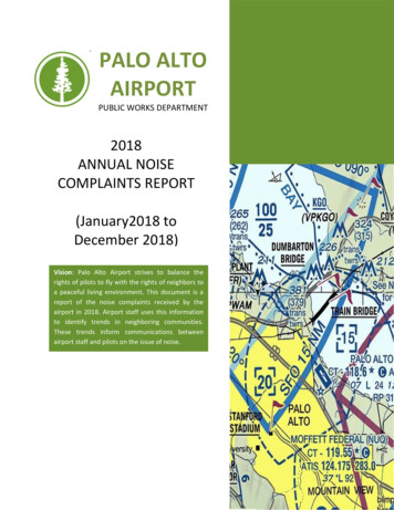
PALO ALTOAIRPORTPUBLIC WORKS DEPARTMENT2018ANNUAL NOISECOMPLAINTS REPORT(January2018 toDecember 2018)AUG 2014 – SEPT 2015(Q4 2014 – Q3 2015)*Vision: Palo Alto Airport strives to balance therights of pilots to fly with the rights of neighbors toa peaceful living environment. This document is areport of the noise complaints received by theairport in 2018. Airport staff uses this informationto identify trends in neighboring communities.These trends inform communications betweenairport staff and pilots on the issue of noise.
Introduction:The following is a report of noise complaints received by Palo Alto Airport (PAO) in 2018. The FederalAviation Administration (FAA) defines air travel routes and procedures, including defining separationdistances between aircraft, determining hazards to aviation and all other safety criteria for aircraft, andis responsible for directing and enforcing the movement of aircraft in flight. Although organizations canpetition the FAA regarding flight procedures, the FAA has the final say in what is safe and acceptable.The Airport Noise and Capacity Act (ANCA) of 1990 federally prohibits public-use airports fromrestricting airspace in any way.The FAA measures noise based on the Yearly Day and Night Average Sound Level (DNL) and theCommunity Noise Equivalent Level (CNEL). While both are essentially the same, airports in California usethe CNEL method to measure noise. CNEL is a method of averaging single event aircraft noise into aweighted 24-hour average. The system adds penalties to all events occurring during the evening (7pm –10pm) and the night (10pm – 7am). The Santa Clara County Airport Land Use Commission (SCC ALUC)performed a noise study for the Palo Alto Airport using the CNEL to determine the noise contours for 55,60, 65, and 70 decibels. The contour map is included as Attachment A.Regarding safety and altitude, the FAA has in place Federal Aviation Regulations (FARs) that establishesMinimum Safe Altitudes (MSAs) for aircraft. For fixed wing aircraft, the minimum is 1000 feet aboveground when over congested areas and 500 feet when not over congested areas. These minimumaltitudes apply to all fixed wing aircraft except when necessary for landing and takeoff operations.Helicopters are exempt from these altitude restrictions due to the nature of their flight. These minimumaltitudes are enforced by the FAA Flight Standards District Office in San Jose, not by the Palo AltoAirport. Palo Alto Airport cannot tell pilots when or where to fly; the airport, however, does havevoluntary noise abatement procedures that Palo Alto Airport recommends that pilots follow. (See theNoise Abatement Procedures section below.)The airport receives noise complaints via email at pao@cityofpaloalto.org and a noise complaint hotline650-329-2405. Airport staff review and timely respond to all complaints, ascertaining as muchinformation from complainants, including contact information, date, time and description of theoccurrence. Various flight trackers can be used in an attempt to help identify the aircraft involved andverify if FAA regulations or Palo Alto Airport procedures were violated. The airport staff reviews andcompiles all data to determine trends with flying activities.Purpose:The purpose of the Palo Alto Airport AnnualNoise Report is to identify noise trends in thesurrounding areas and determine compliancewith established voluntary noise abatementprocedures.Airspace:The Palo Alto Airport airspace is unique. Thecongested Bay Area airspace is dominated bySFO Class Bravo airspace, which encompasses aPalo Alto Airport Sectional MapPalo Alto Airport in GreenPAO Airspace highlighted in RedSource: http://vfrmap.com/?type vfrc&lat 37.461&lon -122.115&zoom 10
30 nautical mile radius around SFO. Underneath the Class Bravo airspace lays the Class Charlie airspaceof Oakland and San Jose international airports. Finally, Moffett Airfield lies approximately 4 nauticalmiles to the southeast of Palo Alto Airport.As a result, Palo Alto Airport airspace ends only 1.5 nautical miles southeast of Runway 31’s finalapproachthe Palo Alto Airport’s single runway (Runway 13/31). To land at Palo Alto Airport, aircraftmust turn before entering Moffett’s airspace, resulting in aircraft having to space themselves in trafficpatterns over the peninsula when take-off/landing volumes peak. The FAA’s Air Traffic Control Tower(ATCT) at Palo Alto Airport has a letter of agreement with Moffett’s ATCT providing Palo Alto Airportaircraft with extensions into Moffett airspace when Moffett airfield is not in use. The additional airspaceis a useful mitigation tool during busy times.Further restrictions in Palo Alto Airport airspace come from San Jose Class C airspace, starting at 1500feet Mean Sea Level, just southeast of Palo Alto Airport and SFO Class B airspace, starting at 2500 feetMean Sea Level, just northeast of the Palo Alto Airport. Both are identified on the Palo Alto AirportSectional Map: San Jose Class C is shown with thick magenta lines and SFO Class B is shown with thickblue lines. These restrictions play a vital role in aircraft departures, in turn influencing noise abatementprocedures for the Palo Alto Airport.Noise Abatement Procedures:Noise abatement procedures are voluntary procedures that the airport asks pilots to follow. The airportis prohibited from restricting airspace. Palo Alto Airport staff will speak with individual pilots andeducate them about the voluntary noise abatement procedures. The Palo Alto Airport cannot levy fineson pilots that violate the voluntary noise procedures. For illustrated noise abatement proceduresreference Palo Alto Airport Pilots Handout included as Attachment B.The noise abatement procedures depend on the runway that is in use at the time. Depending onweather patterns, aircraft can depart on Runway 31 to the northeast or Runway 13 to the south east.Approximately 90% of the time, weather conditions require the use of Runway 31. Pilots are asked tonot make a left crosswing departure from Runway 31, but instead make a “Left Dumbartion Departure”(fly to the Dumbarton Auto Bridge before making a left turn and flying over East Palo Alto) or a right 270degree turn before departing to the south or west. When aircraft are using Runway 13, pilots are askedto make a left 270 degree turn. In addition to these procedures, pilots are asked to climb to 1500 feet orabove ground before crossing Highway 101 and reduce power when safely able.Pilots are asked to fly over the bay whenever possible. If pilots must fly over the peninsula, they areasked to reduce power and fly at or above 1500 feet above ground before crossing Highway 101. Staffalso asks that aircraft not make a left crosswind departure, but instead make a “Left DumbartonDeparture” (fly to the Dumbarton Auto Bridge before making a left turn and flying over East Palo Alto) ora right 270 degree turn whenever departing to the south or west from Runway 31. When aircraft areusing Runway 13, pilots are asked to make a left 270 departure before flying west over Palo Alto.For arrivals, it is standard practice and necessary for pilots to descend to pattern altitude beforeentering the traffic pattern around PAO, sometimes requiring aircraft to descend below the 1500 feetminimum over Palo Alto. As these aircraft are descending to land the engines are generally poweredback and quieter than ascending aircraft.
Airport staff continuously engages with tenants and pilots about the voluntary noise abatementprocedures, always noting that safety always supersedes noise.Findings:The Palo Alto Airport remains one of the busiest general aviation airports in the bay area with anaverage of 163,360 operations per year since 2009, significantly less than the average of 195,800operations per year between 1999 and 2008 (Table 1). An operation is defined as either a takeoff or alanding and a touch-and-go procedure will account for two operations.Table 1. Airport OperationsAir TaxiMilitaryTotalAir age135782163360During the 2018 Calendar year, the Airport logged 110 total noise complaints from 32 households. Table2 shows the number of complaints by quarter, and includes the totals from 2017.Table 2. Complaints ReceivedQuarter 1 Quarter 2 Quarter 3 Quarter 4 Total 2018 Total ble 3 sorts the complaints logged into three sections. The first one is PAO which includes allcomplaints that involve aircraft that performed an operation at the airport. The next section is Generalwhich includes complaints that did not include a specific aircraft or incident of noise. These complaintsmay or may not involve aircraft from PAO. The last section is Non-PAO, which include aircraft that arenot based or did not operate at the airport. These flights could include CHP, Coast Guard, Air Taxis,Survey and or banner towing operations. Also included in Table 3 are the totals for 2017.
PAOGeneralNon-PAOTable 3. Aircraft AssociationQuarter 1 Quarter 2 Quarter 3 Quarter 4 Total 2018 Total 20176871510100103300202142042851Table 4 below provides a detailed breakdown of the 110 PAO related complaints by city. Mostcomplaints came from Sunnyvale, with 62 complaints logged from 3 households. Palo Alto was thesecond most impacted city, with 26 complaints from 12 households.Table 4. PAO Noise Complaints by CityQuarter 1Quarter 2Quarter 3Quarter 4Total 2018Total 2017CityCHCHCHCHCHCHAtherton11Cupertino11East Palo Alto11112272Fremont111131Hayward11Los Altos1151117231Menlo Park112233122Millbrae11Mountain View111111Palo Alto3241971052611314Portola Valley114455San Carlos111143San Rafeal11Scotts Valley1111Sunnyvale62362398321Unknown11West San Jose11Woodside111122Total701074211512711032 1033 44Table 5 below shows the general type of aircraft identified as causing noise complaints at the airport.There are 2 types of engines for aircraft utilizing PAO. The first is reciprocating which is similar to anautomobile engine, and the second is turboprop which is a turbine engine with a propeller thatproduces thrust. Aircraft are further differentiated by “multi” and “single” which denotes the number ofengines for the aircraft. In the case of PAO all multi engine aircraft have 2 engines. As Table 5, showssingle reciprocating aircraft produced the largest portion of noise complaints. This class of aircraftrepresents most of the fleet at PAO and usually consists of Cessna, Pipers and Cirrus aircraft. There were2 complaints where staff was unable to identify the type of aircraft involved in the flight.
Table 5. Aircraft TypeHelicopter2018 Complaints2017 ComplaintsMultiMultiSingleSingleReciprocating TurbopropReciprocating TurbopropUnknown282815219495377611323Table 6 below shows the number of violations of the established noise abatement procedures. Airportstaff makes every effort to talk to all pilots that violate these procedures, but it is difficult to talk to alltransient pilots about noise abatement procedures. It is not the role of the FAA Air Traffic Control Towerto advise pilots of the noise abatement procedures, but the City has develop a working relationship withthe ATCT and Air Controllers do advise pilots of the noise abatement procedures when they have theability.Table 6. Observed Violations of Noise Abatement ProceduresQuarter 1 Quarter 2 Quarter 3 Quarter 3774146181% Compliance99.9%99.9%100%99.9%99.9%
Attachment APAO Noise Contour MapFollowing is a noise contour map for PAO, adopted by the Santa Clara County Airport Land UseCommission (SCC ALUC) in their 2008 Comprehensive Land Use Plan, reflecting the forecasted noisecontours for Palo Alto Airport in 2022.SCC ALUC used the Integrated Noise Model which considers airport altitude, mean temperature, runwayconfiguration, aircraft flight track definition, aircraft departure and approach profiles, aircraft trafficvolume and fleet mix, and flight track utilization by aircraft types. All data is entered into the CNELformula to prepare the noise contours for Palo Alto Airport.Refer to ts/ALUC 20081119 PAO CLUP.pdf,for a more detailed description of how the SCC ALUC prepared this map.The 65 decibel (db) noise level of the airport extends beyond the airport boundaries, but is only overPalo Alto Golf Course, Palo Alto Baylands Nature Preserve, and the salt marshes in San Mateo County.and is the threshold at which FAA requires noise mitigation programs.Refer to ts/ALUC 20081119 PAO CLUP.pdf,for a more detailed description of how the SCC ALUC prepared this map.
2022 Forecasted Palo Alto Airport Noise Contour Map
Attachment BPAO Pilot HandoutSanta Clara County created a Pilot Handout for Palo Alto Airport that described the noise abatementprocedures. When the City of Palo Alto assumed control of the airport, the existing noise abatementprocedures were adopted, with one exception, “pilots must maintain 1500 feet or above across Highway101” was replaced with “Aircraft are asked to climb to and maintain at least 1500 feet before crossingHighway 101.” The change is consistent with the voluntary nature of noise abatement procedures asairports are federally prohibited from instructing pilots how to fly.
BE A GOOD NEIGHBOR – FLY SAFELY AND QUEITLYSafety FirstPalo Alto Airport General InformationBayside Pattern Alt - 800 feetPeninsula Side Pattern Alt – 1000 feet MSLATCT hours of operation – 0700 – 2100 hrsATC / CTA Frequency – 118.600ATC Ground Frequency – 125.000Fuel Frequencies – 122.85 or 122.95Airport Office Phone # – (650) 329-2444Peninsula SidePattern – 1000ftKeyPatternNoise Abatement DeparturesRWY 31Left270RWY 13Right270320 LeftDumbartonDeparturePalo Alto Airport asks foryour cooperation in reducingthe noise impact of aircrafton the neighboringcommunities.CAUTIONBayside Pattern – 800ftNot to be usedfor navigationNoise Abatement ProceduresPlease fly neighborly and be aware of the surroundingcommunities. There are noise sensitive areas to the westand south of the Airport. Aircraft are asked to climb andmaintain at least 1500 feet before crossing Highway 101.Fly over the bay whenever possible.Please use reduced power setting whenever possible toreduce noise impacts. Even a reduction in a 200 RPM cansignificantly reduce noise.Safety Always Supersedes Noise AbatementBe Aware Palo AltoAirport Lies under SFOClass B AirspaceThe Palo Alto Baylands preserveis located immediately to thenorth of the airport. Watch forbirds on or near the airport.Be alert for bikes & pedestrianscrossing a levee road 290’ fromdeparture end to Runway 31.Preferred West Bound DeparturesRunway 31Left Dumbarton DepartureWhen departing runway 31 turn right 10 on takeoff and climb over the bay. Fly straight toDumbarton Auto Bridge before making a left turn to fly over the peninsula or to the south.Cross Highway 101 at or above 1500 feet.Left 270 DepartureAfter takeoff climb over the bay while making a 270 turn and heading west or south over thepeninsula. Cross Highway 101 at or above 1500 feet.Runway 13Right 270 DepartureAfter takeoff turn right over and climb over the bay while making a 270 turn and heading westor south over peninsula. Cross Highway 101 at or above 1500 feet.
Attachment CMap of Palo Alto Households1121112121Note: There were 2 callers that didnot provide addresses. Each callerlogged 1 complaint with Airport Staff.This map shows the approximate location and number of complaints from households within Palo Alto. This map wasgenerated using GISt by airport staff.
PALO ALTO AIRPORT PUBLIC WORKS DEPARTMENT 2018 ANNUAL NOISE COMPLAINTS REPORT (January2018 to December 2018) AUG 2014 - SEPT 2015 (Q4 2014 - Q3 2015)* Vision: Palo Alto Airport strives to balance the rights of pilots to fly with the rights of neighbors to a peaceful living environment. .