Transcription
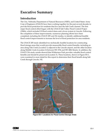
Executive SummaryIntroductionThe City, Nebraska Department of Natural Resources (NRD), and United States ArmyCorp of Engineers (USACE) have been working together for the past several decades toprovide flood protection for residents that live near the Salt Creek channel. The firstmajor flood control effort began with the USACE Salt Valley Flood Control Project(1960s), which included 10 flood control dams and a levee system in Lincoln. Followingthe completion of these improvements, numerous planning efforts have beencompleted, including the USACE 205 and 216 studies, to identify additional feasibleflood control improvements to increase the level of flood protection for area residents.The USACE 205 study identified two technically feasible locations for constructingflood storage areas that would provide measurable flood control benefits, including anarea along Oak Creek (Location 1) adjacent to the Lincoln airport, and the other locationalong Middle Creek (Location 2) between SW 27th and SW 40th Streets. In addition, theUSACE 216 study results showed that Wilderness Park provides valuable flood controlbenefits and should be preserved (Location 3). These locations, shown in Figure ES-1,were examined in more detail for this report to determine their flood benefit along SaltCreek through Lincoln, NE.Figure ES-1 Locations for Flood Control Storage AreasES-1P:\22036 (Lincoln, NE)\64022 (Storage Areas)\7.0 Technical\7.06 Reports\7.06.01 Revised Report\Report\Executive Summary final.doc
Executive SummaryWith the recent completion of the Salt Creek DFIRM Update project, a state-of-thepractice hydrologic and hydraulic computer model is now available to further evaluatethe feasibility of constructing additional flood control projects. The updated FEMADFIRM identified over 5,600 habitable buildings within the Salt Creek floodplainbetween Saltillo Road and 98th Street. Therefore, the purpose of this project is tosimulate the two storage area facilities as previously identified by USACE, andlocations near Wilderness Park, using the latest computer model to better quantify theflood control benefits of these potential facilities. In addition, the functionality of eachstorage facility will be further evaluated based on the existing site characteristics, multiuse features, construction constraints, and input received during the publicparticipation process.Wilderness ParkWilderness Park is characterized by dense wooded area with few large opens spaces. Itis owned by Lancaster County, and encompasses all of Salt Creek from Saltillo Road toVan Dorn Street, where the Creek enters City boundaries.Existing Overbank Flood StorageWilderness Park along Salt Creek has preserved approximately 1,400 acres ofundeveloped space that serves as overbank flood storage. During large rainfall eventswhen Salt Creek exceed its banks this open space is temporarily flooded. Figure ES-2 isa photograph taken near S 14th Street and Yankee Hill Road which shows overbankflow in Wilderness Park. This was the result of a flood event on June 5, 2008.Figure ES-2 Wilderness Park Overbank Flood StorageES-2P:\22036 (Lincoln, NE)\64022 (Storage Areas)\7.0 Technical\7.06 Reports\7.06.01 Revised Report\Report\Executive Summary final.doc
Executive SummaryThis existing overbank flood storage within Wilderness Park has a flood benefitdownstream. Using the available unsteady HEC-RAS model of Salt Creek the projectteam simulated two hypothetical conditions within Wilderness Park (Figure ES-3):1) Loss of overbank flood storage up to the mapped FEMA floodway; and2) Loss of overbank flood storage to width no greater than 300-feet.This second more extreme encroachment case was an approximate representation of thetypical encroached of Salt Creek downstream from Wilderness Park.Figure ES-3 Wilderness Park Evaluation ScenariosThe analysis clearly showed that the existing overbank storage within WildernessPark provides a reduction in flow and water surface elevations in the Park anddownstream to the confluence with Haines Branch, with a diminished reductiondownstream. As shown in Tables ES-1 and ES-2, peak flow attenuation is also seenimmediately downstream of Beal Slough to the confluence with Middle Creek.Overall, this analysis shows that flood attenuation provided by Wilderness ParkES-3P:\22036 (Lincoln, NE)\64022 (Storage Areas)\7.0 Technical\7.06 Reports\7.06.01 Revised Report\Report\Executive Summary final.doc
Executive Summaryreduces flooding in heavily urban areas of Lincoln, NE, along Salt Creek, especiallydownstream of the Park and upstream of Middle Creek (South Bottoms vicinity).Table ES-1 Wilderness Park Analysis –Maximum Water Surface ComparisonLocation DescriptionUS of Saltillo RdDS of 14th StDS of Cardwell BranchUS of Old CheneyDS of Beal SloughDS of Haines BranchDS of Middle CreekUS of Railroad BridgeSalt CreekDFIRMMaximumWaterSurfaceElevation (ft)1,1991,1841,1751,1661,1591,1561,1531,152Salt Creek Storage Area AnalysisScenario 1Scenario ebetweenSurfaceElevationScenario 1Elevation(ft)& DFIRM ,1520.01,152DS of Oak Creek1,139Shaded locations are within Wilderness o 2 &DFIRM (ft)5.86.83.25.51.90.20.30.30.2Table ES-2 Wilderness Park Analysis –Peak Flow ComparisonSalt Creek Storage Area AnalysisDifferenceScenario 1betweenScenario 2Peak FlowScenario 1Peak Flow(cfs)& DFIRM(cfs)DifferencebetweenScenario 2 &DFIRMLocation DescriptionSalt CreekDFIRM PeakFlow (cfs)US of Saltillo Rd14,40114,321-0.6%14,394DS of 14th St14,48614,350-0.9%14,5550.5%DS of Cardwell Branch14,72314,637-0.6%14,645-0.5%-0.1%US of Old Cheney14,69714,623-0.5%14,689-0.1%DS of Beal Slough14,88015,5714.6%17,49117.5%DS of Haines Branch21,03121,0250.0%23,57612.1%DS of Middle Creek28,00528,0280.1%27,767-0.8%US of Railroad 3%DS of Oak Creek40,410Shaded locations are within Wilderness ParkAdditional Offline DetentionWithin the Wilderness Park Area several options were considered for locations ofadditional offline storage. However, there were limited opportunities for additional floodstorage without significantly impacting the mature riparian vegetation. In addition,existing linear transportation infrastructure that bound the area on the west and eastlimit the area for additional offline flood detention. One area of existing open spacelocated to the west of Yankee Hill Road and South 14th Street, shown in Figure ES-4, wasdetermined to be the best available option for additional offline detention. An evaluationof this offline detention location resulted in no additional flood benefit downstream. Theprimary reason for the lack of flood benefit at this location is the large drainage area tothis point and the double runoff peak of Salt Creek. As shown in Figure ES-5, Salt CreekES-4P:\22036 (Lincoln, NE)\64022 (Storage Areas)\7.0 Technical\7.06 Reports\7.06.01 Revised Report\Report\Executive Summary final.doc
Executive Summaryhas a double peak runoff response which significantly limits the flood benefit of offlinedetention because the offline detention is filled by the first peak leaving no flood storagefor the larger second peak. Therefore no further evaluation of additional offline detentionwas completed for this study.Figure ES-4 Wilderness Park Offline Storage SiteFigure ES-5 100-Year Runoff Flow and WSEES-5P:\22036 (Lincoln, NE)\64022 (Storage Areas)\7.0 Technical\7.06 Reports\7.06.01 Revised Report\Report\Executive Summary final.doc
Executive SummaryStorage Area EvaluationOffline storage sites were evaluated in detail at only two of the three proposed locationsbecause the Wilderness Park site was eliminated during the preliminary evaluation. Asshown in Figure ES-6, three offline detention sites were evaluated for the two remaininglocations. The three offline storage sites that were evaluated in detail for this studywere: Middle Creek Site - South of A Street, between SW 27th and SW 40th Streets Oak Creek Upstream Site - Near the airport located west of the airport runway andsouth of Lincoln Air Park West; and Oak Creek Downstream Site - Located south of the Air National Guard base and northof Oak Creek.Figure ES-6 Offline Storage Sites EvaluatedMiddle Creek SiteThe Middle Creek site generally bounded by Southwest 40th Street to the west,Southwest 27th Street to the east, West “A” Street to the south, and Middle Creek to thenorth, is characterized by open space which is currently agricultural fields . As shownin Figure ES-7, the conceptual offline storage area design is two large storage basins thatare hydraulically connected which provided maximum flood storage at this site. Thisdesign allowed for expanded storage along Middle Creek with an East Middle Creekand West Middle Creek storage basin. Several options for conveying flow into, out,and between the basins were considered. The resulting design uses concrete culvertswith flap gates to control flow into and out of the basins and concrete culverts toconnect the various cells. An unsteady HEC-RAS model was used to simulate thisES-6P:\22036 (Lincoln, NE)\64022 (Storage Areas)\7.0 Technical\7.06 Reports\7.06.01 Revised Report\Report\Executive Summary final.doc
Executive SummaryMiddle Creek offline storage design which simulated the filling and dewatering of thebasins.Figure ES-7 Middle Creek Offline StorageThe westernmost basin has a maximum storage of 222.9 acre-feet at water surfaceelevation of 1,164 feet, and the eastern most basin has a maximum storage of 334.1acre-feet at a water surface elevation of 1,164 feet. The conceptual design allows forthe possibility of the inclusion of five multi-use fields to utilize the site area duringdry conditions.Excavation will be extensive with an estimated 680,000 cubic yards of excess material.As proposed, the excess material will be disposed on the adjoining site to the south andsoutheast. Disposing the excess fill material on site was the most cost effectivealternative. The estimated cost of these storage basins along Middle Creek was 15.4million.Oak Creek Upstream SiteThe Oak Creek upstream site is generally bounded by Oak Creek to the north, LincolnAirport to the east, and Northwest 41st Street to the west. It is characterized by openspace which is currently used as agriculture, as shown in Figure ES-8.The Oak Creek upstream storage basin conceptual design followed a similar processto that of Middle Creek to increase the volume of storage; two hydraulicallyconnected basins were designed as well as a third, separate basin. This allowedES-7P:\22036 (Lincoln, NE)\64022 (Storage Areas)\7.0 Technical\7.06 Reports\7.06.01 Revised Report\Report\Executive Summary final.doc
Executive Summarystorage to expand along Oak Creek, producing a Northwest (NW) upstream OakCreek storage basin, a Northeast (NE) upstream Oak Creek storage basin, and a South(S) upstream Oak Creek storage basin (Figure ES-8). Several options for conveyingflow between the basins were considered, and concrete culverts were found to be themost cost-effective solution. An unsteady HEC-RAS model was used to simulate thisoffline storage design which simulated the filling and dewatering of the basins.Figure ES-8. Oak Creek Upstream Offline StorageThe conceptual-level design included two northernmost basins (NW and NE basins)which are hydraulically connected as well as an independent southern basin. The NWbasin has a maximum storage of 545.0 acre-feet at a water surface elevation of 1,164feet, the NE basin has a maximum storage of 343.3 acre-feet at water surface elevationof 1,164 feet, and the S basin has a maximum storage of 288.8 acre-ft at a water surfaceelevation of 1,164 feet. The conceptual design provides a total of 1,177.1 acre-feet ofoffline flood storage. In addition, the design allows for the possibility of the inclusionof a multi-use field to utilize the site under normal, dry conditions. Flow enters andexits the basins through concrete culverts with tensioned flap gates, which are used tocontrol the timing and amount of flow allowed into and out of the basins.As with the Middle Creek sites the excavation will be extensive with an estimated950,000 cubic yards of excess material. As proposed, the excess material will bedisposed on open areas owned by the Lincoln Airport within 1-mile of the site. Theestimated cost of these storage basins at the upstream Oak Creek site was 18.2million.ES-8P:\22036 (Lincoln, NE)\64022 (Storage Areas)\7.0 Technical\7.06 Reports\7.06.01 Revised Report\Report\Executive Summary final.doc
Executive SummaryOak Creek Downstream SiteThe Oak Creek downstream site was identified during the site evaluation process, andis generally bounded by Oak Creek to the south, Air National Base to the north andLincoln Airport to the west. It is characterized as an open grassed area as shown inFigure ES-9.Figure ES-9 Oak Creek Downstream Offline StorageThis storage area was also divided into two cells, east and west. These offline storagesites are relatively small compared to the upstream site. The design included twobasins (W and E basins) which are hydraulically connected. The W basin has amaximum storage of 95.4 acre-feet at a water surface elevation of 1,154 feet; the Ebasin has a maximum storage of 127.7 acre-feet at a water surface elevation of 1,154feet. The conceptual design provides a total of 223.1 acre-feet of offline flood storage.Flow enters and exits the basins through concrete culverts with tensioned flap gates,which are used to control the timing and amount of flow allowed into and out of thebasins.The estimated excavation is 240,000 cubic yards of excess material. As proposed, theexcess material will be disposed on open areas owned by the Lincoln Airport within 1mile of the site. The estimated cost of these storage basins at the downstream Oak Creeksite was 5.0 million.ES-9P:\22036 (Lincoln, NE)\64022 (Storage Areas)\7.0 Technical\7.06 Reports\7.06.01 Revised Report\Report\Executive Summary final.doc
Executive SummarySummary of CostThese seven storage basins at three sites were the preferred storage alternative thatprovided the most flood benefit downstream along Salt Creek. Table ES-3 provides asummary of the seven basins including the estimated cost.Table ES-3 Summary of Seven Basins by LocationSite Location (No. d StorageCostMiddle Creek (2)83 ac680,000 CY557 ac-ft 15,400,000Oak Creek – Upstream (3)124 ac950,000 CY1,177 ac-ft 18,200,000Oak Creek – Downstream (2)41ac240,000 CY223 ac-ft 5,000,000Total (7)248 ac1,870,000 CY1,957 ac-ft 38,600,000Summary of Flood BenefitThe combination of all seven basins at the Oak Creek Upstream, Oak CreekDownstream, and Middle Creek sites represents the most beneficial offline storagedesign, taking into account the combined effect of the basins, site specific issues,constructability, cost, and maintenance. The average and maximum flood benefitdownstream along Salt Creek through Lincoln for the 100-year event is shown in TableES-4. Figure ES-10 provides a map of the flood benefits along Salt Creek.Table ES-4 Preferred Alternative Flood Depth 3MC050.020.02Approximate LimitsSaltillo Road to Confluence with Cardwell BranchConfluence with Cardwell Branch to Confluence withHaines BranchConfluence with Haines Branch to Confluence withMiddle CreekConfluence with Middle Creek to Confluence withOak CreekConfluence with Oak Creek to Confluence with LittleSalt CreekConfluence with Little Salt Creek to North 98th StreetConfluence with Little Salt Creek to North 112thStreetThe preferred alternative would take approximately 31 structures out of the 100-yearfloodplain, and typically reduces the 100-year flooding depths by 0.1 feet at structures.For the 50-year event, the preferred alternative takes approximately 51 structures out ofthe floodplain and typically reduces flooding depths by 0.3 feet, and for the 10-yearevent, it takes approximately 64 structures out of the floodplain and typically reducesflooding depths by 0.4 feet.ES-10P:\22036 (Lincoln, NE)\64022 (Storage Areas)\7.0 Technical\7.06 Reports\7.06.01 Revised Report\Report\Executive Summary final.doc
Executive SummaryFigure ES-10 Preferred Alternative 100-Year Flood Depth Reduction throughLincoln, NebraskaES-11P:\22036 (Lincoln, NE)\64022 (Storage Areas)\7.0 Technical\7.06 Reports\7.06.01 Revised Report\Report\Executive Summary final.doc
Executive SummaryBenefit-Cost AnalysisDue to the magnitude of the preferred storage alternative, which encompasses all seven(7) basins, a benefit-cost analysis (BCA) was conducted to evaluate the economicfeasibility of implementation. The economic evaluation was conducted using a benefitcost ratio (BCR) approach based on FEMA procedures.The FEMA BCR procedure consists of determining whether the cost of the mitigationproject today will result in sufficient flood damage reduction in the future to justify thecapital investment of the project. If the benefit is determined to be greater than theestimated project cost, then the project is considered justified. However, if the benefit isless than the project cost, then the project is not considered cost-effective. Thus, theBCR, which is calculated by dividing the benefits by the costs, should have a value of1.0 or greater.Estimated BenefitsThe estimated flood damages before the projects (existing conditions) and after theprojects are summarized in Tables ES-5 and ES-6, respectively. The total damages fromthe 100-year event include damages to the airport estimated in the Oak Creek LeveeStudy, completed by HWS Consulting Group, Inc.Table ES-5 Total Physical Damages Before Preferred AlternativeFlood FrequencyEvents (Years)1050100Total DamagesContentsStreetsand Losses 7,000,000 400,000 26,400,000 39,000,000 4,000,000 140,000,000 64,000,000 7,000,000 240,600,000*Total Annualized Damages 7,180,000*The 100-year total damages includes damages to the airport estimated in the Oak Creek Levee Study,completed by HWS Consulting Group, IncBuildings 19,000,000 94,000,000 166,000,000Table ES-6 Total Physical Damages After Preferred AlternativeFlood FrequencyEvents (Years)1050100Buildings 16,000,000 88,000,000 149,000,000ContentsStreets 5,000,000 300,000 33,000,000 3,000,000 60,000,000 7,000,000Total Annualized DamagesTotal Damagesand Losses 21,300,000 124,000,000 216,000,000 6,250,000The benefit is defined as the avoided physical damages after project compared to that ofexisting conditions. Subtracting the total annualized damages of existing conditionsfrom the total annualized damages after implementing the preferred alternative, thetotal annual benefit equals approximately 0.93 million. Before calculating BCR, theexpected annual benefit must be converted to present value dollars. Using the currentWater Resources Institute discount rate of 4 7/8 percent and a project life of 50 years, thepresent value of 0.93 million equals 17.3 million.The estimated cost for the preferred storage basin alternatives was approximately 38.6million plus 0.56 million operation and maintenance for a total project cost of 39.2million. In summary, a BCR value of 1.0 or above is desirable to justify the economicfeasibility of constructing large-scale improvement projects. For this Study aES-12P:\22036 (Lincoln, NE)\64022 (Storage Areas)\7.0 Technical\7.06 Reports\7.06.01 Revised Report\Report\Executive Summary final.doc
Executive Summarypreliminary BCR value of 0.44 was estimated based solely on physical damages.Typically, if the BCR ratio is above 0.75 when only assuming physical damages, thenthe BCR will exceed 1.0 when the other three categories (loss of function, emergencymanagement, and casualties) are factored into the calculations. Therefore, at thisconceptual stage of the project formulation process, the preferred alternative does notappear to be economically viable.However, the proposed storage basins along Oak Creek may be a viable project whenconsidering the local flood benefits along Oak Creek and the desire by the airport toupdate the existing levees to FEMA standards. A more detailed analysis of thiscombined benefit would need to be evaluated which was beyond the scope of thisstudy.ES-13P:\22036 (Lincoln, NE)\64022 (Storage Areas)\7.0 Technical\7.06 Reports\7.06.01 Revised Report\Report\Executive Summary final.doc
Van Dorn Street, where the Creek enters City boundaries. Existing Overbank Flood Storage Wilderness Park along Salt Creek has preserved approximately 1,400 acres of undeveloped space that serves as overbank flood storage. During large rainfall events when Salt Creek exceed its banks this open space is temporarily flooded. Figure ES-2 is