Transcription
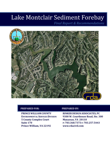
Lake Montclair Sediment ForebayFinal Report & RecommendationsPREPARED FOR:PRINCE WILLIAM COUNTYENVIRONMENTAL SERVICES DIVISION5 County Complex CourtSuite 170Prince William, VA 22192PREPARED BY:RINKER DESIGN ASSOCIATES, PC9300 W. Courthouse Road, Ste. 300Manassas, VA 20110P: 703.368.7373 F: 703.257.5443www.rdacivil.com
TABLE OF CONTENTSIntroduction . 2Scope of Work & Methodology . 2Scope of Work . 2Methodology. 2Design Alternatives. 3Option 1 – In Lake Option. 3Option 2 – Parallel to Powell’s Creek Option. 4Option 3 – Parallel to Gas Easement Option . 4Option 4 – Wetland Option. 5Option 5 – Northern Side of Powell’s Creek Option. 5Option 6 – Forebay Created by Existing Sanitary Sewer Option. 6Option 7 – Source Control Option. 6Option 8 – “Hands Off” Option. 7Conclusions & Recommendations . 8Project Location Map.Appendix AOption 1 Preliminary Drawing.Appendix BOption 2 Preliminary Drawing. Appendix COption 3 Preliminary Drawing. Appendix DOption 4 Preliminary Drawing. Appendix EOption 5 North Shore Sediment Forebay Exhibit . Appendix FLake Montclair Option Benefit Matrix.Appendix GMiscellaneous Photographs . Appendix HLake Montclair Sediment Forebay ‐ Final Report and RecommendationsPWC Contract No. 9029NA2 / Task Order No. 4[Table of Contents]
INTRODUCTIONLake Montclair is an approximately 108‐acre body of water with an upstream drainage area ofapproximately eleven square miles. Located within the Montclair subdivision in Dumfries, Va.,Lake Montclair is bordered to the south by Dumfries Road (Route 234) and Waterway Drive, tothe north and east by Waterway Drive, and to the west by Southlake Boulevard. Lake Montclair isfed by the main channel of Powells Creek, which flows into the northernmost portion of the lake.Citizen concern in recent years regarding the amount of sediment entering the lake led PrinceWilliam County’s Environmental Services Division to begin exploring design alternatives to lessenthe sediment load and water quality in Lake Montclair. As a privately owned lake, themaintenance and sediment removal from Lake Montclair falls upon the Montclair PropertyOwners Association (MPOA). The MPOA turned to Prince William County (PWC) to investigateoptions to reduce the sediment deposition which would improve the overall water quality of thelake. Prince William County’s ultimate goal of this study is to determine the most feasiblemethods of reducing the sediment entering Lake Montclair and, thereby, improving the waterquality.SCOPE OF WORK AND METHODOLOGYSCOPE OF WORKPrince William County tasked Whitman, Requardt & Associates, LLP (WR&A) to create a feasibilitystudy regarding the potential sediment control measures for this Lake Montclair.WR&Aproduced a report entitled Lake Montclair Sedimentation Control Feasibility Study. This report,dated July 2008, presented three (3) possible design alternatives to address, and reduce, theamount of sediment deposited in Lake Montclair. RDA based the first three design alternativesevaluated with this report upon the findings from the WR&A study, which recommends,“ Construction of an In‐Lake Sediment Forebay to intercept a portion of the natural bed load andthe watershed generated sediment ” and the “ assessment and repair of sources of locallygenerated sediment.” Unfortunately, the South Lakes Cove (SLC) Homeowners Association hasexpressed stringent opposition to a paved maintenance access road through its property whichhas effectively ended any potential hope of constructing a forebay on the southern shore ofPowell’s Creek.Prince William County tasked Rinker Design Associates, P.C. (RDA) to review WR&A’s report andgenerate a basic design for the proposed forebays along with other potential alternatives whichwould also meet the County’s goal. RDA was requested to gather topographical survey data anddevelop design alternatives for a sediment forebay near the confluence of Powells Creek and LakeMontclair. The overall scope of work, as outlined in RDA’s proposal to PWC, included obtainingboundary and topographic survey information, collecting Prince William County GIS Data,evaluating possible design alternatives and locations for the proposed sediment forebay,providing materials to Prince William County for dissemination among the local residents andLake Montclair Sediment Forebay ‐ Final Report and RecommendationsPWC Contract No. 9029NA2 / Task Order No. 4[2]
community organizations, and the preparation of a final report and recommendations for feasibleoptions for the construction of a sediment forebay to benefit Lake Montclair. This report includesthe methodology that lead to the possible design alternatives, summaries of the designalternatives investigated, and recommendations for the most appropriate course of action toalleviate the sedimentation occurring within Lake Montclair.METHODOLOGYOn July 29, 2009, Ned Greene (a MPOA Board Member) led representatives from RDA and PWC ona boat tour of Lake Montclair to provide a first‐hand account of sediment issues facing LakeMontclair. RDA used this tour, as well as the information gained from listening to Mr. Greene, tobecome familiar with the sedimentation issues challenging the integrity of Lake Montclair.Drawing upon the knowledge gained from the boat tour with Mr. Greene and therecommendations included within the WR&A study, RDA performed a field‐run topographicsurvey from the confluence of Powells Creek and Lake Montclair to the west for approximately1,300 linear feet, until reaching the existing stormwater management pond and access roadlocated on the Forest Park High School site. RDA also collected and incorporated PWC GIS datainto the base drawing to supplement the field‐run survey efforts and provide a base map alongPowells Creek until reaching Spriggs Road. Utilizing the topographic information available, andusing the WR&A study as a basis for design, RDA developed numerous options for addressing LakeMontclair’s sedimentation issues. Summarized in detail in the following section, RDA developedthese design alternatives in an attempt to improve the overall water quality of Lake Montclair,while limiting the impacts to the surrounding residents and ecosystem.DESIGN ALTERNATIVESRDA developed design alternatives to lessen the sediment deposition occurring within LakeMontclair in Dumfries, Va. The following section provides a general description of each designalternative, as well as a discussion pertaining to the positive and negative aspects of eachalternative.OPTION 1 – IN‐LAKE OPTIONThe In‐Lake Option (Option 1) was the preferred solution proposed by the WR&A study. It wasthe determination of that report that this is the design that is the most effective in preventingsediment from entering Lake Montclair. Option 1 proposes the construction of a 2,370 cubic yard(total volume) sediment forebay at the confluence of Powells Creek and Lake Montclair. A flowdiverting structure would direct flow into the forebay prior to entering Lake Montclair. A pavedroad located along the bank of Powells Creek would allow for maintenance access and removal ofaccumulated sediment deposits. Additional advantages of this design option include the proposedvolumes for both the sediment loading and the total volume exceed the required valuesdetermined as part of the WR&A feasibility study, and that the Department of EnvironmentalQuality (DEQ) and Army Corps of Engineers (ACOE) reviewed and accepted the concept.Lake Montclair Sediment Forebay ‐ Final Report and RecommendationsPWC Contract No. 9029NA2 / Task Order No. 4[3]
There are a number of drawbacks to Option 1. Due to its location, this option requires the longestaccess road (approximately 1,871 linear feet). The access road requires an excessive amount ofgrading for construction, would have a significant longitudinal slope in places (10% ‐ 15%), andmust cross two drainage ways and an existing gas line, requiring culverts and utility protection.These factors result in an access road with significant construction costs, especially whencompared to the construction costs of the sediment forebay itself. Furthermore, this designalternative, will result in disturbance to approximately 0.40 acres of existing wetlands. While thenature of this disturbance will likely be relatively minor, mitigation measures will most likely berequired to offset impacts to the existing forested wetlands.The most significant drawback associated with Option 1 is the South Lakes Cove(SLC)Homeowners Association’s stringent opposition to a paved access road through its property. Thispaved road would provide the only point of access for maintenance operations to the sedimentforebay. At a meeting at RDA’s office on August 12, 2009, Mr. Guillermo Garcia, a representativefrom the South Lakes Cove HOA, stated that the HOA felt that unruly teenage activity wouldincrease if PWC constructed the paved access road within this area between the school and lake.Furthermore, Mr. Garcia expressed concerns regarding an increase in noise resulting fromdredging operations associated with the forebay. As a result, the SLC HOA denied access rightsacross their property and ultimately rejected Option 1.OPTION 2 – PARALLEL TO POWELLS CREEK OPTIONOption 2 proposes a sediment forebay along the southern side of Powells Creek. Sitedapproximately four hundred linear feet upstream of the confluence of Powells Creek and LakeMontclair, Option 2 results in an approximately 1,907 cubic yard facility parallel to Powells Creekand approximately 1,443 linear feet of paved roadway surface. The decreased length of the accessroad results in a lower associated construction cost and maintenance efforts when compared toOption 1. Additional advantages to Option 2 include fewer construction impacts to LakeMontclair, and reduced wetland disturbance when compared to Option 1 (0.26 acres of wetlandimpact associated with Option 2 versus 0.40 acres under Option 1).Despite these advantages, however, there are a number of negative aspects associated with Option2. First, due to its location, any sediment entering Powells Creek downstream of the Option 2facility will enter Lake Montclair. Additionally, due to the site constraints and existingtopographic features in the area, the total volume provided (1,907 cubic yards) is less than theWR&A required volume for the entire project of 2,300 cubic yards. Due to the site constraints andtopographical features for the entire project area, the proposed grading for the facility results in afacility that is smaller than the required volume. Similarly to Option 1, Option 2 includes theexcessive grading and longitudinal slopes associated with the access road, the fact that the accessroad will need to cross an existing gas line, and the likely mitigation measures associated with the0.26 acres of wetland disturbance previously mentioned and it would require disturbance of SLCHOA property.OPTION 3 – PARALLEL TO GAS EASEMENT OPTIONLake Montclair Sediment Forebay ‐ Final Report and RecommendationsPWC Contract No. 9029NA2 / Task Order No. 4[4]
Option 3 proposes an approximately 2,124 cubic yard sediment forebay at the confluence ofPowells Creek and an unnamed tributary flowing from the Forest Park High School stormwatermanagement pond and approximately 530 linear feet of paved roadway surface. Locatedapproximately 800 feet upstream of the confluence of Powells Creek and Lake Montclair, Option 3is adjacent to the existing Virginia Gas easement in the vicinity and parallel to Powells Creek.Based upon the findings in the WR&A study, the sediment volume provided through this designexceeds the assumed sediment loading from Powells Creek. This design also provides a sedimentforebay that will effectively control the sediment loading from the school’s outfall. Additionaladvantages to this design alternative include a relatively small amount of access road to construct(and maintain) and the elimination of any required gas line crossing. Finally, this option results inonly 0.04 acres of impact to the existing wetlands, which likely will not require mitigation.Despite these advantages, Option 3 contains fundamental flaws. First, due to the final elevationsrequired to construct the forebay and achieve the required volumes, Powells Creek will notactually flow into the forebay. The difference between the existing and proposed grades willresult in a forebay elevation higher than that of Powells Creek’s water surface elevation. Thiseliminates any effectiveness of the facility removing sediment from Powells Creek and, therefore,does not achieve the overall goal of the project. Additional disadvantages to this designalternative include those previously mentioned for Options 1 and 2: the access road will requiresignificant grading operations, while still having steep longitudinal slopes; the location’sconstraints (dimensions, existing grades, etc.) prevent the required storage volume from beingachieved through the design; there is a significant cost of constructing and maintaining the accessroad when compared to the overall cost of the forebay facility; and, as previously mentioned, theproject’s overall goal is not achievable as the final elevations preclude flow from Powells Creekfrom entering the forebay facility and it would require disturbance of SLC HOA property.OPTION 4 – WETLAND OPTIONOption 4 provides for sediment removal and improved water quality through constructedwetlands and approximately 760 linear feet of paved roadway surface. This design alternativeimproves the overall quality of the watershed in an environmentally friendly manner byemploying an innovative Best Management Practice (BMP). Design Option 4 allows for sedimentremoval, while limiting impact to the surrounding ecosystem. As an acceptable mitigation effort,the constructed wetlands will offset any impact to existing wetlands due to construction activities.Although Option 4 unobtrusively blends in with the surrounding ecosystem, its inherent designqualities make it difficult to quantify its sediment removing capacity. Therefore, it is difficult toascertain with any certainty the sediment loading controlled by the facility. This, in turn, makes itdifficult to predict its effectiveness in improving the water quality of Lake Montclair. Additionaldisadvantages associated with Option 4 include the excessive access road grading and longitudinalslopes (as discussed with other options as well), construction costs, maintenance costs inrestablishing existing and constructed wetlands, required utility crossings (one existing culvertand the existing gas line) and it would require disturbance of SLC HOA property.Lake Montclair Sediment Forebay ‐ Final Report and RecommendationsPWC Contract No. 9029NA2 / Task Order No. 4[5]
OPTION 5 – NORTHERN SIDE OF POWELLS CREEK OPTIONOption 5 proposes the construction of a sediment forebay along the northern side of PowellsCreek. While developed only qualitatively, this design option proposes an in‐stream forebayparallel to Powells Creek (similar in nature to Option 2). RDA developed this option as a responseto the lack of support from the South Lakes Cove HOA. Benefits associated with a sedimentforebay constructed along the northern side of Powells Creek include sediment removal fromPowells Creek and subsequently Lake Montclair, an improvement in the water quality of LakeMontclair, and a facility located outside of South Lakes Cove HOA’s property. Drawbacksassociated with Option 5 include the necessity of a paved access road (which, in turn, increasescost and maintenance), as well as potentially needing approval and/or easements from two HOAs;including a portion of the access road that would be located on the SLC HOA property north ofPowells Creek. Furthermore, since Option 5 qualifies as an “In‐Stream” option, and not an “In‐Lake” option, it is very possible that the DEQ and the ACOE will reject this design alternative.OPTION 6 – FOREBAY CREATED BY EXISTING SANITARY SEWER OPTIONAn existing sanitary sewer crosses beneath Lake Montclair in the western portion of the lakebelow the confluence with Powells Creek. This sanitary line is covered by a stone embankmentwhich extends to a few feet below the water surface. Because of the over excavation by the MPOAabove the sanitary sewer with the previous dredging efforts, this crossing creates a “natural”forebay in the lake just below the confluence with Powells Creek. Option 6 proposes the use of the“natural” forebay to allow sediment to settle out of Powells Creek prior to entering the main bodyof Lake Montclair. Routine dredging operations will be necessary under Option 6 in order toensure the forebay functions properly. Positive factors associated with Option 6 include thefollowing: the project uses an existing, natural forebay and, thereby, reduces construction costs;the forebay qualifies as an “In‐Lake” facility and, therefore, is likely to gain approval from the DEQand the ACOE; and, finally, the design meets PWC’s overall project goal by both reducing thesedimentation within Lake Montclair.As with the other design alternatives, disadvantages and drawbacks exist for Option 6. The firstdrawback is the cost to dredge the lake. By comparison to the previous Options, Option 6 will notdecrease the cost of dredging operations. Furthermore, since this option will most likely requirethe use of a barge with a crane to perform the dredging, it is possible that the overall cost of thedredging operations will increase. Lastly, Option 6 involves PWC taking over the maintenanceefforts, and their associated costs, of a privately owned facility. In doing so, it will set a precedentand will likely lead to owners of similar private facilities requesting PWC to take over themaintenance of their facilities. This could potentially result in tremendous costs and increasedmaintenance responsibilities for PWC.OPTION 7 – SOURCE CONTROL OPTIONLake Montclair Sediment Forebay ‐ Final Report and RecommendationsPWC Contract No. 9029NA2 / Task Order No. 4[6]
Option 7 proposes to limit sedimentation from entering Powells Creek and ultimately LakeMontclair at the source of the sedimentation. These measures would be required from SpriggsRoad to the headwaters of the Powells Creek, but could be implemented to the confluence ofPowells Creek and Lake Montclair. Enhanced Erosion Control and Buffer Enlargement above whatis currently required by Prince William County as well as spot repairs and stream restorations areall methods that could be implemented in order to protect the creek. If more stringent protectionof the creek is implemented at the design review and construction inspection stages, it certainlyhas the potential to significantly reduce the levels of sediment that enter the Lake. An increasedburden must also be placed on the Developers and County Inspectors to ensure that the measuresshown on the plan are adhered to and properly maintained. If erosion measures are not properlyinstalled or maintained and a major failure occurs, then the creek and lake will be unprotected.OPTION 8 – “HANDS OFF” OPTIONThe final option involves a “hands off” approach. Lake Montclair is a privately owned andoperated facility; therefore, the financial burdens associated with its maintenance operations arenot the responsibility of PWC. While this course of action may result in outcry from the MPOA, themaintenance efforts (and their associated costs) of Lake Montclair lie solely with the owner andare not the obligation of Prince William County.Lake Montclair Sediment Forebay ‐ Final Report and RecommendationsPWC Contract No. 9029NA2 / Task Order No. 4[7]
CONCLUSION S AND RECOMMENDATION SIncreased dredging efforts, visible sediment accumulation, and growing community concernregarding the quality of Lake Montclair led Prince William County to investigate methods andalternatives to reduce the degradation of the lake. Drawing upon a previous feasibility studyprepared by Whitman, Requardt & Associates (WR&A) dated July 2008, Rinker Design Associates,P.C. (RDA) developed a number of preliminary design alternatives to curb the amount ofsedimentation occurring within Lake Montclair. These design alternatives, described in theprevious section, include an in‐lake sediment forebay, a sediment forebay located adjacent toPowells Creek, a sediment forebay located at the confluence of Powells Creek and an unnamedtributary, the installation of constructed wetlands, a sediment forebay located on the northernside of Powells Creek, the utilization of an existing “forebay” created by an existing sanitary sewercrossing, source control and a “hands off” approach to the situation. Based upon availableinformation and preliminary engineering efforts, Option 1 (in‐lake sediment forebay) is the mosteffective design alternative to combat sedimentation occurring within Lake Montclair. At thistime, however, it is RDA’s recommendation that it is in the best interest of Prince William Countyto postpone making improvements or constructing any sediment controlling facilities. A numberof possibilities causing a skewing of data and water conditions exist that may account for theincrease in sedimentation within Lake Montclair, while misrepresenting the actual water quality.As presented in the WR&A report, dredging reports from 1991 to 2007 show increases betweenthe volumes of material dredged from Lake Montclair. The largest of these increases occursbetween 2001 and 2007, which coincides with the increased concern from local residents. Asstated in the WR&A report, dredging reports prior to 2007 based their findings upon limitedinformation. The first report published following a full bathymetric survey of the lake occurred in2007. In addition, the Montclair Property Owners Association (MPOA) expanded dredging effortswithin the lake in 2007 and over excavated the area above the sanitary sewer crossing forincreased sediment deposition. An increase in the area and depth of dredging alone accounts forthe increase in exported material.In addition to misrepresentation of the sediment levels through inaccurate or partial dredgingreports, a number of external factors may account for the increased sedimentation in LakeMontclair between 2001 and 2007. Multiple, large scale construction projects occurred within theupstream drainage shed of Lake Montclair. Intense construction activities associated with thewidening of Spriggs Road, as well as large‐scale home construction within the Lake Terrapinsubdivision, are possible factors that account for the increased sediment loading within PowellsCreek. Had inadequate, improper, or poorly maintained erosion and sediment (E&S) controlmeasures been characteristics of these projects, an unusually high amount of sediment flowinginto Powells Creek and Lake Montclair would result. This may potentially account for the localresidents noticing discoloration of the water from the sediment‐laden runoff. Due to theproximity of the construction activity to the waters of Powells Creek and Lake Montclair, the E&Scontrols would be the only barrier preventing the sediment‐laden runoff from entering LakeMontclair’s watershed. As construction intensity slows, it is possible the amount of sedimentLake Montclair Sediment Forebay ‐ Final Report and RecommendationsPWC Contract No. 9029NA2 / Task Order No. 4[8]
loading within the waters will also diminish. This can be seen in the clarity of water withinPowells Creek and the lack of sediment depositions recently witnessed in the stream above LakeMontclair.Additional factors causing increased sedimentation within Lake Montclair over recent years mayinclude the breach of the nearby, upstream, Lake Terrapin Dam and the increased deterioration ofoutfall structures and streams from the local storm sewer system (outside of the Powells Creekwatershed). The Lake Terrapin Dam Breach represents an isolated incident that has the potentialto account for a large amount of sedimentation, while the deterioration of old storm sewer outfallsfrom the neighborhoods surrounding Lake Montclair represent a gradual change to the state of thelake.Considering the factors described above, as well as the feasibility and effectiveness of each of thepreliminary design options, it is RDA’s recommendation that PWC and the MPOA defer any actionuntil a later date. Instead, RDA recommends that PWC institute a monitoring program to track thechanges in sedimentation in the lake over the next few years. A bathymetric survey of “existingforebay” as well as the installation of multiple sediment monitoring stations within this forebaywould provide a base condition that could be studied over the next few years. This will providedata to more accurately determine the water quality and amount of sediment accumulation withinLake Montclair. In deferring construction and, instead, closely monitoring the situation, PWC andthe MPOA will be able to sufficiently determine whether or not additional measures are needed tocorrect sediment levels within the lake. Should the sediment loading from Powells Creek continueto be a detrimental issue, corrective action may then be taken. This will allow for a prudent courseof action and eliminate the possibility of expending copious amounts of time, effort, and financialresources on a temporary issue that would otherwise naturally correct itself.It is also our opinion that Prince William County may need to increase the buffer requirement andthe stringency of Erosion and Sediment Control policies for projects adjacent tostreams/waterbodies.Lake Montclair Sediment Forebay ‐ Final Report and RecommendationsPWC Contract No. 9029NA2 / Task Order No. 4[9]
Lake Montclair is an approximately 108‐acre body of water with an upstream drainage area of approximately eleven square miles. Located within the Montclair subdivision in Dumfries, Va., Lake Montclair is bordered to the south by Dumfries Road (Route 234) and Waterway Drive, to