Transcription
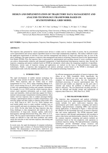
The International Archives of the Photogrammetry, Remote Sensing and Spatial Information Sciences, Volume XLIII-B4-2020, 2020XXIV ISPRS Congress (2020 edition)DESIGN AND IMPLEMENTATION OF TRAJECTORY DATA MANAGEMENT ANDANALYSIS TECHNOLOGY FRAMEWORK BASED ONSPATIOTEMPORAL GRID MODELJ. Li 1, , J. Q. Liu 1 * , X. L. Mei 1, W. T. Sun 1, Q. Huang 2, Y. Y. Zhang 1, L. W. Qiao 1, C. Y. Zhang11College of Geoscience and Surveying Engineering, China University of Mining and Technology, Beijing 100083, China –junli@cumtb.edu.cn, (juq.liu, xl.mei, wt.sun, yy.zhang, lw.qiao)@student.cumtb.edu.cn, czhang@cumtb.edu.cn2Service Lab, Huawei Research Institute, Huawei Technology Co. Ltd, Beijing 100095, China –huangqian16@huawei.comKEY WORDS: Trajectory Representation, Trajectory Data Management, Trajectory Analysis, Spatiotemporal Grid ModelABSTRACT:The trajectory data generated by various position-aware devices is widely used in various fields of society, but its conventionalvector representation and various analysis algorithms based on it have high computational complexity. This makes it difficult to meetthe application requirements of real-time or near real-time management and analysis of large-scale trajectory data. In view of theabove challenges, this paper proposes a trajectory data management and analysis technology framework based on the SpatiotemporalGrid Model (STGM). First, the trajectory data is represented by spatiotemporal grid encoding instead of vector coordinates, and itcan achieve dimensionality reduction and integrated management of high-dimensional heterogeneous trajectory data. Second, thetrajectory computing and analysis methods based on STGM are introduced, which reduce the computing complexity of algorithms.Furthermore, various types of trajectory mining and applications are realized on the basis of high-performance computingtechnologies. Finally, a trajectory data management and analysis prototype system based on the STGM is developed, andexperimental results verify the reliability and effectiveness of the proposed technology framework.1. INTRODUCTIONThe rapid development of mobile internet technology hasspawned a large amount of mobile trajectory data (Wu et al.,2019). These trajectory data are widely used in smarttransportation (Li et al., 2012), urban computing (Zheng et al.,2015), social sensing (Liu et al., 2015) and other fields becauseof their rich spatiotemporal location and semantic information.For example, Li et al. (2019) used the vehicle trajectory data toextract coach operation information such as coach stations,routes and timetables, which provided data support for China’snational road passenger transportation ticketing platform. Somestudies used taxi trajectory data to conduct passenger-findingstrategies, spatiotemporal analysis of public transportation, roadnetworks update and other studies to optimize urban traffic (Wuet al., 2016; Tang et al., 2017; Tu et al., 2018). Scholars alsoused mobile phone traces to study residents' mobility laws toassist scientific and smart city planning (Jiang et al., 2013; Chenet al., 2018). On the other hand, the huge trajectory data alsobring challenges to data management and analysis due to itscharacteristics of large-scale, dynamic update, multi-sourceheterogeneity and high-dimensional (Feng, Zhu, 2016; Li et al.,2016). The two typical representation models (vector and rastermodel) are difficult to cope with those problems and cannotsatisfy the real-time or near real-time trajectory data mining andapplication needs.In recent years, the rapid development of computer technologyhas promoted rapid evolution of Discrete Global Grid System(DGGS). The characteristics of discreteness, multi-level, andlow-dimensional of DGGS provide a new research perspectivefor efficient management and analysis of massive trajectory data(Zhou et al., 2009; Goodchild, 2018). Specifically, thediscreteness of DGGS not only meets the requirements ofcomputer for discretizing storage, but also facilitates thedistributed processing of massive spatiotemporal data. Themulti-level grid models can adaptively use the grid code tocalculate and analyze the problems at different scales toimprove efficiency. The low-dimensional encoding provides abasis for efficient and flexible storage and organization oftrajectory data (Chen et al., 2002; Purss et al., 2016).2. THE FRAMEWORK DESIGNThe trajectory data management and analysis technologyframework based on the Spatiotemporal Grid Model (STGM)mainly includes five parts: multi-source trajectory data,spatiotemporal grid model, trajectory computing and analysismethods, high-performance computing (HPC) and trajectorymining applications, as illustrated in Figure 1, which providesthe solutions for the knowledge discovery of massive trajectorydata and various applications. The STGM represents multisource trajectory data through spatiotemporal grid encoding toachieve data fusion and dimensionality reduction. On this basis,the common trajectory computing and analysis methods aretransformed based on the low-complexity code operations toaccelerate trajectory mining. The high-performance computingtechnologies provide distributed storage resources andconcurrent computing resources. On the top are various types oftrajectory mining and applications.* Corresponding authorThis contribution has been es-XLIII-B4-2020-471-2020 Authors 2020. CC BY 4.0 License.471
The International Archives of the Photogrammetry, Remote Sensing and Spatial Information Sciences, Volume XLIII-B4-2020, 2020XXIV ISPRS Congress (2020 edition)Trajectory Mining tionmonitoringEpidemiccontactstrackingHigh Performance Computing,HPCNearbyVehicleSearchRoad mapupdate Trajectory computing and Analysis sisSpatiotemporal Grid Model, STGMGridsubdivisiontheorySpatiotemporalgrid encodingGrid codecoordinateconversionMulti-scalegrid coderepresentationBasicoperators ofgrid codeMulti-source Trajectory dataTaxi trajectorydataSocial mediadataBus IC carddata Mobile Phonesignaling dataFigure 1. Technology framework of trajectory data management and analysis based on the STGM2.1 Spatiotemporal Grid ModelThe STGM uses the grid subdivision theory and spatial gridencoding technology to replace the vector floating-pointcoordinates with local unit address codes (Cui et al., 2007; Sunet al., 2008; Wan, Cao, 2016; Qian et al., 2019; Guo et al., 2019)(Figure 2a). Then, the time dimension is taken into account torealize the one-dimensional encoding representation of spacetime information. Furthermore, the trajectory data is mapped tothe spatiotemporal grids to realize multi-scale codingrepresentation (Figure 2b). In this way, the dimensionalityreduction of the high-dimensional trajectory data is achieved,which greatly reduces the complexity of trajectory data storage,management and analysis. What's more, the STGM developsthe conversion function between grid code and coordinates.Finally, two basic operators—proximity grid code query andspatial geometric measurement are developed, and they providethe foundation for upper-layer trajectory analysis 021233(a)01021000(b)Figure 2. Spatiotemporal grid model, (a) Spatial grid coding,(b) Multi-scale coding representation of trajectoryThis contribution has been es-XLIII-B4-2020-471-2020 Authors 2020. CC BY 4.0 License.472
The International Archives of the Photogrammetry, Remote Sensing and Spatial Information Sciences, Volume XLIII-B4-2020, 2020XXIV ISPRS Congress (2020 edition)2.2 Trajectory Computing and Analysis MethodsThe change of the trajectory data representation model willinevitably lead to reformation of the upper-level trajectoryanalysis algorithms. It is necessary to fully make use of thetrajectory grid code representation characteristics to reform orimprove a set of computing and analysis methods based mainlyon the following strategies: a) The fast query of trajectories isrealized based on the structural characteristics of "grid-coding isindexing, indexing is grid-coding", such as spatiotemporalproximity query and road matching with trajectory points. Thebasic idea is to organize the trajectory codes as a data index, sothe trajectory query can be implemented on the index layer,which greatly accelerates the query operation of trajectories. Inaddition, instructed by the principle that the code prefixes oftrajectories in the same grid are close in time and space, the fastspatiotemporal query can be achieved using code matching. b)The trajectory analysis algorithms can be transformed by a setof low complexity of code operations, such as trajectorydistance measurement. The classical trajectory distancemeasurement algorithms include Dynamic Time Warping(DTW) (Keogh et al., 2000), Longest Common Subsequence(LCSS) (Vlachos et al., 2002), Edit Distance on Real sequence(EDR) (Chen et al., 2005), Fréchet distance (Fréchet et al., 1906)and Hausdorff distance (Lee et al., 2007). The time complexityof these methods is O(n*m) (n and m are the number of pointsof the two trajectories respectively), which makes thecalculation very time-consuming. Nevertheless, the trajectorydistance based on grid code can be calculated through theJaccard distance, Simpson coefficient, dice coefficient etc.,which are very fast calculation operations. On the basis of this,most other trajectory analysis algorithms can be transformed,simplified and accelerated, such as trajectory similarity analysis,trajectory clustering. c) The flexibility of trajectory computingand analysis can be realized by the multi-scale grid coderepresentation of trajectory. Although the classical vectorcoordinates have a high accuracy, it is difficult to handle crossscale analysis tasks such as a multi-mode traffic travel analysis,including large-scale flight trajectories, medium-scale intra-cityand inner-city trajectories, and walking trajectories at a smallscale. Based on the grid code, the cross-scale analysis can beeasily achieved by selecting the trajectory codes at suitablescales. d) The multi-scale characteristics of trajectory codes canalso serve for visual analysis. The trajectory data at acorresponding scale is visualized according to the scale of webview range to accelerate the visual analysis, which is similar tothe image pyramid structure.2.3 High Performance ComputingIn the era of big data, the mining of massive trajectory dataoften requires the support of high-performance computingframeworks such as parallel computing and distributedcomputing (Gao et al., 2017). The STGM's discretecharacteristic can be well combined with high performancecomputing, which realizes the distributed storage andconcurrent computing of big trajectory data, and providesbidirectional power for the management and analysis oftrajectory data. The specific performance includes: First, thetrajectory codes are discretized by slices (time slices), layers(different grid-coding levels), and blocks (space cells), andstored in existing distributed storage systems, such asMongoDB, HBase, PostgreSQL and other distributed databases,to achieve storage and management of massive trajectories.Then, the trajectory data is automatically distributed to eachnode under the distributed computing framework (such asHadoop, Spark) or GPU parallel computing frameworks. Finally,the concurrent query and computing of massive trajectory datais implemented.2.4 Trajectory Mining ApplicationsTrajectory mining applications often require frequent or realtime services with high time efficiency, such as regular updatesof road maps, real-time search of nearby vehicles, rapid filteringof epidemic contacts, real-time monitoring of traffic conditions,aircraft collision detection. The proposed trajectory datamanagement and analysis technology framework based on theSTGM uses the advantages of trajectory grid coding toaccelerate trajectory computing and analysis, which makes itpossible to meet these real-time or near real-time applicationrequirements. For example, (a) for the real-time dispatch ofmassive taxies, the proposed technology framework can quicklygather people’s travel demand, simultaneously conduct realtime query of nearby taxies, and provide solutions for intelligentdispatch of taxis and peak hour pricing service. (b) For thefiltering of epidemic contacts, we can take a large-scaleindividual trajectories as the target, and conduct similartrajectory analysis based on STGM to quickly identify and tracksuspected epidemic contacts among a large number of people toblock the virus transmission chain. (c) In order to solve theproblem of collision detection among flying aircrafts in a largescale, real-time scenario, the flying trajectories of aircrafts aregrid-coded based on STGM. Then, the inclusion judgmentbased on grid codes is used to improve the efficiency of aircraftcollision detection and ensure the flight safety of aircrafts(Zheng et al., 2019).3. EXAMPLE OF APPLICATIONBased on the above theory and technology, a trajectory datamanagement and analysis prototype system based on the STGMwas developed (Figure 3). The system manages all the taxitrajectory data of Beijing, China, a total of approximately70,000 taxis, generating approximately a dozen GB of trajectorydata every day.The trajectory analysis functions include spatiotemporalproximity query of trajectory, top-k similar trajectory query andother functions. The spatiotemporal proximity query oftrajectory outputs adjacent trajectories of a target trajectorywithin a specific radius of a certain space-time position (Figure4a). Experimental results validate that the proximity queryunder tens of millions of trajectory points can be finished in lessthan a second with the grid index. Top-K similar trajectoryquery is to get the most K similar trajectories of a targettrajectory in a large-scale dataset (Figure 4b). The systemrealizes fast query of similar trajectories through multi-scalecode and highly efficient code operations. Experimental resultsshow that the computing time is shortened by about two ordersof magnitude with a similar accuracy, compared with the classictrajectory similarity analysis algorithms (e.g. DTW, LCSS,EDR). The multi-scale trajectory density calculation modulecalculates the trajectory density in each grid, and realizes fastswitching among different view ranges (Figure 4c).This contribution has been es-XLIII-B4-2020-471-2020 Authors 2020. CC BY 4.0 License.473
The International Archives of the Photogrammetry, Remote Sensing and Spatial Information Sciences, Volume XLIII-B4-2020, 2020XXIV ISPRS Congress (2020 edition)Figure 3. Interface of trajectory data management and analysis prototype system based on STGM(a)(b)(c)Figure 4. Examples of trajectory analysis tools in the system, (a) Spatiotemporal proximity query of trajectory, (b) Top-k similartrajectory query, (c) Fast calculation of multi-scale trajectory densityThis contribution has been es-XLIII-B4-2020-471-2020 Authors 2020. CC BY 4.0 License.474
The International Archives of the Photogrammetry, Remote Sensing and Spatial Information Sciences, Volume XLIII-B4-2020, 2020XXIV ISPRS Congress (2020 edition)4. CONCLUSIONThis paper proposes a trajectory data management and analysistechnology framework based on the STGM, which mainlyincludes five parts: heterogeneous multi-source trajectory data,STGM, HPC, trajectory computing and analysis methods, andtrajectory mining applications. In addition, we analyze andsummarize the advantages and characteristics of storingtrajectory data and simplifying the analysis algorithms based onspatiotemporal grid-coding. The computing and analysisalgorithms of trajectory data are accelerated by using thefeatures of grid index, multi-scale coding, and transformedanalysis algorithms, which provide the possibility for real-timeor near real-time trajectory mining applications. Finally, wedeveloped a trajectory data management and analysis prototypesystem based on the STGM, which verified the effectiveness ofthe theories and technical methods presented in the paper. Thiswork provides technical support for the management andanalysis of massive trajectory data in future, and better servesvarious fields such as smart transportation, urban computing,city planning and social sensing.ACKNOWLEDGEMENTSThis research is financially supported by National NaturalScience Foundation of China (No. 41971355), the Open Projectof State Key Laboratory of Resources and EnvironmentalInformation System, Huawei Corporation and the Yueqi YoungScholars Program of China University of Mining andTechnology at Beijing.REFERENCESGuo, N., Xiong, W., Wu, Y., Chen, L., Jing, N., 2019: Ageographic meshing and coding method based on adaptiveHilbert-Geohash. IEEE Access, 7, 39815-39825.Jiang, S., Fiore, G.A., Yang, Y., Ferreira Jr, J., Frazzoli, E.,González, M.C., 2013. A review of urban computing for mobilephone traces: current methods, challenges and opportunities.In Proceedings of the 2nd ACM SIGKDD internationalworkshop on Urban Computing (pp. 1-9).Keogh, E.J., Pazzani, M.J., 2000. Scaling up dynamic timewarping for datamining applications. In Proceedings of the sixthACM SIGKDD international conference on Knowledgediscovery and data mining, 285-289.Lee, J.G., Han, J., Whang, K.Y., 2007. Trajectory clustering: apartition-and-group framework. In Proceedings of the 2007ACM SIGMOD international conference on Management ofdata, 593-604.Li, J., Li, Q., Zhu, Y., Ma, Y., Xu, Y., Xie, C., 2019: AnAutomatic Extraction Method of Coach Operation Informationfrom Historical Trajectory Data. Journal of AdvancedTransportation, 2019, 2019(PT.1):449-463.Li, J., Qin, Q., Xie, C., Zhao, Y., 2012: Integrated use of spatialand semantic relationships for extracting road networks fromfloating car data. International Journal of Applied EarthObservation and Geoinformation, 19, 238-247.Li, J., Wang, J., Zhang, J., Qin, Q., Jindal, T., Han, J., 2016: Aprobabilistic approach to detect mixed periodic patterns frommoving object data. Geoinformatica, 20(4), 715-739.Chen, B.Y., Wang, Y., Wang, D., Li, Q., Lam, W.H., Shaw,S.L., 2018: Understanding the impacts of human mobility onaccessibility using massive mobile phone tracking data. Annalsof the American Association of Geographers, 108(4), 11151133.Liu, Y., Liu, X., Gao, S., Gong, L., Kang, C., Zhi, Y., Chi, G.H.,Shi, L., 2015: Social sensing: A new approach to understandingour socioeconomic environments. Annals of the Association ofAmerican Geographers, 105(3), 512-530.Chen, L., Özsu, M.T., Oria, V., 2005. Robust and fast similaritysearch for moving object trajectories. In Proceedings of the2005 ACM SIGMOD international conference on Managementof data, 491-502.Purss, M.B., Gibb, R., Samavati, F., Peterson, P., Ben, J., 2016.The ogc discrete global grid system core standard: Aframework for rapid geospatial integration. In 2016 IEEEInternational Geoscience and Remote Sensing Symposium(IGARSS) (pp. 3610-3613).Chen, S. P., Zhou, C.H., Chen, Q.X., 2002: Grid mapping andgrid computing. Science of Surveying and Mapping 27, no. 4, 16.Cui, M.J., Zhao, X.S., 2007: Tessellation and distortion analysisbased on spherical DQG. Geography and Geo-InformationScience, 23(6), 23-25.Feng, Z., Zhu, Y., 2016: A survey on trajectory data mining:Techniques and applications. IEEE Access, 4, 2056-2067.Fréchet, M.M., 1906: Sur quelques points du calculfonctionnel. Rendiconti del Circolo Matematico di Palermo(1884-1940), 22(1), 1-72.Gao, Q., Zhang, F.L., Wang, R.J., Zhou, F., 2017. Trajectorybig data: a review of key technologies in data processing. J.Softw, 28(4), 959-992.Goodchild, M.F., 2018: Reimagining the history of GIS. Annalsof GIS, 24(1), 1-8.Qian, C., Yi, C., Cheng, C., Pu, G., Wei, X., Zhang, H., 2019:Geosot-based spatiotemporal index of massive trajectorydata. ISPRS International Journal of Geo-Information, 8(6),284.Sun, W., Cui, M., Zhao, X., Gao, Y., 2008. A global discretegrid modeling method based on the spherical degeneratequadtree. In 2008 International Workshop on EducationTechnology and Training & 2008 International Workshop onGeoscience and Remote Sensing. IEEE, (Vol. 2, pp. 308-311).Tang, L., Sun, F., Kan, Z., Ren, C., Cheng, L., 2017:Uncovering distribution patterns of high performance taxis frombig trace data. ISPRS International Journal of GeoInformation, 6(5), 134.Tu, W., Cao, R., Yue, Y., Zhou, B., Li, Q., Li, Q., 2018: Spatialvariations in urban public ridership derived from GPStrajectories and smart card data. Journal of TransportGeography, 69, 45-57.This contribution has been es-XLIII-B4-2020-471-2020 Authors 2020. CC BY 4.0 License.475
The International Archives of the Photogrammetry, Remote Sensing and Spatial Information Sciences, Volume XLIII-B4-2020, 2020XXIV ISPRS Congress (2020 edition)Vlachos, M., Kollios, G., Gunopulos, D., 2002. Discoveringsimilar multidimensional trajectories. In Proceedings 18thinternational conference on data engineering. IEEE, 673-684.Wan, G., Cao, X.F., 2016: The Historical Evolution andReflection of Geospatial Information Grid. Acta Geodaetica etCartographica Sinica, 45(S1), 15-22Wu, H.Y., Huang, R., You, L., Xiang, L.G., 2019: RecentProgress in Taxi Trajectory Data Mining. Acta Geodaetica etCartographica Sinica, 48(11), 1341-1356.Wu, T., Xiang, L., Gong, J., 2016: Updating road networks bylocal renewal from GPS trajectories. ISPRS InternationalJournal of Geo-Information, 5(9), 163.Zheng, Y., 2015: Trajectory data mining: an overview. ACMTransactions on Intelligent Systems and Technology (TIST),6(3), 1-41.Zheng, Y., Liu, J., Li, J., Xu, Y., Huang, Q., Zhu, Y., Pei, Y.,2019. Design of Fine Management System for Civil AviationAirspace Resources Based on Spatiotemporal Grid Model.In 2019 IEEE 1st International Conference on Civil AviationSafety and Information Technology (ICCASIT), 547-551.Zhou, C.H., Ou, Y., Ma, T., 2009: Progresses of geographicalgrid systems researches. Prog. Geogr, 28, 657-662.This contribution has been es-XLIII-B4-2020-471-2020 Authors 2020. CC BY 4.0 License.476
The change of the trajectory data representation model will inevitably lead to reformation of the upper-level trajectory analysis algorithms. It is necessary to fully make use of the trajectory grid code representation characteristics to reform or improve a set of computing and analysis methods based mainly