Transcription
EPA Region ISDMSDOCID465583ProposedSuperfund Program PlanHolton Circle Superfund SiteLondonderry, New Hampshire Superfund Records CeuterJune 1992SITE: To i BREAK:OTHER: cira }3.SEPA Proposes Cleanup Planfor the Holton Circle Superfund SiteT! he U.S. Environmental Protection Agency (EPA) is proposing a cleanupplan, referred to as a preferred altemative, to address groundwatercontamination at the Holton Circle Superfund Site (site) in Londonderry,New Hampshire. This Proposed Plan describes the preferred altemative whichwas chosen from cleanup options evaluated during the Feasibility Study (FS)'performed for the site. In addition to describing EPA's preferred altemative,this Proposed Plan discusses the other cleanup measures evaluated during theRemedial Investigation (RI) and FS to address contamination at the site.In accordance with Section 117(a) of the Comprehensive EnvirorunentalResponse, Compensation, and Liability Act (CERCLA), EPA is publishing thisProposed Plan to provide an opportunity for public review and comment onthe cleanup options, known as remedial alternatives, under consideration forthe site. EPA will consider public comments as part of the final decision-mak ing process for selecting a cleanup remedy for the site.EPA's preferred altemative involves 1) natural attenuation of groundwatercontaminants, 2) institutional controls to prevent access to contaminatedgroundwater, and 3) a groundwater monitoring program to confirm theprogress of natural attenuation and assure residential wells remain safe for use.An alternate water supply contingency is available in the urdikely circumstancethat residential wells currently in use for drinking water purposes shouldbecome contaminated above cleanup levels established by EPA. The preferredaltemative is described in greater detail on pages 10 through 11 of this docu ment. Other alternatives considered during the FS are summarized on pages 11through 14.This Proposed Plan:1. Explains the opportvmities for the public to comment on the remedialaltematives;2. Includes a brief history of the site and the principal findings of siteinvestigations;3. Provides a brief description of the preferred altemative and otheraltematives evaluated in the FS;4. Outlines the criteria used by EPA in evaluating each altemative foruse at the site, and briefly analyzes whether the altematives meeteach criterion; and'Words in bold type are described in the glossary at the end of this document.
5. Presents EPA's rationale for its preliminary selection of the preferredaltemative.To help the public participate in reviewing the cleanup options for the site,this document also explains where interested citizens can find more detaileddescriptions of the remedy selection process and the altematives under consid eration for the Holton Circle site.The Public's Role in Evaluating RemedialAlternativesPublic Informational MeetingEPA will hold a public informational meeting on Tuesday, Jtme 30,1992 at7:30 p.m. at the Londonderry High School, located at 295 Mammoth Road inLondonderry, New Hampshire. EHiring the meeting, EPA staff will describe thepreferred altemative and other altematives evaluated in the FS. The public isencouraged to attend the meeting to hear the presentations and to ask ques tions.Public Comment PeriodEPA is conducting a 30-day public comment period from July 1 to July 30,1992, to provide an opportunity for public involvement in the final cleanupdecision. During the comment period, the public is invited to review thisProposed Plan, and the Remedial Investigation (RI) and FS reports which arelocated at the information repositories, and to offer written comments to EPA.Informal Public HearingEPA will also hold an informal public hearing on Tuesday, July 21,1992 at7:30 p.m. at the Londonderry High School, 295 Mamnioth Road, Londonderry,New Hampshire, to accept oral conunents on the cleanup altematives vinderconsideration for the site. This hearing wiU provide an opportimity for citizensto comment on the cleanup plan after they have heard the presentations madeat the public informational meeting and reviewed this Proposed Plan. Citizensare encouraged to pose any site-related questions or concems during the publicinformational meeting on Jvme 30, which will be responded to at that time bythe EPA panel. Questions asked during the public hearing wiU not be re sponded to directly, but wiU be addressed in writing and included in a Respon siveness Summary. The Responsiveness Summary will respond to all verbaland written comments received during the comment period. The hearing willbe transcribed, and a copy of the transcript wiU be added to the site Adminis trative Record available at the EPA Records Center at 90 Canal Street in Boston,MA, and at the local information repository listed on page 3.Written CommentsIf, after reviewing the information on the site, you would like to comment inwriting on EPA's preferred altemative, any of the other cleanup altemativesconsidered during the FS, or other issues relevant to the site cleanup, pleasedeliver yovir comments to EPA at the public hearing or mail your writtencomments (postmarked no later than July 30,1992) to:Envirorunental Protection Agency Proposed Plan Holton Circle Superfimd Site2
James DiLorenzo, Remedial Project ManagerU.S. Envirorunental Protection AgencyWaste Management Division (HSN-CAN5)JFK Federal BuildingBoston, MA 02203-2211(617) 223-5510EPA's Review of Public CommentEPA will review all written and oral comments received from the public aspart of the process of reaching a final decision on the most appropriate reme dial altemative, or combinations of altematives, for cleanup of the HoltonCircle site. EPA's final choice of a remedy wiU be issued in a Record of Deci sion (ROD) for the site this Fall. A document known as a ResponsivenessSummary, which summarizes EPA's responses to conunents received duringthe public connment period, will be issued with the ROD. Once the ROD issigned by the EPA Regional Administrator, it will become part of the Adminis trative Record which contains all docvunents used by EPA in choosing a rem edy for the site.Additional Public InformationBecause this Proposed Plan provides only a summary description of theinvestigation of the Holton Circle site and the cleanup altematives considered,the public is encouraged to consult the Administrative Record, which containsthe Rl and FS reports. These documents provide a more detailed explanation ofthe site and each of the remedial altematives vmder consideration.The Administrative Record is available for review at the following locations:EPA Records Center90 Canal Sh-eet, 1st FloorBoston, Massachusetts 02114(617) 573-5729Hours:Monday-Friday: 10:00 a.m. to 12:00 p.m.and 2:00 p.m. to 5:00 p.m.Leach Public Library276 Mammotii RoadLondonderry, New Hampshire(603)432-1132Hours:Monday, Wednesday: 9:00 a.m. - 6:00 p.m.Tuesday, Thursday: 10:00 a.m. - 8:00 p.m.Friday: 9:00 a.m. - 5:00 p.m.Saturday: Closed July-SepteinberSunday: ClosedEnvironmental Protection Agency Proposed Plan Holton Circle Superfund Site3
Fig. 1 - Site Location MapDrawing Not to ScaleEnviroim ental Protection Agency Proposed Plan Holton Circle Superfund Site4
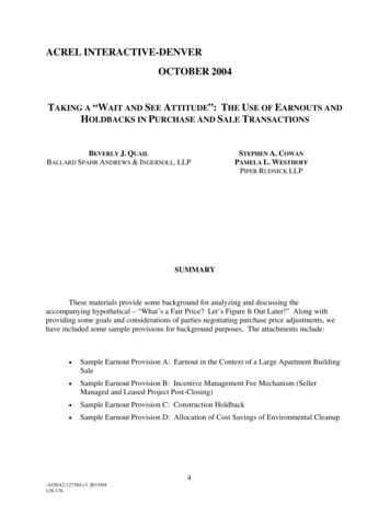
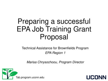
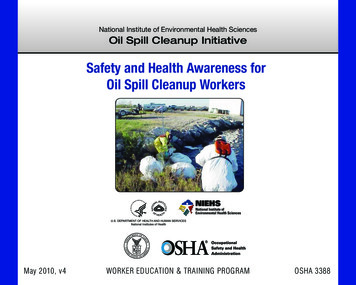
Site HistoryThe Holton Circle Superfund Site is located north of Pillsbury Road near theintersection of Pillsbury and High Range Roads in Londonderry, New Hamp shire. The site encompasses a residential development (Holton Circle) of 23homes, the Londonderry town garage area located off High Range Road, and anundeveloped HiU Slope and wetlands area between Holton Circle and the tov«igarage, (see Figure 1 Site Location Map).From approximately 1943 through 1947, the property now known as thetown garage area was used as a radio beacon facility by the U.S. Army. Since1971, the town garage area has been vised for road equipment storage andvehicle maintenance, in addition to being a sand and road salt storage area.Construction of the Holton Circle residential development began around1975. Contamination at the Holton Circle site was discovered in 1984 whenseveral residents of the Holton Circle neighborhood complained of the deterio rating quality of the water from their private weUs, which are drilled into bed rock. WeU testing by the New Hampshire Department of Environmental Ser vices (NHDES) revealed the presence of elevated levels of volatile organiccompounds (VOCs) in several wells within the Holton Circle development andin the bedrock well which services the town garage.Ehjring 1989 a Southern New Hampshire Water Company (SNHWC) publicwater supply service was extended to Holton Circle and the adjacent IsabellaDrive development. A number of the residents on Holton Circle have chosen toconnect to this water supply. All residents of Isabella Drive, which is currentlyundergoing development, are connected to the water supply and do not haveprivate wells.EPA Activities to DateEPA's involvement with the site began following the discovery by theNHDES of contaminants in the residential wells. EPA completed a PreliminaryAssessment (PA) of the site in 1985 which confirmed the presence of VOCs inresidential drinking water wells and in the town garage well. The major con taminants detected include 1,1-dichloroethene (1,1 DCE) and 1,1 dichloroethane (1,1 DCA), at levels which were above state and federal drink ing water standards. To date, VOCs have been detected in residential wells at 12of the 23 homes in the Holton Circle development. In addition, elevated levels ofchloride, sodium, calcium and other salt-related substances have also beendetected at the site. In 1989, the site was placed on EPA's National PrioritiesList (NPL) of priority releases making it eligible for federal funding for remedialevaluation and response activities.In March 1990, EPA began work on a Remedial Investigation (Rl). The objec tives of the RI were to assess the current level of groundwater contamination inthe Holton Circle residential wells, identify the nature and extent of contamina tion at the site in all media, and determine a source of the contamination. Theinitial sampling round conducted by EPA confirmed the presence of VOCs ingroundwater, however, contaminant concentrations were found to be lowerthan previously detected.The results of periodic well sampling by EPA and NHDES indicate that, ingeneral, contaminant concentrations in residential weUs have either decreased orremained constant from 1984 through the present. Levels of VOCs in the resi dential weUs are currently at or below all federal and state safe drinking waterstandards, including Maximum Contaminant Levels (MCLs). There are curEnviromnental Protection Agency Proposed Plan Holton Circle Superfund Site5
rently no residential wells in use for drinking water purposes that have con taminant levels above MCLs, nor does EPA anticipate that levels wiQ exceeddrinking water standards in the future.Results of the Remedial InvestigationEHiring the RI, EPA conducted field activities which included sampling soiland groundwater throughout the site. Based on results from the sampling andgeophysical activities, the investigation focused on the town garage area as thesuspected source area of the contamination. The final RI report was completedby EPA in March 1992. The analytical results of the RI confirm that VOCs arethe principal contaminants at the site, and are found in both the overburdenand bedrock groundwater aquifers. Contaniination by VOCs was also detectedin surface and subsurface soils and wetland sediments at concentrations wellbelow levels of concem. EPA also determined that elevated sodium, chlorideand other salt-related substances contaminants found in groundwater are theresult of leaching from an open salt storage area at the garage which waspresent until 1985.Despite a comprehensive sampling and subsurface investigation, no specificsource for the VOC groundwater contamination was identified during the RI.The field investigation did not reveal any evidence of buried drums, tanks orelevated soil concentratiorvs definitive of a specific continuing source in thetown garage. However, the RI concluded that the Londonderry town garagearea is the source area of the VOC contamination as evidenced by groundwatercontaminant concentration and flow patterns. Copies of the RI report areavailable for public review at the information repositories listed on page 3. Thefindings of the field investigation are discussed in detail in the RI and aresvmunarized below.1. Groundwater Quality: Groundwater quality in both the overburden andbedrock aquifers was characterized during the RI. Groundwater in overburdenand bedrock wells immediately downgradlent of the town garage area exhibitthe highest VOC concentrations. Concentrations of 1,1,1-Trichloroethane (1,1,1TCA) and 1,1 DCE above federal drinking water standards are present in theoverburden aquifer and in the bedrock aquifer near and immediatelydownngradient of the town garage area. Elevated levels of 1,1 DCA and 1,1 DCEabove federal and state drinking water standards have been detected in bed rock weUs in the residential area, although VOC levels are now at or belowthose standards. These analytical results support the RI report, which indicatesthat the contaminants may be undergoing degradation during movement awayfrom the town garage area. The most recent sampling rounds and analyseshave fovmd aU contaminant levels in residential drinking water wells at orbelow federal and state drinking water standards.Elevated levels of chloride, sodium, and other salt-related substances arepresent in both the overburden and bedrock aquifers downgradlent of the towngarage area. No prinnary, enforceable federal or state drinking water standardexists for chloride, sodium or the other salt-related substances. In general,chloride and sodivim levels are higher in the bedrock aquifer than in theoverburden, and often exceed secondary drinking water standards, which arenot health related, but are related to the aesthetic qualities of water (i.e. tasteand smeU). Health studies have shown that ingestion of excess sodium maylead to hypertension in certain persons. Elevated calcivim levels have beenshov m to cause water hardness.Environmental Protection Agency Proposed Plan Holton Circle Superfund Site6
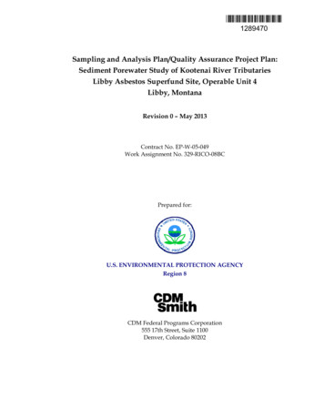
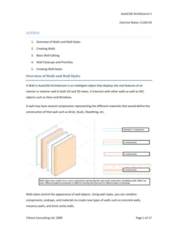
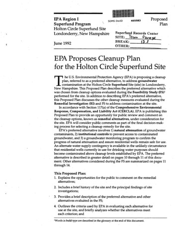
Fig. 2 - Holton Circle Site Map .yd/L.\i .y sdz. .xl.'.wLc.Drawing Not to Scalesii . WetlandsApproximate BedrockContamination AreaTown GarageProperty FenceRadio BeaconArea40 :: :: :-.;Approximate Overburdencontamination ArcdTown dwaterEnvironmental Protection Agency Proposed Plan Holton Circle Superfund Site7
Several metallic compounds including arsenic, lead, barium, beryllium,chromivim and antimony were detected in the groundwater during one roundof sampUng conducted dviring the RI. Levels of barium and chromium weresUghtly above MCLs. EPA believes that the metals detected are not representa tive of site conditions, and is proposing to analyze future groundwater samplesfor metals concentrations to confirm actual site conditions with respect tometals.2. Groimdwater Flow: Overburden and bedrock groundwater flows fromthe town garage area to the northeast-east, toward the wetland area and HoltonCircle. According to the RL pliunes of VOCs originating in the town garagearea and extending toward the residential weUs in the Holton Circle subdivi sion are present in both the overbvirden and bedrock groundwater, see Figure 2,Holton Circle Site Map. Contaminant concentrations within the plumes de crease with distance from the town garage, in the direction of the wetland andHolton Circle. Grovmdwater held within the overburden discharges primarilyinto the wetland.Unlike the overburden plume, the bedrock groundwater contaminationflows from the town garage area under the wetland and extends into theHolton Circle subdivision. The contaminants which have affected several wellsin the Holton Circle subdivision appear to be migrating from the town garagearea by grovmdwater transport through the bedrock aqviifer. The RI reveals thatthe overburden aquifer is recharging the bedrock aquifer near the town garagearea only, so that contaminants which may have been originally released to theshallow water table by a spUI or leak may sink and flow through cracks in thebedrock and contaminate the bedrock aquifer located further below.The town garage is located on a small knoU. During the Remedial Investiga tion, overburden groundwater was found to be affected by a hydrogeologicdivide located to the west of the town garage building in the town garage area.The divide is oriented in a north/south direction and separates the groundwa ter in the Radio Beacon Area from the rest of the site, see Figure 2, Holton CircleSite Map. In general, overburden grovmdwater to the east of this divide, wherethe VOC plume exists, flows toward the wetland; overburden groundwater tothe west of the divide flows toward the Radio Beacon Area.3. Soils: Volatile organic compounds (VOCs) including low levels of ac etone, commonly used as solvents, were the predominant chemicals detected insoils. In general, soils contaminated by acetone and other VOCs were detectedsporadically within shallow soils in the town garage yard. Other organic chemi cals such as petroleum hydrocarbons and other fuel products were detected inlow levels throughout shallow soils, in the town garage area. There are no soilson site which require remediation.4. Surface Water: Two areas of the site were characterized as surface waterbodies during the RI and were sampled as such. One surface water samplingarea is a small, intermittent pond which serves as a drainage retention pond.The drainage pond is located to the north and downgradlent of the towngarage. The RI indicates that the pond is also a discharge area for overburdengroundwater. Surface water in the downgradlent wetland area near HoltonCircle was also sampled. The wetland area was determined to also serve as adischarge point for overburden groundwater and surface water drainage.Samples from both surface water areas revealed elevated chloride concen trations but did not reveal elevated VOCs.Environmental Protection Agency Proposed Plan Holton Circle Superfund Site8
Holton Circle RI report which is available at the information repository at theLeach Public Library.Proposed Cleanup Objectives and LevelsUsing the information gathered dviring the Remedial Investigation (RI),Feasibility Study (FS) and Risk Assessment, EPA developed the followingobjectives to define cleanup actions required to eliminate risks of groundwatercontamination at the Holton Circle site:1. Prevent ingestion of water which contains compounds in concentra tions that exceed federal and state enforceable drinking water stan dards; and2. Prevent ingestion of water containing compounds which have noenforceable federal or state drinking water standards but which posean vinacceptable health risk.To meet these objectives, EPA has established site-specific cleanup levelsthat will be protective of public health and the envirorunent. Clean-up levelshave been established for 1,1 DCE, and 1,1,1 TCA. Several inorganic com pounds (i.e. metals) including arsenic, chromium, barium, beryllium, lead andantimony were detected at the site dviring one round of groundwater samplingfor inorganic compovmds. Barium and chromivim were each found at concen trations slightly in excess of MCLs. Since the detection of inorganic compovmdswere sporadic and at low levels, EPA expects that these concentrations are notrepresentative of actual conditions at the site, and therefore no specific cleanupof these inorganic compovmds is proposed. Additionally, the metals present atthe site are typically found in soUs and groundwater across the State of NewHampshire. EPA will continue to monitor the presence of these metals ingroundwater during the remedial activities.EPA's Preferred AltemativeEPA's selection of the preferred cleanup altemative for the Holton Circle siteis the result of a comprehensive evaluation process. The FS was conducted toidentify different clean-up altematives and evaluate possible treatment tech nologies.The FS report for the Holton Circle site describes in detail the five remedialaltematives corvsidered, as well as the process and criteria EPA used to evaluatethe remedial altematives. For details on EPA's altemative evaluation process,see Sections 3.0 and 4.0 of the FS. The following sections describe EPA's pre ferred altemative, as well as the other four altematives which were evaluatedby EPA to address the contamination at the site.After conducting a detailed analysis of the feasible cleanup alterr tives, andevaluating the risks posed by the site contamination, EPA has proposed Alter native 2 — Limited Action, to address groundwater contamination at theHolton Circle site. EPA's preferred altemative would allow the groundwatercontaminant levels to decrease naturally over time, and would also involveinstitutional controls to limit the potential for human exposure to contaminatedgroundwater.Under this altemative, natural attenuation processes would be relied uponto remediate both the overburden and bedrock groundwater aquifers. Naturalattenuation is a process where groundwater is allowed to remediate naturallywithout intervention or treatment. Institutional controls, including placementEnvironmental Protection Agency Proposed Plan Holton Circle Superfund Site10
5. Sediment: Sediment samples were taken from the wetland area west ofHolton Circle and from the outlet of the drainage pipe which is connected to afloor drain which exists in the town garage building. Analysis of the sedimentsamples from the outlet of the drainage pipe and the wetland area indicates thepresence of VOCs similar to those found in groundwater, except at concentra tions below a level of concem.Summary of Site RisksUsing iivformation gathered during the Remedial Investigation (RI) on thenature and extent of site related contamination, EPA conducted a HumanHealth and Ecological Risk Assessment to determine how contamination fromthe site could affect public health or the surrounding environment and wildlife.The assessment compared contaminant levels fovmd on the site with federaland state standards; considered how exposure to the contamination couldoccur; and evalviated whether the contaminants at the site pose a health threatto humans or the environment, currently or in the future.Human Health Risk AssessmentIn conducting the human health risk assessment, EPA estimated both carci nogeruc and non-carcinogenic risks. EPA identified and evaluated ingestion ofcontaminated groundwater as the primary pathway for human exposure tocontamination The risk assessment considered current and reasonably foresee able future land uses at and near the site for the purposes of estimating humanhealth risks.The risk assessment found that ingestion of groundwater by workers in thetown garage area and residents of Holton Circle does not pose any health risksunder current land-use conditions. However, the risk assessment found thatpotentially unacceptable health risks may result from future ingestion ofgroundwater in the Radio Beacon, Hill Slope, Town Garage areas and, in theevent contamination migrates, in the Holton Circle area.Ecological Risk AssessmentEPA also evaluated the potential risk to the environment posed by contami nation at the Holton Circle site. The ecological risk assessment evaluated sev eral groups of potential environmental receptors and focused attention on thewetlands area located on site. Because none of the chemicals present in thewetland sediment or groundwater discharging into the wetland have beenshown to accumvilate through the food chain, the ecological risk assessmentconcluded that the contaminants do not pose any significant impacts to wildlifethrough bioaccumulation.EHiring the field investigation, two areas of dead vegetation were observedon site, which are believed to have been affected by extremely high concentra tions of sodium and chloride. The ecological risk assessment revealed that,because of elevated sodium and chloride levels detected in the overburdengroundwater, subtle changes in plant growth and diversity may be occurringon-site.The ecological risk assessment concluded that, given the low levels ofchemical contaminants present in surface water, sediment, and soil at the site,most plant and wildlife species existing at or near the site are unlikely to beadversely impacted.For a complete discussion of the risks posed by contamination at the HoltonCircle site, please refer to the Risk Assessment presented in Section 6.0 of theEnvironmental Protection Agency Proposed Plan Holton Circle Superfimd Site9
of restrictions on the future use of groundwater as a domestic water source, arean important part of the future preferred altemative, and serve to reduce thepotential for human exposure to contaminants. This altemative also includeseliminating the town garage floor drain to reduce the potential for an accidentalfuture discharge to the subsurface. Institutional controls would remain in effectuntil the quality of the groundwater meets cleanup levels.Groundwater monitoring will be conducted to confirm the migration of theplume, the progress of the i\atural attenuation, the success of the remedy, andto confirm water quality in residential wells. An alternate water supply isavailable as a contingency to residences in the unlikely event that contaminantsin driiJdng water weUs increase to the point that they exceed cleanup levels.The alternate water supply contingency includes either providing a hookup tothe SNHWC supply or use of a point-of-use in-home filter system.EPA's preferred altemative prevents hviman exposure to groundwatercontaminants and provides for the overall protection of hviman health. Since noactive treatment technologies are planned, no construction activities in environ mentally sensitive areas such as the wetlands would occur. The elimination ofthe floor drain at the town garage would further reduce the potential for futvirereleases of contaminants to the environment.Implementation of this altemative is expected to yield groundwater whichattains federal and state Applicable or Relevant and Appropriate Require ments (ARARs). Groundwater cleanup levels established for the site are basedon these standards. Levels of contamination are expected to decline with timethrough natural attenuation processes currently occvirring at the site. The timereqviired to completely clean up grovmdwater through natural attenuationdepends on the type and concentrations of contaminants and the natviral geo logic setting. Protective levels of organic compounds in the overburden aquiferare estimated to be achieved in two to three years. Natural attenuation oforganic contaminants in the bedrock aquifer to protective levels is estimated totake between seven and twenty-five years. Monitoring of groundwater in theoverburden, bedrock and residential wells will be conducted continvially untilnatural attenuation is achieved.Altemative 2 — Limited ActionEstimated Time for Implementation: 1 yearEstimated Period for Overburden Cleanup: 2 to 3 yearsEstimated Period for Bedrodc Cleanup:7 to 25 yearsEstimated Period of Operation: up to 30 yearsEstimated Capital Cost: 125,000Estimated Operation and Maintenance Cost(Net Present Worth): 1.246 millionEstimated Total Cost (net present worth): 1,371 millionOther Alternatives Evaluated in the FSThe public is invited to comment not only on the preferred cleanup altema tive, but also on the other four altematives that EPA evaluated in detail. Each ofthese altematives is described briefly below. A more detailed description ofeach altemative can be found in the FS report.Altemative 1 — No Action:This altemative was evaluated in detail in the FS to serve as a baseline forcomparison with the other remedial altematives under corvsideration. Underthe No Action altemative, no treatment of groundwater contamination wouldEnvironmental Protection Agency Proposed Plan Holton Circle Superfund Site11
occur and no effort would be made to restrict potential human exposure togroundwater contaminants through institutional controls. A groundwatermonitoring program would be conducted vmder this altemative. Naturalattenuation of tiie groundwater plumes would occvir in a similar time period asthat described in the preferred altemative. However, this altemative providesno contingency for an alternate water supply.Estimated Time for Design and Construction: N/AEstimated Period for Overburden Cleanup: 2 to 3 yearsEstimated Period for Bedrodc Cleanup: 7 to 25 yearsEstimated Period for Monitoring: up to 30 yearsEstimated Capital Cost: NoneEstimated Operation and Maintenance Cost(net present worth): 1,246 millionEstimated Total Cost (net present worth): 1,246 millionAltemative 2 — Limited Action: see Preferred AltemativeAltemative 3 — Limited Action with Treatment by Air Stripping/ActivatedCarbon:This altemative involves treatment of the overburden aqviifer using ground water extraction and treatment technology. Under this altemative, grovmdwa ter from the overburden aquifer wovild be collected in a subsurface collectiontrench and pumped to a metals pretreatment system. This step may be neces sary to reduce the levels of naturaUy occurring iron in the groundwater whichmay otherwise impede the efficiency of the VOC treatment system. During thisstep, the extracted grovmdwater would be pretreated so that the dissolved ironprecipitates, or settles, out of the water. After pretreatment, the groundwaterwould be pumped to an air stripping and activated carbon filtration system toremove the VOC contaminants. Treated groundwater would then be re-injectedto the overburden aquifer. Natural attenuation would be relied upon toremediate the bedrock aquifer.Institutional controls to control future, on-site groun
Response, Compensation, and Liability Act (CERCLA), EPA is publishing this Proposed Plan to provide an opportunity for public review and comment on the cleanup options, known as remedial alternatives, under consideration for . Other alternatives considered during th FeS are summarized on pages 11 through 14. This Proposed Plan: