Transcription
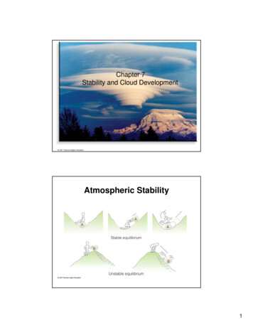
Chapter 7Stability and Cloud DevelopmentAtmospheric Stability1
Cloud Development - stable environment Stable air (parcel) - vertical motion is inhibited– if clouds form, they will be shallow, layered clouds likestratus Cloud Development - unstable environment– Unstable air (parcel) - vertical motion occurs– commonly produces cumulus, cumulonimbus cloudsHow to determine atmospheric Stability? A ball in water:– When does it rise?– When does it sink? An air parcel:– Density– Lighter than environment, it will rise.– Heavier than environment, it will sink. What determine air density at a givenpressure:– Temperature2
Determining Air Parcel Temperature: Risingair parcels and adiabatic cooling consider a rising parcel ofair -- As the parcel rises, it willadiabatically expand andcool adiabatic - a processwhere the parceltemperature changes dueto an expansion orcompression, no heat isadded or taken awayfrom the parcelConsider a sinking parcel of air -- Adiabatic lapse rate As a parcel of air rises, it cools, but at what rate? Lapse rate– rate of temperature change with height– units of lapse rate are C km-1 Dry-adiabatic lapse rate– unsaturated parcels cool at a rate of 10 C km-1 - this iscalled the dry-adiabatic lapse rate Moist Adiabatic Lapse Rate– For a saturated parcel of air, i.e., when its T Td, then itcools at the moist adiabatic lapse rate 6 C km-1 Q: Why does the parcel cool at a slower rate (6 Ckm-1) when it is saturated than at 10 C km-1 when itis unsaturated?3
Dry versus Moist-Adiabatic Process the moist adiabatic lapse rate is less than the dryadiabatic lapse rate because as vaporcondenses into water (or water freezes into ice)for a saturated parcel, latent heat is releasedinto the parcel, mitigating the adiabatic coolingMoist adiabatic lapse rate: vary with temperature andpressure4
Assessing Atmospheric Stability The bottom line – To determine whether or not a parcel will rise or sinkin the atmosphere, one must compare the parcelstemperature (Tp) with that of the environment (Te) atsome altitude:– if Tp Te what will the parcel do?– if Tp Te what will the parcel do?– if Tp Te what will the parcel do? So, to assess stability, what two pieces ofinformation do we need?Absolute Stability Generally, notice that Te is always larger than Tsp and Tup at any level– Hence, an unsaturated or saturated parcel will always be cooler than theenvironment and will sink back down to the ground The condition for absolute stability is:––––Γd Γm ΓeΓd is the dry adiabatic lapse rate (10 C km-1)Γm is the moist adiabatic lapse rate (6 C km-1)Γe is the environmental lapse rateTup: thetemperature of anunsaturated parcelTsp: temperature ofa saturated parcelTe: environmentaltemperature5
Stability of Inversion Layers Q: How would you characterize the stability of aninversion layer?– They are absolutely stable Note that the absolute stability criteria: Γe Γm Γd Q: How do you formstable layers in theatmosphere?– Radiational Cooling radiation inversion– cold air moving in at lowlevels– warm air moving over coldgroundCold surface air, on this morning, produces a stableatmosphere that inhibits vertical air motions and allowsthe fog and haze to linger close to the ground.6
Formation of Subsidence Inversions How does the stability change for adescending layer of air?The top of the layer warmsmore than the bottomNatural Stability The environmental lapse rate is equal tothe dry adiabatic rate. Or when parcel is saturate: 7
Absolute Instability The condition for absolute instability is:– Γe Γd Γm Hence, an unsaturated or saturated parcel will always bewarmer than the environment and will continue to ascendConditional Instability The condition for conditional instability is:– Γd Γe Γm The unsaturated parcel will be cooler than then environmentand will sink back to the ground The saturated parcel will be warmer than the environment andwill continue to ascend8
Stability of the environment To determine the environmental stability, one must calculatethe lapse rate for a sounding lapse rate -DT/DZ (T2-T1)/(Z2-Z1) Since the environment is often composed of layers withdifferent stabilities, it is useful to first identify these layersand then calculate their respective lapse rates recall the stability criteria:– Γe Γm - Absolutely stable– Γm Γe Γd - ConditionalInstability– Γm Γd Γe - AbsolutelyunstableProcesses that destabilize the atmosphere1. By cooling of the air aloft and Warming of the surface airCooling of the air aloft– Cold air moving is aloft this often occurs when an extra tropical cyclone passesoverhead– Clouds or air emitting IR radiation to spaceWarming of the surface air– Surface Heating - suggests thatthe atmosphere will be mostunstable. When?– Warm air moving in at low levels this often occurs ahead of acold front– Cold air moving over a warmsurface: Such as lake effect snow9
The warmth from the forestfire heats the air, causinginstability near the surface.Warm, less-dense air (andsmoke) bubbles upward,expanding and cooling as itrises. Eventually the risingair cools to its dew point,condensation begins, anda cumulus cloud forms.2. Destabilize the atmosphere by mixingCooling the top layerWarming the bottom layer10
3. Destabilize the atmosphere by liftingThe vertical stretch of the unsaturated layer cools the topof the layer more than the bottom—conditionally unstable.3. Destabilize the atmosphere by liftingThe vertical stretchof a bottomsaturated and topunsaturated layercools the top of thelayer more thanthe bottom—absolutelyunstable.Convective instability11
Atmospheric Instability and CloudDevelopment1.How are vertical parcel motions that create clouds generatednaturally in the atmosphere?––––Surface heating and free convectionTopographyWidespread ascent due to convergence of surface airUplift along weather frontsAtmospheric Instability and CloudDevelopment - lifting mechanisms2. What kind (if any) clouds will you visually observe indifferent stable environments?In an absolutely stable environment, no clouds will likely form.In a shallow conditionally unstable or absolutely unstableenvironment, one may expect clouds to develop, but theirvertical growth will be limited, and may observe:cumulus humilis (shallow cumulus)stratocumulusIn a deep conditionally unstable or absolutely unstableenvironment, one may expect clouds to develop withsignificant vertical development, and may observe:cumulus congestuscumulonimbus12
Cloud Development - Convection Convection usually occurs when the surface is heated and asurface parcel becomes warmer than the environment -- the vertical extent of the cloud is largely determined by thestability of the environment.Cumulus clouds form ashot, invisible air bubblesdetach themselves from thesurface, then rise and coolto the condensation level.Below and within thecumulus clouds, the air isrising. Around the cloud, theair is sinking.The development of a cumulus cloudLayer A: Absolutely unstableLayer B or C: Absolutely stableLayer A and B on average: conditional unstabletopCloud base Height13
Cumulus clouds building ona warm summer afternoon.Each cloud represents aregion where thermals arerising from the surface. Theclear areas between theclouds are regions wherethe air is sinking.The air’s stability greatlyinfluences the growth ofcumulus cloudscumulonimbusCumulus cloudsdeveloping intothunderstorms in aconditionally unstableatmosphere over theGreat Plains. Noticethat, in the distance, thecumulonimbus with theanvil top has reachedthe stable part of theatmosphere.Cumulus Congestus14
What determines cumulus cloud bases height?Cloud Development - Topographic Lifting Simply, air is forced up and over a topographical barrier such as a hill or mountain The windward side will be cloudy and wet as air ascends The leeward side will be warmer and drier as the airdescends - often called a rain shadow15
Topographic Lifting - Wave Clouds If air being forced over a topographical barrier isstable, then wave clouds often form Lenticular clouds are an example Wave clouds are often aligned in "waves" and areoften visible in satellite imagery.Satellite view of waveclouds forming manykilometers downwind ofthe mountains in Scotlandand Ireland.16
The mixing of a moist layer of air near the surfacecan produce a deck of stratocumulus cloudsCold air move over warmsurfaceStratocumulus clouds formingin rows over the Atlantic oceanas cold, dry arctic air sweepsover CanadaCloud Development - Convergence if air converges to a given location near the surface:– it can't "pile up" at that point– it can't go downward, the ground is there– it must go up! common at the center of an extra-tropical cyclone17
Cloud Development - Frontal Lifting If air is lifted into a stable layer:– stratus or nimbostratus clouds are often the result (common alongwarm fronts) if air is lifted into a conditionally unstable layer:– cumulus or cumulonimbus are often the result (common along coldfronts)Billow clouds forming in a region of rapidly changing windspeed, called wind shear.Wind shear18
2 Cloud Development - stable environment Stable air (parcel) - vertical motion is inhibited - if clouds form, they will be shallow, layered clouds like stratus Cloud Development - unstable environment - Unstable air (parcel) - vertical motion occurs - commonly produces cumulus, cumulonimbus clouds