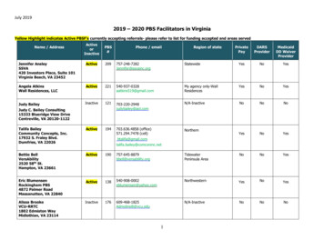
Transcription
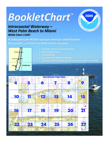
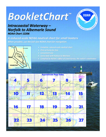
BookletChart Intracoastal Waterway –Norfolk to Albemarle SoundNOAA Chart 12206A reduced-scale NOAA nautical chart for small boatersWhen possible, use the full-size NOAA chart for navigation.
Published by theNational Oceanic and Atmospheric AdministrationNational Ocean ServiceOffice of Coast Surveywww.NauticalCharts.NOAA.gov888-990-NOAAWhat are Nautical Charts?Nautical charts are a fundamental tool of marine navigation. They showwater depths, obstructions, buoys, other aids to navigation, and muchmore. The information is shown in a way that promotes safe andefficient navigation. Chart carriage is mandatory on the commercialships that carry America’s commerce. They are also used on every Navyand Coast Guard ship, fishing and passenger vessels, and are widelycarried by recreational boaters.What is a BookletChart ?This BookletChart is made to help recreational boaters locatethemselves on the water. It has been reduced in scale for convenience,but otherwise contains all the information of the full-scale nauticalchart. The bar scales have also been reduced, and are accurate whenused to measure distances in this BookletChart. See the Note at thebottom of page 5 for the reduction in scale applied to this chart.Whenever possible, use the official, full scale NOAA nautical chart fornavigation. Nautical chart sales agents are listed on the Internet athttp://www.NauticalCharts.NOAA.gov.This BookletChart does NOT fulfill chart carriage requirements forregulated commercial vessels under Titles 33 and 44 of the Code ofFederal Regulations.Notice to Mariners Correction StatusThis BookletChart has been updated for chart corrections published inthe U.S. Coast Guard Local Notice to Mariners, the National GeospatialIntelligence Agency Weekly Notice to Mariners, and, where applicable,the Canadian Coast Guard Notice to Mariners. Additional chartcorrections have been made by NOAA in advance of their publication ina Notice to Mariners. The last Notices to Mariners applied to this chartare listed in the Note at the bottom of page 7. Coast Pilot excerpts arenot being corrected.For latest Coast Pilot excerpt visit the Office of Coast Survey website hart.php?chart 12206(Selected Excerpts from Coast Pilot)Albemarle Sound is about 45 miles long inan east-west direction, and in width rangesfrom 11 miles near its eastern end to 3miles about 10 miles from the western end.The sound has good navigable depths topass through the canals and, with itstributaries, forms the approach to manytowns and landings. Albemarle SoundHerring Management Area, a MarineProtected Area (MPA), includes Albemarle,Currituck, Roanoke and Croatan Sounds.There are depths of 10 to 18 feet along the routes from North River andPasquotank River to Croatan Sound and Alligator River, and less waterfarther eastward. Fish stakes and nets, extending long distances fromshore are often found on the shoals, especially at the northern entranceto Croatan Sound. The shores of Albemarle Sound are low and generallywooded; there are no prominent natural features.A naval aircraft bombardment target area is on the south side ofAlbemarle Sound westward of the entrance to Alligator River. (See334.410, chapter 2, for limits and regulations.)The eastern end of Albemarle Sound, which is separated from theAtlantic Ocean by the barrier beach about 15 miles north of Bodie IslandLight, is connected northward with Currituck Sound and southward withCroatan and Roanoke Sounds, and by the latter sounds with PamlicoSound.Westward of Laurel Point, about 33 miles from the east end ofAlbemarle Sound, the water is usually fresh or slightly brackish. The riseand fall of the water level depends on the direction of the winds.Pasquotank River Entrance Light PR (36 09'23"N., 75 58'38"W.), 23 feetabove the water, shown from a multi-pile structure with a black andwhite diamond-shaped daymark, marks entrance to Pasquotank River. Alight is about 2.2 miles westward of the entrance light. The river,entered between Wade Point on the west and Camden Point on theeast, and Elizabeth City are described in connection with the DismalSwamp Route of the Intracoastal Waterway, chapter 12.Norfolk, on the east bank of the Elizabeth River in Norfolk Harbor 26miles inside the entrance to Chesapeake Bay, is one of the major portsof the United States. Supply and repair facilities are available at themarinas and yacht basins in Norfolk Harbor. A detailed description of theport is contained in United States Coast Pilot 3, Atlantic Coast, SandyHook to Cape Henry.From the City Wharf at the foot of West Main Street in Norfolk, Mile0.0, the Intracoastal Waterway follows the Southern Branch of ElizabethRiver to its junction with Deep Creek where the waterway divides intotwo routes. Naval restricted areas are on both sides of the river. (See334.290, chapter 2, for limits and regulations.)The speed limit is 6 knots from Eastern Branch to the railroadbridge, Mile 2.6. This bridge has a lift span with a clearance of 6 feetdown and 142 feet up. VHF-FM channels 16 and 13 are monitored at thebridge. At Mile 2.8, Jordan (State Route 337) highway bridge has a liftspan with a clearance of 15 feet down and 145 feet up. VHF-FMchannels 16 and 13 are monitored at the bridge. The railroad bridgeat Mile 3.6 has a lift span with a clearance of 10 feet down and 135 feetup. U.S. Routes 460 and 13 highway bridge and the Norfolk SouthernRailway bridge at Mile 5.8 have bascule spans with clearances of 11 feetand 7 feet, respectively; large vessels must exercise caution whenmaking the turns to these bridges because of the current. VHF-FMchannels 16 and 13 are monitored at these bridges. An overhead powercable at Mile 6.5has a clearance of 152 feet, and two overhead cablesat Mile 6.9 have clearances of 161 feet. Interstate Highway Route 64bascule bridge at Mile 7.1 has a clearance of 65 feet. (See 117.1 through117.59 and 117.997 (a) through (e), chapter 2, for drawbridgeregulations.) The bridgetender may be contacted at 757-545-4685.The Albemarle and Chesapeake Canal, about 10 miles long, connectsSouthern Branch of Elizabeth River with North Landing River.Great Bridge, a town on the Albemarle and Chesapeake Canal at Mile12.0, has bus connections with Norfolk. State Route 168 highway bridgeacross the canal at the town has a double-leaf bascule span with aclearance of 8 feet. VHF-FM channels 16 and 13 are monitored at thebridge. (See 117.1 through 117.59 and 117.997 (e), chapter 2, fordrawbridge regulations.)U.S. Coast Guard Rescue Coordination Center24 hour Regional Contact for EmergenciesRCC Miami2Commander7th CG DistrictMiami, FL(305) 415-6800
Lateral System As Seen Entering From Seawardon navigable waters except Western RiversPORT SIDEODD NUMBERED AIDSGREEN LIGHT ONLYFLASHING (2)FLASHINGOCCULTINGQUICK FLASHINGISOPREFERRED CHANNELNO NUMBERS – MAY BE LETTEREDPREFERRED CHANNELNO NUMBERS – MAY BE LETTEREDPREFERRED CHANNEL TOSTARBOARDTOPMOST BAND GREENPREFERRED CHANNELTO PORTTOPMOST BAND REDGREEN LIGHT ONLYRED LIGHT ONLYFLASHING (2)FLASHINGOCCULTINGQUICK FLASHINGISORED LIGHT ONLYCOMPOSITE GROUP FLASHING (2 1)COMPOSITE GROUP FLASHING (2 1)812"1"Fl G 6sLIGHTGR "A"Fl (2 1) G 6sG "9"Fl G 4s5DAYBEACON"2"Fl R 6sRG "B"Fl (2 1) R 6sG"5"UCGR"U"RGN "C"GRC "S"CANG6RG"G"NUNFor more information on aids to navigation, including those on Western Rivers, please consult the latest USCG Light List for your area.These volumes are available online at http://www.navcen.uscg.govRN "6"NUNR "8"Fl R 4sLIGHTED BUOYLIGHTLIGHTED BUOYGC "1"CANSTARBOARD SIDEEVEN NUMBERED AIDS2DAYBEACONR"2"
VHF Marine Radio channels for use on thewaterways:Channel 6 – Inter-ship safety communications.Channel 9 – Communications between boats andship-to-coast.Channel 13 – Navigation purposes at bridges, locks, andharbors.EMERGENCY INFORMATIONChannel 16 – Emergency, distress and safety calls toCoast Guard and others, and to initiate calls to othervessels. Contact the other vessel, agree to another channel, and then switch.Channel 22A – Calls between the Coast Guard and the public. Severe weatherwarnings, hazards to navigation and safety warnings are broadcast here.Channels 68, 69, 71, 72 and 78A – Recreational boat channels.Distress Call Procedures Make sure radio is on. Select Channel 16. Press/Hold the transmit button. Clearly say: “MAYDAY, MAYDAY, MAYDAY.” Also give: Vessel Name and/or Description;Position and/or Location; Nature ofEmergency; Number of People on Board. Release transmit button. Wait for 10 seconds — If no responseRepeat MAYDAY call.Getting and Giving Help — Signal other boaters using visual distress signals (flares,orange flag, lights, arm signals); whistles; horns; and on your VHF radio. You arerequired by law to help boaters in trouble. Respond to distress signals, but do notendanger yourself.HAVE ALL PERSONS PUT ON LIFE JACKETS!NOAA Weather Radio All Hazards (NWR) is a nationwide network of radio stations broadcasting continuousweather information directly from the nearest National Weather Service office. NWR broadcasts official WeatherService warnings, watches, forecasts and other hazard information 24 hours a day, 7 days a week.http://www.nws.noaa.gov/nwr/Quick ReferencesNautical chart related products and information - http://www.nauticalcharts.noaa.govQRInteractive chart catalog - .shtmlReport a chart discrepancy - hart and chart related inquiries and comments - page ContactUsChart updates (LNM and NM corrections) - http://www.nauticalcharts.noaa.gov/mcd/updates/LNM NM.htmlCoast Pilot online - htmTides and Currents - http://tidesandcurrents.noaa.govMarine Forecasts - http://www.nws.noaa.gov/om/marine/home.htmNational Data Buoy Center - http://www.ndbc.noaa.gov/NowCoast web portal for coastal conditions - http://www.nowcoast.noaa.gov/National Weather Service - http://www.weather.gov/National Hurrican Center - http://www.nhc.noaa.gov/Pacific Tsunami Warning Center - http://ptwc.weather.gov/Contact Us - tmFor the latest news from Coast Survey, follow @NOAAchartsThis Booklet chart has been designed for duplex printing (printed on front and back of one sheet). If a duplex optionis not available on your printer, you may print each sheet and arrange them back-to-back to allow for the properlayout when viewing.NOAA’s Office of Coast SurveyThe Nation’s Chartmaker
cable at Mile 6.5 has a clearance of 152 feet, and two overhead cables at Mile 6.9 have clearances of 161 feet. Interstate Highway Route 64 bascule bridge at Mile 7.1 has a clearance of 65 feet. (See 117.1 through 117.59 and 117.997 (a) through (e) , chapter 2, for drawbridge regulations.) The bridgetender may be conta cted at 757 -545- 4685.