Transcription
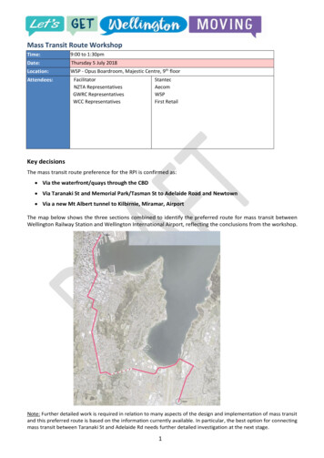
Mass Transit Route WorkshopTime:9:00 to 1:30pmDate:Thursday 5 July 2018Location:WSP - Opus Boardroom, Majestic Centre, 9th floorAttendees:FacilitatorNZTA RepresentativesGWRC RepresentativesWCC RepresentativesStantecAecomWSPFirst RetailKey decisionsThe mass transit route preference for the RPI is confirmed as: Via the waterfront/quays through the CBD Via Taranaki St and Memorial Park/Tasman St to Adelaide Road and Newtown Via a new Mt Albert tunnel to Kilbirnie, Miramar, AirportThe map below shows the three sections combined to identify the preferred route for mass transit betweenWellington Railway Station and Wellington International Airport, reflecting the conclusions from the workshop.Note: Further detailed work is required in relation to many aspects of the design and implementation of mass transitand this preferred route is based on the information currently available. In particular, the best option for connectingmass transit between Taranaki St and Adelaide Rd needs further detailed investigation at the next stage.1
Introduction Purpose of the workshop: to undertake a structured evaluation of mass transit route options through thecentral city, to determine a preference for evaluation in the Recommended Programme of Investment(RPI). Background and context presented to the workshop. Specialist advice on light rail (SN), network planning (HS), land value uplift (AK), engineering (GD) andretail impacts (CW) was provided as an input to the workshop discussion. For the purposes of this route assessment, the mass transit mode was assumed to be either light rail (LRT)or like light rail (LLRT). Costs were estimated for LRT as the most expensive case, LLRT likely to involvelesser costs, but the relativity between route options would be similar. Key mass transit characteristics sought included: High frequency (10 minutes or better); modern, highcapacity (e.g. articulated) electric vehicles, with superior ride quality; dedicated lanes with signal priority;fast loading and unloading at high quality stations with level boarding. The evaluation of route options for mass transit were considered in three parts:1. Wellington station to Te Aro2. Te Aro to Newtown3. Mass transit to the airport/eastDiscussion Role of mass transit: The need to be clear about the role of mass transit was acknowledged. The role wasagreed as being both access to destinations in the CBD and faster journeys for longer regional trips. Theneed to balance these roles was taken forward to the evaluation. Minimum operable section: Mass transit from Wellington station to south Newtown/Zoo is considered tobe a minimum operable section. It is likely to be most feasible to deliver, not without considerablechallenges, and is recommended as a first stage. Beyond this section the costs, risks and challenges increasesignificantly due to the landscape and geometry and need for a tunnel. The issue of 90% effort for 10%benefits was highlighted. Gradients: The recommended maximum design gradient for LRT is 7%, with short sections possible at asteeper grade of round 8.5% (200 metres max). Wireless operation may limit options for steeper gradesfurther. These are guides only, and most important advice is to avoid designing anywhere near the‘maximum’ gradients at this early stage. Transfers: The level of transfers was highlighted as a key issue influencing the number of vehicles on themass transit route, and vehicle numbers on the CBD spines. An LRT mass transit solution would add a newmode and create additional transfers. Public acceptability of transfers has been challenging to date and anetwork design forcing too much transfer may affect overall public transport use. It was acknowledged thatpeople may become more accepting of transfers over time, but the critical factor would be the level ofbenefit from a transfer. People are less likely to mind transferring if a much better journey is provided thanthe no-transfer alternative. Conversely, people do not like transferring if the journey is similar to or worsethan the non-transfer journey. Urban development in the east: The potential for significant growth and redevelopment in Miramar wasnoted. The need to look at this further through the next stage of work to assess urban developmentpotential associated with mass transit. Retail impacts: The fragility of retail along Wellington’s Golden Mile was noted. Having mass transit on analternative route and spreading retail concentration beyond the Golden Mile was not considered to besignificant risk. It was thought likely that large corporate retailers would want to stay on the Golden Mile the premium shopping street - and that new businesses, particularly hospitality, may move in to takeadvantage of increased pedestrian activity to/from the mass transit route. The biggest risk was seen as theimpact of short-medium term disruption if mass transit were to be constructed along the Golden Mile. Thiscould exacerbate the current retail fragility to the extent that large corporate retailers may leave altogether.The following sections of this report outline the different route options considered in the workshop and therationale for selecting the preferred route.2
1. Wellington Railway Station to Te Aro (through the CBD)Options considered: Golden Mile (Red)Waterfront/Quays (Blue)Featherston and Victoria (Yellow)Preferred routes identified for RPI: Waterfront/Quays for LRT/LLRTNote: Golden Mile was identified as preferred secondCBD PT spineRationale for selection of preferred route: Significant urban regeneration opportunities – anumber of key sites identified Attracts urban activation and pedestrianmovement beyond the Golden Mile Slightly faster travel speeds and a straighter,more direct route Improved connections to the waterfront Better resilience following a seismic event due to less risk from fallen buildings/debris Easier to build due to width of corridor and ability for partial-only closure; less impact on existing busservices and existing retailers. Quicker construction time, may save on disruption and some cost.Note: While the 800m walking catchment for this route covers most destinations through the CBD, this doesnot mean that increased walking distance is not an important factor. A strategy is needed to providehigh quality pedestrian connectivity between the waterfront and the Terrace, to maximise the walkingcatchment for this route. Placement of LRT/LLRT in the waterfront/quays corridor needs further consideration as it impacts:pedestrian crossing infrastructure/ease/safety; resilience from falling buildings (post regeneration). Evaluation assumed there would continue to be significant bus numbers on the second spine. Numberswill depend on network design and the level of transfers to LRT/LLRT. Need to confirm bus numbersunder an optimised LRT/LLRT network.Why not Featherston St/Victoria St? Would have a significant impact on local traffic circulation (the function of this route within the one-waysystem was considered) Provides an important role for general traffic access to the CBD for deliveries/servicing, and vehicleaccess to key sites like Police headquarters Greater degree of side friction from side roads and vehicle crossings, which could affect priority andreliability of the mass transit corridor Has more challenging corners and geometry; more property impacts and risk of noise from tightcornering Has the most impact on on-street parking.3
2. Te Aro to NewtownOptions considered: Taranaki Street, with a connection to Adelaide Rd Suboptions:a. Memorial Park /Tasman (Red)b. Tunnel Taranaki to Adelaide (Yellow)c. Massey link (Blue)via Kent/Cambridge Terrace, Basin Reserve, AdelaideRd (Green)Preferred route identified for RPI: Taranaki Street with an ‘at grade’ connection to AdelaideRoad via Memorial Park/TasmanRationale for selection of preferred route: Significant urban redevelopment potential due to its central location in the Te Aro precinct and becauseit covers more of Adelaide Road from the Basin Reserve south. Good walking catchment. Avoids conflict with SH1 at Taranaki St and provides better access to schools at the Basin than otherTaranaki Street options. Better connection with the waterfront/quays option and best interchange arrangement with the secondCBD spine. More resilient route with less flood risk and located on a strategic corridor (Taranaki St) identified forwider resilience investment. Likely to cost the least and be easiest to deliver.Notes: All Taranaki Street options were considered to be equally better overall compared with theKent/Cambridge option in relation to: urban redevelopment potential; walking catchment; and,resilience. Amenity benefits (enhanced street environment associated with LRT/LLRT) that could influence urbanregeneration were assumed along the corridor itself, not just around the station. All Taranaki options were noted to involve bus service duplication and to create some awkward networkdesign issues. These network issues were not considered to outweigh the other benefits of a Taranaki Stalignment. The preferred route has more corners than other options, but the built environment in this area wasconsidered to provide some flexibility for corner easing. Deliverability of the preferred route also has some challenges around potential impact on Mt CookSchool and a steep gradient for a short section. These negatives were not considered to outweigh otherbenefits of the option. A potential development partnership opportunity as part of Massey option (blue route) was discussed,alongside the significant property impact to trench for LRT/LLRT. An option that placed mass transit in a north-south tunnel under the Basin was suggested as a straight,direct option that had travel speed advantages. Could be considered further, but major impact oframping down to a tunnel and underground stream presence noted.4
3. Mass transit to the eastOptions considered: Extend from Newtown/Zoo via Mt Alberttunnel to the east (Green) Via Constable St/Crawford Rd to the east(Yellow) New branch from Basin Reserve to the east(Red)Preferred routes identified for RPI: Extend from Newtown/Zoo via Mt AlberttunnelRationale for choosing preferred route: Extending stage 1 of the mass transitcorridor to the east via a new Mt Albert tunnel is likely to be much more cost effective at approximately 450M compared to 630M for a second branch via Mt Victoria, which has the cost of the duplicated MtVictoria tunnel and 4-laning of Ruahine Street removed from the equation. The Mt Albert option was also considered to be more feasible, despite land requirements for tunnelportals, because gradient issues were expected to be less significant than those between the BasinReserve and Mt Victoria Tunnel.Note: Constable St/Crawford Rd were ruled out at the beginning and not evaluated. Previous work hadidentified significant property and parking impacts, together with gradient and curvature issues thatwere considered a fatal flaw for LRT/LLRT. When evaluating the two remaining options, the first stage of mass transit from the railway station tosouthern Newtown/Zoo was assumed as a given. A direct comparison was therefore difficult as theoptions did not start and end in the same place. The assumption around the first stage to Newtown was tested by asking whether the LRT/LLRT routeoption via Mt Victoria would stand up on its own. It was considered unlikely given the limited urbanregeneration potential through this part of the corridor compared with Newtown. So the question forevaluation was confirmed as: extend via a single spine from Newtown; or, extend to the east with a newbranch from the Basin. The route option via Mt Victoria Tunnel and Ruahine Street was acknowledged to be slightly shorter andmore direct, and with less side friction. Journeys from the airport/Miramar were therefore likely to bearound 2-3 minutes quicker via this route, however this was not considered to outweigh cost anddeliverability factors. Under a future with LRT/LLRT to the east via Mt Albert, there are still likely to be express buses and localbuses via Hataitai/Mt Victoria bus tunnel.5
mass transit route, and vehicle numbers on the CBD spines. An LRT mass transit solution would add a new mode and create additional transfers. Public acceptability of transfers has been challenging to date and a network design forcing too much transfer may affect overall public transport use. It was acknowledged that


![Index [beckassets.blob.core.windows ]](/img/66/30639857-1119689333-14.jpg)