Transcription
2/9/17UAS PlatformsA White Paper prepared forNCAR / EOL Workshop - Unmanned Aircraft Systems for Atmospheric Research –February 20171.0 Lead author and contributing authorsMatt Fladeland, NASA Ames Research CenterSusan Schoenung, Bay Area Environmental Research InstituteMark Lord, NCAR2.0 Executive summaryMany atmospheric science investigations that typically use manned aircraft can beclassified as dull, dirty, or dangerous. UAS platforms are uniquely suited for these typesof missions. Numerous small UAS and several large UAS have been used successfully bygovernment agencies and academia for scientific research. No single class or type ofUAS can satisfy all anticipated mission scenarios. This whitepaper provides an overviewof the different classes of UAS and their capabilities along with some recommendationsfor implementation of this technology for scientific pursuits.3.0 Outline of the topic1.2.3.4.5.UAS ClassificationsPast UAS activities / platforms used for Atmospheric ResearchAvailable UAS and their performance specificationsNotes regarding trade-offs between altitude, endurance and payloadData handling and telemetry3.1 UAS ClassificationUAS can be categorized in a variety of ways based on vehicle attributes including thetype of aircraft (fixed wing or rotorcraft), flight altitude (high, medium, low), weight,speed, etc. In general, larger aircraft use larger engines that confer higher altitude, longerendurance and more payload capacity than smaller vehicles. Cost of maintenance andoperations and consequently research budgets also scales with size.Different organizations (NATO, DoD, NASA, State Regulatory Authority) each havedefined groups or classes of UAS. Most of these classifications are based on weight andaltitude or speed. While classification group nomenclature differs among these1
2/9/17organizations, some specific weight limits are commonly used. The typical weight limitsfor different classes of vehicles are 25 kg (55 lbs), 150 kg (330 lbs), and 600 kg (1320lbs).The Federal Aviation Administration (FAA) has initially provided regulations (14 CFRPart 107) for “small UAS” operations for vehicles under 55 pounds [1]. Additionalrestrictions include maximum speed of 87 knots and maximum altitude of 400 feet. The55-pound weight limit has been historically used to define model aircraft in the U.S.Based on FAA interaction with other organizations concerning integration of UAS in theNational Airspace System, we could expect future FAA regulations to consider vehicleclasses with weights from 55 to 330 pounds, 330 to 1320 pounds, and greater than 1320pounds. Again this would historically relate directly to current ultralight, light sportaircraft, and normal/utility and transport category aircraft and rotorcraft respectively.DoD subdivides vehicles weighing more than 1320 pounds into two groups basedmaximum altitude [2]. FAA may eventually add additional classes based on a 12,500pound weight. This would enable promulgation of airworthiness and operationalstandards for normal ( 12,500 lbs) and transport ( 12,500 lbs) category aircraft androtorcraft to UAS. A representative classification matrix is shown below in Table 1. TheNASA classification matrix, shown in Table 2, includes both weight the airspeedlimitations for three categories of UAS [3]. In addition, NASA specifies requirements forthe UAS Pilot and Observer.Table 1. Representative UAS ClassificationWeightkg 22 - 2525 - 150150 - 600NormalOperatingAltitude, ft 400 3000 5000 hrs 12-84 - 128 - 14 600 600 18,000 18,00010005000 20 24Representative PlatformsBlack Widow, RavenAerosonde, Scan Eagle, PumaManta BSIERRA, Viking 400,TigerSharkIkhana (Predator B)Global HawkTable 2. NASA UAS Classification MatrixCategoryWeightAirspeed (kt)TypeI 55 lb (25 kg) 70Model or sUASII55-330 lb (25-150 kg) 200sUAS2III 330 lb (150 kg) 200UAS
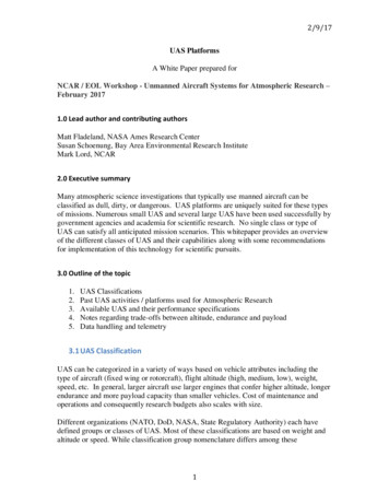
2/9/173.2 Past UAS activities / platforms used for Atmospheric ResearchUAS have been utilized in many science missions, going all the way back to 1993. Someof these missions have targeted imagery (fire, vegetation) and surface measurements, butmany have been applied to atmospheric research, both physical (dynamics, weather, etc.)and chemical (e.g., composition). The timeline in Figure 1 shows early NASA UASmissions. The information in Table 2 provides more information about a selection ofatmospheric research activities.Figure 1. Early UAV timelineTable 2. Representative UAS MissionsMissionAltus Cumulus Experiment(ACE)ARM-UAVAerosonde HurricanemissionMaldives (vertical stack)GloPacGRIPWestern States FireCASIEMIZOPEXSO2 samplingATTREXHS3SHOUTAgencyNASA 0022005GnatAerosondeScrippsNASA /NOAANASA /NOAANASANASANASA /NOAANASA / JPLNASANASANOAARamanathan 20082010Mantas (3)Global Hawk2010Global Jensen20142011 -20142012-20142015-2016Altair, IkhanaSIERRASIERRA, ScanEagle, DataHawkDragonEyeGlobal HawkGlobal HawkGlobal HawkHood3UAS
2/9/17Multiple Manta UAS participated in the Maldives AUAV Campaign (MAC) to observeAerosol-Cloud-Radiation-Climate Interactions (Scripps, 2006)SIERRA UAS during Characterization of Arctic Sea Ice Experiment (CASIE) withLIDAR and C-band SAR (NASA, 2009)Global Hawk flew from Wallops Flight Facility for the Sensing Hazards with OperationalUnmanned Technology (SHOUT) mission to track Atlantic Hurricanes (NOAA, 2015and 2016)4
2/9/17The Airborne Tropical TRopopause Experiment sampled profiles over the Pacific (2013,2014, NASA)5
2/9/173.3 Available UAS and their performance specificationsMost of the commercially available “drones” are multi-rotor aircraft designed for shortdistance and short duration flight. For the most part, they fall into the FAA “small UAS”(sUAS) category, are limited in payload weight and altitude, and are often restricted toflight within line-of-sight of the operator. US government agencies that have beeninvolved in using UAS for science experiments either own their own aircraft or contractwith vendors for flight activities. For the most part, government agencies own andoperate only a few of their own UAS. Table 3 shows a representative list of agencyowned UAS. Table 4 shows some of their performance specifications. Table 5 lists someof the UAS available from industry that may be useful for science.Table 3 Representative Agency UAS aircraftAgencyNASAJPLDOENOAANRLUniv. Alaska FairbanksUniv. ColoradoUAS owned and operatedSIERRA, VIKING400, DragonEye, Ikhana, Global Hawk3DR Solo, 3DR X-8, DJI S1000, QAV 400, Infinity-6Arctic Shark (variant of TigerShark); CU DatahawkScan EagleIon Tiger – 48 hours, 5 lbScan EagleCU Datahawk, Tempest UASTable 4. Agency UAS eSIERRAViking 400TigerSharkIkhana(Predator B)Global HawkMax Altitude, ft4001000100019,50012,00025,00015,00045,000Max flight duration, hr1.51482410111020Max payload, lb715EOIR sensors included100100100200065,0002618006
2/9/17Table 5 Commercial UAS suitable for atmospheric scienceVendorDJI3DRSwift EngineeringLockheed Martin/MLBBoeing / InSituAircraft nameMatrice 600, S-900, S-1000IRIS, X-8020VBATNotesEPA plume samplingQuadcopter with aerial cameraVertical take-off, level flightLong enduranceScanEagleVery long endurance, swappablepayloadFAA Experimental AirworthinessCertificate, multiple payloadcapabilityOperated at Alaska test rangeVery long endurance, heavy fuelAAI Corp / TextronShadow 200 TAUSGriffin AerospaceVanilla AircraftOutlaw Sea HunterVA0013.4 Trade-offsUAS are frequently advertised by their payload capability, flight duration, ormaximum altitude. It is important to note that an aircraft can often not achievemaximum performance of all these parameters at one time. A trade-off betweenpayload weight and flight duration may be made to exchange fuel, and hence flighttime, for payload carrying capacity, for example.Payload is proportional to vehicle gross weight as shown in the following Figure ross Weight, lbsFigure 2. Payload weight for representative UAVs listed in Table 1.7
2/9/17Another trade-off is between cost (or complexity) and payload capacity. Figure 3.shows the payload capacity for several small and mid-size UAS. Very large UAS, likeGlobal Hawk and Ikhana can carry up to 2000 lbs payload, but these are large,expensive aircraft. System cost can be difficult to compare directly due to systemcomplexity, various payload options, and even the number of air vehicles andground stations comprising a complete system. Figure 4 shows typical singlevehicle cost and payload capacity ranges for current DoD UAS groups Note thelogarithmic scale.Payload weight for small-medium UAS10080lb6040200Figure 3. Payload weight (lb) for some small and mid-size UAS8
2/9/171000100UAV Cost, M5 (HALE)104 (MALE)13 (TUAS)2 (sTUAS)0.11 (Mini)0.010.1110100100010000Payload, lbsFigure 4. Vehicle Cost and payload capacity ranges for DoD UAV Groups (compiledfrom various public domain sources).3.5 Data Handling and TelemetryAn important consideration when selecting aircraft for science observations is the degreeto which the payload is either independent or dependent on aircraft power andcommunications. For sUAS it is often the case that the payload is entirely independentfrom the power and communications in order to conserve battery power and telemetrybandwidth. Aircraft position and navigation data is then downloaded from the aircraft orground station after the flight to support data processing and interpretation. Largeraircraft will often provide power and either line of site telemetry or SATCOMconnectivity via the autopilot or an independent radio or modem. Realtime data from thepayload enables controllers to ensure that the instrument is operating as expected andcollecting data. Ideally information on the aircraft and payloads are displayed into ageographic information system of some kind which enables integration of other data setsthat can aid in interpretation of the data as well as assisting controllers in ensuring thatflight plans can be updated as conditions change. As and example, the NASA MissionTools Suite (www.mts.nasa.gov) is a common operating picture used for all NASAscience aircraft enabling missions participants to track aircraft position on a moving mapsdisplay, view data quick-looks, and overlay thousands of different satellite and grounddata sets.9
2/9/17Figure 5: A Screenshot of the NASA Airborne Science Program Mission Tools Suite thatenables realtime tracking of aircraft position as well as information on payload status anddata quicklooks.4.0 PerspectiveOffer perspective on the topic area (why important, key challenges, major opportunities,limitations and/or constraints on progress, etc.)Opportunities for UAS to perform atmospheric research abound because they can flywhere manned aircraft cannot or do not, for safety reasons. In principle, they can fly verylong duration, thus sampling atmospheric parameters over a diurnal cycle, for example.They can fly very high, if desired, or loiter in a region of interest.A major gap in capabilities can be seen, however in Figures 6 and 7, which show payloadweight, altitude and flight duration for the platforms listed in Table 4. There are very fewUAS currently available in the flight regime between relatively small (10 lb payload) andvery large (1500 lb payload). The TigerShark, SIERRA and Viking 400 are versatile andcan carry approximately 100 lb of payload but none offer long duration or high altitude.Miniaturization of payload components can sometime lead to increased flight duration,but does not typically allow for increased altitude. The challenge to development of morediverse types of aircraft is primarily the lack of a commercial market in this size range.10
2/9/17Payload Wt v. Altitude for UAS7000060000Altitude, ft5000040000300002000010000005001000Payload wt, lb15002000Figure 6. Payload / altitude regime of current UASPayload Wt v. Duration for UASFlight duration, hrs30252015105005001000Payload wt, lb1500Figure 7. Payload / flight duration regime of current UAS112000
2/9/175.0 Discussion TopicsList of discussion topics for the workshop): Are there desired/required airframe capabilities (e.g. weight limits, flight duration,etc.) that are needed by the community? Compromises in terms of altitude, duration and payload What data handling and telemetry are needed by the community to support sciencegoals? Are there specific hindrances to use of UAS system and mitigating measures that canbe identified?6.0 References:[1] FAA Circular 107-2. https://www.faa.gov/documentlibrary/media/advisory circular/ac 107-2.pdf [2] Department of Defense. "Unmanned Aircraft System Airspace Integration Plan"[3] NASA Interim Directive (NID): Unmanned Aircraft System (UAS) Policy t NPR&c 7900&s 3B[4] m-hydrogen.html12
UAS have been utilized in many science missions, going all the way back to 1993. Some of these missions have targeted imagery (fire, vegetation) and surface measurements, but many have been applied to atmospheric research, both physical (dynamics, weather, etc.) and chemical (e.g., composition). The timeline in Figure 1 shows early NASA UAS .