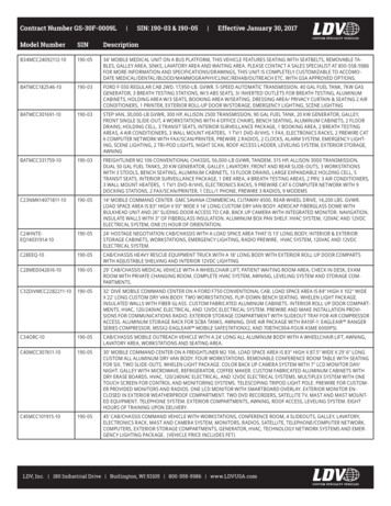
Transcription
S-190 Unit 4: TopographySummary:The ability to identifying, analyzing, and using relevant situational information about topographicfeatures can help predict wildland fire behavior is the responsibility of everyone on the fireline.Incident Position Description (IPD) Alignment:This unit aligns with the following FFT2 IPD specific n-ipd): Apply the knowledge of fuels, terrain, weather, and fire behavior to decisions and actions.Objectives:Students will be able to: Identify topographic features found in the wildland fire environment. Describe the basic characteristics of topography and how they can affect wildland fire behavior.Unit at a Glance:TopicMethodDurationUnit IntroductionPresentation5 MinutesTopographic RepresentationsPresentation5 MinutesTopographic FeaturesPresentation20 MinutesTopographic CharacteristicsPresentation15 MinutesTotal Unit Duration45 MinutesMaterials: Incident Response Pocket Guide (IRPG), PMS 461, https://www.nwcg.gov/publications/461. NWCG Glossary of Wildland Fire, PMS 205, https://www.nwcg.gov/glossary/a-z. Notebooks for participants. Ability to display images and video on large screen. White board or easel access for group breakout.NWCG S-1901 of 32
S-190 Unit 4: TopographySlide 1S-190 Unit 4: TopographyS-190 Unit 4: TopographyNWCG S-19012 of 32
Unit 4: TopographySlide 2 Review unit objectives.NWCG S-1903 of 32
Unit 4: TopographySlide 3TopographyThe arrangement of the natural and artificial physicalfeatures of an area.S-190 Unit 4: Topography3 Topographic influences on wildland fire behavior are much easier to predict than the influences offuel and weather. Topography can be broken up into two primary categories: Topographic Features: Canyons, ridges, chutes and saddles, and natural, or constructed barriers. Topographic Characteristics: Slope, aspect, and position on slope.NWCG S-1904 of 32
Unit 4: TopographySlide 4Topographic RepresentationsBasic Land Navigation, PMS 475,https://www.nwcg.gov/publications/475S-190 Unit 4: Topography4 Topography has a direct affect on wildland fire behavior. Fire personnel use various tools to assessand gather information about the topography of an area. A topographic map is an example of the most common tool that provides a picture of the terrain andconstructed features through the use of contour lines, colors, and symbols. Contour lines represent the shape and elevation of the land, such as ridges, valleys, and hills. Colors and symbols are used to represent other features on the land, such as water, vegetation, roads,boundaries, urban areas, and structures. This unit references topographic maps and some of the basic information which can be derived fromthem. However, basic land navigation and map interpretation are not an intent of this unit or course.Note to Instructor For individuals who are interested, Basic Land Navigation, PMS 475,https://www.nwcg.gov/publications/475, is a self-study introduction to land navigation. It can bedownloaded at not cost. Or hard copies can be ordered from the NWCG NFES Catalog – Part 2:Publications, PMS 449-2, https://www.nwcg.gov/publications/449-2.NWCG S-1905 of 32
Unit 4: TopographySlide 5Topographic RepresentationsS-190 Unit 4: Topography5Pre-Video Discussion Various programs and applications can provide topographic representations in 3D. The video is an example of a detailed representation of topographic features that can be generatedthrough Google Earth. Play VideoTitle Topographic RepresentationsSummary Aerial topographic representation of the location of the 1994 South Canyon Fire onStorm King Mountain, near Glenwood Springs, CO.Time (01:40)No AudioNWCG S-1906 of 32
Unit 4: TopographySlide 6Topographic FeaturesCanyonsRidgesChutes and SaddlesNatural and Constructed BarriersS-190 Unit 4: Topography6 Reference Look Up, Down and Around in the Incident Response Pocket Guide (IRPG), PMS 461,https://www.nwcg.gov/publications/461.Note to InstructorEach topographic feature, and examples of these features, will be discussed separately on slides 7-18.NWCG S-1907 of 32
Unit 4: TopographySlide 7Narrow CanyonFires starting in steep narrow canyons can easily spread tofuels on the opposite side due to radiant heating andspotting.S-190 Unit 4: Topography7 Increases in wind and strong upslope air movement can be expected at sharp bends in the canyon.NWCG S-1908 of 32
Unit 4: TopographySlide 8Box CanyonClassified as a steep-sided, dead end canyon.S-190 Unit 4: Topography8 Fires starting near the base of a box canyon can react similar to a fire in a fireplace. Air will bedrawn in from the canyon bottom creating very strong upslope drafts. The upslope draft can create rapid fire spread up the canyon, also referred to as the chimney effect.NWCG S-1909 of 32
Unit 4: TopographySlide 9Wide CanyonFire in a wide canyon can be heavily influenced by wind.Prevailing wind direction can be altered by the direction ofthe canyon.S-190 Unit 4: Topography9 Cross-canyon spotting of fires is not common, except in high winds. Drastic differences in fire behavior will occur on north or south aspects of the canyon.NWCG S-19010 of 32
Unit 4: TopographySlide 10RidgesA long narrow elevation of land; a steep slope or a similarrange of hills or mountains.S-190 Unit 4: Topography10 A ridge is a common topographic feature typically consisting of a long high area that slopes down totwo different aspects on either side. Reference the following four types of ridges in describing the predominate topographic features of anarea:1. Dominant.2. Spur.3. Flat.4. Knife.Note to InstructorEach of the four types of ridges will be discussed separately on slides 11-14.NWCG S-19011 of 32
Unit 4: TopographySlide 11Dominant RidgeForms a prominent skyline feature and may have one ormore spur ridges that connect to it.S-190 Unit 4: TopographyNWCG S-1901112 of 32
Unit 4: TopographySlide 12Spur RidgeA small ridge which extends finger-like from a main ridge.S-190 Unit 4: TopographyNWCG S-1901213 of 32
Unit 4: TopographySlide 13Flat RidgeHas terrain that slopes down gently from one or both sidesof the ridgeline.S-190 Unit 4: Topography13 Often make good places for fire containment because of easier travel along the ridge and moderatefire behavior.NWCG S-19014 of 32
Unit 4: TopographySlide 14Knife RidgeHas steep slopes that extend down both sides of theridgeline.S-190 Unit 4: TopographyNWCG S-1901415 of 32
Unit 4: TopographySlide 15Ridge Influence on Fire BehaviorRidges may offer a good place to assist in containing a fire.S-190 Unit 4: Topography15 When fires reach a ridgeline, the rate of spread often slows as it encounters an opposing upslopeairflow from the other side of the ridge. This effect can slow the fire spread and limit spotting concerns on the opposite slope. However, the effect of erratic winds caused by various winds converging at the ridgetop can changefire behavior. This is especially likely if the winds on one side of the ridge are stronger than theother.NWCG S-19016 of 32
Unit 4: TopographySlide 16Topographic Map Representation of a RidgeAt a quick glance, what information can the map provideabout this ridge?S-190 Unit 4: Topography16Question: At a quick glance, what information can the map provide about the ridge?Answer: It is a named landmark feature (Pony Ridge), so it can be used as a point of reference.Answer: It provides information on the shape and elevation of the area.Answer: Colors provide information on the predominate vegetation cover; green shadingindicates woodland.Question: How would fire personnel benefit from obtaining information on the fuel availability?Answer: Terrain indicates a baseline on the quantity of fuel available for combustion based onslope, aspect, and other terrain features.NWCG S-19017 of 32
Unit 4: TopographySlide 17SaddlesSaddleDepression or pass in a ridgeline.S-190 Unit 4: Topography17 Wind blowing through a chute or saddle can increase in speed as it passes through the constrictedarea and spreads out on the downwind side. The effect on fire behavior can lead to a change in direction and an accelerated rate of spread. This effect is similar to the chimney effect associated with box canyons.NWCG S-19018 of 32
Unit 4: TopographySlide 18ChutesChuteFairly narrow and straight depressions that lead up aridgeline.S-190 Unit 4: Topography18 Wind blowing through a chute or saddle can increase in speed as it passes through the constrictedarea and spreads out on the downwind side. The effect on fire behavior can lead to a change in direction and an accelerated rate of spread. This effect is similar to the chimney effect associated with box canyons.NWCG S-19019 of 32
Unit 4: TopographySlide 19Natural and Constructed BarriersNaturalConstructedA barrier is any obstruction to the spread of fire, typicallyan area or strip devoid of combustible fuel.S-190 Unit 4: Topography19 Barriers to fire may include both natural or constructed types. Natural barriers include:o Rivers.o Lakes.o Rocks.o Rock slides. Constructed Barriers include:o Roads.o Highways.o Reservoirs. Most barriers are effective at limiting or slowing surface fire spread. Containment lines created byfirefighters are classified a constructed barrier.NWCG S-19020 of 32
Unit 4: TopographySlide 20Topographic Map Representation of a BarrierAt a quick glance, what information can the map provideabout this barrier?S-190 Unit 4: Topography20Question: At a quick glance, what information can the map provide about the barrier?Answer: It is a named landmark feature (Salmon River), so it can be used as a point of reference.Answer: It provides information on the shape and elevation of the area.NWCG S-19021 of 32
Unit 4: TopographySlide 21Topographic CharacteristicsSlopeAspectPosition on SlopeS-190 Unit 4: Topography21 Have direct influence on fuel temperature and moisture. The characteristics presented in this unit are: Slope. Aspect. Position on slope.Note to InstructorEach characteristic and example will be discussed individually on slides 21-26.NWCG S-19022 of 32
Unit 4: TopographySlide 22SlopeThe amount or degree of incline on a hillside.S-190 Unit 4: Topography22 The slope of a hill side is what is referred to when describing how steep it is. It can affect the amount of fuel available.NWCG S-19023 of 32
Unit 4: TopographySlide 23SlopeThe ratio between the amount of vertical rise of a slope andhorizontal distance as expressed in a percent. One hundred feet ofrise to 100 feet of horizontal distance equals 100 %.S-190 Unit 4: Topography23 For example, a highway sign in a mountainous area may say 6% grade ahead. This indicates that forevery 100 feet you travel, you will gain, or lose 6 feet in elevation. A fire at the 0-5% slope range is primary influenced by wind and fuel arrangement. It typicallydevelops and spreads at a slower rate. A fire at the 30% slope range has the potential to develop and spread uphill at a faster rate.NWCG S-19024 of 32
Unit 4: TopographySlide 24Slope and Rate of SpreadSlope affects fire behaviorFaster ignition and spreadBurning chunksrolling down slopeFresh airS-190 Unit 4: Topography24Rate of Spread – The relative activity of a fire in extending its horizontal dimensions. Usually it isexpressed in chains or acres per hour for a specific period in the fire's history. The slide is a visual example of a fire developing in the 30% slope range and the slope’s effect onrate of spread. Fires move at a faster rate of spread uphill than downhill; therefore, the steeper the slope, the fasterthe rate of spread. Convective and radiant heating are key factors in this rate of spread. The fuels above the fire arebrought into closer proximity with the progressing fire, drying out, or preheating the fuels ahead ofthe approaching fire, making them more receptive to ignition, and increasing rate of spread. Another concern with steep slopes is the possibility of burning material rolling down the hill andigniting fuel below the main fire. Although fires typically burn slower down slope, a downslope wind can impact rate of spread andcreate what is referred to as a downhill run. Slope reversal can lead to dramatic changes in fire behavior. When a fire burning downslope reachesthe bottom and begins burning uphill on the opposite aspect, fire behavior is likely to increase.NWCG S-19025 of 32
Unit 4: TopographySlide 25AspectCardinal direction toward which a slope faces.NorthS-190 Unit 4: TopographySouth25 The aspect of a slope determines the amount of heating it gets from the sun. Therefore, it influencesthe fuel on that slope. Aspect is described by using the cardinal direction (north, east, south, west) the slope is facing. Discuss the drastic difference in fuel on the different aspects shown in the image.NWCG S-19026 of 32
Unit 4: TopographySlide 26Influence of AspectS-190 Unit 4: Topography26 South and southwest slopes are the most critical in terms of start and spread of wildland fires. South and southwest slopes are exposed to more sunlight and typically have:o Lighter and sparser fuels.o Higher temperatures.o Lower humidity.o Lower fuel moisture. North facing slopes have more shade which causes:o Heavier fuels.o Lower temperatures.o Higher humidity.o Higher fuel moistures.NWCG S-19027 of 32
Unit 4: TopographySlide 27Position on SlopeUpperMiddleLowerS-190 Unit 4: Topography27 Position on slope is a way to describe the relative location of something on the hillside. It is common to hear the terms lower, middle, and upper as a way to describe the location.NWCG S-19028 of 32
Unit 4: TopographySlide 28Position on SlopeS-190 Unit 4: Topography28 Position on slope corresponds with elevation in determining type, conditions, and amount of fuel. Position on slope is directly related to:o Types of fuels.o Moisture levels.o Wind exposure.o Temperature. Fuels at a lower position on slope and at a lower elevation will dry out and be receptive to ignitionand spread faster than fuels positioned higher on the slope.NWCG S-19029 of 32
Unit 4: TopographySlide 29Topographic Map Representation of SlopeAt a quick glance, what information can the map provideabout this image?S-190 Unit 4: Topography29Question: At a quick glance, what information can the map provide about this image?Answer: It provides information on the shape and elevation of the area.Question: How would fire personnel benefit from obtaining information on the fuel availability?Answer: Terrain indicates a baseline on the quantity of fuel available for combustion based onslope, aspect, and other terrain features. Advise participants that the images provide an example of how slope is represented on a topographicmap. On this map image, we can see that the highest point of elevation of this mountain is 12,000feet. The contour lines provide an indication of how steep the slopes are on the different aspects ofthis mountain. Task participants with describing how fire personnel could benefit from obtaining the elevation,slope, and aspect of a particular area before arriving on scene.NWCG S-19030 of 32
Unit 4: TopographySlide 30Knowledge CheckIdentify and list topographic features and characteristics.S-190 Unit 4: Topography30Video Exercise It is a representation of an area near Glenwood Springs, Colorado, known as Storm King Mountain.It was the location of the historic South Canyon Fire that occurred in July 1994. As students revisit the topographic representation from the beginning of this unit, task them withidentifying, and writing down as many topographic features as possible. Play VideoTitle Topographic Features and CharacteristicsSummary Aerial topographic representation of the location of the 1994 South Canyon Fire onStorm King Mountain, near Glenwood Springs, CO.Time (03:20)No AudioPost-Video Discussion Discuss the topographic features and characteristics identified, and describe how those features canaffect wildland fire behavior.NWCG S-19031 of 32
Unit 4: TopographySlide 31 Review unit objectives.NWCG S-19032 of 32
Apply the knowledge of fuels, terrain, weather, and fire behavior to decisions and actions. Objectives: Students will be able to: Identify topographic features found in the wildland fire environment. Describe the basic characteristicsof topography and how they can affect wildland fire behavior. Unit at a Glance: Topic

![Index [ astm ]](/img/5/stp37775s-index.jpg)