Transcription
Understanding ArcSDE GIS by ESRI
Copyright 1999–2004 ESRIAll rights reserved.Printed in the United States of America.The information contained in this document is the exclusive property of ESRI. This work is protected under UnitedStates copyright law and other copyright treaties and conventions. No part of this work may be reproduced or transmittedin any form or by any means, electronic or mechanical, including photocopying and recording, or by any informationstorage or retrieval system, except as expressly permitted in writing by ESRI. All requests should be sent to Attention:Contracts Manager, ESRI, 380 New York Street, Redlands, CA 92373-8100, USA.The information contained in this document is subject to change without notice.U.S. GOVERNMENT RESTRICTED/LIMITED RIGHTSAny software, documentation, and/or data delivered hereunder is subject to the terms of the License Agreement. In noevent shall the U.S. Government acquire greater than RESTRICTED/LIMITED RIGHTS. At a minimum, use, duplication,or disclosure by the U.S. Government is subject to restrictions as set forth in FAR §52.227-14 Alternates I, II, and III(JUN 1987); FAR §52.227-19 (JUN 1987) and/or FAR §12.211/12.212 (Commercial Technical Data/Computer Software);and DFARS §252.227-7015 (NOV 1995) (Technical Data) and/or DFARS §227.7202 (Computer Software), as applicable.Contractor/Manufacturer is ESRI, 380 New York Street, Redlands, CA 92373-8100, USA.ESRI, SDE, ArcView, MapObjects, the ESRI globe logo, ArcInfo, ArcSDE, ArcCatalog, ArcGIS, ArcMap, ArcIMS,ArcObjects, Avenue, ArcStorm, Spatial Database Engine, ArcEditor, ArcPlot, ArcInfo Librarian, GIS by ESRI, theArcExplorer logo, the ArcView logo, the ArcInfo logo, the ArcIMS logo, the ArcSDE CAD Client logo, the MapObjectslogo, and www.esri.com are trademarks, registered trademarks, or service marks of ESRI in the United States, theEuropean Community, or certain other jurisdictions.Other companies and products mentioned herein are trademarks or registered trademarks of their respective trademarkowners.
ContentsINTRODUCING ARCSDE . 1What is ArcSDE? . 2Why ArcSDE? . 3ArcSDE connection configuration options . 5ArcSDE for developers . 6DATA STORAGE . 7Data storage with ArcSDE . 8Organizing features . 9Types of features . 10Feature storage . 11Geometry storage options . 13Spatial indexing . 14Relational access and object relational access . 15Vector tables . 16Raster tables . 17THE ARCGIS GEODATABASE . 1 9The ArcGIS geodatabase . 20What is the geodatabase? . 21Geodatabase architecture . 22Accessing and using geodatabase application logic . 23Vector data . 24Raster data . 25Geodatabase storage in relational databases . 26Versioned geodatabases and distributed work flows . 27iii
THE ARCSDE ARCHITECTURE . 2 9What is an application server? . 30Direct connections . 32Connecting with a direct connect driver . 33Licensing and authorization . 34ARCSDE FOR COVERAGES . 3 5Introducing ArcSDE for Coverages . 36ArcSDE for Coverages . 37WHERE TO GO NEXT . 3 9Administrators . 40Developers . 41End users . 42ArcSDE resources . 43iv Understanding ArcSDE
1IntroducingIntroducingArcSDEArcSDEESRI ArcSDE is the geographic informationsystem (GIS) gateway to relational databases.It allows you to choose the relational databasemanagement system (DBMS) you want touse in your organization to fully integrate GISand DBMS.This book provides an overview ofwhat ArcSDE is and how it works.In this chapter: What is ArcSDE? Why ArcSDE? Configuration options ArcSDE for developers1
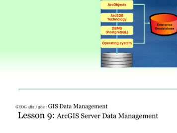
WHAT IS ARCSDE?Welcome to ArcSDE, the GIS gateway to your DBMS.ArcSDE is the software that allows you to use thefollowing ESRI products: ArcGIS suite (Desktop, Server, Engine) ArcIMS ArcSDE is a key component in a multiuser GIS because itallows you to “marry” world-class GIS technology withworld-class relational database management systemtechnology. You get to use what a GIS does best alongwith what a DBMS does best. The combination providesyou with: ArcView Support for concurrent multiuser editing with longtransactions, allowing support for many editing andcritical GIS data management work flows. ArcSDE CAD Client No limits on the size of your spatial database. MapObjects and MapObjects —Java The ability to serve many concurrent users anywhere onthe network or the Internet. ArcInfo Workstationto store, use, and manage all your GIS data (includingfeature geometry) in one of the following commercialDBMSs: IBM DB2 The ability to build custom applications from theArcSDE C and Java application programming interfaces(APIs) as well as ArcGIS, ArcObjects, and ArcIMS. A number of configuration choices. IBM Informix Microsoft SQL Server Oracle on your choice of several operating systems and scalingfrom work groups to large enterprise databases. It alsoprovides other choices for developing custom applicationsas well as how the geometry of your features is stored.All of this multi-DBMS, multiplatform/OS, multiclient,and multiple developer choice flexibility adds up to anopen, scalable solution, with more choices for users andbetter interoperability.In this book, you’ll get an overview of what ArcSDE isfor and how it relates to the ArcGIS geodatabase, as wellas a review of how ArcSDE works and where to go nextfor more in-depth information for deploying a system rcSDEArcSDEArcSDEArcSDEArcSDEDBMSDBMSDBMSArcSDE acts as the gateway between ArcGIS and your relational database. This graphic illustrates several ways to configure ArcSDE.2 Understanding ArcSDE
WHY ARCSDE?A common question to ask is: Do I need ArcSDE?Answering that requires answering another question first:Do I need a DBMS?If you are unfamiliar with DBMS technology, here is avery brief overview. Please consult with DBMS vendorsto get more information on their particular product.Chapter 2 goes into a little more detail on how data isstored in a DBMS.Why use a DBMS?As with other information resources in an organization,GIS data can benefit from DBMS use. It makes goodbusiness sense to manage your GIS resources in a relationaldatabase. Some of the reasons to use relational databasesare as valid for GIS as they are for other informationsystems: A single data store for attribute and spatial data Base relational model (so GIS is compliant with otherinformation technology [IT] system requirements)Multiuser GIS requires DBMS and comprehensive GIStools that work with the geographic data. As yourorganization evolves, your spatial databases will grow insize and number of users. Using a DBMS is a practicalmeans for sharing and protecting your data investments. Concurrency management in a multiuser environmentFor years, file-based formats have been used to manageand share information using coverages, shapefiles, grids,TINs, CAD drawings, and many raster formats. Therewere some clear advantages to doing this. First, it was easyand inexpensive. Everyone could edit and manage filebased data. No DBMS investment was necessary. Plus,DBMSs lacked the ability to manage the larger, morecomplex data types and support for operations required byGIS. In recent years, however, the use of DBMS in GIShas become more widespread. The need for managed and organized dataAs DBMS capability has evolved into more powerfultechnology that could support complex data objects, largerqueries, and stronger transactional support, the use ofDBMS for geographic data management has become muchmore practical. Most multiuser GIS systems today managetheir GIS data in a DBMS, and many smaller sites arebeginning their migration to a DBMS. Industry-standard client/server and Internetarchitectures (e.g., Web services) Standard data management practices, such as backup,recovery, and replication Performance for any number of users Scalable data volumes with no size limitations Centralized systemwide or companywide access to thedata Data maintenance over long time periods, spanningpersonnel changes and hardware and software upgrades System failure and recovery mechanismsIntroducing ArcSDE 3
The right tool for the jobResponsibility for management of geographic datasets isshared between GIS software and generic relationaldatabase management system software. Certain aspects ofgeographic dataset management, such as disk-basedstorage, definition of attribute types, associative queryprocessing, and multiuser transaction processing, aredelegated to the DBMS. Some DBMS engines have beenextended with support for spatial types, with associatedindexing and search functionality.The GIS application retains responsibility for defining thespecific DBMS schema used to represent variousgeographic datasets and for domain-specific logic, whichmaintains the integrity and utility of the underlyingrecords. In effect, the DBMS is used as an implementationmechanism for geographic datasets.ArcSDE is part of the multitier architecture (applicationand storage), where aspects related to data storage andretrieval are implemented in the storage (DBMS) tier,while high-level data integrity and information processingfunctions are retained in the application and domainsoftware (for example, ArcGIS).ArcSDE enables the same capabilities on allDBMSsAlthough all relational database vendors support SQL andprocess SQL queries in similar ways, there are significantdifferences among database vendors in the details of theirdatabase server implementation. These relate toperformance and indexing, the supported data types, theintegrity management tools, and the execution of complexqueries. These also relate to support for spatial types in theDBMS.Standard SQL does not support spatial data. The ISOSQL/MM Spatial and OGC’s simple feature SQLspecifications extend SQL by defining standard SQLlanguage for vector geometry types. DB2 and Informixsupport these standard SQL types. Oracle hasimplemented its own spatial type, while Microsoft SQLServer has no spatial type support. Spatial geometry inMicrosoft SQL Server is stored as type “image”. ArcSDEprovides the flexibility to leverage the capabilities thateach DBMS vendor offers so client applications will workthe same regardless of what spatial storage method is used.ArcSDE ensures that full spatial functionality is available4 Understanding ArcSDEregardless of the capabilities in the underlying DBMS. Forexample, if you build an ArcGIS application usingArcSDE for Oracle, that same application will work ifused with ArcSDE for IBM DB2, Informix, or MicosoftSQL Server.One of the roles of ArcSDE is to deal with the diversityand complexity in the underlying DBMS. ArcSDE is like an“adapter” for client applications to use when they want tostore and manage their spatial data in a commercial DBMS.A client application is built using the ArcSDE API, and thatclient application, with little or no modification, can workon any one of the four DBMSs or spatial storage methodssupported by the host DBMS.Fitting GIS into an IT strategyMany GIS users require that their GIS fits into a coherentinformation technology strategy for their organization.Simply put, their GIS must adhere to IT standards, the GISdata should be managed as an integral part of theorganization’s valuable data holdings, the data must besecure, and access to the data must be restricted to onlythose users that need it. These are standard advantages of aDBMS that GIS users need. Since ArcSDE provides themeans for storing and using GIS data in an DBMS withvarious GIS and non-GIS applications, ArcSDE plays animportant role in fitting GIS into an IT strategy.Data interoperability in ArcSDEData interoperability is the ability of multiple applicationsto use the same data. Sometimes that data is shared by themultiple applications, and sometimes interoperability tools(translators) are required. Many sites have multipleapplications using the same data, so interoperability is animportant issue. Other sites have multiple applications usingdifferent data types, so it’s important that applications beable to use them all.ArcSDE also plays a role in GIS data interoperability by useof spatial types in IBM DB2, IBM Informix, and Oracle.Sites can, for example, use Oracle Spatial or Locatorproducts as the spatial geometry storage method, allowingESRI’s ArcSDE client applications, as well as non-ESRIapplications, to use the same spatial data without making acopy of it as long as both applications follow the hostDBMS’s interoperability rules for application development.
ARCSDE CONNECTION CONFIGURATION OPTIONSThe ArcSDE gateway can be multitier and will run as partof a GIS client application or in a centralized server.ArcSDE can be flexibly configured to connect clientapplications directly to a DBMS (a two-tier configuration)or to run as an application server near the DBMS (a threetier configuration). There are advantages to eachconfiguration, depending on your needs.Direct connection configurationThis configuration is useful in many situations because itallows for increased scalability by offloading work fromthe server to each connected client. It also can be useful inmany failover environments because it reduces the numberof single points of failure.Application server configurationCurrently, the most common ArcSDE configurationincludes an ArcSDE Application Server. The applicationserver allows you to serve geographic data from a large,central geodatabase on UNIX, Linux , and Windows servers. The ArcSDE Application Server is typicallylocated on the same hardware platform as your DBMS,ArcIMS, or ArcGIS Server. The application serverconfiguration can offer performance advantages; duringediting, it may be faster due to the intelligent client/serverdata communications.See Chapter 4, ‘The ArcSDE architecture’, for moreinformation about two-tier and three-tier ArcSDEDBMSArcSDE has both a direct connection configuration and an application server configuration, as shown in the graphics above.Introducing ArcSDE 5
ARCSDE FOR DEVELOPERSArcSDE comes with high-level APIs for querying andworking with information in geodatabases. These include: ArcSDE Client API for C and Java developers COM API (ArcObjects) for use with the ArcGIS suiteof productsArcSDE Client APIArcSDE ships with an ArcSDE Developer Kit CD–ROM.This CD–ROM has C and Java SDK from whichapplications can be built. The ArcSDE Client APIprovides many advanced GIS functions. All ESRI clientapplications that work with the ArcSDE gateway (forexample, ArcGIS) use either the C or Java API. ArcSDEclient applications, such as ArcGIS, are large and use agreat deal of the available ArcSDE API. If you arebuilding custom applications from one of these ESRIproducts (for example, ArcGIS Engine), you won’t needto use the C or Java API. You’ll use ArcObjects (with oneof the ArcGIS Application Development Frameworks).Non-ESRI client applications can be built using a smallportion of the API to build small, focused, mission-criticalapplications—for example, in emergency response andcustomer care.These two ArcSDE APIs allow developers to buildcustom applications to work with any DBMS supportedby ArcSDE. ArcSDE has a significant third-partydeveloper community providing application solutions formany industries.ArcObjectsIf you want to build or customize an ArcGIS application,you’ll use ArcObjects. ArcObjects is the COM developer’sAPI for ArcGIS Desktop, Server, and Engine. It providesthe ability to access and work with the contents ofArcGIS geodatabases as objects with advanced GISbehavior and relationships. A Java ADF and a .NET ADFare available for use with ArcObjects. Refer to ArcGISdocumentation for more information on ArcObjectsdevelopment.6 Understanding ArcSDESQLThere are SQL APIs available for working with spatialdata. The SQL interface provided by your DBMS can beused to work with the contents of spatial databases. Sincespatial databases use standard DBMS columns, theDBMS’s SQL API is used. For a spatially enabled DBMS(for example, IBM DB2, IBM Informix, and OracleSpatial/Locator), a SQL API is available to performspatial queries directly in the database. This allows SQLquery access to feature geometry using DBMS applications.See your host DBMS documentation for spatial query SQLsyntax.
2DatastorageThis chapter is targeted for databaseadministrators and application developers andprovides an overview of the ArcSDE simplefeature model and how data is stored.In this chapter: Using a DBMS Organizing features Types of features Feature storage Geometry storage options Spatial indexing Relational access and object relationalaccess Vector and raster tables7
DATA STORAGE WITH ARCSDEThis chapter reviews the basics of the ArcSDE simplefeature model and how the data is physically stored in theDBMS. This chapter is an important building block forunderstanding the overview of the ArcGIS geodatabase inChapter 3, ‘The ArcGIS geodatabase’.requested, the appropriate values of each field are madeavailable to the application.ArcSDE extends SQL by providing tools to work withspatial data. You can also use standard SQL queries inArcSDE API to perform attribute-only queries.The first thing you should know is that data is neverstored in ArcSDE. Data is stored in tables in a DBMS.ArcSDE is the tool that allows you to use that data withGIS applications.Second, all data is stored in standard DBMS tables usingdata types available for the host database. ArcSDE usesand complements the base DBMS capability by adding aspatial component to the database. A key part of usingArcSDE is tuning the host DBMS. There can be manyperformance variables, but ArcSDE performance hingeslargely on how well the host database is tuned.object identifiergeometrygeometry-tracking fieldcoded valuedescriptive stringcontinuous numeric valuediscrete numeric valuenamesurfacewidth lanes name1014507.22asphalt85.34Old Taos Highway1023401.11concrete 45.12Calle Mejia1032321.83asphalt75.94Caitlin County Road104689.25gravel35.22Max Daniel Roadfid geom shp len typeforeign keyKey DBMS conceptsIn a relational database management system model, data isstored in tables consisting of rows and columns. The celldefined by the intersection of a row and column is called afield; the data contained in the field is a value. A rowrepresents a particular occurrence, or instance, of afeature, while the columns contain the attributes of thefeature, such as owner name for a parcel. Attributes canhave many types, such as dates, text strings, or numbers. Ageometric shape of a feature is another type of value,stored in a column that defines an abstract geometric datatype.SQL provides an interface to relational tables that allowsyou to select rows based on the values contained in thefields. A SQL statement can range from simple tocomplex, allowing you to compose virtually any type ofquery from basic column types.A query may return columns from any number of tables byjoining the tables together on key columns. A primary key(one or more columns) uniquely identifies rows in a table.The same column or columns, duplicated in another table,is called the foreign key. These keys allow tables to bejoined.The result of a query is a set of rows meeting the criteriaestablished by the SQL statement. This set is called acursor. An application can reference a number of activecursors. The application proceeds through a cursor,looking at each individual row. As each successive row is8 Understanding ArcSDEprimary keycodedescription1divided highway2arterial or collector roads3major roads4residential streets5unpaved roads
ORGANIZING FEATURESOrganizing geographic featuresArcSDE organizes features in layers or feature classes. Afeature class is a collection of one or more features of onegeometric type. A feature is a geometric representation ofa spatial object (for example, a road is represented in thedatabase as a line feature), defined as a sequence of one ormore x,y coordinates and the attributes for that geometry.Features are stored so that one row in a table equals onefeature.Logical elementsDatabase elementsObjectRowAttributeColumn, FieldClassTableUsers may logically think of a feature class as one singletable. However, ArcSDE implements a feature class asone or more tables, depending on the DBMS, the columntype used for storing the geometry, and whether or not thedata will be used in long transactions.ArcSDE doesn’t change existing DBMSs or affect currentapplications. It simply adds a spatial column to tables andprovides tools (an API) for a client application, such asArcMap, to manage and access the geometry datareferenced by that column.When you add a spatial column to a table (sometimesreferred to as a business table), you spatially enable it. TheArcSDE software manages spatially enabled tables bystoring information, such as the name of a feature class; itsowner; x,y extent; type of geometry allowed in the layer;and many other pieces of information in ArcSDEmetatables. These ArcSDE metatables are stored in thehost DBMS and are created when ArcSDE is installed.They are owned, managed, and populated exclusively byArcSDE. The schema of these tables is available in theArcSDE Developer Help (located on the ArcSDEDeveloper Kit CD–ROM). Under no circumstancesshould any ArcSDE metatable be directly modified withSQL. These tables are managed totally by ArcSDE.Data storage 9
TYPES OF FEATURESThis chapter has discussed features in a table. So whatgeometry types are supported with ArcSDE? Thefollowing graphic illustrates the feature geometries youmay store in your DBMS with ArcSDE.MultipointMultipart polylineMultipart polygonPointSingle-part polylineSingle-part polygonBasic feature storageArcSDE stores geometric shapes as x,y coordinates andtrue curves. Points are recorded as a single x,y coordinate,lines as a series of ordered x,y coordinates and curves, andareas as sets of lines composed of x,y coordinates andcurves that have the same starting and ending point.3,2 circular ,48,4from-pointchord height5,1to-point11,1ArcSDE stores a list of x,y coordinates that define the locationand shape of each geographic feature.Every geometry type in ArcSDE has a set of strictverification rules that determine whether a geometry isgeometrically correct before it is stored. Verification rules10 Understanding ArcSDEfor each shape type are described in the ArcSDEDeveloper Help (available on the ArcSDE Developer KitCD–ROM).These simple features that ArcSDE stores in a DBMS arethe building blocks on which the ArcGIS geodatabase isbuilt.
FEATURE STORAGEZ-valuesArcSDE annotationArcSDE allows you to add z-values to the x,y coordinates.Z-values can represent height or depth. Geometry may beeither two-dimensional (x,y) or three-dimensional (x,y,z).Annotation is text that labels features for cartographicdisplay. It helps identify places and features. For example,a road map can have labels that identify the names of theroads, the distances between intersections, and so on.1,02028046026040403750Z-values, such as elevations or depths, can be stored in a feature’sgeometry. In this case, points on a mountain have z-valuescontaining their elevation, in addition to their x,y position.3752375437563758Santa Anna Ave37513753375537573759MeasuresMeasures represent a distance, time, address, or some otherevent at given points along a feature. You can add measurevalues (m-values) to any geometry type. Identifying anevent by road name and distance from a known location(for example, Highway 20, kilometer 38) is a commonmethod for locating highway information, such as sign oraccident locations, exit ramps, pavement quality, andspeed zones.2868101248294Measures on a simple line shape mark traffic accidents on a highway.Measure values are independent of a geometry’scoordinate system. The x,y coordinate of a point could be(529482, 5109382) with a measure value of 248.Although many applications use measures to representincreasing linear distances along a line (see the graphicabove), measure values can arbitrarily increase, remainconstant, or decrease.Like z-values, geometry can contain a measure value(x,y,m). You could also have four-dimensional geometry byadding z- and m-values to the geometry (x,y,z,m).The street name and the addresses are attached to the street andparcel features, respectively.Annotation is a feature attribute. ArcSDE storesannotation as a feature attribute to ensure a direct linkbetween the text and the feature it labels. Annotationproperties can be stored in a single binarly large object(BLOB) column as part of the feature table, or they canbe stored in one or more related tables. See the ArcSDEDeveloper Help for more details on annotation.Annotation is usually thought of as text attached to afeature or coordinates on a map. Maps often include othertext to label nongeographic map components, such as keylegends, map titles, North arrows, and scalebars. This texthas no geographic coordinates and isn’t stored by ArcSDE.ArcSDE annotation is not the same as ArcGISgeodatabase annotation. Refer to Building a Geodatabase tocreate and maintain geodatabase annotation. ArcGISDesktop applications can view ArcSDE annotation butcannot edit it. If you need to edit your annotation withArcEditor , for example, you will need to convert yourArcSDE annotation to the ArcGIS geodatabaseannotation format.Data storage 11
CAD dataArcSDE layers can also contain CAD entities, with the aidof ArcSDE CAD Client. When a CAD entity is stored in alayer, an ArcSDE feature representing the entity is alsostored. Only ArcSDE CAD Client can work with CADentities, but other ArcSDE client applications can use thecorresponding features. Refer to ‘Using ArcSDE CADClient’ (usingcadclient.pdf in the documentation folder ofthe ArcSDE Developer Kit CD–ROM) for moreinformation.includes the coordinate system and the information neededto convert from real-world coordinates to internalArcSDE sto
Server has no spatial type support. Spatial geometry in Microsoft SQL Server is stored as type fiimagefl. ArcSDE provides the flexibility to leverage the capabilities that each DBMS vendor offers so client applications will work the same regardless of what spatial storage method is used. ArcSDE ensures that full spatial functionality is available