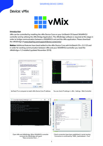
![[SURVEY PREVIEW MODE] DLIS SURVEY - Fao](/img/19/dlis-questionnaire.jpg)
Transcription
[SURVEY PREVIEW MODE] DLIS SURVEYhttp://www.surveymonkey.com/s.aspx?PREVIEW MODE .DLIS SURVEYExit this survey1. Overall, please rate your satisfaction with the FAO Desert Locust InformationService (DLIS) in providing information, early warning and forecastsNeutral - neitherVery satisfiedSatisfiedsatisfied nordissatisfiedDissatisfiedVery dissatisfiedDLIS usefulness2. Please rate your satisfaction with DLIS in the following areas:Very satisfiedSatisfiedNeutralDissatisfiedVery dissatisfiedDesert Locustsituation analysisDesert Locustsix-week forecastPresentation,format and contentof FAO DesertLocust BulletinTimeliness ofinformationprovided by DLISAccuracy ofinformationprovided by DLISUsefulness ofinformationprovided by DLISUsefulness ofcorrespondenceand feedback byemailUsefulness oftechnicalbackstopping visits(by Senior LocustForecasting Officer)Timely response byDLIS to problemsthat you face1 of 720/03/2012 09:49
[SURVEY PREVIEW MODE] DLIS SURVEYVery W MODE .SatisfiedNeutralDissatisfiedVery dissatisfiedTechnical expertiseof DLIS in solvingyour problemsProvision of usefultools by DLIS to doyour workUsefulness ofannual regionallocust informationofficer workshops3. Please rate you level of agreement with the following statements:Strongly agreeAgreeNeutral - neitheragree nordisagreeDisagreeStronglydisagreeDLIS provides auseful and reliableserviceThe informationprovided by DLIS isobjective andnon-biasedThere is sufficientstaff in DLIS toprovide a goodserviceThe staff in DLISare highlyprofessional andknow what they aredoingDLIS staff visit yourcountry enoughtimes on a regularbasis every yearYour countrybenefits from theservice of DLISDo you have any additional comments or suggestions on how DLIS can beimproved?2 of 720/03/2012 09:49
[SURVEY PREVIEW MODE] DLIS SURVEYhttp://www.surveymonkey.com/s.aspx?PREVIEW MODE .4. Please indicate the tools that you use regularly in your work and your level ofexpertise:Very goodGoodAveragePoorVery pooreLocust2eLocust2MapperNovacom GeoflexplatformRAMSESMS AccessdatabaseIRI rainfallestimatesMODIS imageryGreenness mapsPDF (PDF creatoror Adobe Acrobat)MS Office (Word,Excel, Powerpoint)Email (Yahoo,Gmail, Hotmail,Outlook)PC filemanagement5. Please rate your satisfaction with eLocust2 in the following areas:Very satisfiedSatisfiedNeutral - neithersatisfied nordissatisfiedDissatisfiedVery dissatisfiedWescor unitAntennaMagnetic vehiclemountWescor to antennacable3 of 720/03/2012 09:49
[SURVEY PREVIEW MODE] DLIS SURVEYhttp://www.surveymonkey.com/s.aspx?PREVIEW MODE .Neutral - neitherVery satisfiedSatisfiedsatisfied nordissatisfiedDissatisfiedVery dissatisfiedWescor to powercableEasy to setupeLocust2 in thefieldEasy to useeLocust2 in thefield during survey& controlEasy to enter dataAbility to enter allfield data you havecollectedEasy to send dataSends all datareliablyEasy to downloaddata to a PC fromNovacomEasy to check andcorrect data afterdownloading (usingeLocust2Mapper)Easy to export datafor RAMSES (usingeLocust2Mapper)Easy to useNovacom GeoflexplatformEasy to maintainand take care ofeLocust26. How can eLocust2 be improved?Colour screenAbility to enter more dataInclude a keyboard for typingBetter installation and updates4 of 720/03/2012 09:49
[SURVEY PREVIEW MODE] DLIS SURVEYhttp://www.surveymonkey.com/s.aspx?PREVIEW MODE .Display mapsArabic and other language versionsDo you have any additional comments or suggestions on how eLocust2 can be improved?7. Please rate your satisfaction with RAMSES in the following areas:Very satisfiedSatisfiedNeutral - neithersatisfied nordissatisfiedDissatisfiedVery dissatisfiedEasy to installEasy to useEasy to enter datamanuallyEasy to importeLocust2 dataEasy to searchdatabase anddisplay results onmapEasy to view fielddata and remotesensing imagestogetherEasy to viewrainfall and MODISimagery togetherContains all thenecessaryfunctionality thatyou needEasy to update8. How can RAMSES be improved?Better installation and updatesBetter functionality in generalBetter databaseBetter searching of data5 of 720/03/2012 09:49
[SURVEY PREVIEW MODE] DLIS SURVEYhttp://www.surveymonkey.com/s.aspx?PREVIEW MODE .Better display of dataBetter download and management of remote sensing imageryBetter display of remote sensing imageryBetter management of photosBetter map production for bulletinsBetter data summary for bulletinsDo you have any additional comments or suggestions on how RAMSES can be improved?9. Please rate your satisfaction with remote sensing products in the followingareas:Very satisfiedSatisfiedNeutral - neithersatisfied nordissatisfiedDissatisfiedVery dissatisfiedDaily IRI rainfallimages areavailable on timeDecadal IRI rainfallimages areavailable on timeMonthly IRI rainfallimages areavailable on timeIRI rainfall imagesare easy todownloadMODIS imageryare available ontimeMODIS imageryare easy todownloadGreenness mapsare available ontimeGreenness mapsare easy todownload6 of 720/03/2012 09:49
[SURVEY PREVIEW MODE] DLIS SURVEYhttp://www.surveymonkey.com/s.aspx?PREVIEW MODE .Neutral - neitherVery satisfiedSatisfiedsatisfied nordissatisfiedDissatisfiedVery dissatisfiedEasy to analyzeremote IRI rainfallimageryEasy to analyzeremote MODISimageryEasy to analyzeremote greennessmap10. How can remote sensing products be improved?Easier to download to PCEasier to display in GISEasier to analyze in GISAvailable on timeSoil moisture map (new)Dryness map (new)Do you have any additional comments or suggestions on how remote sensing imagery can beimproved?DonePowered by SurveyMonkeyCreate your own free online survey now!7 of 720/03/2012 09:49
very satisfiedverysatisfiedsatisfiedneutralDL analysisDL forecastBulletinInfo timelinessInfo accuracyInfo usefulnessDLIS feedbackDLIS visitsProblem response on timeProblem solving expertiseDLIO toolsDLIO workshopsatisfiedDLISusefulnessstrongly agreeagreeneutral02550disagreestrongly disagreeuseful & reliable serviceobjective & non-biasedDLIS staff are sufficientDLIS staff are competentDLIS visits enough timesyou benefit from DLIS0255075100 %75100 %
comments on DLIS Keep on forwarding constructive comments regarding our bulletins so that we will try toimprove it Staff in DLIS are not sufficient - need an assistant for the Senior Locust Forecasting Officer DLIS staff visit my country only one time in three years - it is not enough: should be atleast once in two years Improvement of DLIS depends mainly on the strong link that should exist with nationalPlant Protection Departments. We observe that most of the time many countries replacetheir qualified staff who are engaged in locust information services. Consequently, most ofthe new staff are new to the information system and are faced with difficulties. Therefore, Isuggest that staff of DLIS should think of organizing training to these staff to improve theirknow how and their quality of Desert Locust management. FAO to designate a permanent qualified person as a focal point in every locust affectedcountry for locust information
Are you an expert ?eLocust2eLocust2MapperGeoFlexRAMSESMS AccessIRIMODISGreennessEmailMS OfficePDFsFile mgmtvery goodgoodaveragepoorvery poordo not use0255075100 %
WescorAntennaVehicle mounteLocust2Wescor-Antenna cableWescor-Power cableeasy to setupvery satisfiedsatisfiedneutraldissatisfiedvery dissatisfiedeasy to use (survey)easy to use (control)easy to enter datacan enter all dataeasy to send datasends reliablyeasy to downloadeasy to check & correcteasy to exporteasy to use GeoFlexeasy to maintain0255075100 %improvements100 %500installkeyboardmore datamapsArabiccolour
comments on eLocust2 do not depend on vehicle battery - use rechargeable batteries (so that eLocust2could be used out of the vehicle) use less cables (antenna inside the Wescor, or use wireless) USB port instead of serial port additional GPS functionality (compass, GoTo) option to enter location names capability to send alert messages field officers should learn how to update and install eLocust2 software eLocust2 does not work in the field so must record data on Survey Form
easy to installeasy to useRAMSESeasy to enter datavery satisfiedsatisfiedneutraldissatisfiedeasy to import dataeasy to query & displayeasy to display data imageseasy to display IRI MODISfunctionally completeeasy to update0255075100 %improvements100 %500installdisplay dataRS mgmtfunctionalityquerydatabase
comments on RAMSES should work on all versions of windows, without ArcView, simple to use, and easyto reinstall include spatial, proximity and statistical analysis tools cannot view rainfall and MODIS imagery together at the same time easy to update national and sub-national (administrative region) boundaries provide a map with location names (Google Earth map) need more training
IRI daily on timeRemoteSensingIRI decadal on timeIRI monthly on timeIRI easy to downloadvery satisfiedsatisfiedneutraldissatisfiedMODIS on timeMODIS easy to downloadGreenness on timeGreenness easy to downloadeasy to analyze IRIeasy to analyze MODISeasy to analyze Greenness0255075100 %improvements100 %500soil moist maptimelinessanalysisdisplaydownloaddryness map
comments on remote sensing vegetation density should also be displayed temporal resolution image is highly recommended habitat maps that indicate preferable species for DL and crop production zones MODIS imagery and Greenness Maps to be available on time higher resolution imagery for vegetation cover (30m)
Easy to setup eLocust2 in the field Easy to use eLocust2 in the field during survey & control Easy to enter data Ability to enter all field data you have collected Easy to send data Sends all data reliably Easy to download data to a PC from Novacom Easy to check and correct data after downloading (using eLocust2Mapper) Easy to export data for .