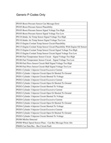
Transcription
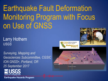
Earthquake Fault DeformationMonitoring Program with Focuson Use of GNSSLarry HothemUSGSSurveying, Mapping andGeosciences Subcommittee, CGSICION GNSS , Portland, OR25 September 2017
Overview USGS Natural Hazards Mission Shake Alert – Earthquake Early WarningSystems (EEWS)– EEWS – network based alerts– Major system components USGS Use Case for GPS/GNSS
USGS Natural Hazards Mission Every year in the US, natural hazardsthreaten lives and livelihoods and resultin billions of dollars in damage. The USGS works with many partners tomonitor, assess, and conduct targetedresearch on a wide range of naturalhazards. Major natural hazards include:– Earthquakes– Volcanoes– Landslides
ShakeAlertEarthquake Early Warning SystemNetwork Based AlertsP-wave 3.5 mi/sec (felt waves)S-wave 2.0 mi/sec (damaging waves)Alert 186,000 mi/sec
Regional Network AlertsMaximize reliability for warning timeOnsite AlertNetwork Alert
Warning TimeNetwork alerts give most users more timeOnsite vs. Network Warning TimesAssumes 4 sec processing time for network& 1 sec processing time for on-site5045Warning Time e to Earthquake Epicenter (km)Onsite SystemNetwork System160180200
Big Earthquakes are on Long FaultsM 7.8 Scenario Fault RuptureP-wave 3.5 mi/secS-wave 2.0 mi/secRupture 2.0 mi/sec
M 7.8 Scenario Fault RuptureS-P timeP-wave 3.5 mi/secS-wave 2.0 mi/secRupture 2.0 mi/sec
Long Rupture is like a chain of quakesP-wave 3.5 mi/secS-wave 2.0 mi/secRupture 2.0 mi/sec
Earthquake BeginsM7.8 SoSAFZ Scenario
Stations Sense Shaking
ShakeAlert Detects Event – Issues AlertBlind Zone(no warning)Size of “blind zone” depends on stations spacing and system speed.
Rupture Moves Up Fault
Strong Shaking Arrives – Palm Springs
Strong Shaking Arrives – San Bernardino
Strong Shaking Arrives – Orange Co.
Strong Shaking Arrives – Los Angeles
AlertShakePerformanceSpeed and AccuracyLa Habra quake:South Napa quake:M 5.1, March 28, 2014. 9:09 pm PDTM 6.0, Aug. 24th, 2014. 3:20am PDTShakeAlert Timeline09:09:42.3Origin time09:09:43.3 ( 1.0s) 1st P-wave09:09:46.3 ( 4.0s) 1st AlertShakeAlert Timeline10:20:44.4Origin time10:20:49.5 ( 5.1s) 1st Alert Upgraded stations would be faster 4 stations required for alert Size of “zone of no warning” dependson # stations required to alertSimilar performance for:M4.4 Encino Event of March 17, 2014M4.2 Westwood Event of June 2, 2014
ShakeAlert: Major System ComponentsSensorNetworksField telemetryProcessingAlert CreationAlert DeliveryUser Actions
Network TelecommunicationsDiverse Telecomm Strategy Cellular (multiple carriers)DSL, cableIP RadioDigital microwaveSatellitePublic InternetPartner systems Data telecomm from fieldsensorsStrawberry Pk.MicrowaveSensorNetworksField telemetryProcessingAlert CreationAlert DeliveryUser Actions
Alert Delivery Create and send alert and Mass notification integrationdata streams FM radio, VSAT, push, pubsub Data services (servers, cloud) New EEW products IPAWS alert authority Smartphone Apps– TV, radio, WEA, FIA, etc. Social media, etc.IPAWSSensorNetworksField telemetryProcessingAlert CreationAlert DeliveryUser Actions
Two User CategoriesPeople (the public)––––Things (automated)Social Science R&DAlert content, soundsOngoing educationMessaging, “branding”SensorNetworksField telemetryProcessingAlert Creation– Automated actions– Situational decisionmaking capabilities– User-specific applicationsAlert DeliveryUser Actions
USGS GPS/GNSS ‘use case’ (1) USGS Earthquake Program operates over 100 real-time GNSS stationsto monitor the San Andreas and other faults in Southern California. Real-time GNSS station position data at cm level accuracy are streamedinto the earthquake early warning system (EEW), Shake Alert, thatissues alert messages for public safety in case of a major earthquake. The GNSS component of the Shake Alert system augments the inertialand seismic sensors - especially important for the largest earthquakes. Real-time, uninterrupted GNSS signals are required, withoutinterference, at all times– temporary black-out of data at from stations could thwart effectiveness of the EWS– Critical impact if one or more stations are close to the epicenter of a major earthquake.– Loss of data due to RFI could increase the “blind zone” and delay delivering or degrade theaccuracy of the Shake Alert message to the public.
GPS/GNSS NetworkSouthern California
USGS GPS/GNSS ‘use case’ (2) USGS high precision application for Earthquake Early Warning(EEW) requires the broadest spectrum so as to fully utilize the GNSSsignals, including side bands, for achieving the highest stationposition accuracy possible in real-time. The 100 stations operated by USGS in real-time are only part of amuch larger collaborative inter-agency partnership. In all, over 1000 high precision GNSS stations, called the PlateBoundary Observatory (PBO), are operated by UNAVCO for theNational Science Foundation
USGS GPS/GNSS ‘use case’ (3) PBO GNSS station data are streamed in real-time and soon will beincluded into the EEW system. Added benefit is plan for inclusion of real-time GNSS data from PBOinto the NOAA tsunami alert system and USGS volcano alert system. Working with JPL/NASA, the EEW will benefit from the IGS globalarray of GNSS stations for Precise Point Positioning with AmbiguityResolution PPP(AR) processing using highly accurate GNSS orbitand clock corrections.
2004 derailmentJapanese EEW system Spent 600M on EEW after the M7.21995 Kobe earthquake killed 6,400 Public warnings since Nov. 2007sensorsStations 1000CA vs.Japan
L51176.45L21227.61152-1200 Band 1212-1243L1GPS Signals (MHz)1575.42Band 1559-159128
AcknowledgementsKen Hudnut, Ph.D.hudnut@usgs.gov(626)583-7232Geophysicist; West Coast Earthquake Early WarningSystem; Chair, GNSS Working GroupDan Determanddeterman@usgs.gov(626)583-6729Geodesist; Southern California GPS Network CoordinatorThank you
USGS GPS/GNSS 'use case' (1) USGS Earthquake Program operates over 100 real-time GNSS stations to monitor the San Andreas and other faults in Southern California. Real-time GNSS station position data at cm level accuracy are streamed into the earthquake early warning system (EEW), Shake Alert, that
