Transcription
e"7Oe (dja: # Av.eOCS StudyMMS 89-0023Historic Shipwrecks andMagnetic Anomalies ofthe Northern Gulf of MexicoReevaluation of ArchaeologicalResource Management Zone 1Volume : Executive Summary.4MISU.S. Department of the InteriorMinerals Management ServiceGulf of MexicoOCS Region
December 1989Historic Shipwrecks and Magnetic Anomaliesof the Northern Gulf of MexicoReevaluation of Archaeological Resource Management Zone 1OCS Study/MMS 89-0023, 89-0024, and 89-0025Ervan G. Garrison, Charles P. Giammona, Frank J. Kelly, Anthony R. Tripp, and Gary A. WolffTexas A&M Research FoundationCollege Station, TexasThe Minerals Management Service recently released a three-volume report entitled Historic Shipwrecks and MagneticAnomalies of the Northem Gulf of Mexico, Reevaluation of Archaeological Resource Management Zone 1. This particularreport provides a collection, evaluation, and synthesis of archaeological, environmental, and geographic data to evaluate andredefine Cultural Resource Management Zone 1 (CRMZ1) in the Gulf of Mexico. The CRMZ1 is an area considered tohave a high probability for the occurrence of historic shipwrecks. The study also worked on establishing an interpretiveframework to help identify the nature of magnetic anomalies and sidescan sonar contacts that could represent historicshipwrecks.Copies of this study can be obtained at a cost of 15.00 per set from the Minerals Management Service by referencing OCSStudy/MMS 89-0023 for Volume I: Executive Summary; 89-0024 for Volume II: Task I and Task IT, and 89-0025 for VolumeIll: Appendices. Copies of Volume I are available at no charge. Requests for copies should be made by contactingMinerals Management ServiceGulf of Mexico OCS RegionPublic Information Unit (OPS-3-4)1201 Elmwood Park BoulevardNew Orleans, Louisiana 70123-2394Telephone (504) 736-2519 or FTS 680-9519The complete report will be available in the near future from the National Technical Information Service (NTIS) at the addressbelow.U.S. Department of CommerceNational Technical Information Service5285 Port Royal RoadSpringfield, Virginia 22161NTIS Order Desk: (703) 487-4650Rush Orders: (800) 336-4700For further information, contact the Environmental Studies Section (LE-4), 1201 Elmwood Park Boulevard, New Orleans,Louisiana 70123-2394, telephone (504) 736-2897 or FTS 680-9897.
OCS StudyMMS 89-0023Historic Shipwrecks andMagnetic Anomalies ofthe Northern Gulf of MexicoReevaluation of ArchaeologicalResource Management Zone 1Volume : Executive SummaryAuthorsErvan G. GarrisonCharlies P GiammonaFrank J. KellyAnthony R. TrippGary A. WolffPrepared under MMS Contract14-12-0001-30330byThe Texas A&M Research FoundationBox 3578College Station, Texas 77843Published byU.S. Department of the interiorMinerals Management ServiceGulf of Mexico OCS Regional OfficeNew OrleansSeptember 198
DISCLAIMERThis report was prepared under contract between the Minerals Management Service (MMS) andthe Texas A&M Research Foundation.This report has been technically reviewed by the MMS andapproved for publication. Approval does not signify that contents necessarily reflect the viewsand policies of the Service, nor does mention of trade names or commercial products constituteendorsement or recommendation for use. It is, however, exempt from review and compliancewith MMS editorial standards.REPORT AVAILABILITYExtra copies of the report may be obtained from the Public Information Unit (Mail Stop OPS-34) at the following address:U.S Department of the interiorMinerals Management ServiceGulf of Mexico OCS Regional OfficeAttention: Public Information Unit (OPS-3-4)1201 Elmwood Park BoulevardNew Orleans, Louisiana70123-2394Telephone:(504)736-2519 or (FTS) 680-9519CITATIONSuggested citation:Garrison, E.G., C.P. Giammonia, F.J. Kelly, A.R. Tripp, and G.A. Wolff. Historic shipwrecks andmagnetic anomalies of the northern Gulf of mexico: reevaluation of archaeologicalresource management zone 1. Volume executive summary. OCS Study/MMS 89-0023.U.S. Dept. of the Interior, Minerals Management Service, Gulf of Mexico OCS RegionalOffice, New Orleans, La. 3 Volumes, 6 pp.
ABSTRACTAs a result of MineralsManagementService(MMS)remotesensing surveys,numerousunidentified magnetic anomalies and side-scan sonar contacts which could represent historicshipwrecks have been recorded in the Gulf of Mexico (GOM). The objectives of this study aredivided into two tasks. Task provides a collection, evaluation, and synthesis of archaeological,environmental, and geographic data to evaluate and redefine the Cultural Resource ManagementZone 1 (CRMZ1) in the Gulf. The CRMZ1 is an area considered to have a high probability for theoccurrence of historic shipwrecks.Task ! was designed to establish an interpretive frameworkthat would help identify thenature of magnetic anomalies and side-scan sonar contacts within the CRMZ1. Field studieswere conducted to determine the relationship between linespacing of magnetometer and sidescan surveys and the percentage of objects detected on the seafloor. These data were thenanalyzed to investigate whether remote sensing data gathered during a cultural resource surveycould discriminate between a cultural resource and recent debris.The results from Task indicate: (1) an increased distribution of shipwrecks in the easternGulf beyond the present CRMZ1 boundary but a low preservation potential at these wreck sites,and (2) a higher potential of finding shipwrecks around historic port areas in the central andwestern Gulf because of higher preservation potential.Recommendations to relocate the CRMZ1 based upon both the distribution of reportedshipwreck locations and their preservation potential are made. It is proposed that the CRMZ1be moved to within 10 km of the Gulf coast and that specific higher probability zones bedelineated outside the CRMZ1 that reflect the increased frequency of wrecks in the vicinity ofports and certain hazards.The results of Task Il indicate:(1) magnetic anomalies increase in direct proportion to areasurveyed, i.e. the 150 m line interval detects one-third of the anomalies compared to a 50 mline interval survey, (2) survey areas with oil and gas structures have higher numbers ofmagnetic anomalies than undeveloped survey areas, and (3) the present survey methods usedfor cultural resource surveys are not sensitive enough to differentiate between modern debrisand a potential cultural resource.Other methods can more confidently differentiate between modern debris and shipwrecks.One method forms the basis of our recommendations on Task II which suggest using 50 m lanespacing for survey areas having a high potential for shipwrecks. The recommendations in bothTask and i combine to reduce the general survey area on the Outer Continental Shelf (OCS) butincrease the effectiveness of the surveys in areas that have a high probability of both shipwreckdensity and preservation potential.
TABLE OF CONTENTSPAGEEESIERERSREELEESesRane GeMCRR hae RESereeeee!aeeegrea Ae ee Oe ee a arLIST OF FIGURESFigure -1faanaeea aaiiioe ivaeaeV -1
ACKNOWLEDGEMENTSThe programmanagerand ail of the principal investigators wouldlike to acknowledgetheassistance of the research assistants, secretaries, clerks, student technicians, student workers,laboratory technicians, draftpersons, and others who have been so instrumental in assemblingthis report for the Minerals Management Service.The management staff on this project are involved in purchasing, report writing, andclerical duties which make it possible for the researchers to implement the procedures whichare described in this report and their fine work is appreciated.The assistance of Mr. MikeHuddlesonin coordinating project business with the Texas A&MResearchFoundation, theMinerals Management Service, and outside vendors is most appreciated.Mr. William Crowcoordinated many project logistics. The contribution of Ms. Susan Hulse in organizing, typing,and editing this report is most appreciated. The special help and extended efforts of SherryGarvey, Andrea Hapeman, and Joanna Fritz are examples of how projects cannot be successfulwithout the teamwork of wonderful staff. The work of the project field staff and the crew of theUniversity research vessel, the R/V EXCELLENCE Il, is acknowledged.Their assistance in theimplementation of field sampling procedures has been very valuable and is greatly appreciated.Acknowledgement is given to student assistance Karen Trossel, Nancy Hitchcock, SusieRiley, Robert Lightfoot, Sherry Garvey, Kyle Baden, Karen Martin, and Diane Midge for theirinvaluableassistancein dataanalysis,compilation,andtransmission.Eri Weinsteinparticipated in the 1988 field surveys of lease blocks 313 and 332 as partial fulfillment ofcourse requirements in his graduate studies. Mr. Ron Pierce gave his usual fine effort inlocating materials and equipment necessary for the successful field studies. Mr. Ben Thigpenprovided expert council on survey problems, drawing on exhaustive experience in thegeophysical industry.Several vendors and their representatives provided timely service and assistance.Theseinclude Mr. Terry S. Snyder (EG&G), Mr. John Fett (John D. Fett Instruments), Mr. AlistairHelme (Harvey-Lynch, Inc.), Mr. Larry Stephenson (Harry-Lynch, Inc.), Mr. Chuck Edgington(Del Norte Technology, Inc.), Mr. Andy Bogle (STARFIX), Mr. Jack Rhodes (STARFIX), Mr. DickSmith (STARFIX), Mr. Jeff Raspberry (STARFIX), and particularly Mr. Max Huff (STARFIX).The tow-depth sensor used during the field studies was graciously provided by TeledyneExploration, Inc. through the offices of Mr. Carl Bergland. EG&G Geometrics gave its usual fineproduct support and is thanked for updating our G-866 magnetometer.Our thanks go to Mr. James Baker and Mr. James Orr for preparing the excellent DISSPLAgraphics included in this report. The staff of the Engineering Computer Services (ECS) of theEngineering Program, Texas A&M University, provided technical and advisory assistance overthe course of the study. In particular, Mr. J. Robert Shaeffer (now with Boeing ComputingServices), Mr. Jeff Cox (ECS) and the director of ECS, Dr. Donald Maxwell, are thanked. Dr.Maxwell authorized the acquisition of the NUMONICS digitizer and DEC 220/240 terminals soimportant to the manipulation and presentation of the large digital databases used in this study.The study benefited from his complete support as interim Department Head, Civil EngineeringDepartment, Texas A&M University.Dr. Robert Bruner of the Geotechnical Area, Civil Engineering Department, erected thegeodetic controls used in the resurvey of lease blocks GA 313 and GA 332. Dr. Bruner and hisson, Bill, cheerfully rode boats and helicopters to erect the offshore positions to the highestdegree of accuracy. The control points were erected on properties of Santa Fe Minerals and
ViExploration Co., Lorac, a division of John E. Chance Associates, and the United States Coast Guard(Surfside, Texas). Each of these organizations is thanked for this courtesy.We gratefully recognize ARMS,Inc. whose personnel,Mr. NathanGautheir (President),Mr. Randy Ducote, and Mr. Robert Simon were always able to accommodate our requests.During the summerfield studies several divers volunteered their assistance.Most werestudents of Texas A&M University and include: Mike Halpin, Marianne Franklin, Kenan Heideke,Alan Haubaker, Jim Hobling and Kathleen McLaughlin-Neyland.Excellent examples of graphic displays of magnetic anomalies were provided by Mr. RobertGearhart and Mr. Clell Bond of Espey-Huston and Associates, Inc., and by Mr. Rick Anuskiewicz.A photo of the machinery of the WILL O'THE WISP was generously loaned by Mr. Larry R.Martin.Finally, we wish to thank those members of the Minerals Management Service we workedwith most closely over the cours: of the study. They are: Dr. Norman Froomer, Ms. MelanieStright, Dr. Richard Defenbaugh and Dr. Rick Anuskiewicz. Their counsel and assistarce greatlyenhanced the conduct and relults of this study.
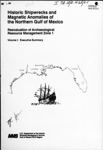
EXECUTIVEAs a rosult of Minerals ManagementSUMMARYService (MMS)required lease block remote sensingsurveys, numerous unidentified magnetic anomalies and side-scan sonar contacts which couldrepresent historic shipwrecks have been recorded in the Gulf of Mexico (GOM). These surveysalso recorded numerous examples of relict landforms (fluvial channels, terraces, point bars,bays, lagoons, barrier islands, natural levee ridges, salt diapirs, and sinkholes) where there isa high probability for associated prehistoric sites.Avoidance of further investigation of archaeologically sensitive areas is usually requiredprior to approval of lease permits; however, because industry has generally chosen avoidancerather than further investigation of these areas, little data have been collected which would helpin building an interpretive framework for the evaluation of unidentified magnetic anomalies andside-scan sonar contacts, or in evaluating the predictive model for prehistoric site occurrence.The objectives of this study are:a.To reevaluate and make recommendations to change, if necessary, the location of CulturalResource Management Zone 1 (CRMZ1) in the GOM (Figure 1).b.To determine the relationship between linespacing of magnetometer readings and sidescan sonar and the detection of objects at or below the seafloor.c.To investigate whether remote sensing data gathered during a cultural resource surveyin the GOM can be analyzed to discriminate between a cultural resource and recentdebris.This study was divided into two major tasks: Task , Evaluation of Cultural ResourceManagement Zone 1; and Task II, Establishing an interpretive framework to characterizeunidentified magnetic anomalies and side-scan sonar coniacts.The data from primary and secondary materials collected at the various archives weremerged and a master file of historic shipwrecks of the northerr Gulf of Mexico was created.This file, with over 4,000 entries, represents the largest such data base for the Gulf.Determining spatial patterns of shipwrecks in the Gulf of Mexico does not explain the causesfor these patterns. These factors are not always independent. For example, increased frequencyof shipwrecks along trade routes does not explain why the vessels were lost, only why they werethere in the first place.Factors such as poor seamanship, poor navigation, scuttling,explosions, and fire cause shipwrecks.An interesting aspect of the analyses conducted on the data in this study shows an increase inthe number of losses over time.This contradicts conclusions in previous studies where the peakfor shipwreck losses was expected to lie between 1880 and 1910. New data suggests thatshipwreck loss continues to increase through the 20th century.This fact is somewhatsurprising if one assumes that improvements in the technology of ship design, the use of diese!engines, and better navigational tools would reduce the number of ships lost over time.However, the rate of shipwrecks actually increases because of improved technology.improvedtechnology may allow more vessels to be exposed to risks that early mariners would avoidbecause of recognized shortcomings in their ships or navigational aids.
:96 TT.0 ARKANSAS oo ee.ee\SOUT CAROLINAAllanta/;.2“oa@ ALABAMAPsGEORGIA\27 Peeei » REG ade ; (ésLakeL *Tallahassee0Apalachicola R:*\ Tempe.iFIGURE4. I-1. StudyAarea,iCE!1977.i\co4
The number of ships lost in the open sea versus those lost nearshore were discussed byMuckelroy!, Bascom2, CEI3, and Marx4. Marx estimated that approximately 98 percent of allshipping losses in the western hemisphere prior to 1825 occurred in less than 10 m of waterand within 1.5 km of the coast. CEl's authors followed this proposition when developing theCRMZ1. Muckelroy suggested that the 10 m boundary probably underestimated the potential fordeep-water archaeology. Bascom concluded from a study of 19th century losses at Lioyds ofLondon that about 20 percent of all sinkings occur away from the coast.This figure probablybetter approximates the correct order of magnitude for all sinkings in the open sea at anyperiod. The data in this study support Bascom. An inspection of our shipwreck aistributionplots shows that 75 percent of shipwrecks occur in nearshore waters and the remainder in theopen sea.They conclude that wrecks are associated with the approaches to seaports, straits,shoals, reefs, and along the maritime routes.As we have seen in this study, the foregoingassumptions are largely supported by the data, bul the authors deviate from their assumptionsin the actual drawing of CRMZ1.The potential for shipwreckoverall analysis of the CRMZ1.site preservation is another important consideration in theif an area with a high potential fer historic shipwrecks lacksthe potential for preservation, that area may not need to be included within the boundary of theCRMZ1. An example of an area with negative environmental factors for site preservation is theregion at the mouth of the Mississippi River.concentration.By historic accounts, it was an area of high shipThe tremendous sediment deposits off the Mississippi Delta militate againstfinding a shipwreckin that area dueto sedimentsof a depth that would insulateit fromdiscovery.Ships falling on areas of moderate to high sediment depths, hypoxic burial conditions, andlow current regimes have good preservation potential.These conditions characterize much ofthe western and the west-central areas of the northern Gulf. It cannot be stated unequivocallythat vessels sinking in sediment starved areas of the shelf, such as that of the eastern Gulf area,cannot be preserved, but based on results of this inquiry that probability seems low. in an areawhere burial or protection by fouling organisms exist, biofouling must be rapid in order topreserve vessel fabric or cargo.Until better data is available for the eastern Gulf, ourexpectation is that much of that area will be characterized by poor preservation of historicshipwrecks.Records for shipwreck locations were merged with our assumptions concerning shipwreckpreservation to derive a model for the potential of finding shipwrecks in the GOM.1K. Muckelroy.2W. Bascom.1977.1971.Maritime Archaeology. Cambridge University Press.“Deep Water Archaeology.”Science.Cambridge.174(4006): p. 261-269.3 Coastal Environments, inc. 1977. “Cultural Resources Evaluation of the Northern Gulf ofMexico Continental Shelf." 3 Volumes. Baton Rouge, Louisiana. National Technical informationServices (NTIS) as: Vol. , Prehistoric Cultural Resource Potential, PB276773/AS; Vol. ,Historic Cultural Resources, PB-276774/AS; and Vol. Ili, Maps, PB-286-874/AS.4 Marx, R.F. 1971. Shipwrecks of the Western Hemisphere, 1492-1825. David McKayCompany, inc.,New York, NY.VLA
-4The conclusions are derived from our present understandingnorthern Gulf of Mexico. Our study results indicate:Pof the shipwrecks in theIncreased distribution of shipwrecks in the eastern Gulf area beyond the present CRMZ1boundary but a lower preservation potential relative to the central and western Gulf:Previous underestimations of early shipwrecks in the central and eastern Gulf areas:Increased potential of unreported shipwrecks in high density areas, e.g. a higherpotential of finding wrecks in these zones because of higher preservation potential.Recommendations for revisions of the CRMZ11.include:Move the current CRMZ1 to within 10 km of the Gulf coast based upon the distribution ofreported shipwreck locations and their probability of preservation.Delineation of specific higher probability zones to reflect the increased frequency ofshipwrecks in the vicinity of ports and certain ‘azards. They should nave guidelines a’least equal to those for the CRMZ1 and include:a Brazos Santiago-South Padre isiand (TEXAS);Corpus Christi-Mustang Island (TEXAS);Freeport-Matagorda island (TEXAS);Galveston-High Island (TEXAS);Sabine River (TEXAS);Caicasieu (LOUISIANA);Barataria Bay/Grande Isle (LOUISIANA);West Bay-Mississippi Delta (LOUISIANA);East Bay-Chandeleur Isiands (LOUISIANA);Mississippi-AlabamaBarrier Complex (Cat, cola-Santa Rosa Island (FLORIDA);Appalachicola-Cape San Blas (FLORIDA);. Cedar Key (FLORIDA);Horn,PetitBois,DauphinTampa-St. Petersburg (FLORIDA);Cape Sable (FLORIDA); andDry Tortugas-Marqueses (FLORIDA).FPera"Recognize individual blocks outside high probability zones and CRMZ1to the occurrence of specific historic shipwrecks.These biocksadjacent blocks should be considered as localized high probabilitysurveys should consider the specific block and the eight contiguousconducted within these newly defined zones should utilize therecommended based on the results of the second part of this study.proper accordingand immediatelyareas such thatblocks. Surveyssurvey methodsBased on Task , we have indicated areas on the GOM OCS that have high, moderate, and lowprobabilities for the occurrence of historic shipwrecks. Task I! of this study was designedtoestablish an interpretive framework to characterize unidentified magnetic anomalies and side-
scan sonar contacts within the CRMZ1.It has the following two efforts:(1) Informationcollection; and (2) information analysis and synthesis. Two previously surveyed lease blocks(one that was not subsequently developed, and one that has been developed) were resurveyed formagnetometer and side-scan sonar data with survey linespacing at 50 m and navigation systemaccuracy at 5 m. These data and the data from the original lease block survey were analyzed todetermine the following:viThe percentage of anomalies recorded during the survey at 50 and 100 m linespacingsthat was recorded during the original lease block survey at 150 m linespacing;The correlationin anomaly locations, amplitude,duration,(dipolar/monopoiar) between the original and new surveys; andandsignatureThe number of new magnetic anomalies and/or side-scan contacts that were recordedwithin the developed lease block, and the location of these anomalies relative to oil andgas structures.Sites within lease blocks were selected for groundtruthing and signature characterization ofunidentified magnetic anomalies and side-scan sonar contacts. Anomalies were chosen from theresurvey sites as discussed above. Groundtruthing and signature characterization included thefollowing:1.2.Relocating the anomaly or contact and collecting magnetometer and/or side-scan sonardata at a linespacing of 50 m or less;Constructing a three-dimensional magnetic contour map of the unidentified magneticanomalies, and magnetic anomalies with associated side-scan sonar contacts;Identifying the source of the anomalous contact through diver inspection, using a handheld metal detector; andPhotographing any marine debris and historic shipwrecks where observable at theseafloor.The results of the resurvey and groundtruth efforts include:1.2.Post-plot maps that show the track of the survey vessel and navigatiorial fix points at a1:1200 scale and compare the findings of the original lease block survey with theresurvey data; andContour maps with a two gamma contour spacing of each magnetic anomaly that wasinvestigated, and a catalogue of magnetic signatures for each object.(a)The survey and groundtruthing methods, and the instrumentation used isdescribed and survey findings are discussed.(b)All the data collected during the field surveys were analyzed to determine therelationship between survey linespacing and anomaly detection, the influence ofoil and gas structures on magnetic anomaly distribution and to characterize thechanges at different distances and orientations to the magnetic sensors. The goalof the pattern recognition analysis of magnetic and side-scan sonar signatures isto develop a method that differentiates resources, and that can be used by MMScultural resource analysts in the cultural resource survey review process.
The following is a summary of the results:1.The detection of magnetic anomalies increases in direct proportion to the lanespacingused, e.g. the 150 m line interval detects one-third of the anomalies found using a 50 mline interval. This result may be specific to this particular study and the linear trendmay differ with other data.2.The survey of the developed lease block with oil and gas structures had the highestnumber of magnetic anomalies relative to the two undeveloped blocks surveyed. Weconclude that development increases the number of anomalies of modern origin.3.The present survey methodology is not developed enough to differentiate, at a highconfidence level, between modern ferromagnetic debris and potentia! cultural resources.It represents a compromise between scientific and economic goals.The present study demonstrates methods by which one can more confidently characterizemodern ferromagnetic debris and potential cultural resources. Pattern recognition has beendemonstrated by using 50 m or less lanespacing by other state and federal agencies such as theTexas Antiquities Committee, the National Park Service, and the U.S. Army Corps of Engineersor by use of groundtruthing.Recommendations to alter the present methodology have been made in the past MMS sponsoredstudies rotably CE! and SAIS5 that still have merit. These include: conducting side-scan,magnetometer, and sub-bottom profiling surveys using 50 m linespacing in high shipwreckpotential areas and limiting vessel speed to 2-3 m/s (4-6 knots).The recommendationsinboth Tasks and Il combine to reduce the general survey area on the OCS but increase theeffectiveness of the surveys in lease block areas of reported shipwrecks with a high potentialfor their preservation.5 Science Applications, inc. 1981. “A Cultural Resource Survey of the Continental Shelf fromCape Hatteras to Key West.” 4 Volumes. McLean, VA.
The complete report will be available in the near future from the National Technical Information Service (NTIS) at the address below. U.S. Department of Commerce National Technical Information Service 5285 Port Royal Road Springfield, Virginia 22161 NTIS Order Desk: (703) 487-4650 Rush Orders: (800) 336-4700