Transcription
Precinct 20Canning River – Tonkin Highway to Turner/Brookside Footbridge1
SummaryCanning River – Tonkin Highway to Turner/Brookside FootbridgeThe Canning River meanders irregularly downstream towards TonkinHighway in the form of a narrow and shallow channel. The river is quiteuniform in width for most of this precinct and has an almost verticalembankment of clayey red alluvium above the river Channel. The fringingvegetation is a flooded gum - paperbark complex which due to clearing hasbeen reduced to a narrow belt along the river channel.There is an abundance of weeds which form a denseunderstorey in the disturbed riparian vegetation community. Theprecinct is part of the palaeo alluvial fans in front of the DarlingRange and the landform is gently undulating, flat topography onthe western river bank. The eastern bank becomes quite hillywith several steep gravelly slopes.There are two pedestrian crossings within the precinct both rastructure, such as pipelines and powerlines. The adjacentvegetation is also infested with weeds giving the area lowaesthetics.There are several small residential blocks in the area, howevermost properties are long narrow horticultural blocks which stretchfrom the road to the river. There is also a large proportion of landowned by the Salvation Army who provides residential supportfor senior citizens and a rehabilitation centre adjacent to the river.2
Resource InformationBiophysical ProcessesErosion and accretionGeological ProcessesThere is severe erosion of the valley embankment where themain river channel has collided with the edge of the river valley atThe precinct is included in the Guildford Geological FormationPries Park. Tree roots are exposed just upstream of Manningwhich consists of sandy clays and clayey sands, and alsoAvenue Footbridge. There are several points of erosion andincludes other alluvium and colluvium. The formation consists ofsiltation along the stream between McKenzie Grove and Priesmixtures of sand, clay and conglomerate. The unit is of fluvialPark Road. There is some erosion due to the effects of grazingorigin but includes estuarine and marine intercalations near itslivestock on the western bank upstream of Centre Road (Daybase. East of the river there are pockets of the Yoganupand Pen, 1991).Formation which is leached or ferruginised beach sand andVegetation Communitiesconglomerated dunes. This is believed to have been deposited inthe Quaternary period as a fore or beach dune under active surfconditions.NativeThe river channel and flood plains are part of the SwanSwan ComplexAssociation red podsolic and undifferentiated alluvial earths andThe indigenous flora of this precinct is classified as being as partduplex soils. On either side of the riparian soil association, is theof the Swan Complex (DCE, 1980).Forrestdale Soil Association. This is composed of the gravellyand sandy soils of the laterised foothills of the Ridge Hill Shelf.The vegetation ranges from fringing woodland of flooded laleucarhaphiophylla) with localised occurrence of low open forest ofsheoak (Casuarina obesa) and saltwater paperbark (MelaleucaThe river is part of the Pinjarra Plain which consists ofcuticularis). The various communities which make up thisunconsolidated fluvial originated sediments. The Ridge Hill Shelfcomplex are described below.is located in front of the Darling Scarp. The shelf formationconsists of palaeo alluvial fans which have formed in front of theEucalyptus-Melaleuca communitiesDarling Scarp by fluviatile processes.The Eucalyptus rudis-Melaleuca rhaphiophylla low open-closedforest is found fringing the Canning River in this precinct. FewHydrological Processesindigenous understorey species remain, and the dominantWater featuresfasicularis and variable leafed grevillea (Grevillea diversifolia)understorey species include the large exotic shrub Astarteawhich occur particularly towards Brookside Avenue. In manyThe river takes the form of irregular meanders within thisareas the riverbanks have been cleared of riparian vegetationprecinct. The channel is reasonably uniform in width with only aand replaced with pasture or else the understorey has beenslight broadening at the meander bends. The river cuts throughremoved and the land converted to pastured woodland.the red alluvium forming steep embankments of approximatelytwo metres in depth. Adjacent to the channel is a narrow floodEucalyptus communitiesplain area which quickly rises to meet the undulating sandy plain.The vegetation on the hills behind the river communities isremnant marri (Eucalyptus calophylla) and jarrah (EucalyptusBathometrymarginata) tall open forest formation which provides anattractive background to the river environment. The understoreyThe channel is quite shallow with a depth of less than one metre.is less disturbed compared with the river complex and there isThe river is entirely fluvial and there are several shallow narrowan abundance of blackboy (Xanthorrhoea preissii) and hibbertiatributaries which drain the surrounding land.(Hibbertia sp).FloodingThere is a narrow flood plain although most of the area is notsubject to seasonal inundation or the formation of damplands.3
Precinct 20 – Canning River – Tonkin Highway to Turner/Brookside FootbridgeSites of Nyungar & Wider AustralianCommunity SignificanceExoticThere are several prominent weeds along the river bankNyungar significanceincluding the castor oil bush (*Rininus communis), bulrush(*Typha orientalis), giant bamboo (*Bambusa sp), willow treeterebinthifolius),The Beeliar and Beeloo or river people are believed to haveblackberry (*Rubus sp) and edible fig (*Ficus carica). There areconsidered this section of the Canning River as part of their runseveral citrus orchards within the area.(O'Connor et al, 1989). The Beeloo considered north of the(*Salixsp),Japanesepepper(*ShinusCanning River (Dyarlgarro) to the hills as part of their groundHistorical Land Use and ResultingEnvironmental Changeswhile the Beeliar mainly traversed the southern section of theThe area has been historically used as pastoral land and this hasOther significanceriver to the sea.resulted in the Clearing of the native vegetation (McDonald andCooper, 1988). Many orchards were established on the relativelyThere was a traffic bridge at Turner Road until 1981 when it wasrich soils and some of these remain today.demolished and replaced with a new pedestrian walkway(McDonald and Cooper, 1988).Present Land Use and Social PatternsConservation AreasThe Harry Hunter Rehabilitation Centre is located on thenorthern side of the Canning River and is secluded by bushland.WetlandsOn the opposite bank the Seaforth Senior Citizens Centre run bythe Salvation Army is a series of single storey units. Adjacent toThe section of Canning River in this precinct has been identifiedthe rehabilitation centre is a block of bushland being the site of aas a multiple use management category by WAWA (1993).proposed crematorium.These wetlands are perceived as having a significant number here are several large rural blocks which stretch to the riverrecommended to be considered in the context of 'sustainable'foreshore. These are used as rural residential lots, horsecatchment management. It is recognised that these clearedpaddocks and small orchards. There are several citrus orchardswoodlands and grasslands provide valuable pasture for grazingwithin the area, the larger of which are just south of Tonkinand also support bird feeding and breeding grounds.Highway and in line with Lake Road on the western side of theSystem 6river. Behind Cunnell Avenue are small residential blocks whichhave been formed as the result of subdividing the larger originalblocks.M75 Upper Canning and Southern RiversThe recommended area comprises the Canning River and itsfringes from Nicholson Road to the boundary of the State Forest,Recreation nodestogether with those parts of the Southern and Wungong RiversThere are several recreation nodes within the area. Pries Park iswithin the City of Gosnells. Much of the area is reserved for parksthe largest area and has facilities for a soccer club, pony club andand recreation under the Metropolitan Region Scheme. The riverother organised sports. Quarry Park is on the corner of Cockramis well fringed with flooded gums and paperbark although theand Mills Roads and has a shallow creek and barbecues inground flora has been almost eliminated by grazing and clearing.shaded grass areas. Wright Brook Regional Park is adjacent toThe area is significant for its open space of regional significancethe study area and has significant conservation and wthandregeneration of flora and fauna and preventing vehicular accesswhile allowing low impact access to the river.Public accessPublic access to the river is limited to the Manning Road andTurner Avenue pedestrian bridges. The majority of the landadjacent to the river is private and fenced right down to thefringing vegetation line which makes it difficult to access.4
5
6
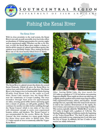
Landscape DescriptionPrecinct DescriptionOn the eastern bank is the very tall metal main distributary powerline which dominates the skyline. The pedestrian bridge areaWaterform and natural riparian zonebecomes a node of service infrastructure and due to theabundance of weeds within the fringing vegetation is anThe river takes the form of a narrow and shallow channel whichunattractive viewscape.in parts has almost vertical embankments through the redalluvium. The steep embankments and restricted flood plain areThe Turner Place pedestrian bridge is a simple narrow concretegenerally vegetated with weeds. There are several tributarysuperstructure with of steel wire with metal hand rails. Thestreams entering the river. The larger tributaries are the Quarryabutment is made up of local red rocks and there are small stepsPark Stream and Wright Brook which run through the Harrycut into the rock allowing access to the river channel. There areHunter Rehabilitation Centre. These streams are narrow shallowtwo service pipes which cross the river adjacent to the bridge.channels which are fringed by vegetation until the edge of thechannel embankments. The stream embankments are generallyLand usevoid of vegetation and the red colour of the alluvium is exposedon their steep sides. The streams form pool and riffles where theThe houses south of Tonkin Highway are on large blocks andlaterised bedrock is exposed.they all have a semi rural feel created by informal gardens,vegetable patches and rural-styled wooden and wire fences.LandformSouth of Manning Road the blocks become long narrow pieces ofland which front onto the river. These are mainly used asThe precinct is part of the alluvial fans in front of the Darlingpaddocks and orchards. Many of the properties have smallRange and as a consequence the landform takes a gentlyinformal shops or sheds adjacent to Albany Highway from whichundulating flat topography on the western river bank, while on thefruit, vegetables and flowers are sold and these provide a ruraleastern bank the land becomes quite hilly. The eastern bankcharacter to the area. Several plant nurseries are located alongaround Wright Brook Regional Park has several steep gravellythe highway.hills which give way to a flat sandy bank before the river. TheDarling Range acts as a dramatic backdrop to the relatively flatThe Salvation Army owns land on the western and eastern bankslandscape.of the Canning River. They have the Seaforth Senior CitizensCentre and the Harry Hunter Rehabilitation Centre. Both of theseVegetationhave neat modern housing units which are built away from theroad and close to the river. The Senior Citizens Centre is mainlyThe vegetation along the river channel continues to be thedevoid of trees, however there are some gardens around theflooded gum and paperbark complex. Most of this has beencomplex which are well maintained and have a colourful displaycleared except for a line of vegetation along the river and theof flowers.understorey consists of a dense mat of weeds. There are fewareas of uncleared land, however near Cockram Road andSouth of the Seaforth Centre is a caravan village which hasWright Brook there is an area of remnant marri and jarrah tallmature local and non indigenous gum trees planted for shade.open forest community which provides an attractive backgroundThe caravans are mainly occupied by permanent residents andto the river environment. The understorey is less disturbedtherefore many have small gardens around their lots. Thecompared with the river complex and there is an abundance ofcaravan park has lawn up to the thin line of natural riparianblackboys and hibbertia. Unfortunately, part of the Cockramvegetation.Road bushland has been recently burnt which has temporallyreduced the scenic quality of the vegetation.There is a small housing development around Ciro Road whichwas established in the 1980s. The houses are on small blocksRiparian land useand are generally neatly maintained. The end properties faceonto Wright Brook.Manning Road pedestrian bridge is an unattractive feature as it isgraffitied and has wide exposed concrete abutments. Adjacent tothe pathway is a concrete half drain which guides stormwater intothe river. A large silver water pipeline runs parallel to the bridgeand has a wire fan shaped barrier to prevent people climbing onthe pipe. There is a light pole and pine bollards which also add tothe clutter of amenities.7
Precinct 20 – Canning River – Tonkin Highway to Turner/Brookside FootbridgePries Park has facilities for several sporting groups. KelmscottPony Club at the end of Cockram Road is 'Strictly Members Only'and has several paddocks with equestrian equipment in thefields. Much of the vegetation has been cleared and the mainfield is very sandy. On the rise of the hill are two ovals andclubhouse. The clubhouse has several sponsors’ signs on thewalls. The area is well fenced and it is difficult to access the river.Quarry Park is a small recreational park created by a local quarrycompany. It is open to the public during the daytime, however isclosed during the evening. The park has a small creek and theland that was once cleared has had several trees replanted tocreate a parkland effect. The park has barbecue and playequipment facilities.8
Landscape InterpretationDominant Landscape CharacterMuch of the riparian vegetation along this section of the CanningRiver is in poor condition. There is the opportunity to improve theThis precinct is dominated by a rural landscape character. Thereenvironmental condition and the aesthetics of the landscape byare many relatively large blocks which are being used forremoving the abundant leafy weeds and grasses andorchards, horse agistments and small market gardens. Theseencouraging the regrowth of the attractive flooded gum andproperties have been cleared of the indigenous vegetation,paperbark community.except in some cases where a very narrow ribbon of riparianvegetation remains. There are several large blocks which areAt present, Pries Park is a detracting element in the landscape.only being used for residential purposes; however these have theThe park could be enhanced by planting indigenous speciesappearance of a rural land use, due the low building density.around the edge of the park and improved maintenance of thegrounds. At present, there are large advertising signs andIncreasingly, the large blocks have been subdivided for relativelyrubbish tends to collect along the fence line of the property.high density residential developments. These pockets ofRecommendations for Maintenance andEnhancement of the Present LandscapeCharactersuburban landscape are characterised by modest style housesand eclectic gardens. There are several retirement complexes inthe area, the largest being the Seaforth Senior Citizens Centreon Albany Highway. Rehabilitation of the riparian vegetation and erosion pointsThere are two recreational landscapes. Quarry Park is generallyalong this reach of the Canning River. The area is particularlya passive recreational landscape with facilities for picnics andweedy and the riparian natural landscape needs to bewalks. Pries Park is used for several organised sporting activitieswidened to improve the aesthetics of the area. which have infrastructure such as equestrian equipment on theImproved maintenance of parklands and other publicinfrastructure and facilities.landscape.There is a very thin ribbon of riparian vegetation along this reach Improve public access to the riparian area. Consider the appropriateness of retaining low densityof the Canning River. Generally, there is little indigenousdevelopment in some areas of this precinct. understorey as this has been replaced by soft leafy weeds. TheCockram Road bushland is made up of marri-jarrah openEnsurethatdevelopmentshavestylescomplimentary to the gently sloping landform.woodland. The understorey is in relatively good condition,although increasingly under threat from fire, weed invasion andurban influences.Significant ViewscapesFrom the western bank of the Canning River, the Darling Scarpprovides an attractive viewscape. The steep fan shaped fluviatiledeposits which have formed in front of the elevated Darling Scarpprovide a complexity of landform which contrasts with the flatsandy plain on the western side of the Canning River. In addition,there is some remnant eucalyptus woodland remaining on thescarp which provides an attractive landscape element, comparedto the suburban and rural landscape of the Swan Coastal Plain.Conforming and Non Conforming Elementsin the LandscapeThe Turner and Manning pedestrian bridges are a clutter ofservice pipelines and other structures. In both cases it wouldhave been aesthetically more pleasing to run the pipes adjacentto the crossings in the same line as the superstructure and closeto the bridge rather than several metres away.9whichare
Precinct Specific ReferencesMcDonald and Cooper, W. 1988. The Gosnells Story. City ofGosnells.10
11
Precinct 20 – Canning River – Tonkin Highway to Turner/Brookside FootbridgeCanning River, Manning Avenue, Gosnells, 1997.Swan River Trust.Canning River, Cockram Ave, Kelmscott Pony Club, 1997.Swan River Trust.12
Precinct 20 – Canning River – Tonkin Highway to Turner/Brookside FootbridgeTurner/Brookside footbridge, Canning River, Kelmscott, 1996.Swan River Trust.13
The Harry Hunter Rehabilitation Centre is located on the northern side of the Canning River and is secluded by bushland. On the opposite bank the Seaforth Senior Citizens Centre run by the Salvation Army is a series of single storey units. Adjacent to the rehabilitation centre is a bloc k of bushland being the site of a proposed crematorium.