Transcription
PB11207-CVR.qxd1/9/0511:42 AMPage 1Joint Defra/EA Flood and Coastal ErosionRisk Management R&D ProgrammeSand dune processes and managementfor flood and coastal defencePart 2: Sand dune processes andmorphologyR&D Technical Report FD1302/TR
Joint Defra/EA Flood and Coastal Erosion RiskManagement R&D ProgrammeSand dune processes andmanagement for flood and coastaldefencePart 2: Sand dune processes andmorphologyR&D Technical Report FD1392/TRProduced: May 2007Authors:Kenneth PyeSamantha SayeSimon Blott
Statement of useThis report provides a summary of research carried out to assess thesignificance of coastal dune systems for flood risk management in England andWales, to document the nature of the underlying geomorphological processesinvolved, and to identify alternative strategies and techniques which can beused to manage coastal dunes primarily for the purposes of coastal flooddefence, taking into account nature conservation interests and other uses ofcoastal dunes. The report considers the general effects of changes in climateand sea level on coastal dune systems, and examines the current problems andoptions for future management at five example sites. The report is intended toinform local engineers and other coastal managers concerned with practicaldune management, and to act as stimulus for further research in this area.Dissemination statusInternal: Released internallyExternal: Released to public domainKeywordsCoastal flood risk management, natural sea defences, coastal dunemanagementResearch contractor:Royal Holloway University of London, and Kenneth Pye Associates Ltd.Crowthorne Enterprise Centre, Old Wokingham Road, CROWTHORNE RG456AW. Tel/Fax: 01344 751610, Email: info@kpal.co.ukDefra project officer:Peter Allen WilliamsPublishing organisationDepartment for Environment, Food and Rural AffairsFlood Management Division,Ergon House,Horseferry RoadLondon SW1P 2ALTel: 020 7238 3000Fax: 020 7238 6187www.defra.gov.uk/environ/fcdii
Crown copyright (Defra); 2007Copyright in the typographical arrangement and design rests with the Crown.This publication (excluding the logo) may be reproduced free of charge in anyformat or medium provided that it is reproduced accurately and not used in amisleading context. The material must be acknowledged as Crown copyrightwith the title and source of the publication specified. The views expressed inthis document are not necessarily those of Defra or the Environment Agency.Its officers, servants or agents accept no liability whatsoever for any loss ordamage arising from the interpretation or use of the information, or reliance onviews contained herein.Published by the Department for Environment, Food and Rural Affairs (June2007). Printed on material that contains a minimum of 100% recycled fibre foruncoated paper and 75% recycled fibre for coated paper.PB No. 12527 / 21iii
Executive summaryBackgroundSand dune systems can provide an important natural coastal flood defence andare also of great importance from nature conservation, recreation and tourismperspectives. This project was based on a recognition that (a) considerableinformation exists about the ecology of coastal dune systems in England andWales but geomorphological, sedimentological and engineering managementaspects have been relatively neglected, and (b) recent changes in coastalmanagement philosophy towards adaptation and risk management mean thatthere is increasing interest in developing new methods of managing coastaldunes as dynamic natural defences. To this end a better understanding of thephysical nature of sand dune systems, and of sand dune processes, is required.Project objectivesThe main objectives were: (1) to compile information about thegeomorphological and sedimentological character, flood defence significanceand management status of coastal dune systems in England and Wales; (2) toreview available methods for the management of coastal dunes; (3) to evaluatethe effects of predicted climate and sea level change on dune systems, and toconsider the implications of removing hard defences to recreate more dynamicdune systems; (4) to examine the issues and options for future management inrelation to five case study areas; and (5) to identify aspects of best practice andrequirements for further work.ResultsThe results are summarised in this report which consists of five parts. Part 1provides an overview of the project, the main issues addressed, the approachesused and the main conclusions. Part 2 presents a review of sand duneprocesses and the significance of coastal dunes for coastal flood riskmanagement. Part 3 describes the methods used to obtain data and presentsbrief descriptions, location maps and database summaries for each dune site.Part 4 reviews available methods to manage and modify coastal dunes, andPart 5 discusses the problems and management options at the five examplesites (Sefton Coast, Spurn Peninsula, Brancaster Bay, Studland, and KenfigBurrows). Additional information is provided in publications and a PhD thesiswhich arise from the work (details given in Part 1).Coastal dunes in England and Wales presently occupy an area ofapproximately 200 km2. A total of 158 individual dune localities, grouped into112 dune 'sites', were identified. Coastal Cell 9 has the largest total area ofdunes (c. 48 km2) followed by Cell 11, Cell 8 and Cell 1. The largest singlesystem is located on the Sefton Coast (c. 20 km2), but there are few systemslarger than 5 km2 and more than 50% of the sites are 1 km2 in size. Thelargest systems occur on the west coasts of England and Wales but smallersystems in eastern and southern England are also locally of considerable floodrisk management significance. Their importance in this regard lies primarily intheir function as barriers to coastal flooding, and is dependent on the assetvalue of the land behind and the existence or otherwise of other flood defences.Dune systems are especially important where they protect high densityiv
residential or industrial developments, high-grade agricultural land or habitats ofinternational conservation importance. Compared with many other forms ofdefence, dunes are less visually intrusive, have greater value for wildlife andrecreation, and are able to respond more readily to changes in environmentalforcing factors (e.g. climate and sea level change, sediment supply conditions).Virtually all dunefields in England and Wales have formed entirely in the last5000 to 6000 years, and in most places the present dune topography is lessthan a few hundred years old. Dune migration occurred on a large scale duringthe Little Ice Age, but many sites still had extensive areas of bare sand asrecently as the 1970's, largely as a result of human activities. Dune stabilisationmeasures since the 1950's, and particularly in the 1980's and 90's, havestabilised most dunefields to a high degree. Areas of aeolian activity are nowrestricted mainly to sections of eroding coast and a few inland blowouts whichhave remained active due to local wind acceleration and increased turbulence.Approximately 35% of the total dune frontage in England and Wales hasexperienced net erosion or is protected by hard defences, 35% has experiencednet stability and 30% net seawards accretion. The extent of frontal dune erosionmay increase in the next century as a result of increased storminess and sealevel rise, and this may have negative impacts on the extent of some dunehabitats and the effectiveness of dune systems as flood defences. However, theconsequences of such changes will vary from location to location, reflectingdifferences in natural processes and beach-dune sediment budgets.Most dune systems in England and Wales are composed of quartz sands, andmarine carbonate is important only in some systems in Devon and Cornwall andsouthwest Wales. The main sources of sand in the past were marine reworkingof glacial sediments on the sea bed and in coastal cliffs. These sources aremuch less significant at the present time. Increased storminess and rising sealevel are likely to cause more widespread erosion, leading to re-distribution ofexisting coastal sediments. Accretion can be expected at the down-drift ends ofsediment transport cells, but dunes at the up-drift ends will experienceaccelerated erosion and greater risk of breaching/overtopping.Conclusions and RecommendationsWherever possible, coastal dune and beach systems should be allowed torespond naturally to changes in forcing factors and sediment supply conditions.Where accommodation space exists and conditions are favourable, frontaldunes should be allowed to roll back to establish a new equilibrium. However, inareas of low wind energy or strongly negative beach sediment budget, dunedissipation is likely to occur unless nourishment with fine-grained sand andartificial dune profiling are undertaken. It is recommended that a detailedGeomorphological Evaluation Study should be undertaken at each dune site, orgroup of sites, to assess the requirements and to identify the most appropriatemanagement strategy. This will require nature conservation and other intereststo be taken into account. Where not in existence, systematic monitoringprogrammes should be set up to provide early warning of dune change. Datashould be obtained in a standardised format which can be exported forcentralised analysis.v
Sand Dune Processes and Management: Part 2Contents2.1Introduction. 2-12.2Aeolian processes . 2-22.3Dune morphology. 2-42.4Dune responses under storm conditions. 2-62.5Assessment of the flood defence value of coastaldunes . 2-92.6Potential dune degradation processes. 2-112.7Dune responses under different sea level scenarios . 2-122.8References . 2-14TablesFiguresPlates2-i
Sand Dune Processes and Management: Part 22.1 IntroductionThere are two basic requirements for the formation of sand dunes: (1) a supplyof sand and (2) wind energy to transport it. Vegetation is not essential for theformation of dunes but its presence can have a profound effect on dunemorphology and the rate of dune movement (Pye, 1983). In simple terms, alarge supply of sand and high wind energy result in the formation of extensive,and sometimes large, sand dunes. In the absence of vegetation andtopographic obstacles, sand may be blown large distances inland from thesource in the form of sand sheets or rapidly migrating dune forms such asbarchans. Vegetation cover acts to impede sand movement and, depending onthe vegetation characteristics, may encourage the development of large, highdune forms.From a flood defence perspective, both the potential for aeolian sand transportand the nature of dune forms present in an area are important, since flooddefence significance is related to the height and width of a dune belt, and alsoto the stability of the dune forms. If the frontal dunes are highly unstable anddisplay a high rate of inland movement, the flood defence value may be rapidlyreduced unless there is a steady supply of new sand from the beach.Coastal dunes and aeolian processes cannot be considered in isolation frombeach morphology and marine processes, since the latter are largelyresponsible for determining the availability of sediment for wind transport, andalso whether the frontal dunes experience net erosion or net accretion (verticalor lateral). The effectiveness of a sand dune barrier as a coastal flood defenceis dependent both on the morphology of the barrier and on the nature of marineprocesses (tidal heights, wave energy, storm surge magnitude and frequency).Beach-dune interactions are complex in nature with several different processesand possible morphological responses operating on a range of timescales(Sherman & Bauer, 1993; Arens et al., 2001; Aargard et al., 2003).2-1
Sand Dune Processes and Management: Part 22.2 Aeolian processesA considerable amount of research has been undertaken since the 1930’srelating to the physics of blown sand and its relation to dune development(O’Brien & Rindlaub, 1936; Bagnold, 1941; Kuhlman, 1958; Horikawa & Shen,1960; Kawamura, 1964; Kadib, 1966; Owen, 1966; Horikawa et al., 1986;Sherman & Hotta, 1990), and there have been numerous field studies of ratesof sediment transport on natural beaches (Svasek & Terwindt, 1974; Bressolier& Thomas, 1977; Sarre, 1987, 1988; Nickling, 1988; Jackson & McCloskey,1997). However, the results of such studies are of relatively limited value for thepurposes of predicting long-term changes in dune morphology and designing /managing dunes for coastal flood defence. Accurate and truly representativeaeolian sand transport data are difficult to obtain, partly owing the variableefficiency of different sand trap designs (Horikawa & Shen, 1960; Leatherman,1978; Illenberger & Rust, 1986) or other types of sonic sampler (e.g. Jackson &McCloskey, 1997), and most studies have found wide discrepancies betweenmeasured transport rates in the field and those predicted by theoreticalequations. In part this arises from the fact that theoretical predictive equationsrelate to potential transport, whereas actual transport in the field is governed bya whole array of factors such as fetch distances (related to tidal range, beachwidth and wind direction relative to the shore), sand grain size, moisturecontent, compaction and crusting, and the presence or absence of bedformsand surface debris such as pebbles and litter on the beach surface (Pye, 1980;Nordstrom & Jackson, 1992; Arens, 1996a; Davidson-Arnott & Law, 1996;Bauer et al., 1996; Davidson-Arnott et al., 1997; Gomes et al. 2002).Aeolian sand transport within a dune system is even more difficult to predictthan that from the beach to frontal dunes owing to the spatially variable effectsof vegetation (Wasson & Nanninga, 1986; Buckley, 1987; Sarre, 1989; Willetts,1989; Arens, 1996b) and also small-scale differences in wind shear stresseswhich arise from variations in the dune topography. Attempts to model airflowand aeolian sand transport over dunes have had some success with relativelysimple forms, such as transverse dune ridges and isolated hills (e.g. Jacksonand Hunt, 1975; Rasmussen, 1989; Arens et al., 1995; van Boxel et al., 1999;van Dijk et al, 1999), but have been relatively unsuccessful when applied tocomplex, vegetated dune terrain. Even with simple, bare dune forms, availablemodels have been unable to predict accurately the nature of near-surface airflow and sand transport (Frank & Kocurek, 1996). In the case of more complexthree-dimensional forms such as blowouts and parabolic dunes, flow patternsand shear stresses show great spatial variability and are difficult to predictaccurately (Hesp & Hyde, 1996; Jungerius & van der Meulen, 1997; Fraser etal., 1998).Partly for these reasons, many workers have preferred to estimate averageaeolian sand transport rates using routine wind and other weather datacollected at standard meteorological stations (e.g. Hsu, 1987; Chapman, 1991).Such wind data can be used to estimate daily, monthly, annual and long-termsand drift potentials and resultant transport directions (Fryberger & Dean, 1979;Pye, 1982, 1985). However, such methods only provide an estimation ofpotential sand transport at a relatively coarse scale, and within individual bays2-2
Sand Dune Processes and Management: Part 2there may be considerable variations in actual rates owing to such factors astopographic exposure, variations in beach width, and differences in beachsediment characteristics (e.g. Harris, 1974). On developed urban coasts, thepresence of high rise buildings may also have a significant local influence ofaeolian sand transport rates and directions (Nordstrom & Jackson, 1998).However, monitoring of changes in average wind parameters at standardlocations is frequently sufficient to predict and/or explain changes in major dunemorphological features and sand mobility (Jungerius et al, 1981; Jungerius etal., 1991).2-3
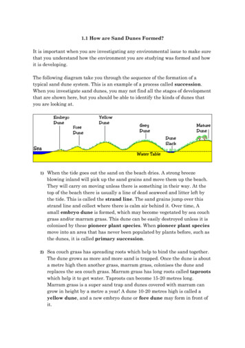
Sand Dune Processes and Management: Part 22.3 Dune morphologyCoastal dune morphology is influenced by several different factors (Figure 2.1)and the scale and form of dune development behind beaches showsconsiderable variation at national and global scales. Dune systems andindividual dune forms can be classified in several different ways, including onthe basis of the environmental setting in which they occur, the broader-scalelandform units of which they are a part (Table 2.1), their basic size and shape,and their genesis (Table 2.2). At the simplest level, dunes may form a singlevegetated ridge at the back of a beach (Figure 2.2), while at the most complexlevel several different types of transgressive and impeded dunes may be existtogether as part of an extensive dune system which may extend a considerabledistance inland, or form a thick vertical sequence which extends below currentsea level.Blowing sand is likely to be deposited wherever there is a reduction in windspeed or a significant increase in surface roughness. This may occur, forexample, in the lee of a topographic obstacle (Plate 2.1), where there is achange in the particle size or bedform roughness of the surface (Plate 2.2), or achange in roughness due to vegetation (Plate 2.3). Development of embryodunes on the backshore of a beach can occur in the absence of vegetation ifthere is a large amount of litter along the drift line, or if the beach is backed by awave-cut dune cliff which favours the development of echo dunes (e.g. Pye,1991). However, development of embryo dunes, and their transformation fromephemeral to permanent features, is favoured by vegetation establishment andsuccession (Plates 2.4 & 2.5). Pioneer vegetation species must normally have adegree of tolerance to saline influence, and be able to withstand relatively highrates of sand deposition (Ranwell, 1972; Kent et al., 2001). Once vegetation isestablished, it exerts a profound influence on the morphology of the foredunewhich subsequently develops (Hesp, 1988a, 1888b, 1989).The nature of the frontal dune morphology on any beach is strongly influencedby the nature of beach-dune sediment exchange (Figure 2.3) and in particularby the balance between the beach and frontal dune sediment budgets (Psuty,1988, 1992; Martinez & Psuty, 2004; Figure 2.4). If the beach sediment budgetis generally negative, embryo dunes will not form and the foredune will undergonet erosion. In extreme circumstances, the foredune will become disrupted byblowouts, leading to the development of transgressive sand sheets and dunes.On the other hand, if the beach sediment budget is positive, the frontal duneswill either grow vertically or prograde seawards though development of newembryo dunes and foredune ridges.On many sections of coast, there is a longshore variation in wave energyconditions and beach/dune sediment budget which is reflected in the dunemorphology (Short & Hesp, 1982; Short, 1988). Figure 2.5 provides a schematicillustration of the longshore variation in dune morphology which can beexpected in an area of unidirectional net littoral drift.The nature of changes which take place in the frontal dune morphology overtime are strongly dependent on the balance between beach and dune sediment2-4
Sand Dune Processes and Management: Part 2budgets. Figure 2.6 illustrates a number of possible changes in dune crosssectional morphology which can arise under differing conditions of beachsediment budget. If there is little or no net gain of loss of sediment from thebeach or frontal dune, the profile is likely to show little change over time(situation a in Figure 2.6). If the dune sediment budget is slightly positive, thenthe dune is likely to grow slowly in height but maintain lateral stability over time(situation b). If the beach and frontal dune sediment budget are both positive,the dune system may be expected to grow seawards over time by developmentof new embryo dunes and foredune ridges (situation c). If the amount of sandremoved from the beach by aeolian and/or marine processes is greater than thesupply of new sand, the dune can be expected to move landwards over timedue to foredune erosion and possible landward movement of transgressivedunes, either maintaining constant height (situation d) or reducing in height(situation e). Examples of stable foredunes are shown in Plates 2.6 & 2.7, whileexamples of prograding systems are shown in Plates 2.8 & 2.9.As noted above, the morphology of individual dunes is often related to thebroader environmental framework within which they occur. Saye (2003)developed a classification of dune system types which extended the ideasoriginally presented by Ranwell & Boar (1986). At the first level of classification,dune systems can be classified on the basis of environmental setting as opencoast, embayment or estuarine types, At a second level of classification, thedune systems can be classified in terms of the major landform type on whichthey occur (e.g. barrier island, spit, tombolo), and various sub-types can beidentified on the basis of other characteristics, such as whether or not thesystem is climbing or non-climbing (Table 2.1). This scheme has been used toclassify each dune system in England and Wales (summarised in Part 3 of thisreport). The plan view and cross-sectional characteristics of the major typesrecognized are illustrated in Figures 2.7a to 2.7c.In the context of coastal flood defence, the morphology of foredunes is often ofparticular significance. Arens & Wiersma (1994) classified Dutch foredunes intoprogressive, stable and regressive types, depending on whether they showedmorphological evidence of seawards accretion, vertical accretion, or landwardsmovement over time. A similar foredune morphological classification scheme(Figure 2.8), developed from a model originally proposed by Pye (1990), wasused in the present study to classify foredunes as stable, eroding or accreting,based on assessments carried out during field visits.2-5
Sand Dune Processes and Management: Part 22.4 Dune responses under storm conditionsDune morphology can be considered to reflect the balance betweenconstructive aeolian processes, which are responsible for dune building, andmarine processes, which may be either constructive or destructive, dependingon the direction of net sediment transport (Figure 2.9). During storms,destructive waves erode sand from the beach, causing levels to fall, and mayalso erode the seaward face of the dunes (Figure 2.10). Increasing stormseverity and/or duration results in progressively greater impact on the dunesystem (Figure 2.11). Under extreme conditions, a dune system may be erodedaltogether, over-topped and flattened, or selectively breached at low points inthe dune ridge (Leatherman, 1979).Dunes which are protected by artificial structures, such as sea walls andrevetments, behave differently during storms to dune frontages which areunprotected. In the former case, a severe storm may cause lowering of thebeach in front of the protection works to the point where it is undermined andexperiences catastrophic failure; no sand can be released from the dunes toreplenish the beach until after the failure has taken place (Figure 2.12). In thesecond situation, unprotected dunes release sand which slows the rate ofbeach lowering; this acts to limit wave energy and slows the rate of frontal duneerosion. During subsequent periods of fair weather, constructive wavestransport sand back on to the beach and aeolian transport processes thenrebuild the frontal dunes. Under ‘ideal’ circumstances, therefore, a dunefrontage provides a naturally dynamic sea defence which requires little or noinitial capital investment and subsequent maintenance. In practice, of course,intervention may be required to rebuild the dune after a major storm event, or aseries of smaller events which occur close together in time, preventing fullnatural recovery of the dune.Storm damage to dune systems often shows considerable longshore variationwhich may reflect variations in the beach and nearshore bathymetry, degree ofwave focussing (Healy, 1987) or in the dune morphology (especially crestheight and width; Figure 2.13). Erosion also need not be restricted to the periodof the marine storm event alone; several significant mechanisms of post-stormerosion exist, including slumping and wind scour from exposed sand faces(Figure 2.14). Intervention measures may be required to prevent or minimisethe effects of these processes, for example by infilling low points in the frontaldune crest line, or by thatching bare sand surfaces created during a storm.If counter-measures are not undertaken, exposed sand areas can quicklydevelop into blowouts and incipient mobile parabolic dunes. Blowouts candevelop either at low points in the frontal dune ridge, which act as wind gapsthrough which airflow is funnelled, or near the crests of high points where baresand has been exposed by cliffing and/or slumping (Jungerius & van derMeulen, 1988; Plate 2.10). Once initiated, blowouts often enlarge through apositive feedback mechanism. The existence of a depression creates additionalturbulence and wind scour which erodes sand from the edges and bottom of theblowout (e.g. Hesp & Hyde, 1996). Evolution of the blowout into a parabolicdune (Plate 2.11) further serves to concentrate the airflow and to accelerate it2-6
Sand Dune Processes and Management: Part 2as it moves up the windward slope of the dune, further enhancing downwindsand transport (Pye, 1982).The rate of erosion of unprotected frontal dunes during storms is governed byseveral factors including tidal height, wave energy, dune height, duration ofstorm and particle size of the sand. Erosion almost always results in cliffing ofthe seaward side of the frontal dune (Plates 2.12 to 2.15).Edelman (1968) found the rate of frontal dune recession in The Netherlandsduring storms was inversely related to the dune height, assuming that sandreleased was uniformly distributed over the foreshore and not immediately lostoffshore. Parker (1975) noted that erosion of the dunes at Formby Point on theSefton coast was most rapid when high tidal levels gave rise to standing waterat the dune foot, causing sand saturation and slumping, in addition to the effectof wave and wave-induced current scour (Figure 2.15). Erosion was found toincrease from c. 1.5 m per tide at a tide height of 9.60 m above Liverpool BayDatum (LBD) to 4.5 - 6 m at levels of 9.75 m LBD. The main factors determiningthe height of wave run-up were found to be beach slope, beach width, dunestoss slope angle, deepwater wave height, wave period and magnitude of thestorm surge component.van de Graaff (1994) concluded from experimental investigations that the rate ofdune erosion during storm surges is largely dependent on six main factors: (1)maximum surge level; (2) significant wave height during (the maximum of) thesurge; (3) particle diameter of the dune material; (4) shape of initial profile(including dune height); (5) storm surge duration; and (6) occurrence of squalloscillations and gust 'bumps' during the storm. The volume of eroded sand andretreat distance as a function of time and other boundary conditions are shownin Figures 2.16 to 2.19.Several computational models have been developed to predict the rate of duneerosion during storm surges. In the model developed by Vellinga (1982, 1983,1986) the input parameters required are: (1) the coordinates of the initial profile;(2) significant deep water wave height; (3) median grain size diameter of dunesand and its corresponding fall velocity for a given water temperature; and (4)maximum water level during the storm surge. Three outputs are obtained fromthe model: (1) the recession of the dune front; (2) the erosion quantity abovestorm surge level; and (3) the beach profile after the storm surge. This modelhas been widely used in the safety assessment and design of Dutch frontaldunes that are required to protect the low-lying hinterland.If there is an interval of several years between major storm events, and if windscour of the cliffed dune face is not too severe, vegetation may naturallyrecolonise the eroded dune slope and begin to trap new sand blown from thebeach (Plate 2.16). The rate of natural advance of the dune front will dependstrongly on the availability of sand for aeolian transport (i.e. on the rate ofnatural beach recovery). This may take several years or not occur at all ifintervention measures are not undertaken (Plate 2.17). In The Netherlands andon the German North Sea coast, beach nourishment and bulldozing are widelyused to encourage beach and dune recovery following storms (e.g. Draga,2-7
Sand Dune Processes and Management: Part 21983). Recovery is also assisted by fencing to keep pedestrians off the dunefront while vegetation becomes re-established (alternative methods of fencingfor different purposes are discussed in Part 4 of this report).2-8
Sand Dune Processes and Management: Part 22.5 Assessment of the flood defence value ofcoastal dunesThe most important attributes of coastal dunes in terms of flood defence are thecrest elevation above mean sea level and the surge level, the geometric shapeand width dimension. The geometries and dimensions of dunes required foradequate protection are determined by storm surge and wave characteristics(Bruun, 1998). Dune systems which have the greatest flood defence value areboth wide and high. In the context of England and Wales, a relatively narrowdune system, 30 to 40
physical nature of sand dune systems, and of sand dune processes, is required. Project objectives The main objectives were: (1) to compile information about the geomorphological and sedimentological character, flood defence significance and management status of coastal dune systems in England and Wales; (2) to