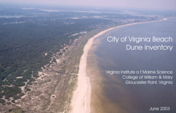
Transcription
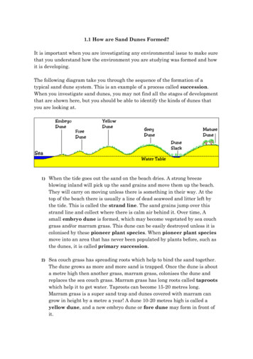
Basic Dune Physical CharacteristicsNew Jersey’s Beach and Dune CharacteristicsDunes in New Jersey are mainly confined to a narrowstrip of land between the beach berm and uplanddevelopment. While there are a few locations in whichthe sand supply and beach width are adequate fordunes to reach their full form (Island Beach State Park,for example) most dunes are limited in height andwidth by the sand available from the beach berm areaand the infrastructure landward of the beach. As aresult, on most New Jersey beaches only a single line ofdunes exists.part of the sandy beach. e line of dunes closest tothe water is called the foredune or primary dune. eseprimary dunes are particularly susceptible to erosion,overwash, and breaching during extreme storms. Duneslocated landward of the foredune are numberedconsecutively and are referred to as the secondary dune,the tertiary dune, and so on. Along developed coasts,the natural dunes are sometimes enlarged withartificially placed sand or replaced altogether with astructure such as a seawall, bulkhead, or revetment. e shape of the beach on any given day is the resultof a complex set of interactions between the air, theland, and the sea. Some of the more important factorsinclude the:Seaward of the dune is the beach berm, which is theflat, dry section of the beach that is normally used byrecreational beach users and by several species ofwildlife and plants. Some of these include rare,threatened, and endangered species. Beyond the bermis a sloped area known as the foreshore which leads intothe water. is foreshore is exposed to constant waveaction and generally shifts shape and slope betweenseasons and storm events in response to changes inwave action. wave heights and water levels experienced atsite during the recent pastpresent wave and water level conditionscharacteristics of the sandunderlying geologic conditions at the sitepresence of any artificial structures. roughout much of New Jersey and the MidAtlantic, present-day dune heights reach 8 to 15 feetabove the flat part of the beach known as the berm(Hamer et al. 1992; Psuty and Ofiara 2002). isheight has been found to be related to the limit of theability of the wind to move sand higher on the duneand deposit it on the back or lee side of the dune(Hamer et al. 1992). Dunes have the potential underideal conditions to grow in height up to 4 feet per year,although growth rates of less than 2 feet per year aremore typical.In a typical beach configuration, known as a beachprofile (Figure 2), the dune is located along the back4 Dune Manual e beach profile continues under water. e areaclosest to the dry sand is called the nearshore. Like theforeshore, the nearshore is constantly affected by theenergy of the breaking waves. e nearshore generallytakes one of two shapes. During calm periods, thebeach slopes off uniformly into deep water andgenerally takes on a characteristic shape known as anequilibrium beach profile (Dean 1977). During stormyperiods, however, sand eroded from the dry beachcollects in nearshore sand bars which form near thepoint at which the majority of the waves are breaking. e part of the beach between the breakpoint and thearea that is constantly dry is sometimes referred to asthe surfzone. e area beyond the breakers is generallyreferred to as the offshore portion of the beach profile.
BackshoreDunesForeshoreN(thro earshoreughbreakers)Berm crestBermsBeachscarpOffshoreLongshoretroughHigh tideLongshorebarsLow tide(dotted line)Figure 2. Example of a typical beach profile.Dunes are constantly changing in response to bothshort- and long-term environmental processes at agiven location. Dunes are sometimes referred to asreservoirs of sand. eir size fluctuates in response tothe amount of available sand on the beach berm, thestrength and duration of the wind, and the storm surgeand wave action. Dunes can either be erosional ordepositional depending on the interaction betweenthese processes. Sand loss from wind- and wavegenerated erosion can impact the dune directly orindirectly by decreasing the supply of sand available tobuild the dune. During large storms, high water levelsmay allow waves to erode the base of the dune andcreate a vertical cut or scarp (Figure 5A, B). Typically,the sand eroded from the dune gets swept into thesurfzone, where it becomes a part of the active littoraltransport system until it is deposited offshore in a baror on a downdrift beach.Winds play an important role as well, with offshorewinds blowing sand from the dune onto the beach,and onshore winds blowing the sand back into thedune. Vegetation plays a critical role both in trappingsand blown towards the dune and in limiting the sandblown off the dune. ese dynamic environmentalconditions cause dunes to shift between erosive andaccretional phases. On many beaches, the dune shiftslandward during the winter in response to erosiveconditions and seaward in the summer in response toaccretional conditions (Figure 3). On a stable coast,the forces building the dune are balanced out by theforces acting to erode the dune.Figure 3. Dune migration due to sand movement from wind.Dune Manual 5
Long-Term Dune EvolutionHistorically, sea level rise has had the greatest impacton the shape of our coastlines. At the end of the lastglacial period (approximately 20,000 years ago), sealevel was about 450 feet lower than it is today, and theshoreline was located approximately 100 miles seawardof its present-day position (Psuty and Ofiara 2002). Asthe earth’s temperature increased and the glaciers beganto melt, sea level rose rapidly and continued to do sountil about 2,500 years ago, when it slowedsignificantly. Geologists generally agree that the barrierisland shoreline of New Jersey at this time was low andnarrow, with poorly developed beaches and dunes thatwere frequently overwashed during large storms (Psutyand Ofiara 2002). During this time the coastallandscape was extremely dynamic. As the rate of sealevel rise decreased to approximately its current rate,the waves and currents began to move the sedimentsthat were originally flooded during the period of rapidsea level rise onto New Jersey’s barrier islands. e rateof sand transfer was sufficient to accumulate largequantities of sediment, increasing the width and heightof the barrier islands (Psuty and Ofiara 2002). As thebarrier islands became more stable, vegetation began togrow and coastal dunes began to develop landward ofthe beach berm (Figure 4). Within the last 500 yearsor so, New Jersey’s barrier islands entered a new phasein their evolutionary development as the oncebountiful supply of offshore sand dwindled, causing atransition from a period of relative stability to one ofgradual loss (Psuty and Ofiara 2002). As surges andlarge waves associated with coastal storms began toinundate the beaches on a more regular basis, thedunes began to erode and migrate landward. Morerecently, human alterations to the environment, suchas shoreline armoring, have further reduced the naturalsupply of sediment to the coast. Without a naturalsource of sediment and to compensate for sandremoved from the system during storms, beaches anddunes struggle to survive.Year 4Year 3Year 2Year 1Figure 4. Dune width and height increase over time and migrate in a seaward direction (Rogers and Nash 2003).6 Dune Manual
StorSmtos rthagenetereaxtetremuregseuragned awae avcetioancticoan cgaennegreaneterbreabrchein tshes.nes.mstthat greanextreesmndvwaateeaschein dutheneduBreacheacs hcanccuorceciutrheritfhrothme lthandidesoider thoer baideysdideepedndin reolnatirevleatievleevealtieovnatioof n ofBrees coanermfroe lasndtheysbaepengndiongthe watewra. teroseioronshioazas swBrre.aBcrheeascharees oanef thoef mt deucstrtivuce tsiho-terrmthenardhazsardasifst wiftre oonethoesmossttrdeve rsthot-teermcurres cntans caredunessinwitay. ay.e dateeepdecehpaneanlsnacssrothses btharrrtheisielan, (Psutyund, e biearrr isdlannandenrmievtehrytghiningitoverwash.swOn isasTtypentvwswexaexistencepencrieeofrmSramndyope voeerodes.dncdunesinedMatolokinlogk, Alongresaulret soulfhowever,stohis tyenat es erxiepeinnMantoiNneg,wNJdevelopedeewseJey seyacoastlines,tSupeof ierinOctobepeninsula,01indication2. Multiplthate beachein Oshorelinesctober o is anMantospacel ingsecdunestion oto shifthe binland,arrier pwhicheninsula,along erodingsandis s formed inlimitedfor’ oastallandscoeape,a e, aandbeingcausetransportedd extensivintoe dathemage to tOnhe communityexposeso dunese torkthe coastal attacklandscand. As iside,oteffsh thaathreatensndrtipoonrtiasoosandrehoinrewiant wascarpingdee dee erosion)ntheo betisheaisctheheispodseipod hooitffsthttshat saisnd itos destroy msresintsa in apermanonentthely lost frothe systesidem. ofOv r dec dunes, t systemnet l (Figuress of s 5A, B). e to stormsulretssultypically depositedcrestandmlandwardrecessioesnsoionhoe sheorselrechionre.eline.ABABFigureerodedby Hurricane Ida in New Jersey. wFigure5B. Erodeddunefrom savewactn dursebasevaesreevsresultingFigur5A.s 8DunesoderdoduneFieguresb.8 rb.ded dunee eseultei sulti m strmonga. nestrong wave action during a severe storm.erodeNeinwNJeerwseJer.se .erode Ida inIdaShort-Term EvolutionSediment Deposition for DuneGrowthWind is the main force responsible for theestablishment, growth, and maintenance of coastaldunes. When a strong wind blows across a sandybeach, it picks up grains of sand which then move bysliding, rolling, or even hopping past one another.Lighter grains of sand are capable of being movedmore easily and can travel farther, while the heaviergrains are left behind. Natural and artificialobstructions on the beach cause the wind to slowdown, which results in depositional areas in selectlocations. On a natural beach, vegetation is the mostcommon obstruction, while on developed beaches,snow fencing or sand fencing is frequently installed tomimic the effect of vegetation and accelerate dunegrowth (Figure 1). e rate at which the wind cansupply sand to a dune depends on the strength of thewind and the availability of a sand source. A beachwith a wide berm typically provides an adequate sandsource and will allow the dune to grow; however, if thebeach is narrow, there may be an insufficient sandsupply, which limits dune growth. On naturallynarrow beaches, beach nourishment projects representan opportunity to encourage dune growth that mightnot occur otherwise.13 13P a gPea g eAs a dune grows, it becomes asymmetrical in shape,with a steep seaward face and a mildly slopinglandward tail. As the dune becomes taller and thevegetation becomes denser, the backdune is shelteredfrom the wind. Under these conditions, growthlandward of the crest is reduced, while seaward of thecrest, growth remains steady. On wide, depositionalcoastlines, it is possible for several distinct dunefeatures to develop. If more than one line of dunesexist, the landward line must be established first.Dune Manual 7
Otherwise the line closest to the shoreline will trapsand, preventing it from reaching the original dune.Generally, the seaward-most dune will continue togrow seaward until the toe of the dune reaches thelandward limit of seasonal beach fluctuations. If thetoe of the dune reaches the mean high water line,beach use for both humans as well as rare, threatened,and endangered species can be inhibited. Healthybeach and dune systems require both a dune and afronting beach, which may require periodic beachnourishment projects in areas where natural sedimentsources have been compromised.Sand Grain Size e size of sand grains on a beach influences the rateof sand transport and dune growth. On a naturalbeach, a given sample of sand will contain particles ofvarying sizes, each of which respond differently to agiven set of wind and wave conditions. Fine-grainsands will move more easily, remain in motion longer,and therefore travel farther than coarse-grain sands. e result is a tendency for wind and waves to sortbeach sediment. Fine-grain sand is more easilyremoved from the beach face and is commonly foundin dunes and offshore in deeper water. Once the initiallayer of fine sand is removed from the beach, theremaining larger grains armor the ground surface,making it more difficult to transport additional sand.Higher wind speeds or larger waves are then requiredA A AB B Bto continue the transport process after the fine surfacematerials have been removed. On most beaches, thesand found at the bottom of the foreshore slope, nearthe location of most intense wave action, is typicallythe coarsest sand.VegetationVegetation is an important part of the evolution ofdunes, as it serves multiple ecological and physicalpurposes. Vegetation slows the wind, causing some ofthe trapped wind-blown sand to settle to the ground. e heavy grains fall out first, as more energy isrequired to keep them suspended. As the wind depositsthe sand, it accumulates around the vegetation,initiating the creation of a new dune or contributingto the growth of an existing one. e accumulatingsand promotes the growth of vegetation uniquelyadapted to dune environments. Both the vegetationand the dune grow in elevation simultaneously as theroots of the vegetation strengthen and help reinforcethe base of the dune. While barriers such as sandfences can recreate the trapping efficiency ofvegetation, they cannot grow with the dunes likevegetation and therefore require maintenance overtime. e most effective dune systems in both promotinghabitat and providing storm protection are those inwhich the appropriate vegetation is encouraged in eachC C CgureFi5gurAmerAmicaneachrasins .b,a,beachgrassc.b, nasodunesn odunen sdunesning nBg nNewBg B Jersey.land,lNand,weeryJs.eerys.ey.Figure 6A, B,FiC.Beach8“CapanBeanass(rAamphiloaphilivgula) a) a)mamryamntspecisepeounnd“Cap“eC” apeAm” Aommomphilbra ocsiuefosndufondononforfoeduns e(os re(ospir(opineeor dunropineezor enezor ne) iNn)eNiwneNse(rfoym(rfomremre re, se, ese, esee e pleaplntieaplntiantingecostienocotinfoothnf eothf etheDune btealisGarassGwtlae tslad sanuigdede) (Fig)u(rFiga-5c).aO-c).sbthalisebhdlise, hdAmee, dAme, Ame B BachBachchGrasrass ws wnt ntunetuteoutaceo tcacoumucacumuclaumueantseand d
growth.g ratesg oratestoo 4 fetoet4pfeest pasos heen oeesne o esde alongalodenngsdeelyncsuelyltivcatpinasavo ofsdunetheongFiguresFi6gura, be.sFigureMulb. 7A,e ulB. Multipleciees cduneantcolo cthatandward landwardsiarded side sidestablsthee altheonglalongthe landw6a,Miespeciess plduneplthatantsplantsthatoeloalcolonizeabld hedof an established dune.dune. dune.While WAmericAmstabelissthabedlisohrepdlaonrtpelad nbtyecdobmmunitiesniotien sduaneBriceachilen uisrallynatuerallyy commuoneduneanhBGeach G ften isftneatalways be consistent with a community’s beachzone. ‘Cape’ American beachgrass (Ammophilasystemsdu,nase gdroprosegsr,emule lstpipeleciesps emsunwetghrowtghrepsrosselst,ipmuoftps lano nciozloizeasareasmanagement plan and should be coordinated with thebreviligulata) is the primary plant species found onlandwalarnddowaf threedufonree.dIunnN, trsyepyic,alugoRsaugoRosaseR(Rurdeoffothe.ewIn JeNersweyJetysppicealciesps eareciesRareosegos(Ruagrososaa),rosa),ENSP to ensure that habitat provisioning is notforedunes (or pioneer zone) in New Jersey (for moreBayberryore(llMa opevani, ancad)GoldeGnrooldde(nrSooldidasp.go) (Figs u6re). sMipleecsiepseacieres areBay(bMerryrensllaylpensyclav)ani, an(Sgoolidasp.u) re(Fig6)u. ltMultsiplecompromised.information, see the dune planting section of thisimportimpantofoner sdutanebiliszas oenacahs pltyapnte hadiffenfftecraepay tcoitrendsandrtrandut fotatibiolnizaatieaacnth pltypseahas aerdint ciatpay toainrestaainguide) (Figure 6A-C). American beachgrass thrives onthrougthrh toherovuendgeta. tiTohestmeffeotsve cdusynsetesmeffetivneeduyssteinmbos itnhbothugirhrtoheir aronodtsaboanvdeagbogrovuendvetigoentaostctin. mTohewindblown sand deposits and collects sparse nutrientsSandin sFencingwehiinchwthihepriaotepromoprtingt abindviditongrmstoprromteprctiooten catireonthochatpprhe oapprpriateomhaotibingtahatapt raondprngovsidiaresethofrom the incoming sand, stimulating growth andSandfencingorsnowfencingisoftenused as a meansvegetationisencouragedineachzone.vegetation is encouraged in each zone.reproduction. American beachgrass establishes quicklyof accelerating or controlling the growth of dunes.and spreads rapidly, making it a favorite amongSand fencing performs a role similar to the stems of9 P 9a gPea g ecommunities undertaking dune restoration projects.the vegetation on a natural beach. By slowing the windTrapping rates of 2 to 4 feet per season have beento a point below that which is required to keep sandobserved along densely cultivated dunes.grains entrained, deposition is encouraged. Sandaccumulates around the base of the sand fence, similarIn natural dune systems, as growth progresses, multipleto the way snow accumulates around a snow fence inspecies of plants will begin to colonize areas landwardcolder climates. Fencings of various materials andof the foredune. In New Jersey, typical species aredensities have been utilized. However, experimentsrugosa rose (Rugosa rosa), bayberry (Morellahave found that the typical wire-bound, wood-slatpensylvanica), and goldenrod (Solidago sp.) (Figure 7A,fencing with a width roughly equal to the spacingB). Species diversity is important for dune stabilizationbetween slats (50% porosity) traps about as much sandbecause each plant type has a different capacity toas other, more costly materials (Manohar and Bruunretain sand through its roots and above-ground1970) (Figure 8A, B). Due to the relative costvegetation. One of the most common mistakeseffectiveness of this type of fencing, it is the type mostcommunities make when undertaking a dunefrequently used in New Jersey.restoration project is planting a single species (mostoften American beachgrass) everywhere within theIn terms of effectiveness, it has been found that sanddune complex. Within the dune system, dense andwill accumulate and eventually reach a level aboutdiverse native herbaceous plants in the appropriatethree-fourths of the exposed height of the sand fencezones can provide habitat to pollinators and other(Hamer et al. 1992), depending on factors such aswildlife. In the beach berm zone, the appropriatelimitation of space and sediment supply. In Dovervegetation is native, herbaceous, and very sparseTownship (now Toms River Township), New Jersey, a( 10% cover). More information on the type of4-foot-tall sand fence placed in a straight line parallelvegetation appropriate for each zone is covered into the ocean was observed to trap concave sandsubsequent chapters; however, dune planting shouldDune Manual 9
about as much sand as other materials (Manohar and Bruun, 9 ) (Figures 7a, b). Due to thet-eecfftievcetinevesneof sthiofncfeingnc,ingis thepe peost ofrsetquefrequereivlateivceoscto-esffrelats osfs thitysptyepoef feit i,sitthentlyntlusyeusd iendNienwNewJersJeersy.ey.B BA AFigure 8A, B. Examplesaccumulation.Figursdunee sandaccuaccumulmatulioatn.ion.Fiofgurs b.fencesb.amwithame uneune s wisthwsitandh sandSand wccuated evtually reeo t three-fourths of the exposed height ofight othisfe-foduneurthsof theDuringexposethed heSanw wideccuand 3.5atefeet dhighev (Herringtontually ree advancingo t thretheseaward.winter,deposits40d feetthe fe fcee ceamer, er,t et 1 12). 2).lt ltughughr sromsoemsube diencrencs tormsngamee hereare some subtle differences inabialibityl,ity,e eostoismt potarta tortoisr is otaol ta. Ge. oGmetmeric tanalyis osis oandandlength of rmcutthe dune toe.Wheresand-trappingability, the imostimportant factoris the l lengththatdepospoitssifop,hiNp,J iNndJ iicndatethattha40t-foo-tfowidwie, d e,e en theleeleoe ofe feng ngn DovDoervTeorwTnshinsdetsfonthenowicate40otfully established dune systems exist, the berm willtotal length of fence in a given area. Studies inplacelacd pearallel toelthtoe thegncvesanddeosform5 foot-higwindblownnc vesandsandde os s form dwardtypicallyt-hherodedigd parallbeback gtoptheseawardline of duneshown thatwhereis an (Haserringtofencen, 20(one4).rowStuaboutdies h40avfeete shown whevegetation.re wind-bl isownseasonalsand isprocessabundant,riseinsgivesto ltheinstallingmuchtwiceicaes mhucfehncn n4 4feeftebenhid tnherstfife) trea) psboaubot twe aicsemaucsahnd,asucmfeencetwiceethibed tfiherstncfeencaapsutictws onlinesmanybehindtwthe first)trapsaboutas much sand,regreardlessohealignmntHr,et.al.,1992).less oalignmenthe alig(Hamernm nt etHal. 1992).r, et. al., 1992). natural beaches (Rogers and Nash 2003) whichregardlessgardof fencelandwardlimitwave-inducedIn NJerJsereys,eysnois friseqfrueutiizeldizetod ctoorepresentntrl doungranae wgiendInewNew, swnofewncfeingncingeqntlueyntly luticoontrlthedeuneowgrtohwatndh eoplewhomightwalkordriveonblown sand. An added benefit is that it creates a barrier to people who might walk or drive onthethedunes. DnipuilatnioinnNJersJeys reisgruleagtebyd tbyhetNmretnmt eonft ldingmanpuiniolatNewinewNewersieyuladteheJ tieocntio(N). heragureadgteopatternst theInNewSeveralcoastaldeployfencingronmenl tanJsand(DENJPDE. Individlsuaalnds acndcomnmuaernce eoncodctoontacoccausentact theNJDNEJDP d-blownsandEP prior to commencing projects intended to create/modify an existing dune. An activitythat is infairly streetcommon foroncoprivateastal communities is the deofplhighoyment oenergy,f seasonalforeshoresnow feslopencingistoflatteneddepositedand/orthat isthefairly common for coastpropertyal communities is the deplowaveyment of setheasonal snowfencingto aslimitthethe amomonths.unt of wind-blownsamaterialnd thatisends up in thsande street anfromd/ortheonbermprivate pmovesropertyduringlimitwinterthe amount oTypically,f wind-bthislownsand that ends up in theerodesstreet and/or on pandrivate prooffshore.pertyduring theonwtheinter moduringnths. theMospring.st comSomemunities simply rTypically,edistribumuchte theofsathendsandon tishestoredbermrelativelyduring close toredistributedbermduring the winter months. Most communities simply redistribute the sand on the berm duringshore in underwater sandbars. If the storms are severecommunities also try to use sand fencing to create10 P a g eenough, the erosion may extend all the 10way acrossdesired dune geometries. By strategically placingP a g ethebeach berm and impact the base of the dunes. isfencing, dune characteristics such as height, width, andcauses an avalanching processes known as beachuniformity can be controlled. Although these practicesscarping, which can result in large vertical cuts in theare not advocated, if they are conducted they shouldseaward dune face. During periods of reduced wavebe included in a community’s beach maintenance planenergy, the New Jersey coast is exposed to smaller, lessand should be coordinated with the NJDEP to ensurefrequent storms and long-period ocean swell thatthat the beach/dune system (including habitattransports sand from offshore back onto the dry beach.provisioning) is not compromised during the process.During this process, the foreshore region is steepenedSeasonal Variabilityand the widest beaches of the season (typically duringOn stable or eroding coastlines, the seasonalthe late summer/early fall) are formed. Overall, thesefluctuation in the beach profile limits the seawardseasonal fluctuations can add up to 75 to 100 feet ofextent of the coastal dune system. Pioneer dune grasseshorizontal and 2 to 5 feet of vertical change.typically encroach on the berm during the summer,10 Dune Manual
Storms and RecoverySmall storms typically only impactthe beach/berm system and leave thePre-storm dune configurationdunes intact. e pre-storm beachPost-storm sand from dunerelocated in waterwidth, elevation, and presence/absence of vegetation will affect theseverity of the erosion experiencedduring a storm. In addition, if theFigure 9. Relocation of sand after a storm.beach has been left vulnerable bynourishments are often utilized as a way to rebuild theprevious storms, increased erosion is likely. In fact, thebeach and accelerate dune recovery.cumulative effects of two closely spaced minor stormscan often exceed the impact of a single severe storm.BreachesDune recession typically only occurs during larger,more infrequent storm events. During these strongstorm events, the berm erodes first, which exposes theforedune to direct wave impact. As the waves erode thebase of the dune, the front face eventually becomesunstable and collapses. During routine storms, most ofthe eroded sand is temporarily stored offshore insandbars that migrate onshore during calm weather. e beach berm can recover to its pre-storm width andelevation in a matter of months. Depending on theextent of the erosion, post-storm dune recovery cantake much longer. While the dune begins to recoveralmost immediately, it typically takes several growingseasons for the beach, dune, and vegetation to returnto pre-storm conditions. In some cases, it has beenfound that full recovery from the most extreme stormscan take up to a decade (Rogers and Nash 2003). Inthe wake of severe storms, emergency beachStorms like Sandy that generate extreme water levelsand intense wave action can generate breaches inundersized sand dune systems. Breaches can occureither from the land side or the bay side, depending onthe relative elevation of the water. On undevelopedcoastlines, breaches and overwash are natural processesthat contribute to barrier island migration and refreshimportant habitats. On developed barrier islands,however, breaches represent one of the mostdestructive short-term erosion hazards as swift currentscan create deep channels capable of carrying awayanything in their paths. During Superstorm Sandy,multiple breaches were formed in the Borough ofMantoloking, resulting in extensive damage to thecommunity (Walling 2015). When they occur indeveloped areas such as Mantoloking, breaches aretypically closed manually through sand placement orstructural means; however, when they occur on naturalcoastlines, breaches may be left to evolve naturally.Dune Manual 11
On many beaches, the dune shifts landward during the winter in response to erosive conditions and seaward in the summer in response to accretional conditions (Figure 3). On a stable coast, the forces building the dune are balanced out by the forces acting to erode the dune. Figure 3. Dune migration due to sand movement from wind. Dune Manual 5