Transcription
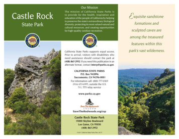
Our MissionCastle RockState ParkThe mission of California State Parks isto provide for the health, inspiration andeducation of the people of California by helpingto preserve the state’s extraordinary biologicaldiversity, protecting its most valued natural andcultural resources, and creating opportunitiesfor high-quality outdoor recreation.Exquisite sandstoneformations andsculpted caves areamong the treasuredfeatures within thisCalifornia State Parks supports equal access.Prior to arrival, visitors with disabilities whoneed assistance should contact the park at(408) 867-2952. If you need this publication in analternate format, contact interp@parks.ca.gov.CALIFORNIA STATE PARKSP.O. Box 942896Sacramento, CA 94296-0001For information call: (800) 777-0369(916) 653-6995, outside the U.S.711, TTY relay le Rock State Park15000 Skyline BoulevardLos Gatos, CA 95030(408) 867-2952 2011 California State Parks (Rev. 2017)park’s vast wilderness.
Castle Rock State Park is a place ofabundant solitude, wilderness, high cliffs,and sweeping vistas. Unique patterns onweathered sandstone, lush forests, andstream-fed canyons make up the park’sdiverse features.From one of the highest ridges in theSanta Cruz Mountains, visitors enjoypanoramic views of Monterey Bay.Encompassing more than 5,150 acres ofwilderness and 34 miles of trails, the parkis popular with rock climbers, hikers, andequestrians. Trails connect to nearby stateparks and open space preserves, expandingvisitor travel from the skyline to the sea.Summer weather is hot and dry. In winter,mountain peaks may be dusted with snow,and temperatures can drop below freezing.CULTURAL HISTORYNative PeopleThe park is located among what once washome to many different tribal communities.Over thousands of years, the tribes ofthe region have come to be collectivelyrecognized as the Ohlone people. Severalareas in this location served their dietaryand spiritual needs. Ohlone visionariesused the massive rocks to connect to theirspiritual world and to acquire personalenlightenment. They also collected a widevariety of plants for medicine and food.Native people hunted deer, pronghorns,and bears that were attracted to the area’sabundant vegetation. Today’s park lies withina major trail system that was used to moveresources inland from the coast.The Smead and Partridge farms werethe largest operations on the ridge, withorchards of apples, pears, walnuts, andgrapes. Near the park’s interpretive shelter,heritage trees planted in the early 1900sstill bear fruit.Castle Rock— one of many sandstoneoutcrops in the parkGold FeverBy 1849, thousands of immigrants hadarrived in California searching for gold. Thenewcomers needed lumber to constructhomes and buildings for new towns. TheSouth Pacific Coast Railroad built new linesfor access between the Santa Cruz mountainsand the Alameda port. By 1884, 28 lumbermills operated in the Big Basin / San LorenzoValley area; the mills yielded more than 34million board feet of lumber each year. Coastredwood made excellent lumber, and tanoakbark was used to tan leather goods. Oncethick forests were rapidly laid bare.AgricultureAgriculture also altered the Castle Rocklandscape for nearly 100 years. Farming,hunting, fishing, and trading made it possiblefor area families to be self-sufficient.Creation of the ParkJudge Joseph Welch of Santa Clara Valleypurchased a 60-acre parcel on CastleRock Ridge in 1908, when logging was stillravaging the hillsides. He established aprecedent by opening his land for thepublic to enjoy its scenic vistas and ruggedlandscapes. With Welch’s determination,Castle Rock soon became a populartourist destination.Dr. Russell Varian, a pioneer of x-ray andradar technology, spent much of his youthexploring and hiking the canyons nearCastle Rock. Varian was the first to measureEarth’s magnetic field, using some sites intoday’s park. In 1959, he secured an optionto purchase this land and planned to donateit to California State Parks. Varian diedbefore completing the purchase. The SierraClub and Sempervirens Fund later donatedthe land in his memory. In July of 1968,Castle Rock was designated a state park.NATURAL HISTORYWildly eroded sandstone formations createprominent ridges in the park’s canyons. Awaterfall fed by natural springs cascades75 feet down the steep mountain slopesto the San Lorenzo River. The river flowingthrough the park provides spawning habitat
for steelhead. Steep trails lead to theunusual rock formations at Varian Peak,Goat Rock, Russell Point, and Castle Rock.GeologyCastle Rock’s famed sandstone outcropsoriginated as submarine fan deposits onthe continental shelf about 30 to 40 millionyears ago. These shelf deposits were thenelevated and moved north by repeatedviolent movements along the tectonicplate boundaries now defined by the SanAndreas Fault. All of the rocks west of thefault line are fundamentally different fromthe rocks on the east side.The uniquely sculpted, rounded rockoutcrops along Castle Ridge have erodedto form pits, pockets, ribs, and ridges.Referred to as tafoni, these erosionalpatterns have endless variations — frompock marks to honeycombed surfaces tolarge concretions and caverns.These complex patterns form withrepeated exposure to erosion from blowingsand, water, and chemical and physicalchanges over eons.Observation deck at Castle Rock FallsVegetationCastle Rock State Park is recovering fromyears of agricultural use and logging thathave caused significant vegetation changes.The park hosts diverse native and non-nativeplant communities: mixed evergreen forest,black oak forest, chaparral, grasslands, andriparian woodland. Spring flowers displaya colorful palette: pink or purple Chinesehouses, lilac slender phlox, deep blue skylupine, pink farewell-to-spring, and goldenelegant madia all thrive on the hillsides.Virgin- and second-growth redwoodsgrow at an unusual elevation, above 2,500feet along Saratoga Gap Trail. Their lowwater supply accounts for these dwarfredwood trees’ uncommonly short 40- to100-foot heights.Climate change affects all living thingswithin the redwood forest. Experts fearthat the area’s increase in averagetemperature and decrease in rain andthick summer fog will endanger redwoodsand other plants and creatures that dependon the redwood environment.Animal lifeWild animals and reptiles seen inthe park include black-taileddeer, gray foxes, coyotes,California newts,mountain lions,and many speciesof snakes.Turkey vultures,red-tailed hawks,acorn woodpeckers,quail, and scrubjays may be spotted.Peregrine falcons maysoar overhead.Peregrine falconFrom Summit Meadows Trail, a view of Monterey Bay in the distance
RECREATIONAL ACTIVITIESCastle Rock State Park is part of aregional trail system linking the parkwith the San Francisco Bay Area andthe Santa Cruz coast. The two majortrail corridors — the Skyline to the Seaand Bay Ridge Trails — lead hikers andbackpackers through steep canyons,dense old-growth redwood forests,creeks, and fields of wildflowers.Picnics —The Partridge Farm site haspicnic tables and an interpretive shelter.Camping —Two trail camps — Castle Rockwith 20 primitive sites and WatermanGap with 6 primitive sites — are available.Both camps have water and pit toilets. Aninclement-weather shelter at Castle RockTrail Camp provides a roof during storms.Hiking and backpacking trails —The park offers 34 miles of nature trails,many with steep and narrow slopes.The Skyline-to-the-Sea Trail connectsCastle Rock and Big Basin RedwoodsState Parks. The 5.6-mile Saratoga Gapand Ridge Trail Loop leads to Goat Rock,Castle Rock Falls, Russell Point Overlook,and the Castle Rock Trail Camp. GoatRock Overlook provides panoramicviews of the San Lorenzo Valley and thePacific Ocean. The moderately difficultRidge Trail is a potential place to seethe endangered peregrine falcon. TheSaratoga Toll Road, a historic logging roadand stagecoach line from 1871, is now awell-shaded and graded hike offeringsome scenic viewpoints.ACCESSIBLE FEATURESThe 0.08-mile accessible path from CastleRock parking lot leads to an ADA-compliantpicnic table with woodland views. Parkingand the pit toilet at the end of the trail mayrequire assistance.Accessibility in state parks is continuallyimproving. For updates, visit the website athttp://access.parks.ca.gov.NEARBY STATE PARKS Big Basin Redwoods State Park21600 Big Basin WayBoulder Creek 95006 (831) 338-8860 Butano State Park1500 Cloverdale RoadPescadero 94060 (650) 879-2040 Portola Redwoods State Park9000 Portola State Park RoadLa Honda 94020 (650) 948-9098PLEASE REMEMBER Park hours: open from 6 a.m. to sunset,including all trails. Only campers registeredin backpack trail camps may remain in thepark overnight. Dogs (except for service animals), glasscontainers, and smoking are prohibitedthroughout the entire park. Bicycles may be ridden only on the Skylineand Service Road trails. Horses are permitted on designatedequestrian trails only. Please check themap before your ride. Firearms or any device capable of harmingany person or animal are prohibited —including BB guns, spears, bows, arrows,and slingshots. Fires are permitted only in designated firerings in the Castle Rock Trail Camp during theOFF fire season. Gathering firewood, includingtwigs and leaves, is prohibited. Firewood issold at the Castle Rock Trail Camp. Quiet hours are 10 p.m. to 6 a.m. daily. Please respect private property rights andstay on designated trails. All natural and cultural features are protectedby law. Do not pick wildflowers, mushrooms,or other plants, or remove any park feature.Do not feed, disturb, or harm wildlife. Beware of rattlesnakes, ticks, and poison oakin camp and on trails.This park is supported in part throughPortola and Castle Rock Foundationwww.portolaandcastlerockfound.org
ROCK CLIMBINGCastle Rock State Park provides apopular site to hike and rock climb.Climbers have scaled the park’soutcrops of Vaqueros sandstone —Castle Rock and Goat Rock — for nearlya century. The sandstone’s relativelyhard exterior and unique tafonipatterns are ideal for boulderingand rock climbing.To preserve the character of theseunique rock formations and minimizethe impact on soils, vegetation, wildlife,other climbers, and visitors, Castle Rock State Parkrequires low-impact climbing and supports “Leave No Trace”practices. Properly dispose of all trash and protect the park’snatural resources.Observe all park rules and closures — Climbing and otheroff-trail activities are not permitted in the San LorenzoHeadwaters Natural Preserve. Check park bulletin boardsbefore climbing for notice of possible restrictions to protectnesting birds, other wildlife, and areas recovering from overuse.Limit bolting — Before placing new bolts or replacing old ones,climbers are required to notify the park and receive approval.Please contact the park in advance to initiate a request for bolting.Help prevent erosion — Use only existing access trails. Pleasecarry (rather than drag) crash pads. The park’s topsoil is fragileand easily displaced from the steep slopes in much of the park.Protect park vegetation — The plants and trees provide foodand shelter for wildlife. Please avoid damaging mosses, lichens,and branches.Respect the integrity of the rock and the climb — Please do notchip, glue, remove, or otherwise alter the rock. Please allow two orthree days after a heavy rain before climbing. Sandstone becomesmuch more fragile when damp.Rock climbing classes — Ropes classes and similar activities(whether held by private, educational, nonprofit, or commercialgroups) require advance permits and insurance. For permitapplications, call (408) 867-2952.
24Unpaved RoadSaLONG RIDGEO P E N S PA C EP R E S E RV EButanoSP000024Traild14CASTLEBCng sSp r i2600Trail0260ea-S9Gaeto3502600Sk400 Feet0100 Meters85 and 17ylineTrailtoMain ParkEntranceS a r atogaGoat RockOverlookE0.40.60.5 Miles0.8 UPPERSerDO261200800 Feet50 100 150 200 250 MetersperGu lch1600180024002200160000RidgeTrailP R I V AT EP R O P E RT Y00000Slee26600200020000000140018400200000D eer Creek24001820RIDGE240037 14’ 00”00GERIDCKB00TTra000en zhry WoodsLogFrog Flat TrailoadTrlTollRatogaS ar26016o R iver00P R E S E RV EMcDonaldGulchELor30N AT U R A L000018San1600PSeagraves ParkingP R I V AT EP R O P E RT YUCKT B1400toBoulderCreek 122 08’ 30”to 17via Black RoadFA0Sarato g a Gap Tr ailP00H E A D WAT E R STRAIL CAMPAREAInclementWeather Shelter240000Bittles Parking353231ft985mCASTLE ROCK18192200to28Skyidge Trail)line Trail (Bay Area RMt. Bielawski(Mt. McPherson)28kMCek11Cr e122 09’ 00”CastleRock1800e RoadTrvicailSANBORNSKYLINECOUNTYPA R K3214ft980mUre eKisC1635gs00to Big BasinState ParkMain 12222125 24 2023514 3280toilK in10236Traila GapatogSar1716 1514 13Camp10000CastleRockTrailIDGDAMOND Rkngs CreeSpriaigCr2200800P R I V AT EP R O P E RT YCastle FallsRock OverlookFallsTr a i l2000ng0018a/-Serail-th e ect o r T-tonnne rcoS k yli nteToll R o ad IIndianRockpSAN LORENZO00149a Gatog320000WatermanGap TrailCampraSa37 13’ 00”BALERGap00DKGGoatRock2200DCIDPk37 13’ 00”24001000rMain ParkEntrance3000ee122 08’ 00”122 07’ 30”122 07’ 00”122 06’ 30”122 06’ 00”122 05’ 30”122 05’ 00”122 04’ 30”37 12’ 30”2600tone con ailTrP R I V AT EP R O P E RT Y00Cr37 13’ 30”28873m000PeakG E Varian2865ftdTod03024RID2037 13’ 00”280000LETrail220037 13’ 30”th2426eTraap00dT937 13’ 0CASaPA R KRussellPoint00Waterman Gap ParkingSkyliP35PartridgeFarm10P R I V AT EP R O P E RT Y122 09’ 30”85 and 17S A R AT O G AGAP AREAMcElroyRdIntercs16TraSummit RockSummitRockTrailsee detailmap below1800aSaratogaGaptoWatermanPGapCampSummit Rock ParkingS TAT E160000P R O P E RT Y120toPSer vice R o a dl1437 12’ 30”TraildsooCastle RockTrail CampCraig S p gs CreekrinSA12WatermanGapk0Sa r atyWo g hrrail140e -SeaTraiP R I V AT Esee detail mapaboveee00oga240ne Springs Trail18a To l l RS a r a t og100Skyline-to-thPCr20002200SanTkhoa200 M00kerooC ra i gRiverzoenl)ekLoop160000t he-18001600reP R I V AT EP R O P E RT Y001200NutmSky line-t o-t he -SeaSummitMeadowsTrail37 15’ 00”37 14’ 30”TrailGap12001691800R idge1837 14’ 00”1800e r tito SantaCruz02600avTrCui9800 Ft100aP R I V AT EP R O P E RT YNote: Pleasestay on trailin this area.rScottsValleyHenry CowellRedwoods SPWilder RanchSPNS A R AT O G AGAPO P E N S PA C EP R E S E RV 035P R I V AT EP R O P E RT YRoad Trailoll1200oic e RServlltoSantaCruz0PEAROCKee6WatermanGap TrailCamp9160aOld Corral Parking17 2011 California State Parks (Rev. 2017)see detail maplower ga Toll RLoTin2 3 4PPSarato g aee-S-th-toneOCPLong Ridge24Red MountainParking9PBoulderCreekto Santa CruzaTr2000railSea T2000BIGBASINS P ilICLosGatos359Ben - t o -the-SeaTraill240Trailege20to -TraiRed MountainOverlook0022002000ryAyline Trail (B aSk0WaterfalleylinSk000180P R I V AT EP R O P E RT YMountain9Saratoga18160Telephone1200IF02200Hwy 9 TurnoutRedRestrooms236160PInformationtoBig BasinSP HQ9to LosAngelesSaratoga18Achistaca0037 15’ 30”SaratogaGapAñoNuevoSP2000TrailParking85236to SanBigFrancisco BasinRedwoods SP88028035Castle Rock SPFire StationLocked Gate6 Km4PortolaRedwoodsSPS A R AT O G A G A PO P E N S PA C EP R E S E RV E16002State ParkHorse Staging AreaPicnic Area122 04’ 30”San Joséto SanFrancisco 2804 Mi20CPACampground(not athroughroad)122 05’ 00”Castle RockratogAccessible FeatureMi122 05’ 30”lTraiapaGTrail: AccessibleWAT E R M A NGAP TRAILCAMP AREA122 06’ 00”000002637 16’ 00”26Trail: Multi-Use122 06’ 30”37 16’ 00”35Paved RoadTrail: Hike & Horse122 07’ 00”pTra ilMajor RoadTrail: Hike122 07’ 30”37 15’ 30”122 08’ 00”37 15’ 00”122 08’ 30”84 and 9200to37 14’ 30”122 09’ 00”22122 09’ 30”Legend
Castle Rock and Big Basin Redwoods State Parks. The 5.6-mile Saratoga Gap and Ridge Trail Loop leads to Goat Rock, Castle Rock Falls, Russell Point Overlook, and the Castle Rock Trail Camp. Goat Rock Overlook provides panoramic views of the San Lorenzo Valley and the Pacific Ocean. The moderately difficult Ridge Trail is a potential place to see