Transcription
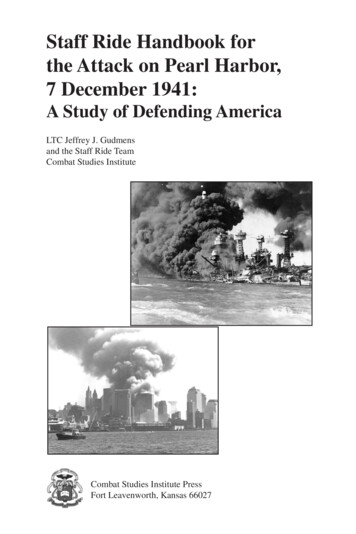
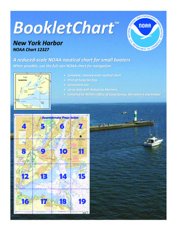
BookletChart New York HarborNOAA Chart 12327A reduced-scale NOAA nautical chart for small boatersWhen possible, use the full-size NOAA chart for navigation.
Published by theNational Oceanic and Atmospheric AdministrationNational Ocean ServiceOffice of Coast Surveywww.NauticalCharts.NOAA.gov888-990-NOAAWhat are Nautical Charts?Nautical charts are a fundamental tool of marine navigation. They showwater depths, obstructions, buoys, other aids to navigation, and muchmore. The information is shown in a way that promotes safe andefficient navigation. Chart carriage is mandatory on the commercialships that carry America’s commerce. They are also used on every Navyand Coast Guard ship, fishing and passenger vessels, and are widelycarried by recreational boaters.What is a BookletChart ?This BookletChart is made to help recreational boaters locatethemselves on the water. It has been reduced in scale for convenience,but otherwise contains all the information of the full-scale nauticalchart. The bar scales have also been reduced, and are accurate whenused to measure distances in this BookletChart. See the Note at thebottom of page 5 for the reduction in scale applied to this chart.Whenever possible, use the official, full scale NOAA nautical chart fornavigation. Nautical chart sales agents are listed on the Internet athttp://www.NauticalCharts.NOAA.gov.This BookletChart does NOT fulfill chart carriage requirements forregulated commercial vessels under Titles 33 and 44 of the Code ofFederal Regulations.Notice to Mariners Correction StatusThis BookletChart has been updated for chart corrections published inthe U.S. Coast Guard Local Notice to Mariners, the National GeospatialIntelligence Agency Weekly Notice to Mariners, and, where applicable,the Canadian Coast Guard Notice to Mariners. Additional chartcorrections have been made by NOAA in advance of their publication ina Notice to Mariners. The last Notices to Mariners applied to this chartare listed in the Note at the bottom of page 7. Coast Pilot excerpts arenot being corrected.For latest Coast Pilot excerpt visit the Office of Coast Survey website hart.php?chart 12327(Selected Excerpts from Coast Pilot)Sandy Hook, the southern entrance point toNew York Harbor, is low and sandy. A CoastGuard station, a radar tower, and a radiotower are near the northern extremity ofSandy Hook. The towers and a large greenstandpipe to the southeast are the mostprominent objects on the northern end ofSandy Hook. Southward of the standpipe areseveral houses and Sandy Hook Light(40 27'42"N., 74 00'07"W.), 88 feet abovethe water and shown from a white stone tower, 85 feet high. This light,established in 1764, is the oldest in continuous use in the United States.New York Harbor is the principal entrance by water to New York Cityand the surrounding ports. The harbor is divided by The Narrows intoLower Bay and Upper Bay. The Battery, the southern tip of Manhattan,is at the junction of East River and Hudson River. The main channel fromthe sea to the deepwater terminals in Hudson River has a project depthof 45 feet.In addition to the usual aids, Ambrose Channel in its outer portion is alsomarked by West Bank Light, shown from a brown conical tower on ablack cylindrical pier, in range with Staten Island Light, which is shownfrom a light-colored octagonal brick tower on a gray limestone base onthe high ground of Staten Island at Richmond.Sandy Hook Channel, project depth 35 feet, provides a secondary routefrom the sea to deep water in Lower Bay; it connects with Raritan BayChannel to the westward, Chapel Hill Channel to the north, andTerminal Channel to the south. Chapel Hill Channel has a project depthof 30 feet. The entrance to Sandy Hook Channel is marked by ScotlandLighted Horn Buoy S, equipped with a radar beacon (Racon). Thechannels are well marked with navigational aids.Swash Channel, a natural buoyed passage between Ambrose Channeland Sandy Hook Channel, has a controlling depth of 18 feet, but care isnecessary to avoid spots with a least depth of 13 feet near the sides ofthe channel and a spot cleared to a depth of 14 feet in about the middleof the channel. A lighted range, the rear marker of which is Staten IslandLight, leads on a bearing of 305 to the junction with Chapel HillChannel.Caution.–Telegraphic companies report serious interruptions ofinternational telegraphic communications resulting from repeatedbreaking of their cables by vessels anchoring southeastward andeastward of the Pilot Cruising Area for Ambrose and Sandy Hookchannels. The companies state that they will be glad to compensate anyvessel, which, having fouled the cable, cuts away its anchor and chain inorder to save the cable from interruption. Vessels making New York inthick weather and finding it necessary to anchor before enteringAmbrose Channel should anchor in the area southward of ScotlandLighted Whistle Buoy S (40 26'33"N., 73 55'01"W.) and westward of73 48’00”W.Caution.–Numerous fishing floats reported in the approach to NewYork Harbor in the Traffic Separation Scheme precautionary area.Physical Oceanographic Real-Time System (P.O.R.T.S.) is aninformation acquisition and dissemination technology developed byNational Ocean Service, NOAA. The Port of New York and New JerseyPhysical Oceanographic Real-Time System can be contacted viatelephone 866-217-6787 or the Internet at: http://www.coops.nos.noaa.gov.Dangers.–There are five shoal areas in the entrance to New York Harborwhich are subject to change in depths and should be avoided bystrangers. False Hook is off the northeastern side of Sandy Hook. FlynnsKnoll is between Swash, Sandy Hook, and Chapel Hill Channels. RomerShoal, between Ambrose and Swash Channels, is marked by RomerShoal Light; a fog signal is sounded from the light station. East Bank isnorthward and eastward of Ambrose Channel. West Bank is westwardof Ambrose Channel between West Bank (Range Front) Light and FortWadsworth. Numerous rocks and obstructions lie between West Bankand the western limit of Ambrose Channel. The chart is the best guide.The tip of Sandy Hook is changeable, and the area around it is subjectto severe shoaling; caution should be exercised in the area.Mariners are cautioned to maintain a sharp lookout for floating debrisin the harbor and channels.U.S. Coast Guard Rescue Coordination Center24 hour Regional Contact for EmergenciesRCC Boston2Commander1st CG DistrictBoston, MA(617) 223-8555
Lateral System As Seen Entering From Seawardon navigable waters except Western RiversPORT SIDEODD NUMBERED AIDSGREEN LIGHT ONLYFLASHING (2)FLASHINGOCCULTINGQUICK FLASHINGISOPREFERRED CHANNELNO NUMBERS – MAY BE LETTEREDPREFERRED CHANNELNO NUMBERS – MAY BE LETTEREDPREFERRED CHANNEL TOSTARBOARDTOPMOST BAND GREENPREFERRED CHANNELTO PORTTOPMOST BAND REDGREEN LIGHT ONLYRED LIGHT ONLYFLASHING (2)FLASHINGOCCULTINGQUICK FLASHINGISORED LIGHT ONLYCOMPOSITE GROUP FLASHING (2 1)COMPOSITE GROUP FLASHING (2 1)812"1"Fl G 6sLIGHTGR "A"Fl (2 1) G 6sG "9"Fl G 4s5DAYBEACON"2"Fl R 6sRG "B"Fl (2 1) R 6sG"5"UCGR"U"RGN "C"GRC "S"CANG6RG"G"NUNFor more information on aids to navigation, including those on Western Rivers, please consult the latest USCG Light List for your area.These volumes are available online at http://www.navcen.uscg.govRN "6"NUNR "8"Fl R 4sLIGHTED BUOYLIGHTLIGHTED BUOYGC "1"CANSTARBOARD SIDEEVEN NUMBERED AIDS2DAYBEACONR"2"
VHF Marine Radio channels for use on thewaterways:Channel 6 – Inter-ship safety communications.Channel 9 – Communications between boats andship-to-coast.Channel 13 – Navigation purposes at bridges, locks, andharbors.EMERGENCY INFORMATIONChannel 16 – Emergency, distress and safety calls toCoast Guard and others, and to initiate calls to othervessels. Contact the other vessel, agree to another channel, and then switch.Channel 22A – Calls between the Coast Guard and the public. Severe weatherwarnings, hazards to navigation and safety warnings are broadcast here.Channels 68, 69, 71, 72 and 78A – Recreational boat channels.Distress Call Procedures Make sure radio is on. Select Channel 16. Press/Hold the transmit button. Clearly say: “MAYDAY, MAYDAY, MAYDAY.” Also give: Vessel Name and/or Description;Position and/or Location; Nature ofEmergency; Number of People on Board. Release transmit button. Wait for 10 seconds — If no responseRepeat MAYDAY call.Getting and Giving Help — Signal other boaters using visual distress signals (flares,orange flag, lights, arm signals); whistles; horns; and on your VHF radio. You arerequired by law to help boaters in trouble. Respond to distress signals, but do notendanger yourself.HAVE ALL PERSONS PUT ON LIFE JACKETS!NOAA Weather Radio All Hazards (NWR) is a nationwide network of radio stations broadcasting continuousweather information directly from the nearest National Weather Service office. NWR broadcasts official WeatherService warnings, watches, forecasts and other hazard information 24 hours a day, 7 days a week.http://www.nws.noaa.gov/nwr/Quick ReferencesNautical chart related products and information - http://www.nauticalcharts.noaa.govQRInteractive chart catalog - .shtmlReport a chart discrepancy - hart and chart related inquiries and comments - page ContactUsChart updates (LNM and NM corrections) - http://www.nauticalcharts.noaa.gov/mcd/updates/LNM NM.htmlCoast Pilot online - htmTides and Currents - http://tidesandcurrents.noaa.govMarine Forecasts - http://www.nws.noaa.gov/om/marine/home.htmNational Data Buoy Center - http://www.ndbc.noaa.gov/NowCoast web portal for coastal conditions - http://www.nowcoast.noaa.gov/National Weather Service - http://www.weather.gov/National Hurrican Center - http://www.nhc.noaa.gov/Pacific Tsunami Warning Center - http://ptwc.weather.gov/Contact Us - tmFor the latest news from Coast Survey, follow @NOAAchartsThis Booklet chart has been designed for duplex printing (printed on front and back of one sheet). If a duplex optionis not available on your printer, you may print each sheet and arrange them back-to-back to allow for the properlayout when viewing.NOAA’s Office of Coast SurveyThe Nation’s Chartmaker
NOAA Chart 12327 . A reduced -scale NOAA nautical chart for small boaters When possible, use the full -size NOAA chart for navigation. 2 P ublished by the . . Lighted Horn Buoy S, equipped with a radar beacon (Racon). The channels are well marked with navigational aids.