Transcription
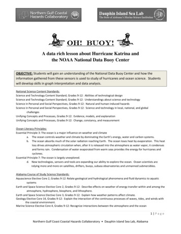
Oh! Buoy!A data rich lesson about Hurricane Katrina andthe NOAA National Data Buoy CenterOBJECTIVE: Students will gain an understanding of the National Data Buoy Center and how theinformation gathered from these sensors is used to study of hurricanes and ocean science. Studentswill develop skills in graph interpretation and data analysis.National Science Content Standards:Science and Technology Content Standard, Grades 9‐12: Abilities of technological designScience and Technology Content Standard, Grades 9‐12: Understandings about science and technologyScience in Personal and Social Perspectives, Grades 9‐12: Natural and human‐induced hazardsScience in Personal and Social Perspectives, Grades 9‐12: Science and technology in local, national, and globalchallengesUnifying Concepts and Processes, Grades 9‐12: Evidence, models, and explanationUnifying Concepts and Processes, Grades 9‐12: Change, constancy, and measurementOcean Literacy Principles:Essential Principle 3: The ocean is a major influence on weather and climatea. The ocean controls weather and climate by dominating the Earth’s energy, water and carbon systems.b. The ocean absorbs much of the solar radiation reaching Earth. The ocean loses heat by evaporation. This heatloss drives atmospheric circulation when, after it is released into the atmosphere as water vapor, it condensesand forms rain. Condensation of water evaporated from warm seas provides the energy for hurricanes andcyclones.Essential Principle 7: The ocean is largely unexplored.d. New technologies, sensors and tools are expanding our ability to explore the ocean. Ocean scientists arerelying more and more on satellites, drifters, buoys, subsea observatories and unmanned submersibles.Alabama Course of Study Science Standards:Aquascience Elective Core 2, Grades 9‐12: Relate geological and hydrological phenomena and fluid dynamics to aquaticsystemsEarth and Space Science Elective Core 2, Grades 9‐12: Describe effects on weather of energy transfer within and among theatmosphere, hydrosphere, biosphere, and lithosphere.Earth and Space Science Elective Core 3, Grades 9‐12: Explain how weather patterns affect climate.Geology Elective Core 14, Grades 9‐12: Explain the interaction of the continuous processes of waves, tides, and winds withthe coastal environment.Marine Science Elective Core 4, Grades 9‐12: Recognize interactions between the atmosphere and the ocean1 PageNorthern Gulf Coast Coastal Hazards Collaboratory Dauphin Island Sea Lab, Alabama
Oh! Buoy!BACKGROUND INFORMATIONABOUT THE NATIONAL DATA BUOY CENTER:From the NOAA National Data Buoy Center http://www.ndbc.noaa.gov/tour/virtr1.shtmlThe National Oceanic and Atmospheric Administration (NOAA) National Data Buoy Center (NDBC) is apart of the National Weather Service (NWS). NDBC designs, develops, operates, and maintains anetwork of data collecting buoys and coastal stations. NWS forecasters need frequent, high‐qualitymarine observations to examine conditions for forecast preparation and to verify their forecasts afterthey are produced. Other users rely on the observations and forecasts for commercial and recreationalactivities. NDBC provides hourly observations from a network of about 90 buoys and 60 Coastal MarineAutomated Network (C‐MAN) stations to help meet these needs. All stations measure wind speed,direction, and gust; barometric pressure; and air temperature. In addition, all buoy stations, and someC‐MAN stations, measure sea surface temperature and wave height and period. Conductivity (used toderive salinity) and water current are measured at selected stations.NDBC's main office is located in southern Mississippi at theStennis Space Center, a National Aeronautics and SpaceAdministration (NASA) facility. This site was chosen because itcontains an excellent pre‐existing industrial facility which isadjacent to a canal with deep‐water access to the Gulf ofMexico. Equipment integration and testing aboard the buoysare accomplished in high bays. Sensors are calibrated in windtunnels or environmental chambers, and later tested with theonboard station microprocessors, called payloads, on teststands at the outside sensor test facility. Final calibration andtesting of the completed buoy systems are accomplished inthe onsite canals. Most NDBC stations are located at sitesdetermined by NWS forecast and warning requirements.Some are installed and maintained in areas identified throughreimbursable funding agreements with other agencies andprivate sector institutions. The NDBC web site provides ahistorical inventory of measurements made at each NDBCstation.All buoys and many C‐MAN stations located in offshore areas operate on marine batteries which arecharged by solar cells. Data collection, averaging, and formatting for satellite transmissions arecontrolled by a payload computer system. On buoys, the payloads and batteries are located inside thehull; on C‐MAN stations, they are located at the base of the tower.2 PageNorthern Gulf Coast Coastal Hazards Collaboratory Dauphin Island Sea Lab, Alabama
NDBC uses commercially available sensors such as anemometers to measure wind speed and directionand barometers to measure atmospheric pressure. On the buoys, wave data are collected using anaccelerometer which measures the vertical acceleration every 2/3 of a second for 20 minutes. Waveheights and periods are mathematically calculated from these time‐series accelerations.Offshore servicing relies primarily on support from the United States Coast Guard. Stations are servicedas required to repair damaged or degraded equipment. In addition, all buoys are serviced about every2 years for routine maintenance and to install newly calibrated sensors. The Great Lakes buoys areretrieved every fall because of potential damage by ice. Moorings are designed for a 6‐year life span,but often last up to 10 years. The type of mooring used depends on the hull type, location, and waterdepth.The observations from moored buoys and C‐MAN stations are transmitted hourly through NOAAGeostationary Operational Environmental Satellites (GOES) to a ground receiving facility at WallopsIsland, VA, operated by the NOAA National Environmental Satellite, Data, and Information Service(NESDIS). Some stations report via commercial low earth orbiting satellites. The satellite reports areimmediately relayed to the NWS Telecommunications Gateway (NWSTG) in Silver Spring, MD.NDBC also serves as a data assembly center for receiving, quality controlling, and disseminatingmeasurement data from other stations owned and maintained by non‐federal regional oceanobserving systems, members of the U.S. Integrated Ocean Observing System (IOOS).At the NWSTG, NDBC systems perform automated quality control on the reports. Data analysts atNDBC monitor the data and adjust the controls to release only good quality data. From the NWSTG, thedata are transmitted via various communications networks to NDBC and NWS offices. Privatemeteorologists receive the reports via the NWS Family of Services. The general public receives them viathe Internet, via Dial‐A‐Buoy, and via NOAA Weather Radio. After additional quality analysis, NDBC3 PageNorthern Gulf Coast Coastal Hazards Collaboratory Dauphin Island Sea Lab, Alabama
data are transmitted to NOAA's archive centers, the National Oceanographic Data Center, NODC, andthe National Climatic Data Center, NCDC.HURRICANESFROM HTTP://WWW.NHC.NOAA.GOV/CLIMO/ AND s are a type of tropical cyclone. A tropical cyclone is a rotating, organized system of cloudsand thunderstorms that originates over tropical or subtropical waters and has a closed low‐levelcirculation. Tropical cyclones rotate counterclockwise in the Northern Hemisphere. They are classifiedas follows: Tropical Depression: A tropical cyclone with maximum sustained winds of 38 mph (33 knots) orless. Tropical Storm: A tropical cyclone with maximum sustained winds of 39 to 73 mph (34 to 63knots). When a cyclone becomes a tropical storm, it is given a name by the WorldMeteorological Organization. (To see a current list of cyclone names for the next 6 years, visithttp://www.nhc.noaa.gov/aboutnames.shtml) Hurricane: A tropical cyclone with maximum sustained winds of 74 mph (64 knots) or higher. Inthe western North Pacific, hurricanes are called typhoons; similar storms in the Indian Oceanand South Pacific Ocean are called cyclones. Major Hurricane: A tropical cyclone with maximum sustained winds of 111 mph (96 knots) orhigher, corresponding to a Category 3, 4 or 5 on the Saffir‐Simpson Hurricane Wind Scale.Retired storm names: http://www.nhc.noaa.gov/aboutnames history.shtml4 PageNorthern Gulf Coast Coastal Hazards Collaboratory Dauphin Island Sea Lab, Alabama
Hurricanes are low pressure systems that can pack wind speeds of over 160 miles (257 kilometers) anhour and unleash more than 2.4 trillion gallons (9 trillion liters) of rain a day. Hurricanes begin astropical disturbances in warm ocean waters with surface temperatures of at least 80 degreesFahrenheit (26.5 degrees Celsius). These low pressure systems are fed by energy from the warm seas.Hurricanes are enormous heat engines that generate energy on a staggering scale. They draw heatfrom warm, moist ocean air and release it through condensation of water vapor in thunderstorms.Hurricanes spin around a low‐pressure center known as the “eye.” Sinking air makes this 20‐ to 30‐mile‐wide (32‐ to 48‐kilometer‐wide) area notoriously calm. But the eye is surrounded by a circular“eye wall” that hosts the storm’s strongest winds and rain.These storms bring destruction ashore in many different ways. When a hurricane makes landfall itoften produces a devastating storm surge that can reach over 20 feet (6 meters) high and extendnearly 100 miles (161 kilometers). Ninety percent of all hurricane deaths result from storm surges. Ahurricane’s high winds are also destructive and may spawn tornadoes. Torrential rains cause furtherdamage by spawning floods and landslides, which may occur many miles inland.The best defense against a hurricane is an accurate forecast that gives people time to get out of itsway. The National Hurricane Center issues hurricane watches for storms that may endangercommunities, and hurricane warnings for storms that will make landfall within 24 hours.The Atlantic hurricane season runs from June 1st to November 30th but peaks from mid‐August to late Octoberand averages five to six hurricanes per year. The Atlantic basin includes the Atlantic Ocean, Caribbean Sea, andGulf of Mexico.5 PageNorthern Gulf Coast Coastal Hazards Collaboratory Dauphin Island Sea Lab, Alabama
NDBC Data UsesSurveys of meteorologists have shown about 40 percent of NWS marine warningsand advisories are based, at least in part, on NDBC's meteorological data. Inaddition to this critical purpose, the observations are used by meteorologists whoneed to adjust flight level wind speeds reported by hurricane reconnaissanceaircraft to surface winds; by geophysicists who use our sea surface temperature,wind, and wave reports to help calibrate remotely sensed measurements fromspacecraft; and by engineers who obtain directional wave measurements to study beacherosion and shore protection. Surfers, fishermen, and boaters acquire the reports via theInternet to help them determine if they want to venture offshore.FOR THIS ACTIVITYThis lesson can be done without the use of a student computer lab.Discuss the National Data Buoy Center with your students. If the teacher has internet access, visithttp://www.ndbc.noaa.gov/ and visit several buoy sites in the Gulf of Mexico and around the world.Discuss the ongoing real‐time data that is collected by the buoys and show several examples such asthe information found at the Gulf of Mexico station 42003.(http://www.ndbc.noaa.gov/station page.php?station 42003)Students will need a basic understanding of how to read scientific data from graphs prior to doing thisexercise, including x‐axis versus y‐axis, dependent and independent variables, and interpretting datatrends.This lesson assumes a general knowledge of hurricanes and the parts of a wave (period, wave height,and wave length).Expand it!In a computer lab, have your students visit the NDBC website and locate NDBC sation 42040. Comparethis week’s data to the data during hurricane Katrina. Compare and contrast the maximum sustainedwave heights, maximum wind gusts, wind speed, air pressure and atmospheric pressure. To the left ofeach current measurement, students can click on the graph icon to see time series plots of the datafrom the past five days.6 PageNorthern Gulf Coast Coastal Hazards Collaboratory Dauphin Island Sea Lab, Alabama
Oh! Buoy!STUDENT WORKSHEET TEACHER KEYHurricane Katrina was a Category 4 tropical cyclone when it struck land in 2005. The hurricane’sintensity reached a maximum wind speed of 175mph making it the second strongest hurricane ever recorded inthe Gulf of Mexico. National Data Buoy Center information was gathered throughout the Atlantic Ocean andGulf of Mexico as the storm traveled its path.Using the figure and graphs, answer the questions about Hurricane Katrina and NDBC ocean science data.Don’t forget to include the correct unit of measurement in your answers!FIGURE 1: The track ofHurricane Katrina’s eyefrom August 24‐ August29, 2005.The start of each day isnumbered. NationalData Buoy locations aredesignated by squaresand labeled with thestation numbers.Locate NDBC station 42040.1. What is the approximate latitude and longitude of NDBC station 42040? 29⁰N 88.5⁰W2. What day did the eye of Hurricane Katrina pass NDBC station 42040? AUGUST 29, 20053. Where is buoy 42040 located in respect to Katrina’s path? APPROXIMATELY 1.5⁰ EAST OF THE STORM EYEIf 1⁰ longitude at 30⁰N equals approximately 59.95 miles, how far away was station 42040 from theeye’s center? APPROXIMATELY 89.9 MILES4. How did the path of Hurricane Katrina change between August 28 and August 29? 8‐28 TRAVELEDNORTHWEST, 8‐29 DIRECTION SHIFTED TO THE NORTH7 PageNorthern Gulf Coast Coastal Hazards Collaboratory Dauphin Island Sea Lab, Alabama
GRAPH 1Graph 1: Wind and pressure data collected from Station 42040 during Hurricane Katrina August 2005.CWS: The average wind speed over 10 minute periods at a height of 5m. Measured in meters/second on theleft‐hand y‐axis.MXGT1: Peak 5‐second gust during the previous hour at a height of 5m. Measured in meters/second on the lefthand y‐axis.BAR01: Sea‐level pressure averaged over 8 minutes. Measured in hectopascals (hPa) on the right‐hand y‐axis.Independent Variable‐Date and time: Month/day above time of day in military time8 PageNorthern Gulf Coast Coastal Hazards Collaboratory Dauphin Island Sea Lab, Alabama
Graph 1 Questions:5. According to graph 1, what day and time did the atmospheric pressure begin to drop as Hurricane Katrinaapproached Station 42040?AUGUST 28, 2AM6. What was the highest atmospheric pressure before it began to fall? APPROXIMATELY 1006.5 hPa7. What was the lowest pressure recorded at station 42040? APPOXIMATELY 979 hPa8. What day and times was the lowest pressure recorded at station 42040? AUGUST 29, 10:00AM‐12:00PM9. What was the highest recorded average wind speed during Katrina at Station 42040? APPROX 28 m/sec10. Convert the highest recorded average wind speed to miles per hour. (1 m/sec 2.2369 miles per hour)62.6mph11. What was the highest recorded wind gust during Katrina at Station 42040? APPROXIMATELY 37.5 m/sec12. Convert the highest recorded wind gust to miles per hour. (1 m/sec 2.2369 miles per hour) 83.9 mph13. Based on what you know about hurricanes, when did hurricane Katrina start to move away from station42040? NOON ON AUGUST 2914. A. Look at Graph 1 on August 29 at 6am. What do you notice about the wind speed and wind gusts duringthis time? THERE IS A PEAK IN WIND GUST, BUT A LULL IN AVG WIND SPEED AT THE SAME TIMEB. Does this happen anywhere else on Graph 1 as Katrina moved past Station 42040? YES, 8/29 11AM;15. Are the trends for this graph for wind speeds and pressure what you would expect for a typical hurricaneapproaching a stationary point? Explain your answer. YES‐ AS HURRICANES APPROACH A STATIONARY POINT,THE WIND SPEED AND WIND GUSTS WILL INCREASE AS THE EYE APPROACHES AND DECREASES AS THE STORMRECEEDS. THE ATMOSPHERIC PRESSURE FOR THE STORM WILL DROP UNTIL THE STORM PASSES9 PageNorthern Gulf Coast Coastal Hazards Collaboratory Dauphin Island Sea Lab, Alabama
GRAPH 2Graph 2: Wave data collected from Station 42040 during Hurricane Katrina August 2005WVHGT: Average of the highest 1/3 of waves during the sampling period. Measured in meters on the left‐handy‐axisDOMPD: The wave period (time between consecutive passes of the wave crests) of the waves with the mostenergy. Measured in seconds on the right hand y‐axisIndependent Variable‐Date and time: Month/day above time of day in military time10 P a g eNorthern Gulf Coast Coastal Hazards Collaboratory Dauphin Island Sea Lab, Alabama
Graph 2 Questions:16. What was the maximum significant wave height recorded by station 42040 during Hurricane Katrina?APPROX 17m17. Convert the maximum significant wave height from meters to feet. (1 meter 3.28 feet) APPROX 55.76FEET18. When (day and time) was the maximum significant wave height recorded? 8‐29, 11:00AM19. What was the length (time) of the greatest wave period recorded by station 42040 during HurricaneKatrina? 14.5 SECONDS20. Did the dominant wave period and significant wave height follow similar trends as Hurricane Katrinaapproached station 42040? Explain your answer.BOTH THE DOMINANT PERIOD AND SIGNIFICANT WAVE HEIGHT INCREASED AS KATRINA APPROACHED THESTATION. THE AMOUNT OF TIME THE DOMINANT PERIOD WAS SUSTAINED INCREASED AS THE STORMAPPROACHED. THE WAVE HEIGHT INCREASED AT A MORE CONSISTANT RATE THAN THE DOMINANT PERIOD.WAVE DIMENSIONS:Wave steepness is the slope determined by the ratio between wave height and wave length. Wave steepnesscan be inferred from buoy measurements of wave height and period. When wave heights and periods are closeto the same value (e.g., six foot seas every six seconds) wave steepness is severe.21. Given the information about wave dimensions above and using Graph 2, look at the waves on August 28.Give the corresponding wave height and dominant period for August 28 at midnight, noon, and 9:00PM. Duringthese time periods, was the wave steepness severe? Explain your answer.8‐28, MIDNIGHT, WAVE HEIGHT 3M, DOMINANT PERIOD 11 SEC8‐28, NOON, WAVE HEIGHT 5M, DOMINANT PERIOD 12.5 SEC8‐28, 9:00PM , WAVE HEIGHT 7.5M, DOMINANT PERIOD 14.5 SECON AUGUST 28, THE WAVE HEIGHTS RANGED FROM 3M – 10M. THE DOMINANT WAVE PERIOD RANGEDFROM 11SEC ‐ 14.5SEC. THE MEASUREMENTS WERE NEVER NUMERICALLY EQUAL OR CLOSE‐ AS THE WAVEHEIGHT INCREASED THE DOMINANT PERIOD INCREASED.Graphs used in this exercise from: 1 P a g eNorthern Gulf Coast Coastal Hazards Collaboratory Dauphin Island Sea Lab, Alabama
the NOAA National Data Buoy Center OBJECTIVE: Students will gain an understanding of the National Data Buoy Center and how the information gathered from these sensors is used to study of hurricanes and ocean science. Students will develop skills in graph interpretation and data analysis.