Transcription
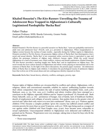
WAKHAN & the AFGHAN PAMIRIN THE FOOTSTEPS OF MARCO POLO
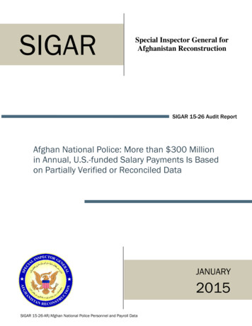
68ºE70ºEWakhan & the Afghan Pamir72ºE74ºEDushanbeWAKHAN capped 7000mHindukush peaks beckontrue mountain loversKyrgyz nomads in the heartof the Afghan Pamir preservea vanishing way of lifeRare and spectacularwildlife roam isolated highelevation valleysSparkling mountain lakes ofZorkol and Chaqmaqtin feedCentral Asia’s mighty Oxus RiverAncient Silk Road caravanhistory inscribed in petroglyphsshowcases the nFaizabadKunduzKhandudTaluqanIshkashimUKQila-e PanjaSarhad-e Broghilsee route mapQazidehUSNearest InTERNATIONAL AirportKabulNoshaq7492mNearest Domestic KTUIRANJalalabadN34ºN01002040 2006 Mareile Paley6020080100300 Kilometres200 MilesKHYBERPASSGateway TownIshkashimKAZAKHSTANDistrict ain VillagesQazideh, Qila-e Panja,Goz Khun, Sarhad-e istrictWakhanIslamabadNEPAPopulationapproximately 12,000in 1500 householdsLLanguagesPersian, Wakhi and Kyrgyz“We were glad to seek shelter fromthe keen air of these breezyaltitudes in the felt tents of theKyrgyz of the Afghan Pamir.”Sir Aurel Stein
DISCOVERING WAKHANWAKHAN IS A LAND SO REMOTE THAT FEW OUTSIDERS HAVE EVER VENTURED THERE. YET THROUGH WAKHANFLOWED A VITAL BRANCH OF THE GRAND TRANS-ASIAN ARTERY KNOWN AS THE SILK ROAD, LINKING EAST TO WEST.PETROGLYPHS DEPICTING WARRIORS, HUNTING SCENES, CARAVANS AND BUDDHIST HISTORY, ALONG WITH THEOCCASIONAL RABOT OR TRAVELLERS’ SHELTER, BEAR SILENT WITNESS TO THE TRACKS OF TRADITION, AND OFFERTHE VISITOR A GLIMPSE INTO THE RICH HERITAGE OF PILGRIMS, CARAVANS AND ARMIES THAT ONCE TRAVERSEDTHIS CLASSIC ROUTE.The great explorers who visited Wakhan are still asource of inspiration and wonder for today’s intrepidtravellers – Hsuan Tsang, the 7th century Chinese monkwho went in search of Buddhist teachings; Marco Polo,who in the 13th century journeyed overland to China;Mirza Muhammad Haidar, who chronicled the MoghulEmpire in the 16th century; Lieutenant John Wood andLord Curzon, Englishmen who searched for the source ofthe Oxus River in the 19th century; Sir Aurel Stein, the20th century British archeologist who sought to unravelthe Buddhist history of Innermost Asia; and mountaineerH.W. Tilman who sought unknown routes across themountain ranges.Snowcapped peaks soar majestically above villagesand glaciers descend precipitously to feed raging riversin this land of immense scale, beauty and contrast. Onthe Afghan Pamir, the unimaginably wide open spacesseem to extend forever. Here you’re more likely to bumpinto a big-horned sheep or a brown bear than anotherhuman being.Yet Wakhan is also home to hardy mountain people– Wakhi farmers and herders, who greet guests withunmatched hospitality – a warm smile, a cup of tea and abowl of yogurt – and the last remaining Kyrgyz nomads,whose welcoming yurts dot the fertile grasslands of theAfghan Pamir.www.wakhan.org“In the middle of the Pamir valley isa great dragon lake, clean and pure as amirror; the colour of the lake isdark blue and the taste ofthe water sweet and soft.”Hsuan TsangTHE AFGHAN PAMIRTHE LANDPamir are unique U-shaped, high-elevation mountainvalleys distinctive to Central Asia, where there are morethan half a dozen named pamir. Renowned as summergrazing grounds for their abundant grass and water,these vast plateaus are covered by snow six monthsof the year.Afghanistan’s Wakhan District is a narrow strip of landseparating Tajikistan and Pakistan that juts eastward some350km to meet the China border. Wakhan District has twodistinct parts – the Wakhan Corridor and the Afghan Pamir.All of Wakhan lies at elevations higher than 2000m and theAfghan Pamir lies above 3500m.with Pakistan, has 38 summits higher than 7000m, includingAfghanistan’s highest peak Noshaq (7492m). Permanentsnow blankets Wakhan’s highest peaks. The high, open valleysbetween these three mountain ranges form the Afghan Pamir,known in Persian as the Bam-e Dunya, or the “roof of theworld,” which is home to Kyrgyz nomads.The Afghan Pamir include two such grasslands at theeastern end of Wakhan – the Big Pamir and the LittlePamir, which are better known by their Persian names.The Big Pamir or Great Pamir is called Pamir Kalanand Pamir-e-Buzurg (kalan and buzurg both mean‘great’ or ‘large’). The Little Pamir is called Pamir Khurdand Pamir-e-Kochak (khurd and kochak both mean‘little’ or ‘small’).The Wakhan Corridor is a deep valley formed by the Panj Riverthat courses between the 7000m peaks of the Hindukush tothe south and the lofty mountains of Tajikistan to the north.Along the south bank of the Panj River and its upper tributary,the Wakhan River, are numerous Wakhi villages. The villagesbetween Ishkashim and Qila-e Panja are termed LowerWakhan. More than 5000m of vertical relief commands thesouthern horizon of Lower Wakhan, where the valley is asbroad as 2km. The villages in Upper Wakhan between Qila-ePanja and Sarhad-e Broghil lie along the more narrow banksof the Wakhan River, which opens to a dramatic river basin3km wide at Sarhad-e Broghil. Streams fed by precipitousHindukush glaciers cut across the Wakhan Corridor and flowinto the main river.High passes called kotal transect the mountain ranges andwere used by armies and ancient trade caravans. In theAfghan Pamir, passes, although at high elevation, are relativelyeasy for people to cross. The passes across the more ruggedHindukush are more difficult. The key Hindukush passes are:Broghil Pass (3882m) and Darwaza Pass (4288m) to Chitral;Khodarg Werth (or Khora Bort Pass) to Ishkoman; and IrshadUween (4979m) and Dilisang Pass (5290m) to Gojal.The 60km long Big Pamir nestles between the SouthernAlichur Range to the north and the Wakhan Range tothe south. The Little Pamir, at 100km long and 10kmwide, is actually larger in area than the Big Pamir, yetthe more rugged Big Pamir has a higher elevation andso earns its name. The proper name ‘Pamirs’ typicallyrefers to the Central Asian mountain range that extendsfrom Tajikistan into Afghanistan and China.Three mountain ranges – the Hindukush, Karakoram andPamir – converge in Wakhan to form what is called thePamir Knot. The Hindukush Range, which forms the borderTHE MOTHER RIVERAll of Wakhan is a semi-arid zone. In the Wakhan Corridor,agriculture is only possible through irrigation, fed bymeltwater in the streams descending from the mountains.Apart from occasional clusters of shrubs or willow, birch andother small trees, the landscape is largely barren of vegetation.Above 3500m, the valleys widen onto the expansive AfghanPamir with its lush seasonal meadows, peaty soil, and vividblue lakes.The Amu Darya or “Mother River” is the Persian namefor the river that classical Greek geographers called theOxus. It forms much of Afghanistan’s northern borderwith Tajikistan and Uzbekistan and courses more than2400km across Central Asia to the Aral Sea. The AmuDarya, one of Afghanistan’s four major river systems,has its source in the icy heights of the Pamir Mountainsat the head of Wakhan’s Wakhjir Valley. Joined by thestream coming from Chaqmaqtin Lake south of BozaiGumbaz, it becomes the Wakhan River, which is metat Qila-e Panja by the Pamir River flowing from Zorkol.Downstream of Qila-e Panja, the river is called theAb-e Panja (Panj River) and flows through a deep gorgeforming the border between Afghanistan’s BadakhshanProvince and Tajikistan. Finally, east of Kunduz, it’s joinedby Tajikistan’s Vaksh River and becomes the Amu Daryafor the remainder of its course across Central Asia.The Oxus is a river whose headwaters,“tell of forgotten peoples and secrets ofunknown lands, and are believed to haverocked the cradle of our race.”Lord Curzon
WAKHAN ACTIVITIESCULTURAL CONSIDERATIONSA JOURNEY THROUGH WAKHAN IS THE VERY ESSENCE OF ADVENTURE TRAVEL. AROUND EVERY TURN IN THE ROADOR TRAIL ARE TANTALIZING MOUNTAINS, UNKNOWN WILDERNESS, AND FASCINATING VILLAGES AND NOMADCAMPS. WITH EVERY STEP DEEPER INTO THE MOUNTAINS, YOU DISCOVER A WHOLE NEW WORLD OF ADVENTURE.WALK ALONG THE ROAD, WANDER THROUGH VILLAGES, EXPLORE THE INVITING MOUNTAIN PASSES. TRAVEL WITHTHE GRACIOUS AND HOSPITABLE PEOPLE WHO LIVE HERE, SHARING THEIR HARDIHOOD. EXPERIENCING THESEMOUNTAINS FIRST-HAND IS INCOMPARABLE AND UNFORGETTABLE.Trekking, by far the most popular activity in Wakhan,is traditionally a multi-day overland journey on foot involving the support of a trek crew who transport your personal belongings and gear such as tents, food and cookingequipment. Today’s trekking styles vary from backpackingwhere you carry everything yourself, trekking with porterswho transport your gear using pack animals (yak, donkey,camel or horse), buying an animal and leading it yourself(usually a donkey, hence the name donkey trekking), orhiring a tour operator who organises your trek.Distances in the Afghan Pamir are so great that youmay want to hop a ride during part of your trek (calledyak trekking). Yaks, strong shaggy beasts, are regularlyused by local people to transport gear, but are also funto ride and useful for crossing rivers rather than fordingthem. In winter when rivers are frozen solid, it’s possiblefor intrepid travellers to move on these icy pathways intraditional caravans of double-humped Bactrian camels.It’s more common, especially with Kyrgyz, to travelon horseback. Horse trekking, where your horse is yourtransportation vehicle and your travelling companion,allows you to move faster than on foot, relieves you ofhaving to transport gear separately, and also facilitatesnavigating river crossings and steep slopes. You can gohorse trekking even if you have little experience withhorses by hiring a horse trekking tour operator.www.wakhan.orgThe unique attractions for mountaineering inWakhan are several easily accessible 7000m peaks of theHindukush, including Afghanistan’s highest peak Noshaq(7492m), and numerous peaks higher than 6000m awaiting first ascents. The glaciated side valleys in the Big Pamiroffer a host of virgin peaks. Extreme adventurers will find aplayground for climbing and ski mountaineering.The isolation and remoteness of Wakhan, its naturalbeauty, and its cultural diversity are ideal for culturaltouring in 4WD vehicles. Exploring the cultural heritage,meeting people on village walks, day hiking and untrammelled camping each night combine to please the mostventuresome visitors.Unlimited opportunities for photography and discovering the rich natural history abound. Birdwatching,easily combined with other activities in Wakhan, is superb.Some of the best is along the Panj River and Wakhan Riveras you drive between Ishkashim and Sarhad-e Broghil. Theupland rivers and lakes are nesting grounds for geese,ducks and ibises, as well as spring and fall stopovers formigratory waterfowl and raptors. Marshy flats and oxbowlakes provide year-round habitat for many wading birds.The pristine natural environment boasts ideal wildlifeviewing where charismatic species such as Marco Polosheep (Ovis ammon polii), snow leopard (Uncia uncia), andTHE WEATHERbrown bear (Ursus arctos) make their home, particularly inthe Wakhjir Valley and in the numerous side valleys of theBig Pamir. The whistling alarm call of ubiquitous long-tailedmarmots (Marmota caudata) alerts you to their presencebefore they dive into their burrows. (Inadvertently stepping into a marmot burrow may be the greatest physicaldanger for anyone trekking in the Afghan Pamir!) Greywolf, red fox, Afghan urial (Ovis orientalis), ibex (Capraibex), and other wild cats also thrive in this high and wildterrain. Ethereal and wonderfully unique butterflies gracesummer wildflowers.A few ambitious cyclists have already made theirway to Wakhan. The road through the Wakhan Corridoris there for mountain biking, but you’d better be a goodbike mechanic and have an ample supply of spare partsand tires.Wakhan is an undiscovered, uncrowded gem notyet on the tourist map of the world. Cultivate a spirit ofadventure and open heartedness, and add to it self reliance, sound judgment and good planning and you havethe recipe for an unforgettable trip to one of the earth’smost exotic landscapes.Wakhan is at its best during the short summer, whichlasts from late June to mid-September. It is followed by along winter from late September to early June with coldtemperatures and severe, snowy conditions characteristicof this subarctic mountain climate. Wakhan receivesfewer than 10cm of annual rainfall, much of it coming inthe form of snowfall. Infamously fierce winds known asbad-e Wakhan blow throughout the year, fueling summerdust storms and winter blizzards. Unpredictable andchangeable weather is a given in the mountains, and it cansnow any month of the year in the Afghan Pamir.WHEN TO GOThe tourist season in Wakhan is relatively short, starting inMay or June and lasting until September or early October.From April to early June, melting snow swells rivers andhigh water blocks road access to many areas, making somerivers crossings impassable by foot, animal or vehicle.Many areas only become accessible as of early July. Thelater in summer you travel, the easier it is to cross streamsand rivers, and the greater the likelihood of being able todrive as far as Sarhad-e Broghil. August to mid-Septemberis the optimal travel time. By early September, however,snow can close trails and roads for the season.THE RESPECTFUL TOURIST:behaves conservatively as a show of respect for the local cultureis humble and grateful when accepting offers of local food whilenot taking advantage of generous hospitality, and pays for foodand accommodationwears loose, long-sleeved, unrevealing shirts, and full-lengthpants that cover the ankleswearing a hat or scarf is optional for women travelling throughWakhi and Kyrgyz areas, but is advisable elsewhere in Badakhshandoesn’t drink alcohol in public viewrefrains from all public displays of affectioncontributes to the local economy by patronizing local businesses,hiring porters and buying local products, which encourages localpeople to conserve their natural resource baseasks permission before photographing people or sacred placesmakes donations through established organizations orrespected community leaders, and doesn’t give handouts tobeggars or childrenENVIRONMENTAL CONSIDERATIONSTHE RESPECTFUL TOURIST:lessens the negative impact on the environmenttravels in a small party to minimise overall impact, but avoidstravelling alonecooks on a kerosene stove avoiding wood or dung fires sincethese fuels are a scarce resource that belong to the local peoplebrings adequate warm clothing to avoid relying on campfiresfor warmthbathes, washes dishes and clothes with a basin and discardssoapy water at least 50m from water sourcesrelieves one’s self at least 50m from open water sources orcampsites since toilets don’t existburns rubbish that can be burnt and packs out other rubbishleaves campsites the same way they were on arrival; doesn’tclear vegetation, cut trees, limbs or branches, and doesn’t moverocks from walls or canalsdoesn’t write names or mark graffiti on rocksdoesn’t hunt or trade in endangered speciesrefrains from harassing or feeding wildlife or eating wild gamepatronises tour operators who commit to environmentallyresponsible tourismTHE RESPECTFUL TOURIST:is law abiding and obtains necessary permission(s) for the routerespects the sovereignty of international borders and obtains allrequired permission for cross-border routestakes responsibility for one’s actions and avoids foolhardy decisionsRECOMMENDED ITINERARIESfromIshkashim WITH ONE WEEKDrive to Sarhad-e Broghil enjoying beautiful scenery, village walks,diverse cultural exchanges, and visits to intriguing roadside tombs,shrines and petroglyphs.A shorter road trip as far as Qila-e Panja allows for a side tripto the confluence of the Pamir and Wakhan Rivers and a visitto Avgarch village.The spectacular route to Noshaq Base Camp offers world-classtrekking just an hour’s drive from Ishkashim.WITH TWO WEEKSTry one longer route to picturesque Zorkol in the Big Pamir,or to the nearest Kyrgyz camps in the Little Pamir.Combine two routes by traversing the Big Pamir starting fromGoz Khun to Zorkol, and then to Sarhad-e Broghil in Upper Wakhan.Attempt a cross-border route from Sarhad-e Broghil in UpperWakhan to Pakistan’s Northern Areas.WITH THREE WEEKSVisit Chaqmaqtin Lake in the Little Pamir and outlyingKyrgyz settlements.Enjoy wildlife viewing in the Little Pamir’s Wakhjir Valley.Combine routes by visiting the Big Pamir and more remoteareas of the Little Pamir.
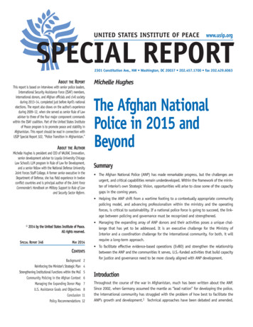
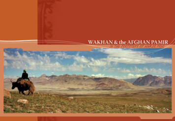
Wakhan & the Afghan Pamir RoutesQila-e Panja to Sarhad-e BroghilBroghil PassZorkol River RouteZorkol High RouteKotal-e ShaurKashch Goz High RouteKashch Goz River RouteChaqmaqtin LakeWakhjir ValleyIrshad UweenDilisang PassS OR NH ETUA L I C H U eUWEEN-E-SAR4887m155jPanerRivLangar20 Kilometres101520 MilesQila-e PanjaKhandudGoz KhunWuzedAvgarchSastSarhad-ePurwaksh Neshtkhwar Ptukh BroghilKOTAL-E SARGEZShelkSargezWardiKretNirsBROGHIL PASSBaba Tungi6513m3882mDALIZ PASSNLangarBorakWakT Ato MastujLashtH U N VA LKILIK PASS4927m4827mMINTAKA PASSWakhjir River4726mDILISANG PASS4267m5290mDILIDARWAZA PASS4288mSANGIRSHAD UWEENKarambarLakeYA R KWAKHJIR PASSiverhan RVA4979mBabaGhundiKARAMBAR ANto Ishkashim 2006 Mareile Paley / Markus Hauser4595m4320mCHILINJI AN5160mLLEYto Kashgarm010KOTAL-E WUZEDCHAP U R S A N VA L LZood KhunEYra5AQBELIS PASS4820m4872mKalam Darchito Misgarkoseasonal settlement0KOTAL-EQARABELKoh-e Pamir6320mrasmaller villageKOTAL-E TEGERMANSUBozai GumbazKashchGozto GilgitKaPamirmain villageNShaymakR A NG EZorkolHighw a y
WAKHAN & THE AFGHAN PAMIR ROUTESBIG PAMIRNOSHAQ BASE CAMPZORKOL RIVER ROUTE (see on route map)KOTAL-E SHAUR (see on route map)DURATION5-6 days round tripSTANDARDmoderateSTART/FINISH Qazidehvisit base camp (4450m) of Noshaq (7492m), Afghanistan’shighest summit and second highest peak in the Hindukushsuperb close-up views of four 7000m peaksWakhan’s best short trektrailhead less than one hour’s drive from IshkashimDURATION8 days round tripSTANDARDmoderateSTART/FINISH Goz KhunZorkol, largest lake in the Afghan Pamir (20km by 2-5km)stunning scenery along Pamir River with no passes to crosseasier and shorter route than Zorkol High Routeside trips possible to several side valleys linking to Zorkol High RouteDURATION10 days round tripSTANDARDdemandingSTART/FINISH Sarhad-e Broghillinks Upper Wakhan with Zorkoloption to link Big Pamir with Little Pamir routescross three passes each way: Daliz (4267m),Kotal-e Qarabel (4820m) and glaciated Kotal-e Shaur (4890m)impressive high mountain scenery from Kotal-e ShaurUPPER WAKHANQILA-E PANJA TO SARHAD-E BROGHIL (see on route map)DURATION3-4 days one waySTANDARDeasySTARTQila-e PanjaFINISHSarhad-e Broghilwalk along road visiting friendly Wakhi villagesalternative when road to Sarhad-e Broghilis blocked by landslides or floodsgood views of Baba Tungi (6513m)ideal for donkey trekkinghot spring in Sarhad-e BroghilBROGHIL PASS (see on route map)DURATION1 daySTANDARDeasySTART/FINISH Nirsbroad, grassy (3882m) pass on Afghanistan-Pakistan borderperfect for horseback ridinghistoric pass, lowest pass across Hindukush Rangeside trips to ancient forts above villages en routeWarning: Crossing the Broghil Pass into Pakistan is not permitted.www.wakhan.orgZORKOL HIGH ROUTE (see on route map)DURATION10 days round tripSTANDARDdemandingSTART/FINISH Sargez or Wuzedchallenging route crosses three passes (4300m-4500m) each waywildlife watchingtrekking peak possibilitiesWakhi summer settlements and Kyrgyz campsROUTE DIFFICULTYtrails below 3500m, 3-4 days500m daily elevation changeno pass crossings, no glacier travelMODERATE: trails below 4500m, less than 1 week1000m daily elevation changecross a pass below 4500mDEMANDING: trails below 5000m, 1 week or more1500m daily elevation changecross a pass below 5000mless than one day nontechnical glacier travelVERY DEMANDING: rugged trails below 5000m, 1 week or more2000m daily elevation changecross a glaciated pass above 5000mone day technical glacier travelEASY:CROSS-BORDERLITTLE PAMIRLOWER WAKHAN“There is nothing in my experience morefascinating than finding and crossing anunknown pass across a mountain range.The more important the watershed,geographically speaking, the moresatisfying the achievement.” Eric ShiptonKASHCH GOZ HIGH ROUTE (see on route map)CHAQMAQTIN LAKE (see on route map)DURATION9-10 days round tripSTANDARDdemandingSTART/FINISH Sarhad-e Broghilcross three passes each way: grassy Daliz (4267m),snow-covered Uween-e-Sar (4887m) andflower-carpeted Aqbelis (4595m)petroglyphs at Sang NevishtaWakhi summer settlements and Kyrgyz campsaccessible during summer when Kashch Goz River Routeis blocked by high waterDURATION9-11 days round tripSTANDARDdemandingSTART/FINISH Sarhad-e Broghilrenowned lake, source of Murghab River or Aksusecond largest lake (9km by 2km) in the Afghan Pamirfollow Kashch Goz High Route or River Route to Kashch Gozallow at least 1 day each way between Kashch Goz and lakeKyrgyz tombs at Bozai Gumbazseveral Kyrgyz camps along routehot springside trip to Tegermansu (3-4 days one way from ChaqmaqtinLake) and Kotal-e Tegermansu (4872m) on Afghanistan-Chinaborder, easternmost area of Little PamirWarning: All passes leading into Tajikistan and Chinaare strictly off-limits to foreigners.KASHCH GOZ RIVER ROUTE (see on route map)DURATION6-7 days round tripSTANDARDmoderateSTART/FINISH Sarhad-e Broghilcross one pass each way: Daliz Pass (4267m)one day shorter than Kashch Goz High RouteWakhi winter settlements at Langar, and Kyrgyz campsroute along Wakhan River used only when low water and in winterWAKHJIR VALLEY (see on route map)DURATION14-16 days round tripSTANDARDdemandingSTART/FINISH Sarhad-e Broghilsuperb wildlife viewing in upper Wakhjir Valleyremote wilderness of breathtaking beautyprimary source of the Oxus Riverfollow Kashch Goz High Route or River Route to Kashch GozWarning: The Wakhjir Pass (4927m) on the Afghanistan-Chinaborder is strictly off-limits to foreigners.“At Sarhad, the Oxus bursts from thegorge and, rejoicing in its freedom,spreads in meandering streams overa wide flat stony valley.” H.W. TilmanAnyone in search of real adventure will relish theworld-class mountain travel opportunity of across-border route.Special permission for cross-border routes fromthe Little Pamir to Pakistan’s Northern Areas isrequired from the governments of both Afghanistanand Pakistan in addition to obtaining visasfor both countries (see the Wakhan Travellers'Information insert for further information).IRSHAD UWEEN (see on route map)DURATION8-9 days one waySTANDARDdemandingSTARTSarhad-e BroghilFINISHChapursan Valley, Northern Areas, Pakistanhistoric trading route from Little Pamir’s Bai Qara Valleyto Chapursan Valleycross one 4979m snow-covered, but nonglaciated passchallenging river crossingsmulti-coloured rock formationsallow 4 days between Kashch Goz and Baba GhundiDILISANG PASS (see on route map)DURATION11-12 days one waySTANDARDvery demandingSTARTSarhad-e BroghilFINISHMisgar, Northern Areas, PakistanLittle Pamir’s Wakhjir Valley to Misgarcross one or three passes en route to Wakhjir Valleycross one 5290m glaciated pass on Afghanistan-Pakistan borderspectacular high mountain experienceside trip to head of Wakhjir Valley (2-3 days)
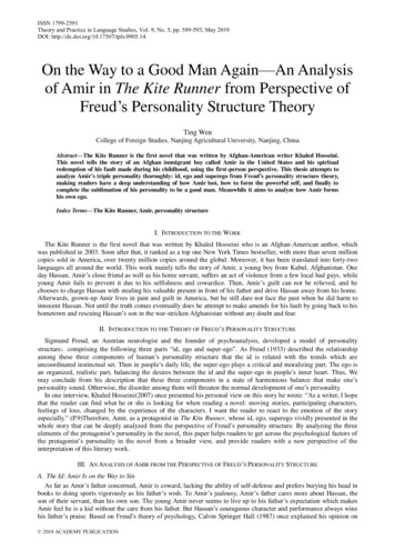
THE PEOPLEFor more than 2500 years the Wakhan Corridor has beenthe homeland of Wakhi people, who refer to themselvesas Wakhik or Khik. Today about 10,000 Wakhi live inAfghanistan’s Wakhan District, with another 40,000 living inadjacent areas of Tajikistan, Pakistan and China. Wakhi live inyear-round villages extending from Qazideh (2800m) at thewestern end of Lower Wakhan to Sarhad-e Broghil (3300m) atthe eastern end of Upper Wakhan. Wakhi people are farmers,who cultivate wheat, barley, peas, potatoes and a few apricottrees at the upper limits of agriculture, where production israrely sufficient. Chinir, a festival celebrating the start of thebarley harvest, occurs around the first week of August. Wakhidepend on livestock to supplement their agriculture, andalmost all households have some animals. Wealthier familieshave many sheep, goats and yaks along with a few camels,horses and donkeys. Every summer, Wakhi people take theirlivestock to summer pastures as high as 4500m, where theanimals grow fat on abundant grass. Wakhi people speakWakhi, which they call Khikwor. It belongs to the Pamir groupof Iranian languages and is spoken throughout Wakhan. Mostmen also speak Persian, which is used as a link language tocommunicate with people from other parts of Afghanistan.Wakhi people are Isma’ili Muslims, whose spiritual leader isthe Aga Khan.www.wakhan.orgKUCHHerecouldgoacaptionThe annual seasonal migration, or kuch, of Wakhi people andTrek toTegermansutheir livestockto andfrom summerValley.pastures is a colorful sight.THE KYRGYZYaks piled high with cauldrons, bedding and household goodsmove along the trail, while large mastiff-like dogs trot besidethem. Wakhi women, swathed in red scarves and shawls, rideon yaks and camels with young children clinging behind theirmothers. Infants ride in cloth-draped cradles perched on thebacks of yaks and the men walk alongside, leading the yaks, orride on horses.The spring migration usually departs from the villages inthe first week of June. During the summer, the kuch movesprogressively upvalley to higher grazing areas, and in autumnthey retrace their routes downvalley. The joyous returnmigration arrives in the villages in the second or third weekof October. Travellers may encounter these caravans in theAfghan Pamir, especially on trails leading to and from theLittle Pamir. 2004 John MockTHE WAKHICentral Asia’s Altai mountains along the western border ofMongolia are the traditional home of the Kyrgyz, a Turkicpastoral nomadic group. Each summer, small bands ofKyrgyz would migrate from lower valleys in Central Asia tothe Afghan Pamir, but following the 1917 Soviet revolution,several thousand Kyrgyz settled permanently in the Big Pamirand Little Pamir. Their once wide-ranging migration becamea series of short, seasonal movements within the closedfrontiers of the high-altitude Afghan Pamir. Kyrgyz live in feltyurts or oey, which they move seasonally according to availablepasture, sunlight and shelter from wind. Their settlements liebetween elevations of 4000m and 4500m. The Kyrgyz tendherds of fat-tailed sheep, goats, yaks and Bactrian camels,and trade with Wakhi neighbors or travelling merchants forall their needs not supplied by their livestock. Following theSoviet-backed 1978 coup in Afghanistan, some 1300 Kyrgyz,led by Haji Rahman Qul, left the Afghan Pamir for Pakistan.In 1982 this group of Kyrgyz was resettled in the mountainsof eastern Turkey. Today, about 1400 Kyrgyz remain in theAfghan Pamir. Their language is also called Kyrgyz, which isfrom the Kipchak group of northwestern Turkic languages.Most Kyrgyz men also speak Wakhi. Like all Turkic people,Kyrgyz are Sunni Muslims.“It was a delightfully cosy yurt, carpetedwith bright felt rugs. Plenty of embroideredcushions and other fineries attested theowner’s wealth and comfort.”8Sir Aurel Stein
WAKHAN ACROSS THE CENTURIESVisit www.wakhan.org for updated Wakhan travellers’ information.WAKHAN TRAVELLERS’ INFORMATION 2004 John MockENGLISHHow are you (doing)?I’m fineHow are you?I’m wellWhere are you going?What is your name?My name is .What is that?I’m tiredSit downDrink teaEat foodGo!Numerous rock carvings bear silentwitness to the tracks of traditionthat traverse Wakhan.GREETINGSWAKHIKYRGYZENGLISHWAKHIchiz hol he?bidurt emtut sīyeta?wuzem sīyetkumeret takh?tī nunge chīst?zhu nunge .yāoī chīz?washk vitknezditachoī pevshapīk yāochowabalëngëz qanday?jaqshëözüungüz qandaysëz?jaman emeskayda barasëz?atëngëz kim?menim atim .Bul emne?men ajëzolturunguzich chayjhe tamaqketyes/noWhere is . available?I need .how?how ningyesterday/today/tomorrowbeautifulfirehouse (yurt)mountainrockstream (glacial/clear)yan/net. esh kumer goten?mārey . dirkortse ardur/zheravhello (peace be with you)and with yougoodbye (God be with you)asalaam alekumwa alekum salaamkhuda hafizKYRGYZENGLISHoshondoy/joq. di qayerden?magha . kerekqancha pul/turat?bul emne?qachan?qachan?qayerde?kit?kun/tunerteng menen/kechkechee/bügün/ertengsupuotoeytootoo troītsaburpānzshāthhubhāthnaothasbuwista nelüübir jüzGETTING THERE – TO AFGHANISTANBy AirAfghanistan’s capital Kabul has regional air links with its neighbouringcountries of Iran (Tehran), Tajikistan (Dushanbe), China (Urumqi) and Pakistan(Islamabad, Quetta), but lacks air links with Turkmenistan and Uzbekistan.International flights to Kabul also operate from India (Delhi, Amritsar),United Arab Emirates (Dubai, Sharjah), Saudi Arabia (Jeddah, Riyadh), Kuwait(Kuwait City), Turkey (Istanbul, Ankara), Russia (Moscow) and Germany(Munich, Frankfurt).By RoadForeigners can enter Afghanistan by road from Iran (Mashad to Herat),Pakistan (Peshawar to Kabul via the Khyber Pass), and Tajikistan’s GornoBadakhshan Autonomous Oblast (at Ishkashim). The Ishkashim bordercheckpost is a two-hour drive from Khorog, which has air links with Dushanbe,or a two-day road trip from Dushanbe.Turkmenistan, Uzbekistan (the road Hairatin to Mazar-e Sharif is only opento “official” traffic), and China do not have any road links open to foreigners.The Afghanistan-China frontier is a military zone, which
true mountain lovers Kyrgyz nomads in the heart of the Afghan Pamir preserve a vanishing way of life Rare and spectacular wildlife roam isolated high elevation valleys Sparkling mountain lakes of Zorkol and Chaqmaqtin feed Central Asia's mighty Oxus River Ancient Silk Road caravan history inscribed in petroglyphs showcases the archeology